March: 4th consecutive month of cooler-than-average temperatures in St. Cloud (4.1 F. cooler than average in the Twin Cities).
November 10: last time the mercury surpassed 60 F. in St. Cloud (63 F at STC).
October 11: last time temperatures rose above 70 in the St. Cloud metro area (80 F.)
Twins Home Opener: Intervals of sun, probably dry, temperatures ranging from 55-60 F Friday afternoon at Target Field.
Saturday: more like early May with highs ranging from mid 60s (St. Cloud area) to near 70 in the Twin Cities, a shot at 80 over far southern Minnesota - with more clouds, the chance of showers/storms increasing as the day goes on. Slight chance of a few severe thunderstorms.
Sunday: lingering showers, possible thunder - cooling off later in the day.
Heaviest Rains: may arrive Saturday evening into Sunday night. Latest solutions show a slower, more intense area of low pressure, capble of prolonging rain (and T-storms) much of the weekend.
.50+" rainfall amounts possible over the weekend. It's too early to know what the impact will be on Minnesota's rivers.

Official: Government Shut-Down Would Not Halt Vital Weather Services. Even if politicians in Washington D.C. fail to come up with a compromise to keep the federal government going, some vital services will remain: social security check processing, air traffic control, security screenings at America's airports, and many critical National Weather Service services. Here's an
update from the Capital Weather Gang at the Washington Post: "As a potential
shutdown of the Federal government draws closer, a looming question is: what would happen to products and services provided by the National Weather Service (NWS) ? Would NWS continue to issue forecasts, watches, warnings, and advisories? A NOAA official says yes. “Agency operational plans are still being finalized, but our current understanding is NOAA will provide weather services to protect lives and property,” the official said. “We still believe there is an opportunity to avoid a government shutdown, but are working to ensure that we are prepared for all possible scenarios.” During the last Federal shutdown in 1996, NWS offices remained at least partially operational. For example, the NWS Office in Sterling, Va. disseminated forecasts and warnings during the
Blizzard of 1996 which coincided with the shutdown. In order to pay some contract employees and even utility bills at NWS offices, the agency used 1995 carry-over funds (according to an article published in the Washington Post on 1/17/96). NOAA officials have not provided specifics about which products and services are considered essential and would be supported during a shutdown."
Flood Update From Dan Luna, MIC at the Chanhassen National Weather Service. I asked Dan about the prospects of a rapid warming trend coupled with significant rain - what this means for Minnesota's rivers. Here is his response: "
We will see a second crest and higher in a few locations. At this point additional rain forecast Sunday will not add to the crest - only delay the rivers/streams from falling. If we were to receive over an inch of rain on a widespread basis in a 24 hour period, then we would see higher crests. Even those would not be much higher."
Update From Greg Spoden (MN State Climate Office):
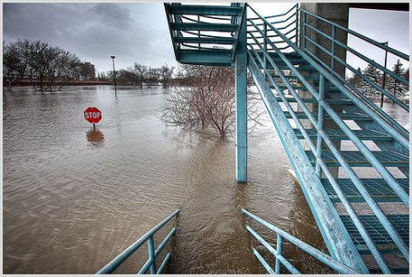
- Moderate to Major spring flooding is underway along many of Minnesota's rivers. Major flooding is occurring along the upper reaches of the Red River. Major flooding is expected this weekend in Red River communities such as Moorhead/Fargo and Halstad. Major flooding will begin early next week at locations such as East Grand Forks/Grand Forks, and later this month along the Red River at the Canadian border. An initial flood crest has already occurred along portions of the Minnesota and Mississippi rivers and their tributaries. A secondary, and potentially higher, crest is expected along portions of the Mississippi, Minnesota, and Crow rivers. Initial rises are still forthcoming for the Sauk, Long Prairie, and upper Mississippi rivers.
- March 2011 precipitation totals were variable across Minnesota. March precipitation was below normal in north central and northeast Minnesota, whereas portions of central and southeast Minnesota reported above-average precipitation for the month.
- A large and intense early-spring storm on March 22-23 brought rain, sleet, and snow to a good portion of Minnesota. Liquid precipitation totals of one to two inches were common and added to the flood threat. In most communities, this event accounted for the majority of the monthly precipitation for March.
- Monthly mean temperatures for March 2011 were below average across Minnesota. This was the fourth consecutive month of below-average temperatures.
For more details on Minnesota's evolving flood risk and state climate information click
here.
Hydrology Update from the Twin Cities National Weather Service. Details
here.
"VISIBLE SATELLITE IMAGERY FROM YESTERDAY INDICATED THE SNOW COVER
WAS DOWN TO BASICALLY THE NORTHERN TWO TIERS OF COUNTIES...WITH
SOME OF THE DEEPEST NEAR RICE LAKE AND LADYSMITH. GIVEN THE
FORECAST THIS WEEK...A GOOD PORTION OF THAT SNOW WILL
MELT AND THE FINISHING TOUCHES ON THAT SNOW COVER SHOULD BE THIS
WEEKEND WITH THE SURGE OF WARM AIR AND RAIN. WHILE RAIN LOOKS
LIKELY OVER SOUTHERN MN ON THURSDAY NIGHT...THE PRIMARY TIME
PERIOD FOR CONCERN IS INDEED THE WEEKEND. AT THIS TIME...ABOUT
ONE QUARTER OF THE MEMBERS OF A MODEL ENSEMBLE /GEFS/ ARE
PRODUCING ONE INCH OF RAIN DURING SATURDAY INTO SUNDAY IN
MINNEAPOLIS."
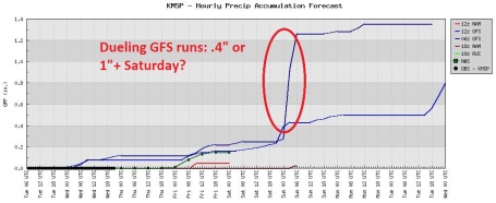
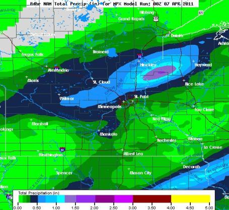 Latest Rainfall Prediction
. According to the latest NAM model, some .25 to .50" rainfall amounts are possible by Saturday evening over central and southern Minnesota, with over 1" predicted north/east of St. Paul. It's still too early to know (with any confidence) where the heaviest rain bands may set up, or whether showers and T-storms will create a "train-echo" effect, where cells keep forming and redeveloping over the same counties - which could result in considerably higher rainfall amounts.
How Much Rain? Place Your Bets. Now that we're in a more convective, showery, springlike pattern, predicting precise rainfall amounts becomes even more of a wing and a prayer. By Saturday some communities in southern Minnesota, directly under heavy thunderstorms, could wind up with over 1" of rain, while 10 miles away light showers drop 1 or 2 tenths of an inch. Expect a big variation in rainfall, but the ground is frozen/saturated; any rain that falls will almost immediately run off into streams and rivers.
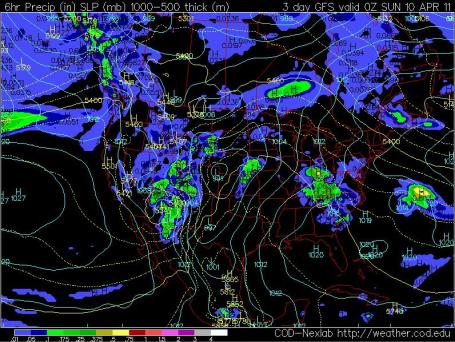
Saturday: Hints of May? Both the GFS and the ECMWF bring an impressive warm front into southern Minnesota by Saturday. South of the front (in the "warm sector" of the storm) temperatures may soar into the 70s and 70s. If the sun is out even for a few hours on Saturday we could easily hit 70 in the metro area. The more sun (and warmth) the greater the odds of strong T-storms bubbling up, in response to significant low-level moisture and strong wind shear. An isolated severe storm can't be ruled out Saturday or Saturday night. The map above is the GFS solution, valid Saturday evening.
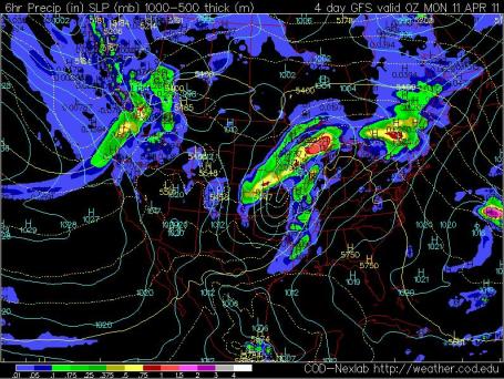
Sunday: Rain Lingers. The latest solutions (GFS and ECMWF) bring a secondary wave of low pressure across the Plains Sunday, prolonging the rain into most of the weekend. Earlier runs were hinting at a slow clearing trend for the PM hours Sunday - but the latest computer simulations slow the storm down, it's deeper, farther north/west. Translation: rain (and a few embedded T-storms)
may linger through much of the day Sunday. The result may be another half inch or more of rain - adding to the potential for a second (or even a third)
flood crest later in April.
Storm Uproots Famous Tree At Augusta. From the Associated Press: "
An overnight storm that swept through Augusta National left broken limbs all over the course and knocked down one of the famous trees along Magnolia Lane. Defending Masters champion Phil Mickelson noticed the gap when he arrived at the course Tuesday. "It was just disappointing that a tree that's been there for so many years was uprooted," he said. The storms toppled trees and some power lines across town. The club delayed its scheduled opening by 45 minutes to give workers time to clear debris so the practice rounds could begin. Chainsaws could be heard from various corners of the course. In the final minutes before fans were allowed on Augusta National, numerous carts were hauling away tree limbs. Some marshals were picking up debris from fairways."
Panic At The Masters - No Pimento Cheese. Oh the horror! Bizjournal.com has the terrifying
details: "The Masters is certainly known for its traditions and among them is Augusta National Golf Club’s pimento cheese sandwiches. But on Tuesday, due to power outages, fans on hand for practice rounds were shocked to find shelves at concession stands empty, save one lone concession stand near the patron corridor, reports The Augusta Chronicle. A severe thunderstorm that moved through Augusta caused a power outage at the production center where the sandwiches are made. "We were in disbelief when we walked in and heard there were no sandwiches," Reed Clevenger of Cary, N.C., who came to the tournament with a friend and both men's sons, told the Augusta paper. "We told (our sons) even if you don't like it, you have to try the pimento cheese at least once.". Power was being restored throughout the day on Tuesday and vendors predicted they’d get enough pimento cheese to keep everyone happy for the rest of the tournament.
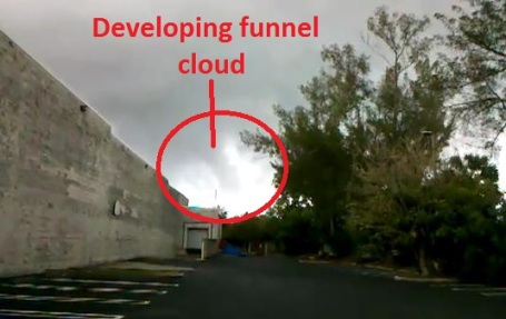
Developing Tornado. Check out CPKnight's video of a tornado forming near Fort Lauderdale (!) It was less than 1/2 mile away when he shot this clip, courtesy of
YouTube.
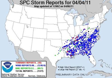
Severe Storm Recap. The numbers keep escalating for Monday's amazing severe weather outbreak: 43 tornadoes, 1245 reports of damaging winds, 89 reports of large hail, for a total of 1,377 severe storm reports over the southeastern USA. It came 37 years (to the day) from the "Super Outbreak" of April 4, 1974, when 148 tornadoes touched down in a single day. More details from SPC
here.
* Accu Weather has more on the EF-2 tornado that ripped into an auto plant outside Hopkinsville, Kentucky Monday, injuring 7 people in
this post. According to the local National Weather Service office there was 27 minutes lead time between when the tornado warning was issued, and when the plant was hit by winds estimated at over 110 mph. The average lead time for tornadoes has improved from roughly 6 minutes in the 70s to 12-14 minutes today. That's largely thanks to Doppler radar (which can pinpoint the rotating storms most likely to spin up tornadoes) and an improved network of volunteer spotters: Skywarn, police, fire and local civil defense, deployed to scan the skies and confirm which rotating storms on radar are actually producing wall clouds, funnels or tornadoes.
Hurricane Outlook For 2011. Here is the
latest outlook for hurricane season from meteorologists at Colorado State University: "In its 28th year of issuing predictions, the Colorado State University forecast team today predicted an above-average 2011 Atlantic basin hurricane season. The team slightly reduced its early December prediction, but still called for an active season based on current La Nina conditions that are expected to transition to near-neutral conditions during the heart of the hurricane season.
The CSU team now calls for 16 named storms instead of 17 forming in the Atlantic basin between June 1 and Nov. 30. Nine of those are expected to turn into hurricanes with five developing into major hurricanes (Saffir/Simpson category 3-4-5) with sustained winds of 111 mph or greater. “We expect that anomalously warm tropical Atlantic sea surface temperatures combined with neutral tropical Pacific sea surface temperatures will contribute to an active season,” said Phil Klotzbach of the CSU Tropical Meteorology Project. “We have reduced our forecast slightly from early December due to a combination of recent ocean warming in the eastern and central tropical Pacific and recent cooling in the tropical Atlantic.” “It is recommended that all vulnerable coastal residents make the same hurricane preparations every year, regardless of how active or inactive the seasonal forecast is,” Klotzbach said. “It takes only one landfall event near you to make this an active season.” The hurricane forecast team made this early April forecast based on a new forecast scheme that relies on 29 years of historical data. The hurricane team's forecasts are based on the premise that global oceanic and atmospheric conditions - such as El Nino, sea surface temperatures, sea level pressures, etc. - that preceded active or inactive hurricane seasons in the past provide meaningful information about similar conditions that will likely occur in the current year. The team’s annual predictions are intended to provide a best estimate of activity to be experienced during the upcoming season, not an exact measure.
Another symptom of La Nina? AP and MSNBC has the
story: "
COYLE, Okla. — In most years, the dark clouds over western Oklahoma in the spring would be bringing rain. This year, they're more likely to be smoke from wildfires that have burned thousands of acres in the past month as the state and its farmers struggle with a severe drought. Oklahoma was drier in the four months following Thanksgiving than it has been in any similar period since 1921. That's saying a lot in the state known for the 1930s Dust Bowl, when drought and high winds generated severe dust storms that stripped the land of its topsoil. Neighboring states are in similar shape as the drought stretches from the Louisiana Gulf coast to Colorado, and conditions are getting worse, according to the U.S. Drought Monitor. The area in Texas covered by an extreme drought has tripled in the past month to 40 percent, and in Oklahoma it nearly doubled in one week to 16 percent, according to the monitor's March 29 update."
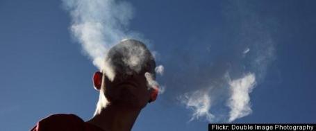
Second-Hand Smoke Linked To Kid's Depression, Anxiety, ADHD. An
article at Huffington Post caught my eye: "
Children and teens who are exposed to second-hand smoke could be at greater risk of suffering from mental health disorders like depression, anxiety and ADHD, according to a new study that's among the first to closely examine the potential association between second-hand smoke and mental health. Researchers writing in the Archives of Pediatrics and Adolescent Medicine, looked at nearly 3,000 children, aged 8 to 15. According to the U.S. Surgeon General, more than 60 percent of children between the ages of 3 and 11 are exposed to second-hand smoke. Smoke exposure in the children (who were part of the National Health and Nutrition Examination Survey conducted from 2001 to 2004), was determined by looking at serum cotinine levels -- a marker used to show how much smoke has entered the body. The 3,000 participants were also screened for potential mental disorders using the National Institute of Mental Health's Diagnostic Interview Schedule for Children questionnaire, which diagnoses for conditions included in DSM IV. Ultimately, researchers found that higher serum cotinine levels were linked to symptoms associated with major depressive disorder, generalized anxiety disorder, ADHD and conduct disorder, which the American Academy of Child and Adolescent Psychiatry defines as a group of chronic behavioral and emotional problems."
U.S. Atom Smasher May Have Found New Force Of Nature: Report. Some pretty amazing
news, courtesy of the New York Times and Yahoo News: "US physicists are to announce Wednesday that data from a major
atom smasher lab may have revealed a new
elementary particle, or potentially a new
force of nature, the New York Times reported. A spokeswoman from the US Department of Energy's Fermi National Accelerator Laboratory, which operates the powerful
particle accelerator Tevatron, said the results would be released at 2100 GMT but offered no further details. "Nobody knows what this is," said
Christopher Hill, a theorist at
Fermilab who was not part of the team, according to the New York Times. "
If it is real, it would be the most significant discovery in physics in half a century." The Times report said the findings relate to a "suspicious bump" in the physicists' data and could involve "a new and unexpected version of the long-sought Higgs-boson."
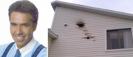
WFTS Meteorologist's House (in Tampa area) Hit By Lightning. This is why I put lightning detectors on my last house in Eden Prairie. Neighbors thought I was nuts (bulletin: I am), but I'm convinced those detectors saved us from a at least a half dozen lightning strikes. A hair-raising
story from Media Bistro: "
WFTS chief meteorologist Denis Phillips is used to being at the center of attention when severe weather rolls through the Tampa Bay area but he never expected that he’d actually be the target of it. “You won’t believe this…talk about irony,” Phillips wrote on his Facebook page on Tuesday. “House got hit by lightning today!” A single lightning bolt from a recent thunderstorm struck the side of Phillips’s house, carving a hole into the siding. Phillips explained: Two big black holes in the front of the house where the bolt went in, then came out. Suffice to say, electronics pretty much fried and pipes burst. See, it CAN happen to you! Ok, maybe not you, but certainly ME!"
AT&T Expanding 4G Network In Twin Cities. Will this help my iPhone reception? Here's a recent
story in the Star Tribune: "
AT&T is expanding its 4G wireless coverage in the Twin Cities metro area as part of a national rollout of improved mobile Internet service, the company said Monday. AT&T, Verizon Wireless and others are introducing 4G wireless Internet service for smartphones and computers that comes closer to the speeds that wired cable modems typically provide. The 4G service doesn't affect the quality of phone calls. Today, 4G networks are in their infancy and aren't widely available outside of cities. As part of its 4G expansion in the Twin Cities this year, AT&T said it will improve wired data-carrying connections to more than 300 wireless cell antennas, add about 10 new antenna sites and enhance 45 existing cell antenna sites so they can handle more traffic. Verizon Wireless also has been expanding its 4G network here. Sprint was the first of the big cellular companies to offer 4G service in the Twin Cities, but didn't build its own network, relying instead on a partnership with Clearwire Corp., which built cell-like towers that broadcast a different type of signal, called WiMax."
Winning? Charlie Sheen Booed Off Stage In Detroit. An
update from AP and the Huffington Post: "
There was no #winning for Charlie Sheen last night. The star, who kicked off his "Violent Torpedo of Truth" stage show in Detroit on Saturday, was booed off the stage as he berated the audience and spoke incoherently, stringing together a series of catchphrases that had both lost him his job on sitcom "Two and a Half Men" and turned him into an internet star/curiosity. As is his customary response now, Sheen is reportedly not upset, blaming the situation on the audience and not himself. He continues the live tour, a 20-date sojourn across North America, on Sunday night in Chicago. There are still no refunds available."
This Is Your Captain Screaming. Here's an amazing
story from Gizmodo: how a British pilot almost got sucked out of an airplane, but somehow managed to survive a horrifying ordeal. An excerpt: "
The plane was packed when, at 17,000 feet, the windscreen blew and the captain was sucked out. Nigel Ogden, who saved him by hanging on to his legs, tells his story for the first time to Julia Llewellyn Smith. It was like something from a disaster movie and I still find it hard to believe I was at the centre of it all. An aeroplane full of passengers, out of control at 17,000 feet, with the captain stuck outside the aircraft....I was still holding Tim, but my arms were getting weaker, and then he slipped. I thought I was going to lose him, but he ended up bent in a U-shape around the windows. His face was banging against the window with blood coming out of his nose and the side of his head, his arms were flailing and seemed about 6 feet [1.8 metres] long. Most terrifyingly, his eyes were wide open. I'll never forget that sight as long as I live."
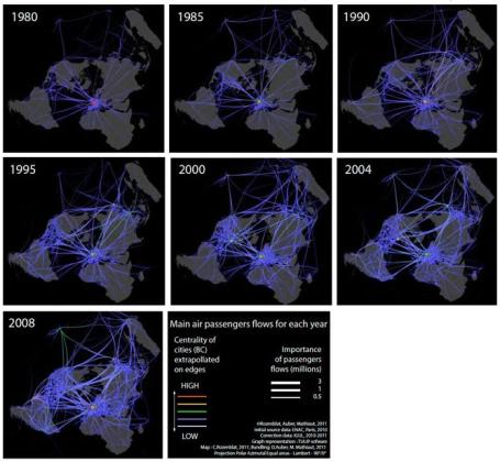 Data As Art: 10 Striking Science Maps
. I'm fascinated with story-telling, and using technology to come up with new ways of visualizing data. Seems like I'm hardly the only one. Wired.com has an intriguing series of visuals showing data visualization which you can see
here. The map above: "
Airline-passenger flow in the Northern Hemisphere is shown in these annual snapshots created using Tulip software. This visualization didn't win, but we are looking forward to a video the authors plan to release that will show the booms and busts of airline travel throughout the past 30 years.
 Tools of Tradecraft: Spy Gear From The CIA
. A lipstick gun? Talk about the kiss of death. Wired.com has an interesting
slide show looking at some of the tools used by CIA operatives and spies over the years: "
For the spy-op gone bad, or simply for any Natscha who found herself out to dinner with the date from hell, this Cold War-era KGB lipstick gun delivered the kiss of death with a single 4.5mm shot."
Photo: Courtesy International Spy Museum
Why They Call It The Milky Way. Astrophotographer Juan Carlos Casado captured this amazing photo of the Milky Way, actually a composite of 9 separate photos - available for gawking at
io9.com: "
In a clear sky from a dark location at the right time, a faint band of light is visible across the sky. This band is the disk of our spiral galaxy. Since we are inside this disk, the band appears to encircle the Earth. The above spectacular picture of the Milky Way arch, however, goes where the unaided eye cannot. The image is actually a deep digital fusion of nine photos that create a panorama fully 360 across. Taken recently in Teide National Park in Tenerife, Canary Islands, Spain, the image includes the Teide volcano, visible near the image center, behind a volcanic landscape that includes many large rocks. Far behind these Earthly structures are many sky wonders that are visible to the unaided eye, such as the band of the Milky Way, the bright waxing Moon inside the arch, and the Pleiades open star cluster."
Paul's SC Times Outlook for St. Cloud and all of central Minnesota:
TODAY: Partly sunny and mild. First 60 in nearly 5 months? Winds: SE 10-15. High: near 60
THURSDAY NIGHT: Mostly cloudy, probably dry. Low: 42
FRIDAY: A mix of clouds and some sun, probably dry for the Twins Home Opener High: 57
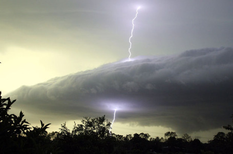
SATURDAY: More clouds than sun, breezy and unseasonably mild. Muggy with a few T-storms, some strong. Low: 48. High: 65
SATURDAY NIGHT: Muggy and mild with T-storms, some locally heavy rain possible. Low: 53
SUNDAY: Mild start, Lingering showers and possible T-storms into Sunday evening. High: 63 (falling into the 50s later in the day).
MONDAY: Damp start, then gradual clearing. Low: 39. High: 55
TUESDAY: Most ice off area lakes. Passing PM shower? Low: 41. High: 57
WEDNESDAY: Plenty of sun, pleasant. Low: 38. High: 56
First 60 of Spring?
Is it safe to take the stakes out of my driveway yet? I don't want to be blamed for the next slush-storm, so I'm going to hold off. Only in Minnesota: plowable snow (4-8" fell on March 23) to 70 F. and thunder, in just over 2 weeks. Remarkable. If we do hit 60 this afternoon (very possible) it will be the first time since November 10; according to the NWS it may be the latest 60 since 2002. Fun with statistics.
A sloppy front pushes north tomorrow, meaning more clouds, but odds favor dry weather for the Twins Home Opener, with highs in the mid 50s to near 60. At least it won't snow.
A vigorous storm surging northward across the Plains will push a May-like warm front into town by Saturday, sparking scattered T-storms. We can't even rule out a few isolated severe storms late Saturday. 60s are possible here Saturday; if the sun stays out for a few hours the mercury may graze 80 near Rochester! An intense, slow-moving storm tracking just south of Minnesota will keep showers (and a few heavier T-storms) in the area Saturday PM hours into much of Sunday. Over half an inch of rain may fall in the St. Cloud area, with some 1"+ amounts closer to the Twin Cities, Mankato and Rochester - not good for our flood situation.
The Red River may crest this weekend in Fargo, a little more than a foot below 2009's historic level. A second crest is likely on the Minnesota and Mississippi - stay tuned for flood updates.
Congress On Wrong Side Of History In Denying Climate Change. Here is a recent letter to Congress written by Rep. Betty McCollum and John Abraham, an associate professor of thermal sciences at the University of St. Thomas, published in The Hill's
Congress Blog: "
Right now in our hometown of St. Paul, Minnesota, we are preparing for what might possibly be record-breaking floods due to winter’s heavy snowfall and the threat of heavier spring downpours. Minnesota has already experienced two 100-year floods in the Red River Valley within the past 13 years. Local doctors report an increase in cases of children with asthma and other respiratory conditions. Lake Superior has seen record low water levels in recent years, threatening not only drinking water supplies but the Duluth-Superior port that receives more than 1,200 ships and 48 million tons of cargo. All of these public health, economic, and environmental trends have been strongly linked to climate change. Multiple studies have shown that 97 percent of the most qualified climate scientists are in agreement that humans are causing the planet to warm. If this was an illness, and 97 percent of doctors recommended a certain treatment, we would take appropriate action. Instead, the majority party in the House of Representatives is choosing to willfully defy the diagnosis and overturn established science by voting on a bill (H.R. 910) that will gut the Clean Air Act and prohibit the Environmental Protection Agency (EPA) from ever protecting the American people from the disastrous impacts of climate change."
What's Causing The Poles To Warm Faster Than The Rest Of Earth? A recent
story from NASA: "The poles are warming faster than other parts of the Earth – a fact that has been widely accepted for years. But what is causing the accelerated warming? Research aimed at answering that question has been done before, but a recent study by Patrick Taylor, a scientist at NASA's Langley Research Center in Hampton, Va., suggests a new reason. Taylor's research shows the Earth's poles are warming faster than the rest of the planet because of energy in the atmosphere that is carried to the poles through large weather systems. Decades of NASA data show the Earth is warming. According to NASA's Goddard Institute for Space Studies in Manhattan, the Earth has warmed about 1.44 degrees Fahrenheit during the last 40 years. But the poles are warming even faster; the Arctic has warmed by more than 3.5 degrees Fahrenheit during the same time period. "It was previously thought that amplified polar warming was caused by melting ice, lowering surface albedo," Taylor said."
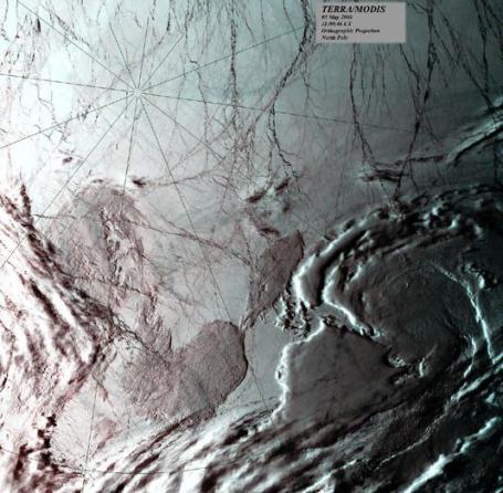
* Photo above: This true-color image over the North Pole was acquired by the MODerate-resolution Imaging Spectroradiometer (MODIS), flying aboard the Terra spacecraft, on May 5, 2000. Credit: Allen Lunsford, NASA GSFC Direct Readout Laboratory
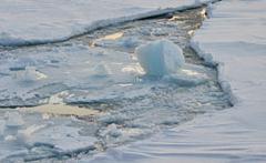
Turbulence Changes Arctic's Role In Climate Change. Here's a
post from Planet Earth Online: "
The loss of sea ice in the Arctic Ocean caused by a warming environment could be made worse by previously undetected turbulence, which has been identified by scientists from Bangor University. Until now the Arctic Ocean was thought to be relatively tranquil. But observations by an international team, lead by Yueng-Djern Lenn of Bangor's School of Ocean Sciences, show for the first time that different water layers are being mixed together by bursts of turbulence beneath the Arctic ice. Turbulence is caused by the action of the wind on the sea and ice; ice cover averages out the wind's effect, but when there is no ice the wind acts directly on the sea. When the wind blows in the opposite direction to the flow of water the turbulence is greatly increased."
Climate Change May Impact Instinction Risk of Animal Populations: Study. Here's a
story from the International Business Times: "
The colour of the environment is changing – becoming bluer – apparently due to climate change, says a new study that finds that environment and animal populations are fluctuating more rapidly over time. The change that could have important implications for animals' risk of becoming extinct, ecologists have found. Researchers examined how quickly or slowly animal populations and their environment change over time, something ecologists describe using "spectral colour". Ecologists have investigated the link between fluctuations in the environment and those of animal populations for the past 30 years. They describe fluctuations as a colour spectrum, where red signifies an environment or population that fluctuates more slowly over time (such as ocean temperature) and blue signifies more rapid fluctuations (such as changes in air temperature)."


No comments:
Post a Comment