* 113: number of tornadoes that touched down last year in Minnesota (MN State Climate Office).
* 145: SPC preliminary tornado count in Minnesota for 2010.
* 10: tornado-related fatalaties in Minnesota since 1992.
* 1983: last tornado-related death in the Twin Cities metro. On June 14, 1983 a tornado tracked from Edina to Roseville, killing one person, injuring 83.
* 1998: last year Ramsey county saw a tornado. (MN State Climate Office).
* Quarter-size hail: threshhold for severe storm warnings, roughly 1" in diameter.
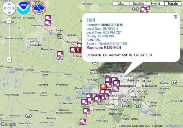
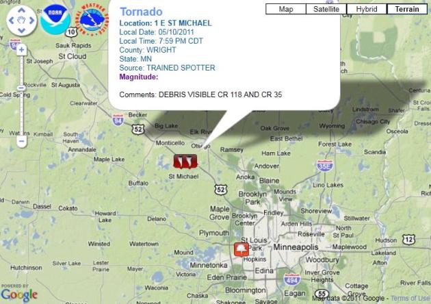
* 2.75" hail reported near Albertville Tuesday evening, roughly tennis ball size. This was the same "supercell" that went on to spin up a tornado near St. Michael.
* 1.5" of rain predicted by Sunday morning in St. Cloud (best chance of heavier showers Thursday afternoon, again late Saturday and Saturday night).

Cool, Soggy Fishing Opener Blues. Models continue to predict light rain showers and sprinkles on Saturday, a raw north wind - heavier/steadier rain possible late Saturday and Saturday night into the morning hours Sunday.
Saturday Details
Leech: 41-48 F. Rain. Winds: N 10-20
Whitefish Chain: 43-50 F. AM showers, PM rain. Winds: N 10-20
Mille Lacs: 45-53 F. AM Showers/sprinkles, PM rain. Winds: N 10-20
Minnetonka: 47-56 F. AM drizzle/sprinkles, PM showers. Winds: N 10-20
* Fishing Opener weather trivia from the Minnesota State Climatology Office below:
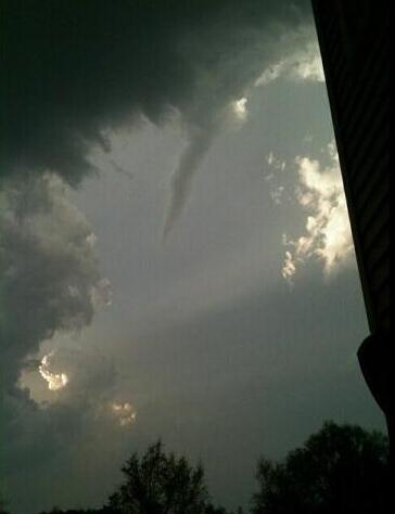
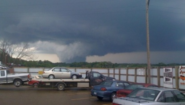
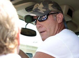
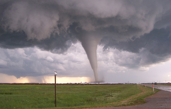
First Minnesota Tornado of 2011? WeatherNation meteorologist Todd Nelson snapped this photo (from his deck - as the funnel passes right over his house in St. Michael). There were reports of 2.75" diameter hail nearby - which underscores something I've been saying for 25+ years: when you see large hail it's a tip-off that a storm is especially severe, with a violent updraft capable of spinning up a tornado.
Why I'm Considering A Move To Ramsey County. Here is a great summary of Minnesota tornado stats, courtesy of the Minnesota State Climatology Office: "The most probable danger period in Minnesota, therefore, is late spring and early summer, between 2PM and 9PM. However, tornadoes can and do occur at any time of the day or night. Despite a higher number of tornadoes reported in recent years, the number of fatalities and injuries due to tornadoes has been decreasing. This is thanks in part to better National Weather Service tools in detecting tornadoes, namely the NEXRAD doppler radar network installed in the mid-1990s. Also, the ability of alerting the public has improved as well with more National Weather Service radio transmitters and a close relationship with media outlets. An energetic spotter network has also been the key to alerting the public in Minnesota. There have only been 10 deaths due to tornadoes in Minnesota in the last 18 years (1992-2010) and there haven't been multiple deaths due to a single tornado since 1978. In fact, the increasing number of tornadoes reported may be a direct result of improved communications networks, public awareness, warning systems and training. Most of the deadly and damaging tornadoes occur in groups of outbreaks that often last from 6 to 12 hours. One of the worst such outbreak in Minnesota occurred on June 28, 1979, when 16 tornadoes slashed across the state, from northwest to southeast, in a six and one half hour period. Two additional tornadoes occurred in eastern North Dakota with this system. Many such outbreaks have occurred, including the April 30, 1967 cluster in south central and southeast Minnesota. The largest tornado outbreak in one day in Minnesota is 48 tornadoes on June 17, 2010. The old record was 27 on June 16, 1992 that included an F5 tornado at Chandler. Just by chance, some counties have not seen a tornado in years. The last tornado reported in Ramsey County was in May 1998. Benton County has gone the longest without seeing a tornado. The last tornado spotted there was on June 16, 1992.

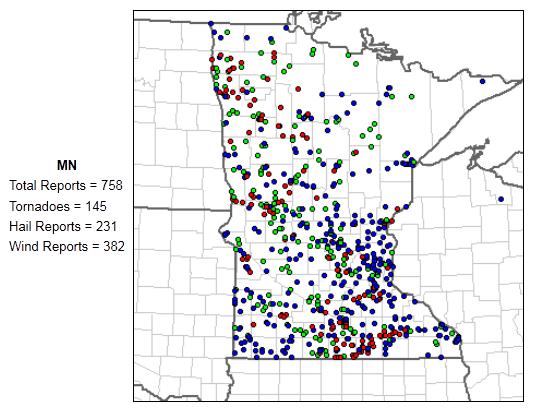
Incredible Numbers. For the last few weeks I've been going with a (113 number) for the total number of tornadoes in Minnesota during 2010. I just checked the SPC site and was amazed to see the number - revised upward - to 145. We lead the USA in confirmed tornadoes last year. I suspect another busy severe storm season, but hopefully we'll keep the tornado tally under 100. That would be nice. Note: SPC is still calling this a preliminary tornado count (but I can't imagine that they still have teams on the ground trying to pinpoint the number of 2010 tornadoes). This may wind up being the final number. Amazing.
Weather Monster. Dan Holliday captured this photo of the massive, 1 mile wide "wedge tornado" that swept through Wadena on June 17, 2010, one of 48 reported tornadoes that formed in the skies over Minnesota in one day.

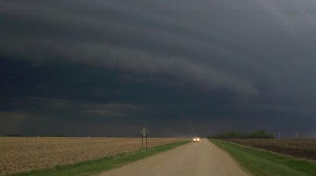
Shelf Cloud. Thanks to Chad Cummings for sending in this great example of a "shelf cloud" near Worthington, Minnesota.

President Declares A Major Disaster For Minnesota. Here's a recent press release from FEMA: "WASHINGTON -- The U.S. Department of Homeland Security's Federal Emergency Management Agency (FEMA) announced that federal disaster aid has been made available to Minnesota to supplement the state and local recovery efforts in the area struck by severe storms and flooding beginning on March 16, 2011, and continuing. Federal funding is available to state and eligible local governments and certain private nonprofit organizations on a cost-sharing basis for emergency work and the repair or replacement of facilities damaged by the severe storms and flooding in Big Stone, Blue Earth, Brown, Carver, Chippewa, Clay, Grant, Lac qui Parle, Le Sueur, Lyon, McLeod, Nicollet, Redwood, Renville, Scott, Sibley, Stevens, Traverse, Wilkin, and Yellow Medicine counties. Federal funding is also available on a cost-sharing basis for hazard mitigation measures statewide. Paul J. Ricciuti has been named as the Federal Coordinating Officer for federal recovery operations in the affected area. Ricciuti said that additional designations may be made at a later date if requested by the State and warranted by the results of further damage assessments."
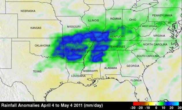
TRMM Maps A Wet Spring, 2011 For the Central U.S. The sensor's onboard NASA's TRMM satellite measured rainfall amounts from April 4 to May 4 as much as 20" more than usual - resulting in historic flooding on the Mississippi River: "NASA's Tropical Rainfall Measuring Mission satellite has been keeping track of the drenching rainfall that has been occurring in the central U.S. this springtime, and a newly created rain map from that data from April to May 4, 2011 shows those soaked areas. A combination of heavy rains and a large snow melt has put parts of the central U.S. at risk for record flooding this spring with several locations along the Mississippi already at or near record levels. One likely culprit is La Niña. Despite the fact that the current La Niña appears to be winding down, its effects in the atmosphere can persist for a while. Furthermore, although not every La Niña brings major flooding to the region, La Niña's are conducive for above-normal rainfall from East Texas and northern Louisiana up through Arkansas and the Tennessee and Ohio Valleys with below-normal rainfall across Texas, southern Louisiana and Florida."
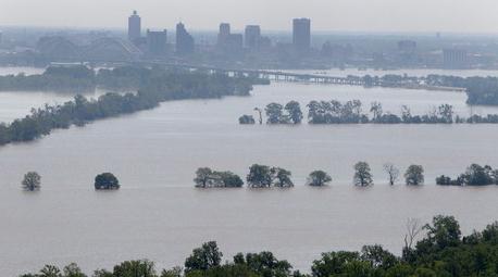
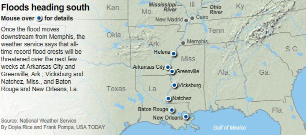
Across The Delta, Folks "Watch In Awe" As Rivers Rise. The scope of the flood gripping the Mississippi and its tributaries is truly awe-inspiring, the river 5-6 times wider than usual for early May. NPR has a good summary: "The destructive power of the "slow-moving wall of water" rolling south from Illinois to Louisiana, as NPR's Scott Neuman writes, is hard to capture in words. It's something that has to be seen to be fully understood. As NPR's Debbie Elliott told Morning Edition host Steve Inskeep today, in parts of Mississippi, folks are flocking down to the levees "to watch in awe" as waters rise in the mighty Mississippi River and its tributaries. Debbie, who's been reporting from the region for many years, says that in places such as Greenwood, Miss., "the water is higher than I have ever seen it."
After Cresting In Memphis, Flooded Mississippi River Takes Aim At Poverty-Stricken Delta. The Washington Post has the story: "VICKSBURG, Miss. — William Jefferson paddles slowly down his street in a small boat, past his house and around his church, both flooded from the bulging Mississippi River that has rolled into the Delta. “Half my life is still in there,” he said, pointing to the small white house swamped by several feet of water. “I hate to see it when I go back in.” The river was taking aim at one of the most poverty-stricken parts of the country after cresting Tuesday at Memphis, Tenn., just inches short of the record set in 1937. Some low-lying Memphis neighborhoods were inundated, but the city’s high levees protected much of the rest of Memphis. Downstream in Louisiana, inmates were filling sandbags to protect property in Cajun swamp communities that could be flooded if engineers open a spillway to protect the more densely populated Baton Rouge area. Fear was high among residents there. Jefferson’s Vicksburg neighborhood has been one of the hardest hit in the historic city that was the site of a pivotal Civil War battle. Jefferson refuses to leave, so he spends his days in the sweltering sun watching the water rise and sleeping in a camper at an intersection that’s likely to flood soon, too."
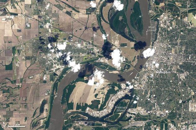
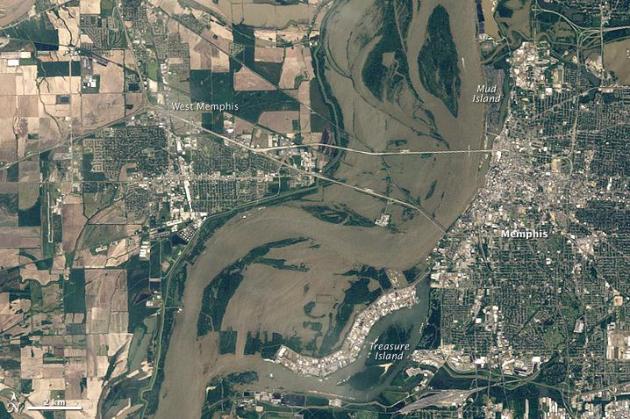
Memphis - Before And After The Great Flood of 2011. NASA's Earth Observatory has the startling details - 3 miles across at Memphis: "The Mississippi River reached 47.87 feet (14.59 meters) in Memphis, Tennessee, on May 10, 2011, according to the Advanced Hydrological Prediction Service (AHPS) of the U.S. National Weather Service. It was the highest water level for Memphis since 1937, when the river reached 48.7 feet (14.8 meters). Fortunately in 2011, an effective flood-control system helped save most residents from harm, according to The Commercial Appeal. The Thematic Mapper on Landsat 5 captured the top image on May 10, 2011, and the bottom image (showing non-flooded conditions) on April 21, 2010. Both images are natural color and show the area as it would look to the human eye. In May 2011, muddy water has pushed over the Mississippi’s banks both east and west of the normal river channel. Flood waters span the distance between Memphis and West Memphis, and also fill a floodplain extending to an industrial park northwest of Treasure Island. On May 7, authorities closed Mud Island River Park indefinitely due to flooded service roads that prevented emergency responders from reaching the park, The Daily News reported."
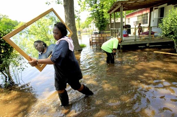
Missouri Farmers Return To Lands Ruined By Blown Levee. USA Today has the very sad details: "Missouri farmers, whose land was flooded when the Army blew a hole in a Mississippi River levee, are returning by boat and finding ruin. One farmer, Sam Barker, described coming upon the roofs of homes and barns and touching wet wood while bodies of deer and rabbit floated past. The widespread destruction includes everything from Indian mounds that are thousands of years old to family cemeteries, according to the farmer. It is just "a vast ocean of water," says Barker, 64, a third-generation farmer who lives in East Prairie, Mo. "Ninety-nine percent of the structures in that spillway have water up to the eaves of the roof." He adds, voice shaking, "In my lifetime, I have never suffered like this." Barker is one of the farmers who own or work 130,000 acres of southeast Missouri farmland flooded last week after the Army Corps of Engineers blasted holes in a levee to spare Cairo, Ill., a city of 3,000, from floods. Mississippi County, Mo., Sheriff Keith Moore allowed farmers to board boats this week to inspect their properties."
Top 10 Historic U.S. Floods. Time Magazine has a great overview of flooding in this post. There's every indication that the current scope of flooding on the Mississippi River will wind being greater than anything since 1937, possibly the Great Flood of 1927 in some areas: "Date: April-May 1927/ Significance: Most destructive river flood in the history of the U.S.; 500 killed; 600,000 homeless. Holmes says: The sheer landmass involved in this flood makes it incredibly noteworthy. Across Illinois, Missouri, Kentucky, Tennessee, Arkansas, Mississippi and Louisiana, some 16 million acres of land (26,000 square miles) were inundated with water from the mighty Mississippi. At Vicksburg, Mississippi, alone, the river was 80 miles wide. This flood shifted the influence of flood policy in the U.S., which is still impacting us today. Everything — our levee policies, the way we engineer all of these things — was built out of what people learned from the 1927 flood."
Question Submitted to the SC Times in St. Cloud: "I have a question for Paul Douglas. We are planning a road trip to Yellowstone this summer. If we encounter severe weather/tornado warnings, where is the safest place to go when you're traveling in a motorhome? "
Answer: "Thanks for the e-mail – I’m very jealous of your upcoming Yellowstone Road Trip! In the (highly unlikely) event you were to encounter a tornado (or even straight-line winds) my best advice would be to pull over at a rest stop, store, any building will offer more protection than an RV. When you stop for the night make sure there’s a reinforced shelter within a 1-2 minute dash of your camp site. In fact I would probably seek out campgrounds that do have storm shelters, or a reinforced bathroom nearby. Again, the odds are very much in your favor – chances are your trip will come off without a (weather) hitch. But it’s always good to be a little paranoid, ask yourself where you would go if threatening weather approached. A building (of any kind) will be the best bet if high winds approach."
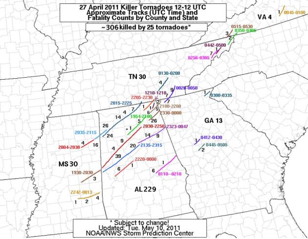
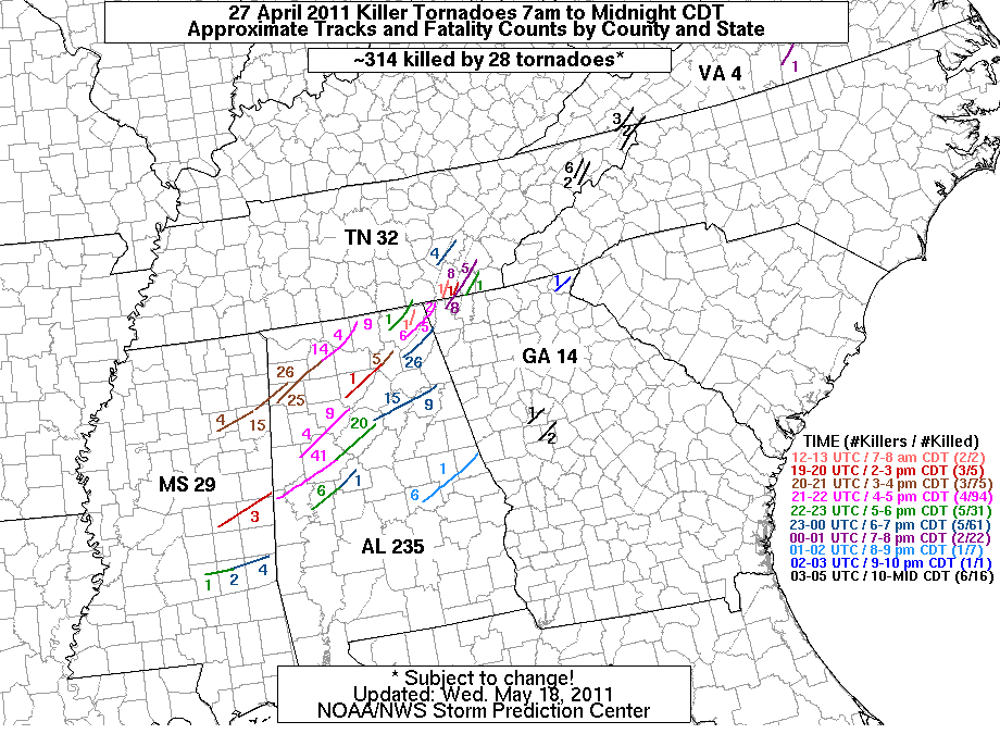
Long-Tracked (Killer) Tornadoes. Dixie Alley is actually (statistically) more dangerous that tornado alley, for a variety of reasons: higher population density - it's harder to see/track the tornadoes once they form, few people have basements or underground shelters, a higher percentage of the population lives in mobile homes, more vulnerable to tornadic winds. According to SPC 306 people were killed by 25 separate tornadoes on April 27.
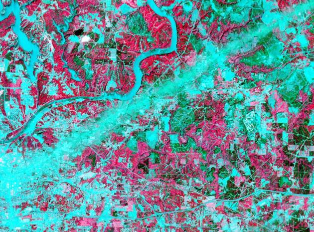
NASA Satellite Observes Damage Path From April Tornadoes. Keep in mind some of these tornadoes were 1/2 to 1 mile wide. An EF-4 tornado (with 150-180 mph winds) is capable of scraping homes down to foundation - precious little left. You can see that there isn't much left (that's recognizable) in the damage swath. More from NASA: "Recent images of the April 27 storm damage path have been captured by NASA's Terra satellite, part of NASA's Earth Observing Satellite system, or EOS. An instrument aboard Terra, called Advanced Spaceborne Thermal Emission and Reflection Radiometer or ASTER, captured the images show the scars from the outbreak. ASTER combines infrared, red, and green wavelengths of light to make false-color images that distinguish between water and land. Water is blue. Buildings and paved surfaces are blue-gray. Vegetation is red. The images to the right are from an observation that occurred on May 4, 2011 at 11:45 A.M. local time (1645 UTC), near Tuscaloosa, Ala. The physical principle guiding the use of satellite data to detect tornado damage is based on the premise that the strong winds associated with a tornado will change the physical characteristics of the surface in such a way as to alter the visible and infrared energy reflected. These characteristics could be a change in the orientation of surface features, such as the complete destruction of a house in a residential area, the snapping of trees in a forest region, the uprooting of crops in an agriculture area, or minimal damage to grassland in a pasture or field."
Family Ties Itself To Trees To Survive Tornadoes. This is a new one - but (the more I thought about it), not a bad option, especially for people who live in mobile homes. The problem and inherent danger of doing this: not having enough time to actually get this done before the tornado strikes, and tying YOURSELF to a tree? Not sure about that. The other big obstacle: being hit by flying debris while you're clinging to a tree. The mind-boggling story from MSNBC: "LOUISVILLE, Ky. — A rope and a cluster of trees — that's what an Alabama family says saved them from the tornadoes that struck the state. Larry White just returned to Louisville from helping his sister and her family recover from the Alabama tornadoes that blew their home away. When White watched the path of the now famous black twisting cloud on TV, he could see it heading straight toward Wellington, Ala., the home of his sister, Tammy Hardy. "As it came on through, you could see the magnitude, and how wide it was. Just a big cloud on the ground,” White told NBC station WLKY. “And I told my wife, I said, ‘It's headed right to my sister's place.’ ”By the time he called, Hardy, her husband, two sons, their wives and her six grandchildren had already lost power to their homes and headed for cover. "I didn't know if we was going to live through it. I thought this might be when I die,” Hardy said. After their power went out, Hardy said, it was only minutes before the tornado bore down on their small farm. Hardy said as she heard their trailers ripping apart, they had no time to think. Her son quickly came up with a plan. “We put the kids in the middle of the four little trees and the rest of us gathered in around them in a huddle,” Hardy said.

Fishing Opener Trivia - Courtesy of the MN State Climatology Office. Check out the details for yourself here.
Overview: "Minnesota's Fishing Opener weather is typified by partly cloudy to cloudy skies, morning temperatures in the low 40's, and afternoon temperatures climbing to near 70. Three out of four years are free of measurable precipitation. A trace of snow has been reported in northern Minnesota on at least four of the last 56 fishing openers. On at least three occasions, some lakes were still frozen for the opener. Generally there is enough wind to be felt on the face, maybe enough to 'fly' a flag. Weather on Minnesota fishing opener dates is highly variable."
Cloudcover: "Statewide, less than one year in five offers totally clear skies. The average amount of cloudiness lies near that fuzzy boundary between 'partly cloudy' and 'cloudy', but over half of the dates were classified as cloudy."
Temperatures: "The average early morning temperature varies from the high 30's in the northeast to the high 40's along the southern border. The average afternoon temperature generally ranges from the mid 60's along the northern border, to the low 70's in the extreme south. Along the shore of Lake Superior, highs are held in the mid 50's."
Rain: "Three quarters of past opening days have been free of measurable precipitation. Two thirds of the fishing openers have been free of any precipitation, measurable or not."
Snow: "Snowfall has generally has been limited to traces. Traces of snow were officially recorded in 1963 and 1993 at International Falls, and in 1968 at St. Cloud. A tenth (.1) of an inch fell at International Falls in 2000."
Winds: "Average daily wind speeds generally range between 8 and 15 miles per hour. This range can is described as 'wind felt on face ...' to '... wind extends light flag'. The predominant wind direction is split fairly evenly between blowing from the northwest, south, and east."
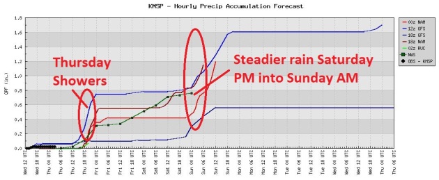
A Soggy Holding Pattern. Models print out .20 to .30" rain showers during the midday and afternoon hours today (too cool and stable aloft for anything severe). Heavier, steadier rains may arrive, sweeping in front Wisconsin and northern Minnesota late Saturday and Saturday night - puddles lingering into midday Sunday.
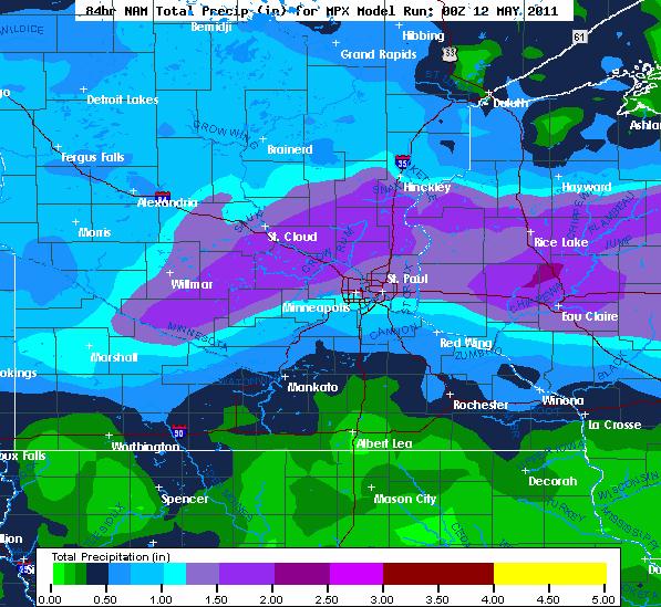
(Very) Green Lawns. The latest NAM model prints out 1-1.5" of rain across much of central and east central Minnesota into central Wisconsin, most of that heavy/steady rain coming late Saturday and Saturday night. Yep, looks like a weekend.
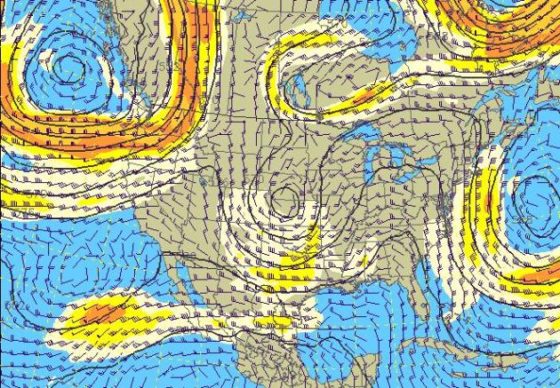
Omega Block. A storm stalled in the Atlantic is acting like a giant atmospheric road-block, forcing a storm to stall over the central U.S. - prolonging our rain into the weekend. Lousy timing. The pattern finally breaks down next week, becoming more "progressive", weather systems moving from west to east at 20-25 mph, which is typical for mid May.
Saturday Puddles. A stalled storm over the Great Lakes will continue to rotate showery rains in (from the east) into Saturday, the heaviest/steadiest rains probably holding off until late Saturday and Saturday night. The NAM model above is valid 1 pm Saturday.
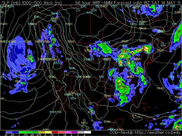
Sunday Blues. An unusually cold swirl of air rotating over Minnesota will keep our skies unstable and showery into at least the midday hours Sunday. Skies may clear (slowly), from north to south, later in the day Sunday, especially over the northern half of Minnesota. I can't promise it - but the weather may improve up north later in the day Sunday. The NAM map above is valid 7 am Sunday.
Brett Favre Helping Residents In Alabama Town Devastated By Tornado. USA Today has the story: "Last week Brett Favre said he was "starting a new career." But first, he is focused on more pressing business. Favre is heading to Hackleburg, Ala., to assist tornado victims in the devastated town. The deadly tornadoes that swept across the south in late April all but obliterated Hackleburg, a town of 1,500 people where the main employer was a Wrangler distribution center. About 75% of the town is gone with the remainder heavily damaged. Favre serves as a Wrangler spokesman and was active along with late NFL QB Steve McNair in assisting Mississippi school children and families uprooted by Hurricane Katrina. His agent, James "Bus" Cook said of Favre's attitude: "He said, 'I don't mind signing autographs. But if I go up there, I'm going to bring help. I'm going up there to work.''' Cook also said Favre would welcome the chance to work with another of his clients, Cam Newton, the QB the Carolina Panthers selected No. 1 overall in the NFL draft last month." (photo above courtesy of Rogelio Solis from the AP).
How Many Hurricanes This Year? Our partner and client, Earth Networks, formally known as WeatherBug, has just released their forecast: "GERMANTOWN, Md.--(BUSINESS WIRE)--Earth Networks™, the owner of the WeatherBug® brand and operator of the largest weather observing and lightning network, releases its 2011 Atlantic Hurricane Season Forecast today. The WeatherBug Meteorology team calls for an above-average season, which runs from June 1 to November 30 every year in the Atlantic Hurricane Basin that consists of the Atlantic, Caribbean Sea and the Gulf of Mexico.
The Earth Networks - WeatherBug Atlantic Hurricane Season Forecast 2011 includes the following predictions:
- Overall Outlook: The Atlantic hurricane season will be above average, but less active than last year. A total of 13 to 14 named storms are expected to form in the Atlantic Hurricane Basin. The long-term average is about 10 storms.
- Hurricanes: Seven to eight of these storms will become hurricanes, and four are predicted to become major hurricanes with possible winds in excess of 111 mph. The long-term average is about six hurricanes and three major hurricanes.
- U.S. Landfall Threat: An above-average forecast does not necessarily mean there is a greater likelihood of a hurricane landfall in the U.S. Last year’s hurricane season was much above normal, but no hurricanes made landfall in the U.S.
By comparison, The Colorado State University tropical forecast team on April 6 predicted 16 tropical storms, nine hurricanes and five major hurricanes this year. The National Oceanic and Atmospheric Administration (NOAA) hurricane forecast will be issued May 19.
Why the above-average outlook? Earth Networks Chief Meteorologist Mark Hoekzema explains, “While water temperatures in the Atlantic Ocean are warmer than average in key tropical cyclone development areas, they are not as warm as last year. La Niña conditions, which usually favor the formation of tropical storms, are forecasted to weaken throughout the summer. Neutral conditions are expected during the prime hurricane months from August through October. However, tropical systems can form at any time during the season.”
Additional contributors to this above-average forecast include a recent historical pattern of 12 active hurricane seasons. Previous years with similar climate conditions have also been more active than average. Similarities of this year’s weather to years such as 2008 and 1996 also point toward an increased potential for a land-falling hurricane to impact the U.S. this year."
Least Air Pollution In The U.S. : 10 Cleanest Cities. Huffington Post has the story: "Did your city make the list? The American Lung Association (ALA) has released their annual report, State of the Air (SOTA) 2011, highlighting which cities are the cleanest for ozone pollution, short-term particle pollution, and year-long particle pollution. This slideshow highlights the ten cities ranked in the SOTA 2011's list of "Cleanest U.S. Cities For Year-Round Particle Pollution" Honolulu, HI and Santa Fe, NM are the two metropolitan areas that made it onto all three of the cleanest cities lists from 2007 to 2009. Reports of cleaner air have been showing up repeatedly in some monitoring data, and the ALA credits these pollution reductions in part to both improved emissions from coal-fired power plants and the transition to cleaner diesel fuels. That said, over half of the U.S. still suffers from pollution levels that can be dangerous to breathe. Click here to see the 10 U.S. cities with the deadliest air pollution. Click here for more information on the SOTA 2011 report, or visit the SOTA website to view all three lists of clean cities."
Is San Francisco Next? The first company that can refine the black art of earthquake prediction will (instantly) worth a few hundred billion dollars. Geologists and seismologists are making progress, but huge questions remain, including the liability issue: if you predict a massive quake and nothing happens, costing a city billions of dollars, who pays? The Atlantic has an interesting article: "Some established geophysicists insist that all earthquakes are random, yet everyone agrees that aftershocks are not. Instead, they follow certain empirical laws. Stein, Lin, and their collaborators hypothesized that many earthquakes classified as main shocks are actually aftershocks, and they went looking for the forces that cause faults to fail. Their work was in some ways heretical: For a long time, earthquakes were thought to release only the stress immediately around them; an earthquake that happened in one place would decrease the possibility of another happening nearby. But that didn’t explain earthquake sequences like the one that rumbled through the desert and mountains east of Los Angeles in 1992. The series began on April 23 with a 6.2 near the town of Joshua Tree; two months later, on June 28, a 7.3 struck less than 15 miles away in the desert town of Landers. Three and a half hours after that, a 6.5 hit the town of Big Bear, in the mountains overlooking the Mojave. The Big Bear quake was timed like an aftershock, except it was too far off the Landers earthquake’s fault rupture. When Lin, Stein, and Geoffrey King of the Paris Geophysical Institute got together to analyze it, they decided to ignore the distance rule and treat it just as a different kind of aftershock. Their ensuing report, “Static Stress Changes and the Triggering of Earthquakes,” became one of the decade’s most-cited earthquake research papers."
"Tokyo is more likely, says a scientist whose work on aftershocks may revolutionize quake forecasting."
Congress Hears From Apple & Google On Privacy. It turns out all those "free" services from the brands we know and trust (?) aren't so free after all. They're mining our personal data, attempting to target ads, and privacy concerns are growing, according to this story in the New York Times: "Saying there has been a fundamental shift for cellphone users in determining “who has their information and what they’re doing with it,” Senator Al Franken, a Minnesota Democrat, called a Congressional hearing today to question executives from both Google and Apple on data location and mobile devices. The hearing was the first for the newly formed Senate Judiciary subcommittee on privacy, technology and the law, led by Senator Franken. Lawmakers on the panel all acknowledged that mobile devices and location-based technology were useful for individuals and businesses, but cited growing concerns about how much data was being shared with third-party companies, the potential for data security breaches and the threat of criminal activity, like stalking, as issues affecting mobile privacy. Regulators also raised concerns about the use of location-based technology by children who use smartphones and other devices. “These breaches of privacy can have real consequences for real people,” Mr. Franken said. The hearings follow a recent series of reports that Apple collected user location data from its iPad and iPhone devices and Google from its Android smartphones. Both Google and Apple have said the location data they collected was not personally identifiable and was used to send users better advertisements and promotions when they opted to receive certain services."
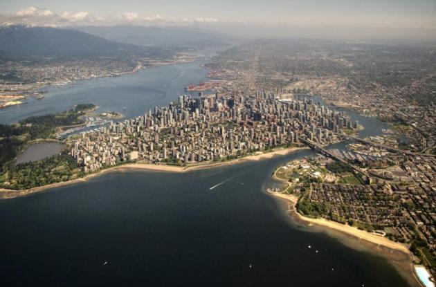
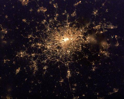
Photo Essay: The World's Biggest Cities From The Air. A unique perspective, courtesy of Matador Travel.
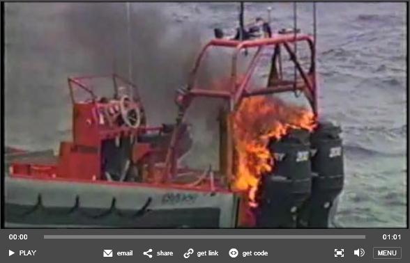
Video: Navy Laser Sets Ship On Fire. I'm sure glad these guys are on our side. Wired has the (remarkable) details: "With clouds overhead in the salty air, irritable Pacific waves swelled to up to four feet. Perfect conditions, in other words, for the Navy to fry a small boat with a laser beam — a major step toward its futuristic arsenal of ray guns. Researchers mounted the Maritime Laser Demonstrator, a solid-state laser, aboard the USS Paul Foster, a decommissioned destroyer. Off the central California coast near San Nicholas Island on Wednesday, the laser fired a 15-kilowatt beam at an inflatable motorboat a mile away as both ships moved through the sea. As the above video shows, there was a flash on the boat’s outboard engines, igniting both of them in seconds, and leaving the ship dead in the choppy waters. All previous tests of the laser have come on land — steady, steady land — aside from an October test of the targeting systems. But for the first time, the Office of Naval Research has proven that its laser can operate in a “no-kidding maritime environment,” says its proud director, Rear Adm. Nevin Carr. “I spent my life at sea,” Carr says in an interview with Danger Room, “and I never thought we’d see this kind of progress this quickly, where we’re approaching a decision of when we can put laser weapons on ships.” Fewer than three years after the Navy awarded Northrop Grumman a contract worth up to $98 million to build the Maritime Laser Demonstrator, it’s proven able to cause “catastrophic failure” on a moving target at sea the first time out, says Quentin Saulter, one of ONR’s top laser gurus."
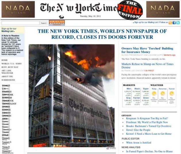
Breaking: New-Media Parody Site Hits Internet. Wired Magazine has the details. And no, it's not true (about the New York Times). "Big fan of media mockery but getting burnt out on Gawker and The Onion? Well, we have news for you. Please welcome to the internet The Final Edition. The news parody site launched Tuesday with a spoof of The New York Times website, which should come as no surprise. The Final Edition was founded by Tony Hendra, the National Lampoon alumnus and This Is Spinal Tap actor who helped create parody newspaper Not the New York Times more than three decades ago. “We thank The New York Times from the bottom of our hearts for being so ridiculously easy to parody,” Hendra said in an e-mail to Wired.com. Following Tuesday’s Times send-up, The Final Edition’s mission is “to save humanity from the deadly worldwide scourge of funny cat videos,” he added."
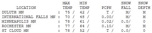

Wednesday Numbers. After a wet start skies cleared, it actually turned into a beautiful spring day. Highs ranged from a chilly 54 at Grand Marais to 75 at Duluth, 78 at St. Cloud and the Twin Cities, a balmy 82 at Hibbing. I know - very odd.
Paul's SC Times Outlook for St. Cloud and all of central Minnesota:
TODAY: Showery rains, thunder? Winds: N 10-15. High: 67
THURSDAY NIGHT: Showers linger - damp breeze, turning cooler. Low: 47
FRIDAY: Unsettled, more showers and sprinkles. High: 56
SATURDAY: Waterproof jackets for Fishing Opener. Showers likely, unseasonably cool. Winds: N 10-15. High: 51
SATURDAY NIGHT: Periods of rain - still raw. Low: 41
SUNDAY: Periods of rain. PM clearing north. Choppy on area lakes. Winds: NE 10-20. High: 55
MONDAY: Sunny & nice. Naturally. Low: 44. High: 63
TUESDAY: Blue sky, beautiful spring weather! Low: 48. High: 69
WEDNESDAY: Clouds increase, shower risk. Low: 51. High: 67
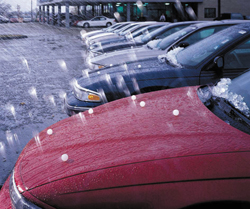
Wearing My "Hail Helmet"
Welcome to the United (Severe) States of America! It's safe to go outside, as long as you're wearing a helmet, and can reach a basement in 60 seconds or less. No wonder we're all suffering from AWP, acute weather paranoia.
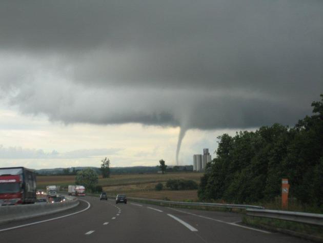
Tuesday's evening's Twins game had to be halted for 2" hail. Ushers were wearing batting helmets ! to keep from being pelted. WeatherNation meteorologist Todd Nelson was on his deck in St. Michael when a tornado (first of the year) touched down directly in front of him. Todd calls this "deck chasing." Tuesday's "supercells" spawned tennis ball size hail, a reminder that severe storm season is upon us.
The good news: the atmosphere is cooler & more stable, no more quality time curled up in the basement anytime soon. The bad news: an "Omega Block" means that storms have stalled, and showers will linger into the weekend. In fact a stagnating storm over the Upper Midwest may "retrograde", drifting toward the WEST, insuring a sloppy Fishing Opener with highs stuck in the 50s. At least it won't snow. It won't be a steady/heavy, all-day rain - but take a warm, waterproof jacket.
Meanwhile, I'm writing a new business plan. "Hail Helmets". It's 'gonna be big!
Study: No Global Warming In North America (Say What?) "We report/confuse/obfuscate/deny - you decide." Media Matters has the story: "Got that? The globe is not warming in North America -- just like the United States doesn't have an unemployment problem in North Dakota. What's more is that the study Fox Nation refers to doesn't actually contend that there have been no global warming effects in North America. Here, Fox is echoing an Ottowa Citizen headline which stated: "Climate change hardly visible in North America: Canada U.S. buck trend, scientists say." This too is a misrepresentation of the research. In fact, the study examined only crop-producing regions and only during the growing seasons of corn, rice, maize, and wheat.The research indicated that those specific regions in the U.S. have not seen the same warming trend evident in global average temperatures over the past 30 years. (Indeed, no climate scientist would say the planet is expected to warm uniformly). Stanford's David Lobell, one of the authors of the study, explained in an email that he was "disappointed" in both the Fox Nation and Ottowa Citizen coverage, which "do not accurately portray our findings." He added: "The study was only focusing on one aspect of climate change (impacts on agriculture) and looked only in the parts of the countries where and times of year when certain crops are grown. for example, if one looks at winter temperatures in these regions, it would paint a different picture. also, the lack of trend in any one region has very little bearing on whether global warming is happening."
Climate Quote(s) Of The Day. "We've pushed the environment to the point that it's changing in ways that rewrite the basic rules of the game we thought would never change. Many of the assumptions we made and still make in locating things like buildings, power plants, farms, and entire cities held true for decades or centuries, but now they're changing. Suddenly, we have power plants shut down for weeks to months at a time because of a lack of cooling water, coastal populations threatened by SLR, farmland taken out of production due to water shortages or flooding or heat waves, etc. Adaptation is, to a large degree, a race between the changing environment and our ability and willingness to change our infrastructure."
- Lou Grinzo. Lou Grinzo is a writer and researcher residing in Rochester, NY. He blogs at The Cost of Energy (http://www.grinzo.com/energy/)
__________________________________________________
"The earth is round, smoking is linked to lung cancer, gravity makes things fall, and humans are warming the planet. Scientists strongly agree on all of these."
- Scott Mandia, Professor of Physical Sciences. Suny Suffolk College Of New York
Scientists, Farmers To Study Climate Change. The Seattle Times has the story:
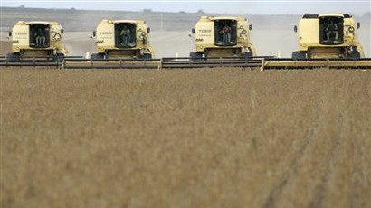
"SPOKANE, Wash. Farmers and scientists in the inland Northwest are launching a $20 million study on how climate change will impact agricultural practices. Nearly 100 researchers and farmers from across the region met Monday at the University of Idaho, where the five-year research program is starting, The Spokesman-Review reported. "Climate change is one of the challenges that faces the sustainability of agriculture in this region," said UI professor Scott Eigenbrode, who is leading the project. Funding for the study comes from the U.S. Department of Agriculture. Temperatures in the area have already risen about 1.8 degrees on average in the past century, and the Intergovernmental Panel on Climate Change is predicting they will increase another 3.6 degrees by 2050, Eigenbrode said. Winter precipitation is predicted to increase by 5 percent, but summer rainfall could drop by 5 to 20 percent, he said. Warmer summer temperatures could spell problems for grains and other crops that will face increased heat and water stress. Pests such as the cereal leaf beetle, Hessian fly and aphids could become bigger problems in a warmer climate, he said. Pathogens carried by aphids might also be aggravated."
Lies, Damn Lies, And Statistics. This post from Stephan Lewandowsky is from January, courtesy of the ABC Network in Australia, but it resonates today: "Single events carry little information — a single heatwave by itself tells us little more about the climate than a single blizzard. (Actually, forensic statistical techniques exist that permit more robust interpretation of single extreme events, especially when they are virtually unprecedented such as the heat on Victoria’s Black Saturday, but that is carrying us too far afield). Notably, the very same extreme observations can be legitimately revealing if they are considered not as anecdotes but as data. That is, instead of cherry picking one or the other observation, a proper statistical treatment requires that all extremes be considered together. When this is done, the picture is unequivocal: The last 5 decades have seen an inexorable decrease in the number of record cold days and an equally steady increase in the number of record hot days — in Australia, there are now more than two record hot days for every one record cold day. If the climate weren’t changing, there’d be the same number of each. Yes, there are still record cold days, in Australia as well as in England or India or Mongolia — but when all the data are considered, heat records far outpace cold records. Indeed, in 2010, nearly 20 countries broke all-time heat records whereas at most one broke an all-time cold record (as of November, subject to confirmation by the World Meteorological Organization). The real data show 20 heat records to 1 cold record. That is data, not an isolated anecdote or a silly picture."
Stephan Lewandowsky is a Winthrop Professor and Australian Professorial Fellow at the University of Western Australia and an award winning teacher of statistics..
Could Climate Change Be A Good Thing? For 30 years climate scientists have been saying that there will be benefits to a slowly warming climate: longer growing season, opening up parts of Canada (and Siberia) to farming. But the downside is considerable: more frequent/intense droughts, floods, a possible increase in the severity of storms - more pests, stresses on crops, the list goes on. The U.K.'s Guardian has the glass-half-full story: "A changing climate isn't inherently bad, and commentators who are sceptical about the risks posed by global warming often point to the benefits that higher temperatures could bring – such as longer growing seasons in cool countries and more efficient shipping routes through an ice-free Arctic. Even some of those who are concerned about climate change occasionally highlight opportunities that it presents, whether that's a boost to UK tourism or a shake-up of global politics. Certainly it's true that a warmer world could benefit certain people, species, regions and industries – at least for a period. However, any such benefits need to be seen in the context of a number of serious and widespread negative consequences that scientists have warned the world to expect: things such as rising sea levels, an increase in the number of people exposed to devastating droughts and floods, and a potentially massive increase in extinction rates. That explains why world's most prestigious scientific bodies stated in 2009 that: "It is essential that world leaders agree on the emission reductions needed to combat negative consequences of anthropogenic climate change". Of course, any comparison of specific positive and negative impacts is complicated by the fact that the effects of climate change will vary according to both location and time. For example, the science suggests that global agricultural productivity may increase during the first three degrees Celsius of warming, driven by gains in relatively wealthy high-latitude regions. During that time, however, productivity looks likely to fall in the poorer tropical areas, followed by a drop in global food production if the temperature warms by more than 3C – something that could be expected to put a huge strain on a world population expected to exceed nine billion by the end of the century."
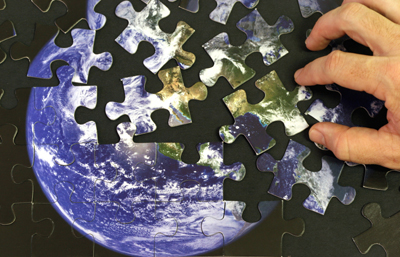
Confronting The "Anthropocene." Dot Earth's Andrew Revkin has an interesting post about this new era we're living in. For the first time man has the ability to change the composition of the Earth itself (and its atmosphere): "LONDON — I’m participating in a one-day meeting at the Geological Society of London exploring the evidence for, and meaning of, the Anthropocene. This is the proposed epoch of Earth history that, proponents say, has begun with the rise of the human species as a globally potent biogeophysical force, capable of leaving a durable imprint in the geological record. There’s more on the basic concept in National Geographic and from the BBC. Paul Crutzen, the Nobel laureate in chemistry who, with others, proposed the term in 2000, and Christian Schwägerl, the author of “The Age of Man” (German), described the value of this new framing for current Earth history in January in Yale Environment 360: "Students in school are still taught that we are living in the Holocence, an era that began roughly 12,000 years ago at the end of the last Ice Age. But teaching students that we are living in the Anthropocene, the Age of Men, could be of great help. Rather than representing yet another sign of human hubris, this name change would stress the enormity of humanity’s responsibility as stewards of the Earth. It would highlight the immense power of our intellect and our creativity, and the opportunities they offer for shaping the future. [Read the rest.]"

Justifying $15 Trillion For Renewables. Theenergycollective.com has some food for thought about the prospects for green energy with this editorial: "Yesterday I received a joint press release from a group of renewable energy trade associations. It touted a new report from the UN Intergovernmental Panel on Climate Change (IPCC) on the potential growth of renewable energy by 2050. The report has already garnered an impressive array of headlines, such as "Renewable Energy Can Power the World" and "Renewable Energy Key to Solving Climate Change". The headline from the Financial Times was characteristically more concrete, "World faces $15,000 bn renewable energy bill." Unfortunately, although the final report, rumored to run 1,000 pages, might support all of those conclusions when it is issued at the end of the month, the 25-page "Summary for Policymakers" falls far short of inspiring such confidence. Heaven help those policymakers if the summary is all they actually read. I'm not even sure if "read" is even the correct verb to apply to this document. Once I got beyond the introductory paragraphs it seemed to degenerate into jargon and bureaucratese that was very hard to parse into plain meaning. The report's genesis as the product of pure consensus is readily apparent. Or as Andy Revkin of the New York Times' Dot Earth blog kindly put it, "it doesn't take readers much beyond what is already well established." That's a shame, because we don't need yet another report telling us that we are swimming in enough renewable energy to power our civilization umpteen times over, if we can merely muster the willpower to reach out and tap it. What we urgently need is a roadmap that describes a path--or preferably several possible paths--through the brambles that separate the energy status quo of 2011 from its ideal low-carbon state of 2050. For example, we need to understand just how renewables will supplant the petroleum that currently provides around 94% of all transportation energy, at least in the US. That demand might be met by biofuels, although the report points out that the first-generation biofuels that supply nearly 3% of global road transport fuel today, but are still the only kind available on a commercial scale, have serious shortcomings. Closing the gap between 3% and 94% would require a true revolution in next-generation biofuels from sources such as cellulose and algae, yet after reading the Summary for Policymakers we are no wiser about when and how this will occur. I might note that such developments are rarely amenable to precise timetables, as the EPA is learning to its chagrin."

Climate Rap - Scientists Fight Back. New Zealand's Hot Topic has the story (and video, rated R for salty language). Yes, climate scientists are increasingly frustrated by the current state of affairs: the denial, the Oil Money funding "research" that calls their peer-reviewed findings into question: This is a preview of a section of tonight’s Hungry Beast show (Wikipedia explains) on ABC in Australia — I’m A Climate Scientist — a rap attack on climate denial. Opening lines: Slightly not safe for work, or if you are sensitive to rude language. Full lyric at Youtube. But hilarious, and well worth watching. I’d pay good money to see a version with Gavin Schmidt, Mike Mann, Kevin Trenberth and Phil Jones. Or do I mean “Bad”? Hat tip: John Cook via @skepticscience."
No comments:
Post a Comment