"
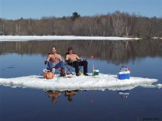
Redneck Ice Fishing."
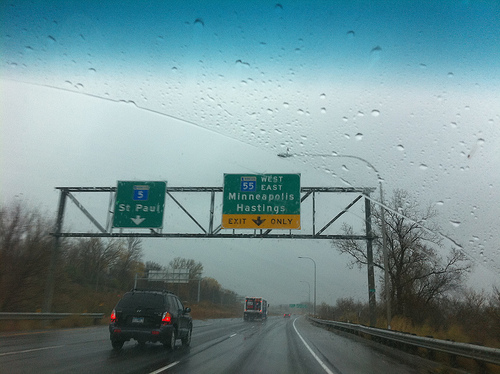
Fishing Opener Update. It won't snow. There are no ice-covered lakes up north. No gale-force winds on Mille Lacs, Gull or Leech Lake. Saturday will be fairly uncomfortable, but skies clear on Sunday with enough sun for a respectable sunburn.
Brainerd and Alexandria Lakes Area:
Saturday: Periods of rain. Temperatures: 43-54 F. Winds: N 10-20. Barometer: steady.
Sunday: Mix of clouds and sun. Temperatures: 42-61 F. Winds: NE 10-20. Barometer: rising.
.22" rain predicted for Saturday and Saturday night.
Sunday: nicer day of the weekend (by far).
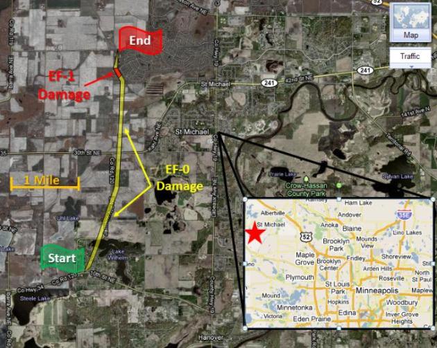
EF-1: strength of the tornado that hit the St. Michael area Tuesday evening (details below).
$4 billion: early estimates of flood damage from the Mississippi River flooding.
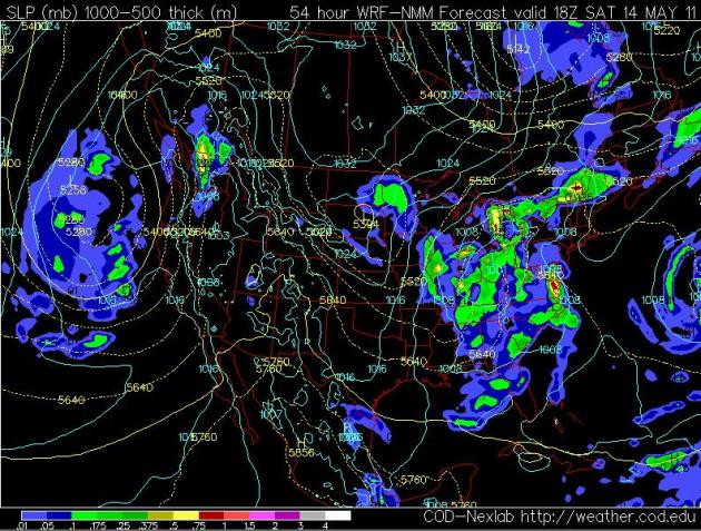
Saturday Puddles. A stalled storm over the Great Lakes will continue to rotate showery rains in (rotating in from the north/east) into Saturday. This probably won't be a steady rain, but a few hours of showers are likely. The NAM model above is valid 1 pm Saturday.
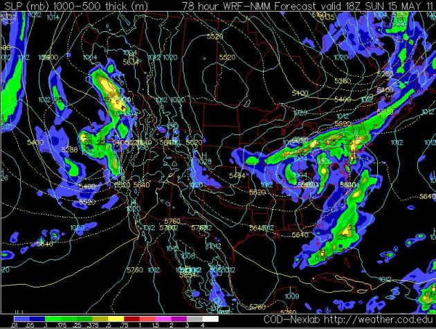
Sunday Lives Up To Its Name.The latest 12z Thursday NAM looks MUCH more encouraging for Sunday plans. A Canadian high should be string enough to push the showers to our south, into Iowa, with enough sun for upper 50s (north) and low 60s (south). It will still be on the cool side, but in the sun it should feel great out there by afternoon. You might want to be optimistic and take along some sunscreen for Sunday if you're going to be out on the water.
St. Michael Tornado Details. Tuesday evening's touchdown in St. Michael was, in fact, the first confirmed tornado of 2011 in Minnesota. The local NWS office has a
link with more details, including the atmospheric dynamics that helped to spin up the small tornado:
"The tornado touched down just east of the intersection of County Roads 34 and
120 and tracked north-northeast for 3.1 miles. The only time it deviated from this
track was toward the end of its existence, when it made a slight turn toward the
north-northwest and intensified. After hitting the house, it turned back toward the
north-northeast and quickly dissipated. The tornado was narrow, only 75 feet wide
at most, and it was often narrower than 75 feet.
Most eyewitnesses did not realize there was a tornado, because they did not see
the debris swirling at ground level and the funnel did not extend all the way to the
ground. It turns out that the condensation funnel only extended downward for some
distance, then it appeared like there was nothing, then the debris at the surface.
However, the violently rotating wind made it all the way to the ground but there
was not enough humidity in the few thousand feet above the ground to condense
and create the cloud that makes the tornado visible."
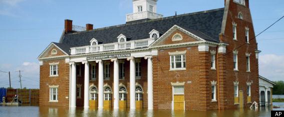
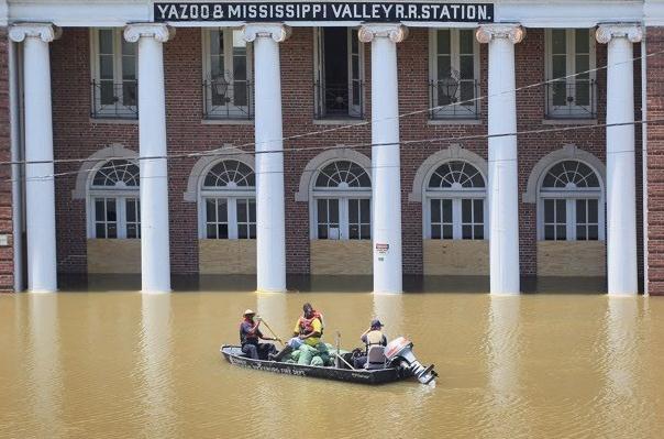
Mississippi River Flooding Reaching Historic Levels. Huffington Post has the
latest on a slow-motion natural disaster, weeks in the making: "
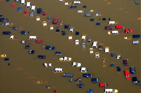
In one of the worst cases of flooding since the Great Depression, the bulging, swollen Mississippi River is overflowing in record proportions, blanketing thousands of square miles across Arkansas, Tennessee and Mississippi, negatively impacting the environment, and causing billions of dollars in damage. After weeks of intense rainfall, the water level is breaking records across Mississippi. In Natchez, Miss., the water now stands at 58.3 feet, shattering the 1937 watermark of 53.04 feet. And the National Weather Service says that the flooding is just getting started. While residents scramble to reach higher ground, the rest of the country has focused on the economic and environmental impacts of this last round of severe weather, which comes in the wake the devastating tornadoes that swept the Southeast two weeks ago. The water is flooding some of the most fertile areas in the country, so damages to agriculture alone could easily top $2 billion, according to estimates by economist John Michael Riley, a professor in the department of agricultural economics at Mississippi State University. “Crop lost estimates are definitely around $800 million for Mississippi alone,” Riley said. To that $800 million, Riley added another $500 million in estimated losses in Arkansas, and several hundred million more caused by flooding in Louisiana, Missouri and farmland north of Memphis in Tennessee."
Mississippi Flood Damage Could Reach Billions. USA Today has a
story that puts the flood into stark perspective: "
Flooding along the Mississippi River, already swamping cities and farmland and crimping business from river barges to casinos, could cost billions. Although economists say it's too early to tell how much damage the Mississippi and its tributaries might wreak along the states in their path, economist John Michael Riley estimates damages could run up to $4 billion "It's not like a tornado disaster, where it's over and the damage can be assessed," says Jon Moen, who chairs the economics department at the University of Mississippi. "But we're sure it's going to have a pretty big impact." Losses in Arkansas are estimated at more than $500 million, according to the state Farm Bureau. In Memphis, where the river crested Tuesday, damage was estimated at $320 million. Agricultural losses in Mississippi, including grain and catfish farms, could hit $800 million, says Riley, a commodities specialist at Mississippi State University. The impact on the broader U.S. economy remains unclear. Conrad DeQuadros, senior economist with RDQ Economics, notes jobless claims could rise if flooding keeps workers idle, while manufacturing could suffer if shipping lanes are disrupted on the Mississippi."
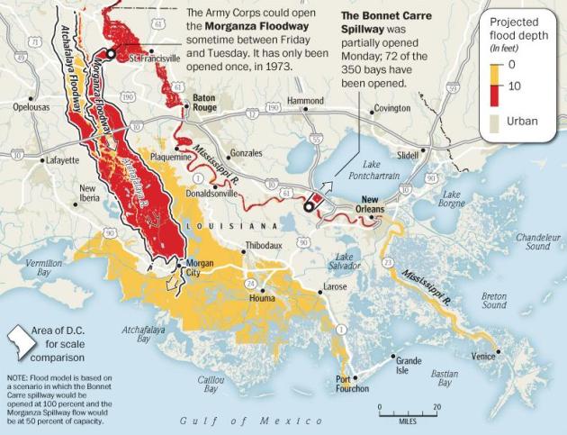
In Louisiana, A Choice Between Two Floods. I would not want to be the top guy at the Army Corp of Engineers, having to make some impossible choices right now. Protect cities or farmland? The Washington Post has the
story: "
Flood the farms to save the cities. That’s the trade-off staring at the Army Corps of Engineers in Louisiana this week as a historically high Mississippi River rolls south, flooding towns in Mississippi on Wednesday, prompting evacuations farther south, and threatening the heavily industrialized petrochemical corridor running from Baton Rouge to New Orleans and beyond. About a million people live along that corridor, in addition to the New Orleans residents who endured a flooding nightmare six years ago when levees failed after Hurricane Katrina. So the corps is confronted with a Devil’s choice: cause a flood that would drown the livelihoods of central Louisiana farmers and fishermen, or let the high river roll and frantically sandbag 200 miles of levees to try to prevent flooding in the state’s two biggest cities. If the swollen Mississippi is allowed to run full bore through the state, the water would eat away at levees and could overtop sections, drowning some districts of New Orleans under about 25 feet of dirty water — an inundation even greater than the Katrina disaster, according to a worst-case map prepared by Walter Baumy, chief of engineering for the corps’ New Orleans office."
Opening A Spillway: "As floodwaters descend toward the Mississippi River delta, Corps engineers are considering opening a spillway that would divert water away from the downstream urban cities of Baton Rouge and New Orleans and relieve pressure on levees along the Mississippi." (graphic courtesy of the
Washington Post).
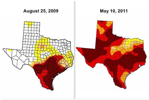
One "Exceptional" Drought. The Weather Channel has an
interesting post about the severity of the drought gripping Texas and much of the Deep South. Historic flooding on the Mississippi moving into an area of "exceptional drought". Remarkable:
% of state in exceptional drought:
-
Texas: 47.5%
-
Oklahoma: 15.1%
-
Louisiana: 11.2%
-
Kansas: 0.2%
"
Incredibly, while the Lower Mississippi Valley flirts with record flooding, less than 200 miles away, exceptional drought grips western Louisiana. The Slidell, La. National Weather Service Office put out a drought statement Thursday saying the flooding is "providing immediate drought relief", although I think we can all agree this is not the way to bust a drought. Oh yes, one other notable: just under half the state of Texas is in this "worst drought" category! Records on aerial coverage of the Drought Monitor have only been kept since Jan. 2000. In that time, according to TWC Senior Meteorologist Stu Ostro (Find him on Facebook ), the previous maximum coverage of exceptional drought in Texas was a mere 18.8% on Aug. 25, 2009. The comparison below of that '09 drought to the present drought speaks for itself. (Again, darkest brown shading shows the worst, or "exceptional" drought.)
"
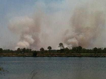
After A Day's Break, Smoky Conditions Back. Snow in Colorado, an epic (historic) flood on the Mississippi, much of the Deep South still cleaning up from April's record swarm of killer tornadoes, Texas in the midst of an "exceptional drought". Add smoke to the list. Here's an
update from CBS2 in Miami: "
COLLIER COUNTY (CBS4) – After a day’s respite, South Florida once again woke up to smoky, hazy conditions thanks to a wildfire burning in the Big Cypress National Preserve in Collier County. Wednesday night park spokesman Jim Payne said the fire, which had burned more than 38 thousand acres, was about 85 percent contained and they are starting to release fire crew members as needed. On Thursday, fire crews plan to improve indirect control lines on the northwest flank and burn out interior areas of unburned fuel. They will also patrol and mop up the remainder of the fire perimeter as needed. The fire was sparked on April 26th by a lightning strike. As of Wednesday, the fire was 70 percent contained. The park service does not expect to have the fire fully contained until May 18th."
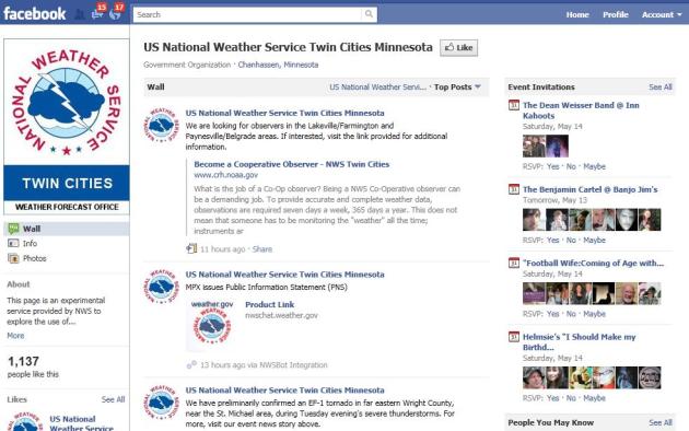
The Local (Chanhassen) Office Of The National Weather Service Is On Facebook. Click
here to find out more.
7 Tech Trade-Offs Worth Making. Sam Grobart from the New York Times has some
helpful tips about avoiding some of the worst mistakes you can make on the tech treadmill: "
Buying gadgets can sometimes be like buying a car; it requires sorting through options. Do you go for the navigation package or the rear-seat entertainment system? The faster processor or more memory? The easy answer is “both.” But the reality is that most of us are usually dealing with a finite amount of money to spend, and that means making trade-offs. We want to get the most bang for our buck, not to be lured into paying for features and options that are not worth the money. Below is some guidance about what is worth paying for, and what can be left unchecked on the options list.
PAY FOR PC MEMORY, NOT SPEED When buying and configuring a new computer, companies often give the option of upgrading the processor and adding more memory, or RAM. If it is an either/or proposition, go for the RAM. Processors are usually fast enough for most people; it is the RAM that can be the bottleneck. Here’s a side note on RAM: Do not buy it from your manufacturer; RAM purchased from online retailers is just as good and considerably cheaper. Check out retailers like Crucial (for Windows machines) and Smalldog (for Macs). Each will tell you what kind of RAM you need for your machine, and they often sell it for more than half off the manufacturer’s retail price."
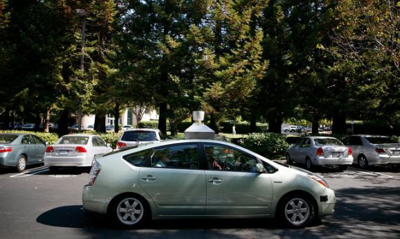
Google Lobbies Nevada To Allow Self-Driving Cars. Note to self: avoid Las Vegas and Reno until further notice. Not sure I want to be part of a beta experiment focused on driver-less automobiles. Here are the
details from the New York Times: "
Google, a pioneer of self-driving cars, is quietly lobbying for legislation that would make Nevada the first state where they could be legally operated on public roads. And yes, the proposed legislation would include an exemption from the ban on distracted driving to allow occupants to send text messages while sitting behind the wheel. The two bills, which have received little attention outside Nevada’s Capitol, are being introduced less than a year after the giant search engine company acknowledged that it was developing cars that could be safely driven without human intervention. Last year, in response to a reporter’s query about its then-secret research and development program, Google said it had test-driven robotic hybrid vehicles more than 140,000 miles on California roads — including Highway 1 between Los Angeles and San Francisco."
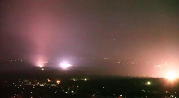
What The... Check out this
YouTube clip from the Dallas/Ft. Worth metroplex. Alien invasion, or another, more logical explanation. Here's one theory: "
FORT WORTH - Several electrical transformers exploded and sparked east of downtown Fort Worth Tuesday night, making the city look like it was under attack. Although electrical service provider Oncor has not provided an update on exactly what happened, it is presumed that lightning from one of the storms that rolled through Tuesday evening struck one of the transformers and sparked a chain reaction of explosions."
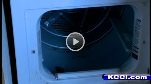
Boy Rides Out Tornado In Dryer. Hey, if a bathtub is relatively safe, maybe a dryer is even safer? Not sure I can officially recommend this tactic, but it seems to have worked for a young boy caught in a tornado in Lennox, Iowa, according to
this story from KCCI-TV: "
A boy rides out a tornado in the laundry room dryer. Amanda Lewis reports."
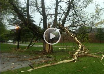
Lightning Strike Pulls Wedding Ring Off Finger. Now I've seen everything. "Yes honey, the reason I'm not wearing my wedding band is because lightning blasted it off my finger!" KCCI-TV in Des Moines has the
story:
"OMAHA, Neb. -- A lightning bolt shatters a tree at an Omaha school Wednesday moments after staff members moved students away from it.The tree was a century old staple outside Skinner Magnet School near 33rd and Taylor before Wednesday’s storm. The lightning bolt that hit it was so strong it shocked the principal’s wedding ring right off his finger.On a normal day, students would have walked right under that tree at the time it came down. Wednesday, as the storm passed through, staff moved the school buses around the corner so students would have a shorter walk in the rain.Teacher Dustin Driever was standing outside holding an umbrella when lightning hit the tree.“I saw a little bit of smoke,” said Driever. “The initial thought was what just happened?”Driever’s umbrella carried the current from the lightning bolt right through his hand.“It felt like 1000 little pins inside it,” said Driever. Driever went to the hospital as a precaution. Both he and the principal will be fine, and both said they paid a small price for their students’ safety."
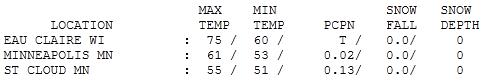
Sloppy Thursday. Showers fell much of the day, heaviest rain on the north side - Crystal picked up a third of an inch of rain. Nearly 1" soaked Redwood Falls. Temperatures held in the 50s most of the day, a good 10-15 degrees cooler than average for May 12.
Paul's SC Times Outlook for St. Cloud and all of central Minnesota:
TODAY: More clouds than sun, stray shower possible. Winds: N 10-20. High: 54
FRIDAY NIGHT: Still cool and damp, few showers. Low: 42
SATURDAY (FISHING OPENER): Soggy Opener. Few showers likely. Winds NE 10-20. High: 52
SUNDAY: Getting better, sun returns - nicer day of the weekend. Winds: NE 10-20. Low: 41. High: 60
MONDAY: Blue sky; take a vacation day. Low; 41. High: 64
TUESDAY: Lot's of sun, perfect spring day. Low: 46. High: 65
WEDNESDAY: Best week of spring? More sunshine. Low: 45. High: 67
THURSDAY: Still nice. No blobs on Doppler. Low: 47. High: 68
Fishy Factoids
You can prove anything with statistics. For example, 3 out of 4 Fishing Openers in Minnesota are "dry". 4 of the last 56 Openers have seen a "trace" of snow on northern lakes; on 3 occasions lakes were still FROZEN! Good grief. So much for the law of averages. A stubborn storm in the upper atmosphere will keep showery rains overhead much of Saturday, highs stuck in the low 50s, a raw north wind at 10-20. Other than that it should be quite lovely. Skies clear Saturday night, a Canadian high should turn the sun back on Sunday with 60s, chirping robins and smiles. One silver lining: the sky draped overhead will be too cool, dry & stable for anything severe through next week.
Here are some eye-opening statistics: 875 tornadoes in April, a new U.S. record. Wettest April since 1895 from Illinois to Pennsylvania. 95% of Texas is experiencing severe or exceptional drought. Storms triggered $2.6 billion in damage this past winter; one of the 5 most damaging winters on record.
How many times can I use "record" in one weather column? Is it just YouTube, Twitter and more camera-toting storm chasers, or is this the "new normal"; more super-sized storms on fast-forward? Place your bets.
High Waters: A Climate Connection To The Mississippi River Floods? Andrew Freedman has a
timely post at onearth.com: "
Climate change cannot be blamed for causing the flooding, but scientists have detected large-scale trends indicating that extreme precipitation events are becoming more likely as temperatures warm in response to increasing amounts of greenhouse gases in the air. This means that heavy rainfall events are more frequent than they used to be, in part because a warmer atmosphere holds more moisture that can be wrung out by storm systems. Scientists are working to detect the "fingerprint" of climate change in specific extreme weather events, and their methods are still in their infancy. It will take many months for studies to be completed on whether climate change may have made April’s heavy rains more likely. For now, though, we can look at studies that have already been completed that offer some clues about the relationship between climate change and heavy precipitation events. Two studies published this year in the journal Nature have tied climate change to precipitation trends. One study found that in most of the U.S., two measures of extreme rainfall -- the highest one-day rainfall amount per year and the highest five-day amount per year -- are increasing. In other words, the study concluded that extreme rainfall events are becoming more common in the US, and indeed throughout much of the Northern Hemisphere. Importantly, the paper attributed these larger scale trends in part to climate change from increasing amounts of greenhouse gases in the atmosphere. The other study analyzed one particular flood event that occurred in the U.K. in the fall of 2000. In this case, scientists simulated the atmospheric conditions when that flood took place, looking to see how various levels of greenhouse gases (2000 levels vs. preindustrial times) influenced the odds that the floods would happen. In order to accurately simulate the floods, they paired an atmospheric computer model with a hydrographic model that simulates river conditions."
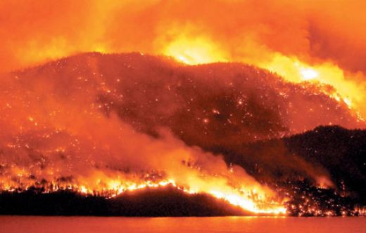
Mega-Fires May Be Contributing To Climate Change, UN Report Finds. It's another example of "positive feedback". Climate change increases the frequency and severity of drought, which increases the potential for wildfires, which release additional carbon that further warms the air, making drought worse, etc etc. Here's an
article from Fire Engineering: "
The growing number of mega-fires around the world may be contributing to global warming, a new United Nations report says, calling on governments to introduce comprehensive strategies to reduce the risk of such conflagrations. The report from the Food and Agriculture Organization (FAO), released on 10 May at an international conference in South Africa, says policy-makers need to improve their monitoring of carbon gas emissions from wildfires to better determine the potential climate change impacts. The report's release follows a series of high-profile mega-fires, including the February 2009 Black Saturday blazes in Australia that killed 173 people and obliterated many towns, and record-setting fires last year in Russia that claimed the lives of 62 people and burned about 2.3 million hectares. The report examined recent mega-fires in Australia, Botswana, Brazil, Indonesia, Israel, Greece, Russia and the United States. Pieter van Lierop, a forestry officer with FAO, said today that the problem was becoming more urgent as the frequency and size of mega-fires increase and weather projections indicate hotter and drier fire seasons. "Mega-fires are mainly caused by humans and are likely exacerbated by climate change, but now we suspect they may also in themselves represent a vicious circle that is speeding up global warming." The report found that nearly all the mega-fires studied were started by people, sometimes deliberately to clear land for the purposes of agriculture or development."
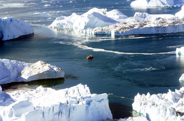
Arctic Council To Address Role of Soot In Global Warming. The darkening of Arctic ice is a growing concern, highlighted in this Washington Post
story: "
KANGERLUSSUAQ, GREENLAND — Secretary of State Hillary Rodham Clinton touched down Wednesday on Greenland’s rocky, snow-flecked coast for two days of talks on the Arctic, as the Obama administration seeks to draw attention to the rapidly accelerating loss of sea ice and surging interest in the region’s natural resources. Rapid warming above the Arctic Circle has led to shorter winters and a dramatic thinning of Arctic ice in the past two decades, and new scientific data suggest that the rate of polar melting has accelerated far beyond what scientists had forecast a few years ago. One study, the conclusions of which were released last week, predicts that the resulting rise in global sea levels could reach as much as five feet by the end of the century. Greenland is also confronting developmental pressures by companies racing to claim natural resources exposed by retreating ice. “Greenland is coming your way, and faster than you think,” said Brooks Yeager, a former State Department official and vice president of the Washington-based environmental group Clean Air-Cool Planet."
School Board Orders Global Warming Class To Include "Conservative Views". This is a worrying trend: forget about the science, let's present "both sides" of this controversial argument. It's not an argument - it's science. The spin and denial continues, according to an
article at losalamitos.patch.com: "
Before Los Alamitos High School science teachers can tackle topics such as global warming, they will have to demonstrate to the school board that the course is politically balanced. A new environmental science course prompted the Los Alamitos Unified School District on Tuesday to rewrite its policy for teaching controversial subject matter. Concerned that "liberal" faculty members could skew lessons on global warming, the board of education unanimously voted to make teachers give an annual presentation on how they're teaching the class. I believe my role in the board is to represent the conservative voice of the community and I’m not a big fan of global warming,” said board member Jeffrey Barke, who led the effort. “The teachers wanted [the class], and we want a review of how they are teaching it.”
Coal Curriculum Called Unfit For 4th Graders. Should the coal lobby be reaching out to 4th graders in our schools? The New York Times
reports: "
Three advocacy groups have started a letter-writing campaign asking Scholastic Inc. to stop distributing the fourth-grade curriculum materials that the American Coal Foundation paid the company to develop. The three groups — Rethinking Schools, the Campaign for a Commercial-Free Childhood and Friends of the Earth — say that Scholastic’s “United States of Energy” package gives children a one-sided view of coal, failing to mention its negative effects on the environment and human health. Kyle Good, Scholastic’s vice president for corporate communications, was traveling for much of Wednesday and said she could not comment until she had all the "United States of Energy” materials in hand. Others at the company said Ms. Good was the only one who could discuss the matter. The company would not comment on how much it was paid for its partnership with the coal foundation. Scholastic’s InSchool Marketing division, which produced the coal curriculum in partnership with the coal foundation, often works with groups like the American Society of Hematology, the Federal Trade Commission and the Census Bureau to create curriculum materials."
Aquarius To Illuminate Links Between Salt, Climate. NASA has the
story: "
When NASA's salt-seeking Aquarius instrument ascends to the heavens this June, the moon above its launch site at California's Vandenberg Air Force Base won't be in the seventh house, and Jupiter's latest alignment with Mars will be weeks in the past, in contrast to the lyrics of the song from the popular Broadway musical "Hair." Yet for the science team eagerly awaiting Aquarius' ocean surface salinity data, the dawning of NASA's "Age of Aquarius" promises revelations on how salinity is linked to Earth's water cycle, ocean circulation and climate. Salinity – the concentration of salt – on the ocean surface is a key missing puzzle piece in satellite studies of Earth that will improve our understanding of how the ocean and atmosphere are coupled and work in tandem to affect our climate. While satellites already measure sea surface temperature and winds, rainfall, water vapor, sea level, and ocean color, measurements of ocean surface salinity have, until quite recently, been limited to sparse data collected from ships, buoys and a small number of airborne science campaigns. From those limited data, we know ocean surface salinity varies by only about five parts per thousand globally. Yet a change of just a fraction of one part per thousand can influence the circulation of the ocean. Knowing the salinity of the ocean surface can also help scientists trace Earth's water cycle – the process that circulates freshwater from the ocean to the atmosphere to the land and back again to the ocean through rainfall, evaporation, ice melt and river runoff. Aquarius, the primary science instrument on the Aquarius/Satélite de Aplicaciones Científicas (SAC)-D spacecraft built by Argentina's national space agency, Comision Nacional de Actividades Espaciales, will help scientists study these complex, interrelated processes and their link to climate.
Recent studies have shown Earth's water cycle is speeding up in response to climate change, which affects global precipitation patterns. Currently, scientists study the water cycle by making inferences from measurements of how much water is discharged from rivers and by measuring precipitation and evaporation rates using satellites like NASA's Tropical Rainfall Measuring Mission."


No comments:
Post a Comment