* 80 F. high predicted for St. Cloud this afternoon, warmest reading since October 8, 2010 (84 F.)
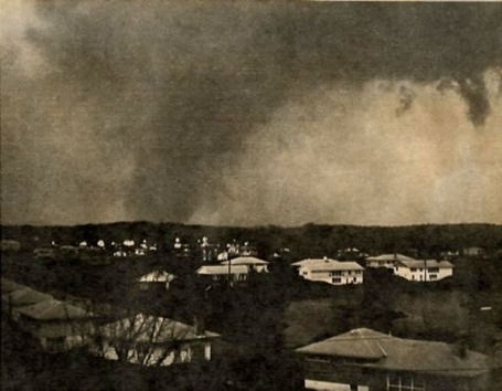
"The awful, unexpected storms beggared description. “It sounded like 49 trains running wide open,” said one survivor." From "The Master Forecaster", focusing on the recent Alabama tornado outbreak, highlighted below.
* Contrary to myth, rumor and innuendo, there is no local "Tornado Alley" in the Twin Cities metro.
* 4,785 years. According to SPC the average neighborhood in central Minnesota can be expected to be hit by a tornado once every 4,785 years. Give or take.
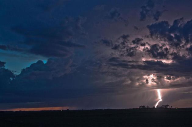
Don't Try This At Home. Doug Kiesling is a prolific storm chaser. Early Monday he was up at Big Lake, where he captured this amazing image of lightning. Check out his work at stormpaparazzi.com.
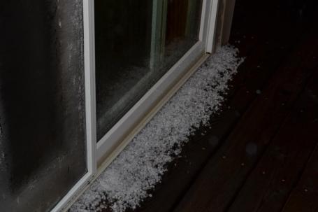
"Hailers." Sheena Nelson, dedicated wife of WeatherNation meteorologist Todd Nelson, was up at 4 am Monday morning to photograph the pea to marble size hail that fell in the St. Michael area. Penny-size hail was reported at Hanover. Good work Sheena! The local NWS office has more damage reports here.
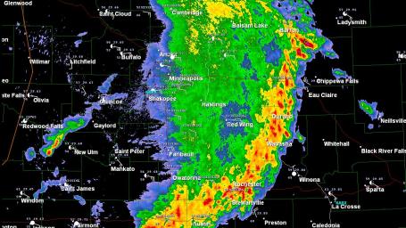
"MCS". Monday morning's storms were part of a Meso-convective system, a swarm of strong/severe thunderstorms covering thousands of square miles. These 200-500 mile wide bands of storms usually form over the Plains during the late night hours, fueled by moisture from the Gulf of Mexico and strong, low-level jet stream winds that focus upward motion along warm frontal boundaries. MCS systems rarely produce tornadoes, but they can spark torrential rains, frequent lightning strikes, small hail and straight-line wind damage. Prime time is May through July.
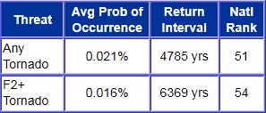
Perspective. According to the SPC, the Storm Prediction Center, the average annual probability for any location in the Twin Cities metro to experience a tornado is .021% They calculate that you'll see a tornado outside your window once every 4,785 years - but if the larger, EF-2+ strength tornadoes come around, on average, once every 6,369 years. As I mention in the column, I wouldn't lose too much sleep over this - but it's always good to have a plan, to make sure your kids (and significant other) knows exactly what to do if threatening weather is approaching your house. With enough warning (and adequate shelter below ground, if possible) almost any tornado is survivable. But you may be (a little) relieved to hear that you stand a far greater chance of winning the Lotto than seeing a tornado swirling above your roof.
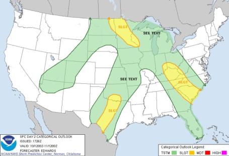
Tuesday Severe Risk. According to SPC there is a "slight risk" of isolated severe storms from eastern North Dakota into much of northern, central and southeastern Minnesota into west central Wisconsin later today. The Twin Cities is in the slight risk area - we need to be prepared for the potential for large hail, potentially damaging straight-line winds, even a few isolated tornadoes. I do expect some watches/warnings to be issued by afternoon.
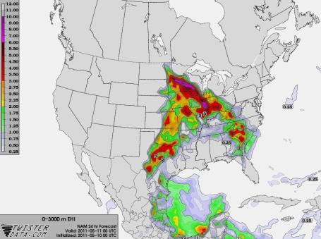
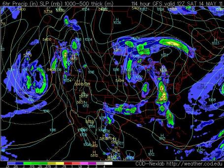
Converging Ingredients. This is the predicted EHI, Energy Helicity Index (a measure of both instability and wind shear), valid Tuesday evening at 7 pm, showing a potential severe storm bullseye from central Minnesota into southwestern Wisconsin. The only thing that may prevent severe storms (at least in the metro area): a surge of warm, dry air aloft may "cap" the atmosphere, inhibiting thunderstorm development. Right now it's still too close to call: the dynamics will be very strong, potentially strong enough to overcome the cap and spark a few "supercell" thunderstorms. Twisterdata.com has more raw data and maps here.
Wednesday Threat. Moist, 80-degree air lurking just to the south of the Twin Cities coupled with dew points in the low 60s (and sufficent wind shear and instability aloft) may create a ripe environment for a few severe thunderstorms Wednesday as well, especially over the southeastern half of Minnesota and Wisconsin. By Thursday the threat shifts south/east of MInnesota.
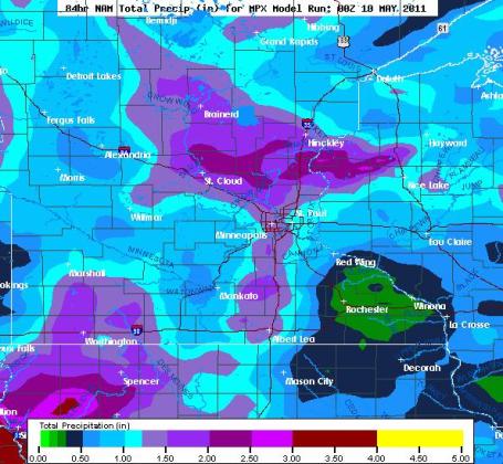
Potential For Significant Rain. The latest NAM model suggests some 1"+ rainfall amounts close to home over the next 84 hours, less rain over southeastern Minnesota - heaviest amounts over the north metro, St. Cloud, Brainerd and Hinckley.
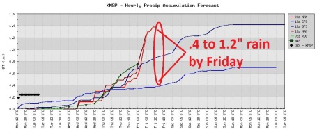
A Soggy Week. Rain will be convective (showery) into Wednesday, a wave of low pressure rippling north along a stalled front may trigger heavier, steadier rain Thursday. Some towns could easily wind up with more than 1" of rain by Friday.
Foul Fishing Opener? The models are all fairly consistent in keeping an area of low pressure stalled over Wisconsin, "wrap-around" showers spilling over into Saturday, possibly Sunday as well. A few hours of rain may fall on Saturday, temperatures in the 50s, maybe some low 60s over southern lakes - but a cool, damp, breezy Fishing Opener seems to be on the way.
Walleye Fishing Opener Outlook for Saturday:
Mostly cloudy
3-6 hours of showers
Winds: N/NE 10-20
1-2 foot waves on area lakes
AM temperatures: 41-46. PM temperatures: 55-60

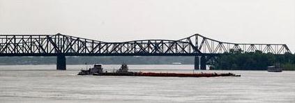
Mississippi River At Memphis Could Crest Monday. An update from the AP: "MEMPHIS, Tenn. (AP) -- Forecasters say the Mississippi River could crest late Monday at Memphis - hours sooner than previously predicted - but the mayor says the city's ready for it. Mayor AC Wharton said that despite the tightened timeframe, he's confident that precautions such as door-to-door warnings have prepared the city. "We don't have as much time, but fortunately we're ready for it," Wharton told The Early Show on CBS Monday. To the South, authorities in Louisiana stepped up their preparations by opening floodgates at a spillway northwest of New Orleans to take pressure off levees in populated areas. Inmates were also scheduled to be moved from a prison near Baton Rouge. The Memphis mayor said disasters such as Katrina have shown that you can't simply get the word out by issuing warnings on TV. Authorities spent the weekend knocking on doors to tell a couple hundred people that they should abandon their homes before they are swamped by waters from the rising Mississippi. Wharton said officials are returning to some houses multiple times."
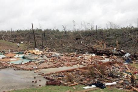
132 Miles Of Devastation: EF-5 Tornado Deadliest In The United States In The Last 56 Years. Al.com has the story: "What the National Weather Service calls the Hackleburg Tornado traveled 132 miles, winds surpassing 210 mph, a nonstop scar in the earth running 90 miles from Hackleburg to Huntsville. Of a dozen deadly twisters across Alabama on April 27, this was the only one given the strongest rating of EF-5. This one tornado alone is thought to have claimed 70 lives, by far the deadliest single twister in state history. The Times this week traced the path of destruction, where countless survivors spoke with calm and wonder at simply being alive."
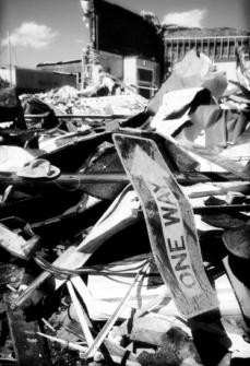
The Master Forecaster. Birmingham Weekly has a terrific, very well-written story about tornado prediction, specifically focused on TV meteorologist James Spann, who's cool, calm delivery on April 27-28 kept Alabamans informed, and probably saved countless lives: "On that early spring afternoon, the air was unsettled and the temperature was in the 80s. The clouds welled up, as they always seem to, out of deep-west central Alabama, rising, cohering and finally spinning back into the earth, heading north and east. They turned into tornadoes of varying sizes, cutting horrible swaths through the green countryside, killing a lot of people and displacing many more. The awful, unexpected storms beggared description. “It sounded like 49 trains running wide open,” said one survivor. In Tuscaloosa, University of Alabama students joined in to assist the injured. In Cullman County, a twister left a 20 mile trail of destruction. Whole communities were smashed to splinters, and the governor traveled for days after the event, trying to reach all the damaged areas throughout the state. After some time, it was determined that 298 citizens had died of the weather and almost 2000 more were injured. It would go down in history as Alabama’s worst natural disaster of the century. In that century, the year was 1932. When a dangerously similar scenario developed 79 years later, practically everything had changed in Alabama except its predisposition to generate killer storms. In this century, despite having a large, mobile population and a sophisticated forecast system, nearly 300 lives had again been lost to the implacable fury of tornadoes. As you read elsewhere in these pages, you will see that each witness to last week’s catastrophe experienced it inimitably. Many of us spared by the storm experienced it vicariously, through a marathon performance by a local TV weatherman at the top of his game. You cannot live in this state and not respect the tornado, but it is understandable that we get jaded by its ubiquity. Too, the era of the Weather Channel stormchaser has made us falsely conversant with the lore and lingo of killer storms; it’s not just a tornado, it’s a Cantore Story. We are often lulled into thinking a tornado watch is just another event to plan around. The miserable truth is that we dwell among tornadoes as pan fish among sharks, never truly knowing when the brute killing machines will turn on us. Expert witnesses cite the homicidal caprice of tornado winds with equal parts of awe and disgust. A hurricane has a track unimpeded by topography, and you’ll see it coming a week away. A tornado has a hook echo. You’re really just seeing where it’s already been...."
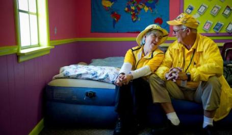
For Some, Helping With Disaster Relief Is Not Just Aid, It's A Calling. Thank God we have big-hearted people like this in this country. The New York Times has the story: "RAINSVILLE, Ala. — Some couples spend retirement playing the nation’s best golf courses or hopping cruise ships. Not Marteen and Wiley Blankenship. They collect disasters the way other retirees collect passport stamps. The minute they got the call from Southern Baptist Convention disaster relief leaders that tornadoes had ripped through the South, the Blankenships grabbed their sleeping bags and sturdy shoes and headed out from their home in Decatur, Ala. Together, they have cleaned up after Hurricane Katrina, mucked out flooded homes in Atlanta and built houses in Sri Lanka. And for the past week they were camped out here in a rural part of northeastern Alabama where 48 lives were lost and thousands more disrupted in the storms. Mr. Blankenship, 70, and Mrs. Blankenship, 69, heated up chili and Salisbury steak, handing it out to people who drove through a church parking lot and packing it into Red Cross vans that carry meals into the remote countryside. And they did it all for God. “I thought when we were done working that I wanted to travel,” said Mrs. Blankenship, a former flight attendant. “I just never thought it’d look like this. But it’s our calling.”

Pets Displaced By Tornadoes Await Reunions. The story from Yahoo News: "TUSCALOOSA, Ala. – Those leaving the Tuscaloosa Metro Animal Shelter these days are either overjoyed after finding their pets lost when tornadoes ravaged the region or heartbroken and often moved to tears when they don't. Reginald Jackson has felt both. He walked up and down the rows of cages, looking for his pit bull Bolo, but the dog was nowhere to be found. About to leave, distressed that his year-old animal was still missing, Jackson looked and there was Bolo. A veterinarian was walking him from an exam. "Someone was coming in the door with him," said the 55-year-old Jackson, a stockroom worker. "I was glad to see him." Hundreds of animals have ended up at this single shelter after the storms. Some are injured, others simply scarred by fear. "These dogs are so stressed out, they are scared and they just don't want to come up to the front of the cage," said Linda Workman, the shelter's assistant director. "They're just as traumatized as the humans." The trauma is evident in the dogs who have crouched in the backs of their cages, fearful of passersby."
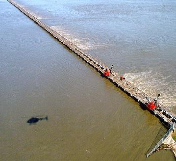
Mississippi River Sets All-Time Flood Records; Second Major Spillway Opens. Dr. Jeff Masters has an update on the historic flooding underway in his Wunderblog: "The Mighty Mississippi continues to wreak havoc as the river's highest flood crest in history pushes southwards near Memphis, Tennessee today. The river crested at its highest height on record over the past four days along a 70-mile stretch from New Madrid, Missouri to Tiptonville, Tennessee, to Caruthersville, Missouri, smashing records that had stood since the great flood of 1937. The flood height of 47.6' at Caruthersville, Missouri, on Saturday was a full 1.6 feet above the previous record flood height, set in 1937. However, thanks in part to decision by the Army Corps of Engineers last Monday to intentionally destroy a levee at Birds Point on the west bank of the Mississippi, pressure on the levees along this stretch of river was substantially reduced, potentially preventing multi-billion-dollar levee breaches. Currently, the Mississippi is expected to reach its 2nd highest level on record at Memphis on May 10, cresting at 48.0'. The all-time record at Memphis occurred during the great flood of 1937, when the river hit 48.7'. Downstream from Memphis, flood waters pouring in from the Arkansas River, Yazoo River, and other tributaries are expected to swell the Mississippi high enough to beat the all-time record at Vicksburg, Mississippi by 1.3' on May 19, and smash the all-time record at Natchez, Mississippi by six feet on May 21, and by 3.2 feet at Red River Landing on May 22."
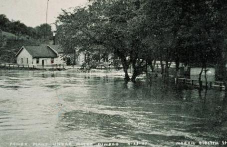
As Mississippi Rises, Historian Discusses Great Flood of 1927. Some additional insight and perspective from PBS: "As the Mississippi River continues to rise Monday, threatening Memphis and other cities on its shores, we take a look back at another deluge: The Mississippi River flood of 1927, which is still the landmark event against which many U.S. floods are measured, and one that forever changed how levees and flood control systems are built across the country. According to John M. Barry, a New Orleans resident and the author of the New York Times bestseller "The Great Flood of 1927 and How it Changed American History," between six and 11 inches of rain fell along the entire Mississippi River in 1927. Some places received 14 inches of rain in 18 hours, and the river was running at three million cubic feet per second. Currently, the flow rate prediction just downriver from Cairo, Illinois is for 1.89 million cubic feet per second -- about half that of the 1927 flood. "The most subtle but most important impact of (the 1927) flood is that it changed the way Americans viewed the federal government and redefined the way people viewed government and individual responsibility," Barry said during a lecture at FEMA's recent National Flood Conference in New Orleans."

Memphis Flood Update. Thanks to Chad Merrill at Earth Networks (formerly Weather Bug) for passing along this link with additional flood crest information. If the Mississippi does, in fact, crest at 48 feet, it will be the second highest crest on record in Memphis, second only to the 48.7 foot crest on February 10, 1937. Here's a quick update:
THE FLOOD WARNING CONTINUES FOR
THE MISSISSIPPI RIVER AT MEMPHIS
* UNTIL FURTHER NOTICE.
* AT 11 AM MONDAY THE STAGE WAS 47.8 FEET.
* MAJOR FLOODING IS OCCURRING AND MAJOR FLOODING IS FORECAST.
* MAXIMUM FORECAST STAGE OF 48.0 FEET TUESDAY MAY 10.
* FLOOD STAGE IS 34.0 FEET.
* THE RIVER ROSE ABOVE FLOOD STAGE AND WILL CONTINUE RISING TO NEAR
48.0 FEET BY TUESDAY MAY 10 THEN BEGIN FALLING.
Historical Crests for Mississippi River at Memphis
(1) 48.70 ft on 02/10/1937
(2) 45.80 ft on 04/23/1927
(3) 40.76 ft on 03/14/1997
(4) 40.50 ft on 05/08/1973
(5) 40.50 ft on 02/22/1950
(6) 40.30 ft on 03/07/1975
(7) 40.20 ft on 05/22/1961
(8) 39.20 ft on 04/06/1945
(9) 39.20 ft on 05/15/1983
(1) 48.70 ft on 02/10/1937
(2) 45.80 ft on 04/23/1927
(3) 40.76 ft on 03/14/1997
(4) 40.50 ft on 05/08/1973
(5) 40.50 ft on 02/22/1950
(6) 40.30 ft on 03/07/1975
(7) 40.20 ft on 05/22/1961
(8) 39.20 ft on 04/06/1945
(9) 39.20 ft on 05/15/1983
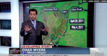
Did Melting Snow Contribute To Historic Flooding? As usual, finding a simple cause and effect with the Great 2011 Flood on the Mississippi is difficult. A stalled front dropped 10-20" of rain on waterlogged soil, but rapidly melting snow over northern tier states also contributed to the scope of this slow-motion disaster, as explained by CNN meteorologist Chad Myers: "CNN's Chad Myers explains how heavy snow ultimately caused the flooding disaster along the Mississippi River."
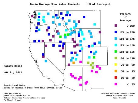
Record Snows Out West. Snowpack across much of the west is running 150 to 250% of normal, meaning 1.5 to 2.5 times more snow on the ground than usual as of May 9, according to NRCS SNOTEL.
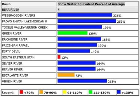
Record Snow Brings Flood Threat To Utah And The West/Lake Mead Area. Accu Weather's Ken Clark has more details: "The Sierra has not been the only place record winter snowfall occurred this year. Utah north to Wyoming and Montana also had abundant snow. Here is an example of the abundant snow that still exists in much of northern to southwest Utah mountains. This graph shows the snow water equivalent as a percentage of normal as of today from the National Resources Conservation Service. All this snow is going to melt of course and this is where we have the good news and bad news scenarios. The bad news is that the threat for flooding, and in some areas major flooding, is high and how bad it gets will be determined by how quickly the snow is going to melt. It is not a question of whether there will be flooding, there will be flooding, but how bad is it going to get. The current snowpack is well above what it was in 1983 when massive floods occurred in northern Utah causing 250 million dollars of damage as crops were wiped out along with homes and businesses. Flooding is a given and a quick warm-up could cause catastrophic flooding. This is what is worrying many officials. And what is happening today and tonight will not help matters. Rain is likely in lower elevations and heavy snow is likely in the mountains with a foot or more of snow above 7,000 feet."

Record Heat. The weather pattern is a study in extemes. Historic flooding on the Mississippi moving into a region of epic drought (Louisiana). The most severe tornado outbreak on record for the USA April 27-28. Record snow pack in the west, and now an early taste of triple-digit heat, according to NOAA:
RECORD EVENT REPORT
NATIONAL WEATHER SERVICE SIOUX FALLS SD
311 PM CDT MON MAY 9 2011
...RECORD HIGH TEMPERATURE BROKEN AT SIOUX CITY IOWA...
AT 307 PM CDT THE TEMPERATURE AT SIOUX GATEWAY AIRPORT IN SIOUX CITY
IOWA HIT 93 DEGREES. THIS BREAKS THE RECORD HIGH FOR THE DATE SET IN
2001 AND 1928._________________________________________________________
RECORD EVENT REPORT
NATIONAL WEATHER SERVICE WICHITA KS
210 PM CDT MON MAY 9 2011
...TEMPERATURE HIT 100 DEGREES AT WICHITA MID-CONTINENT AIRPORT...
AT 2:00 PM CDT THE TEMPERATURE AT WICHITA MID-CONTINENT AIRPORT
REACHED 100 DEGREES. NOT ONLY HAVE WE BROKEN THE RECORD WHICH WAS 95
SET IN 1895...THIS IS THE EARLIEST IN THE YEAR WE HAVE EVER REACHED
100 DEGREES. PRIOR TO TODAY THE EARLIEST IN THE YEAR WE HAD EVER GOT
TO 100 DEGREES WAS MAY 10, 1967 WHEN THE TEMPERATURE REACHED 100.

Trees Provide Natural Record Of El Nino Trends. Hawaii's staradvertiser.com has an interesting story about using tree rings to track El Nino and La Nina temperature fluctuations in the Pacific: "Studying treering records from the southwestern United States, University of Hawaii scientists have helped assemble a 1,100-year historical picture of the climate phenomenon known as El Niño, offering an avenue to understanding how weather patterns could change in a warming world. El Niño, associated with warmer than usual sea surface temperatures in the eastern tropical Pacific, typically produces a wide array of violent weather, including more rain and intense storms in some areas, less rain in others. The massive El Niño of 1997-98, for instance, caused flooding and landslides in Northern California, drought and famine in Bangladesh and drought and forest fires in the Philippines; 2,100 people died worldwide. UH scientist Jinbao Li said by email that the record implies that warmer oceans will lead to more severe El Niños and the opposite phenomena, La Niñas, and more extreme climate conditions around the globe. But a final verdict awaits better climate models, he said. Formally known as the El Niño Southern Oscillation, the phenomenon also brings rainy winters to the U.S. Southwest, where tree rings are wide in wet years and narrow in dry years."
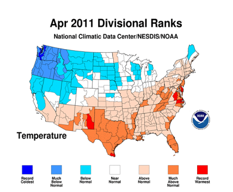
April Recap. Here are more details about April than you probably wanted to know - courtesy of our pals at NOAA: "April U.S. temperature ranked 39th warmest, precipitation ranked 10th wettest. Historic flooding, a record-breaking tornado outbreak and devastating wildfire activity made April 2011 a month of historic climate extremes across much of the United States, according to scientists at NOAA’s National Climatic Data Center (NCDC) in Asheville, N.C. The average U.S. temperature in April was 52.9 degrees F, which is 0.9 degrees F above the long-term (1901-2000) average. April precipitation was 0.7 inches above the long-term average, the 10th wettest April on record. This monthly analysis, based on records dating back to 1895, is part of the suite of climate services NOAA provides. Fueled by record-setting precipitation totals, historic and near-historic flooding occurred throughout the Midwest and Ohio Valley, from the smallest streams to the largest rivers. The Ohio Valley region had its wettest April on record and it was the second wettest for the Northeast. Illinois, Indiana, Kentucky, Ohio, West Virginia and Pennsylvania each had their wettest April since 1895. An average of 11.88 inches of precipitation fell across Kentucky, nearly three times its long-term average, breaking the previous record (7.61 inches in 1972) by more than four inches."

10 Important Calls To Make After Flood Damage. Here's a helpful post that provides a checklist of things to consider after flooding, either flash flooding or river flooding: "Flood waters can cause a lot of destruction to your home, depending on how high the waters were, and how long it takes them to recede. The water can damage not only the contents of your home, but much of the building materials using in your home as well. If this is the first time you have experienced flood damage to your home, it can be overwhelming. Here is a list of ten important phone calls to make once the flooding is over.
- Insurance Company – This is the first call you should make. Of course, this is assuming that you have purchased a flood insurance policy for your home. Flood insurance is almost always purchased as a separate policy from your general home insurance. Your insurance company will need to assess the damage and work with you throughout the process of restoration.
- FEMA – This federal agency has been assisting citizens dealing with natural disasters for many years. They can provide you with lots of information regarding the steps you should be taking in the first few days following the flood to minimize the damage to your possessions and your home.
- Flood Restoration Service – There are many companies that specialize in flood restoration. Their primary function is to help you remove the excess moisture from your home as quickly as possible. This is important to avoid the development of mold.
- Cleaning Service – A cleaning service can help with lighter amounts of water removal and cleaning and restoring of carpets in your home and other general cleanup. Check with those in your area to find out exactly what assistance they can provide."

Who Had The Best Civil War Facial Hair? I know this has been on your mind lately - so I thought we'd address this head-on.If you're looking to kill some time (and maybe learn something new) check out this article from Smithsonian Magazine: "Among the many officers who fought in the U.S. Civil War, who wore their beard, mustache, mutton chops or sideburns the best? Click each photo to learn more about the contestants."

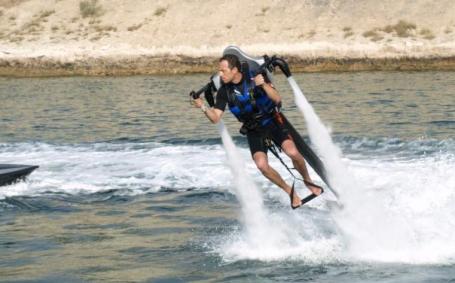
Water-Propelled Jet-Lev Flyer Personal Jetpack Set For Release. Growing tired of your waverunner? Looking to spice things up on your favorite lake this summer? Check out this new "personal jetpack", as described in gizmag.com: "We first came across the water-propelled jetpack from JetPack International early in 2009 and since then the company has changed its name to Jetlev Technologies and teamed up with German company MS Watersports GmbH to get the machine to market. Now the first JetLev R200 jetpacks are set to hit the water, and while it won't let you beat traffic on your daily commute – unless your home and workplace are conveniently located along the same body of water – it does look like a whole lot of fun.Unlike self-contained jetpack designs, such as the famous Bell Rocket Belt and the ducted-fan-driven Martin Jetpack, Jetlev has managed to keep the weight and bulk of the actual jetpack to a minimum by shifting the propulsion engine, fuel and related systems to a small autonomous boat that is tethered to the jetpack and follows the pilot around."
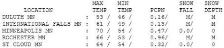

Gray Monday. After a thundery start clouds lingered most of the day, the sun broke through for few hours yesterday afternoon, allowing the mercury to reach 64 at St. Cloud, 70 in the Twin Cities. Rochester picked up nearly 1" of rain Monday, .32" at St. Cloud and .47" in the Twin Cities.

Paul's SC Times Outlook for St. Cloud and all of central Minnesota:
TODAY: Feels like July! Some sun, few severe PM storms possible later, especially central/northern MN. Winds: SE 10-20. High: near 80
TUESDAY NIGHT: Mild and muggy - risk of a thunderstorm. Low: 62
WEDNESDAY: Still warm, passing shower or T-storm. High: 76
THURSDAY: Front stalls - Heavier, steadier rain expected. Low: 54. High: 61
FRIDAY: Cooler, windblown showers and sprinkles - fairly unpleasant. Low: 47. High: 59
SATURDAY: Cool, damp, breezy Walleye Fishing Opener. PM showers. Low: 45. High: 58
SUNDAY: Still unstable, few more showers, mainly morning/midday hours - skies brighten later in the day. Low: 44. High: 61
MONDAY: Finally, a fine (sunny) spring day! Low: 46. High: 66
Local Tornado Alley?
With weather there's never any shortage of myths and old (husband's) tales. Like this one: "There is a local tornado alley that runs across the western & northern suburbs." According to Pete Boulay at the Minnesota State Climate Office, "1965 really skews the data." But if you look far enough back in time, examine raw data, it's impossible to say with any confidence that one part of the metro is more prone to tornadoes than another.
According to SPC the odds your town will be hit are about .021% annually. That means you can expect to see a tornado outside your window every 4,785 years. For EF-2 or stronger: every 6,369 years! I wouldn't lose much sleep; but much like a fire drill, every family should consider a tornado action plan.
A slight risk of severe storms lingers today, mainly north/west of St. Cloud; enough instability, moisture and wind shear for a few (isolated) cases of hail & damaging winds. MOST of us will just enjoy a generic thunderstorm (and highs near 80). Expect watches & warnings close to home later. A front stalls, steadier rain on Thursday. A holding pattern keeps off 'n on showers pasted above our heads into Sunday.
Yep, a cool, damp Fishing Opener. Shocker!
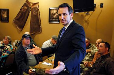
Political Polarization Of Climate Change Is On The Rise. The Christian Science Monitor reports on a trend that has become glaringly obvious, especially in the wake of "Climategate": "Samuel Clemens published under the pen name of Mark Twain. If Al Gore had followed this strategy for "Inconvenient Truth" would we now have passed more aggressive Federal legislation for slowing the growth of greenhouse gas emissions? I do not want to put a heavy trip on the Vice President but the fact remains that there has been a recent divergence between Republicans and Democrats on the issue of climate change and reasonable people can ask "why"? Consider this quote from a recent Republican Presidential Debate from Gov. Tim Pawlenty; "Chris: in January you told me that you signed a bill to promote renewable energy sources, but, and here’s the quote, we never did sign a bill relating to cap and trade in 2007 the bill you signed required a task force to recommend how the state could adopt cap and trade in 2008, you said I support a reasonable cap and trade system at the federal level. You made this ad for the Environmental Defense Action Fund. Let's watch. “If we act now, we can create thousands of new jobs in clean energy industries, before our overseas competitors beat us to it. Cap greenhouse gas pollution, now.” Chris: Governor, I told you it was going to be a problem for you down the line. You now say it was a dumb mistake. Weren't you far more committed to cap and trade over those years than you now let on?"
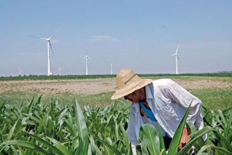
China Leads Push To Go Green. Yes, it seems there's green to be made by going green. The question remains: will we be buying our wind turbines and solar panels from Chinese companies or American start-ups? The jury is still out on that question, as reported by the New York Times: "AMSTERDAM — Denmark earns the biggest share of its national revenue from producing windmills and other clean technologies, and the United States is rapidly expanding its clean-technology sector. But no country can match China’s pace of growth, according to a new report. China’s production of green technologies has grown a remarkable 77 per cent a year, according to the report, which was commissioned by the World Wildlife Fund for Nature. The report was expected to be released Monday at an industry conference in Amsterdam. “The Chinese have made, on the political level, a conscious decision to capture this market and to develop this market aggressively,” said Donald Pols, an economist with the organization. Denmark, a longtime leader in wind energy, derives 3.1 percent of its gross domestic product from renewable energy technology and energy efficiency, the report said, with a total value of about €6.5 billion, or $9.4 billion. China is the largest producer in monetary terms, earning more than €44 billion, or 1.4 percent of its gross domestic product. The United States ranks 17 in the production of clean technologies with 0.3 percent of G.D.P., or €31.5 billion, but those industries have been expanding at a rate of 28 percent per year since 2008."

Renewable Sources of Energy Could Supply 77% Of The World's Energy by 2050, Report Says. An encouraging study, highlighted in this story in the New York Times: "BRUSSELS — Renewable sources could provide a majority of the world’s energy supplies by 2050, but only if governments dramatically increase financial and political support for technologies like wind and solar power, experts from a United Nations panel said Monday. The Intergovernmental Panel on Climate Change said in a report that the availability of renewable sources like the wind and sun was virtually unlimited, and could provide up to 77 percent of the world’s energy needs by mid-century, but governments needed to adopt policies to take advantage of them. “The report shows that it is not the availability of the resource, but the public policies that will either expand or constrain renewable energy development over the coming decades,” said Ramón Pichs Madruga, a member of the I.P.C.C. and the director of an economics research center in Cuba. The report said renewable sources — bioenergy, wind, solar, geothermal, hydropower and ocean energy — currently accounted for about 13 percent of global energy supply."
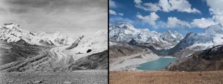
Vatican Science Panel Calls Attention To The Threat of Glacial Melt. Here's an update from the Scripps Institute of Technology in San Diego: "A panel of some of the world's leading climate and glacier scientists co-chaired by a Scripps Institution of Oceanography, UC San Diego researcher issued a report today commissioned by the Vatican's Pontifical Academy of Sciences citing the moral imperative before society to properly address climate change. The co-authors of "Fate of Mountain Glaciers in the Anthropocene" list numerous examples of glacial decline around the world and the evidence linking that decline to human-caused changes in climate and air pollution. The threat to the ways of life of people dependent upon glaciers and snow packs for water supplies compels immediate action to mitigate the effects of climate change and to adapt to what changes are happening now and are projected to happen in the future. "We are committed to ensuring that all inhabitants of this planet receive their daily bread, fresh air to breathe and clean water to drink as we are aware that, if we want justice and peace, we must protect the habitat that sustains us," the authors write in a declaration prefacing the report. "The believers among us ask God to grant us this wish."

The First Rule of Vindicating Climate Science Is That You You Do Not Talk About Vindicating Climate Science. Climate Progress has the story (you probably won't see in any other U.S. media: "UK Government: “It is a primary concern to the Government that the evidence base for policies is robust. Where this evidence base is questioned, it is right that allegations are properly assessed and scrutinised. After two independent reviews, and two reviews by the Science and Technology Committee, we find no evidence to question the scientific basis of human influence on the climate….“Evidence from multiple disciplines and sources strongly indicates that climate change, driven by human activities, poses real risks for our future. This evidence is comprehensively captured in the Fourth Assessment Report of the Intergovernmental Panel on Climate Change (IPCC), and in more recent analyses including from the US National Research Council of the National Academies. It is also clear from an almost continuous body of publications in the academic literature that the evidence for human induced climate change continues to grow….” You won’t find much U.S. media coverage of the official UK “Government Response” to “The Reviews into the University of East Anglia’s Climatic Research Unit’s E-mails” by the Science and Technology Committee of the House of Commons.
I think that is because:
- It re-re-re-re-vindicates climate scientists, and since the media glossed over the first three vindications, why start now?
- It didn’t involve a wedding."

Climate Change Could Disrupt WIFI And Hit Power Supply. It's been a record-breaking warm spring for Britain and much of western Europe - meteorologists are predicting a very real potential for 100-degree heat later this summer. The U.K.'s Telegraph newspaper has the story "Already the transport sector is preparing for temperatures above 104F (40C) this summer, which could lead to breakdowns on the railways. Speaking at Blackfriars Station in London, which Network Rail is currently fitting with solar panels and rainwater harvesting systems in order to be more resilient against power cuts, Ms Spelman said the UK is already investing £200 billion over the next five years. But that will not be enough to stop economic impacts of climate change if it is invested in the wrong areas. She warned of intense rainfall, droughts and heatwaves in the next 50 to 100 years because of man-made global warming. The signal from wi-fi cannot travel as far when temperatures increase. Heavy downfalls of rain also affect the ability of the device to capture a signal. "Our economy is built on effective transport and communications networks and reliable energy and water supplies."

Climate Change: The Next Generation. KQED-TV in San Franciso has a story about how young people are becoming vocal about the need for action: "Young activists are taking to the streets to call for immediate action against change change. Youth turned out in eleven cities across California over the weekend in a series of coordinated demonstrations. Dubbed the i-Matter marches, youth from Eureka to San Diego and from grammar school to college, demanded "climate justice" for their generation. The marches follow a recent lawsuit filed by young people against the Federal government and all 50 states, to force more aggressive reductions of greenhouse gases. “In terms of climate change, the US has basically failed us," said sixteen-year-old Ventura native Alec Loorz one of the lead plantiffs in the suit. “I’m involved in this lawsuit where young people are suing the government for not protecting our right for a livable future and for not protecting our right to grow up in the planet that has sustained all civilization.” This past weekend’s marches might’ve been trumped by Mothers’ Day, as turnout was generally light around the state. Estimates put the San Francisco rally at between 100 and 200 people, while The Sacramento Bee reported that fewer than 100 turned out in Sacramento."

No comments:
Post a Comment