March 21: day when the average high in the Twin Cities is 43 F.
64 F. average high for May 1 at MSP.
Trace of snow flurries reported yesterday (record snow for May 1 is 3" on May 1, 1935, according to the NWS).
40 mph: peak wind gust in the Twin Cities Sunday, average wind speed for the entire day was 19.2 mph.
55 mph: peak wind gust at Canby (Yellow Medicine County) Saturday at 4:16 pm. More peak wind reports here.
May 8, 2010: date of the last reported flurries in the Twin Cities last year (I was surprised too).
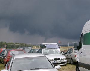
May Day! This was the scene in Minot, North Dakota, on Sunday. WeatherNation meteorologist Todd Nelson sent me this photo from northwestern North Dakota. "Got this photo from family in northwestern ND from the recent blizzard. Nearly 1" rain, 12" snow. No power. All of western North Dakota without power - saying up to 7 days with no power. We're sending generators up to family; no more in stores up there. Reports of 60 mph winds, lot's of drifting, family farmers are upset. They need to get into their fields..."
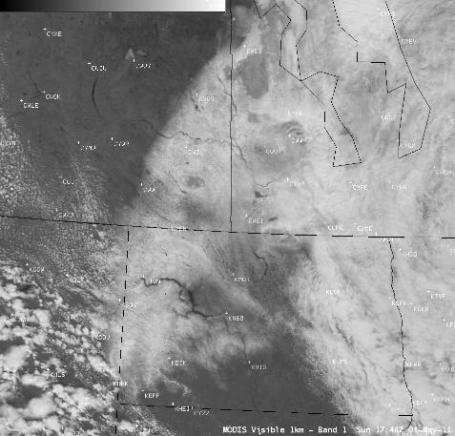
Post-Blizzard Snow Cover In North Dakota and Southern Canada. Here's an update from the University of Wisconsin's CIMSS blog: "A late-season blizzard produced as much as 14.0 inches of snowfall with winds gusting as high as 78 mph across western North Dakota on 30 April 2011, causing power outages and the closure of Interstate 94 from Dickinson to the Montana border. On the following day (01 May 2011), AWIPS images of MODIS 0.65 µm visible channel data (above) displayed a mixture of fresh snow cover and cloudiness across parts of western North Dakota, far southeastern Saskatchewan, and southwestern Manitoba. However, in some areas it was difficult to visually separate the cloud features from the snow cover (although the edges of the snow pack that were quickly melting within the 102-minute time period between the 2 MODIS images were fairly obvious)."
Time Warp. Sunday morning at 10 am I was staring at wind chill readings in the 20s in the Twin Cities, teens over much of northern/western Minnesota. An unusually intense area of low pressure near Winnipeg created a March-like pressure gradient, air accelerating into the center of this low (partial vacuum), whipping up 40 mph+ wind gusts. Our crazy "spring" continues.
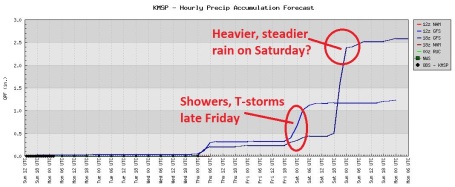
Late-Week Puddle Potential. Models are hinting at a (fast-moving) round of showers Wednesday night, another risk of showers and T-storms by Friday PM. If a storm spins up (as the GFS suggests) steadier/heavier rain may develop on Saturday. Right now odds favor a drier Sunday, but clouds and a cool/damp wind may linger, although probably NOT as cold as yesterday was. What do we have to do to get a springy weekend in here?
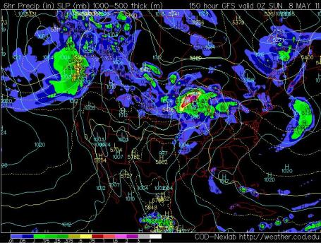
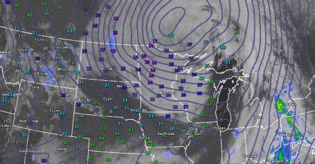
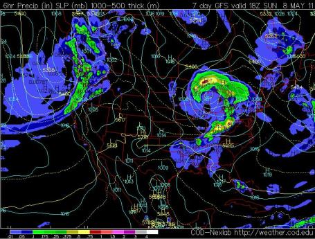
Stormy Saturday? A lot can happen between now and next weekend, but the 18z GFS run on Sunday is developing another fairly significant storm just south/east of Minnesota by Saturday, with a potential for a few hours of steadier, heavier rain. Map above valid next Saturday evening at 7 pm.
Sunday Outlook: Drier (Not Great). By Sunday the bulk of rain should be pushing east into the Great Lakes states. But cool, moist winds on the backside of the storm ("backlash") may spark lingering clouds, sprinkles or drizzle much of the day.
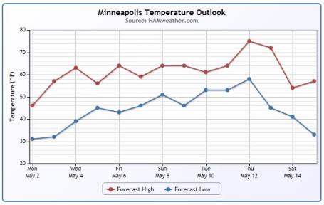
More Like It. After one more cool day (today) temperatures bounce back up to springy levels, highs in the low to mid 60s the latter half of this week, maybe some 70s next week? That would be nice.
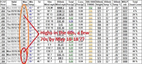
Time To Exhale? Finally some good news wafting out of the weather department: the jet stream is lifting north, dragging milder air north, highs forecast to be consistently in the 60s the second and third week of May, maybe a few 70s by the end of next week? Yes, we're due.
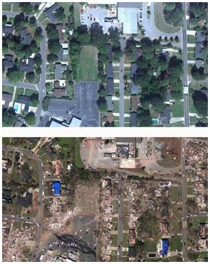
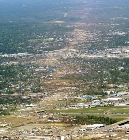
NOAA Releases Aerial Images Of Tuscaloosa, Alabama Tornado Damage. The very latest from NOAA: "NOAA's National Geodetic Survey dispatched the NOAA King Air 350CER aircraft, equipped with specialized remote sensing equipment, on a mission to collect aerial photography at 5,000 feet from Tuscaloosa to Birmingham, Ala. These "before and after" shots (pdf to right), taken yesterday afternoon, show damage caused by last week's tornado near 15th Street and McFarland Boulevard in Tuscaloosa. Photos will be used to assist federal and local officials in response and recovery efforts. Hi-Res images available online.
Image Credit: "Before and after imagery depicting tornado damage in the vicinity of the intersection of 15th St. E. and McFarland Blvd. E. in southeast Tuscaloosa, AL. The before imagery is courtesy of Google, the after imagery was acquired from an altitude of 5,000 feet above ground level by the NOAA King Air April 29, 2011."
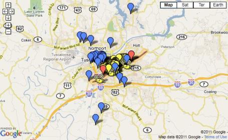
Map Of Tornado Damage And Volunteer Opportunities. An interactive Google map, courtesy of The Crimson White, providing real-time disaster coverage for the state of Alabama.
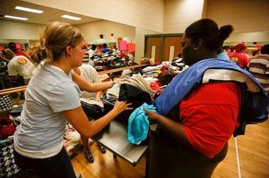
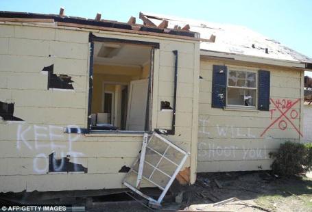
Scope Of Alabama's Tornado-Spawned Humanitarian Crisis Unfolds. Once again the poorest residents were hit the hardest, what little they had ripped away from them in less than 60 seconds as a swirling maelstrom engulfed their homes. The Christian Science Monitor has a story about the logistics involved in housing, feeding (and consoling) thousands of tornado survivors: "In a scene reminiscent of the days following hurricane Katrina in 2005, churches, nonprofit relief agencies, and government supplies are racing toward tornado-raked Alabama to alleviate what Tuscaloosa mayor Walt Maddox described as a "humanitarian crisis." Last week's 200-tornado scattershot across the South became the second deadliest in US history, as the death toll rose to 337. With power still out for nearly 1 million people, hundreds, if not thousands, of homes obliterated and water supplies tainted, Alabamians – including official rescue personnel – struggled for basic needs as the shock of the storms that hit the South on Tuesday and Wednesday began to wear off. "Something as simple as a toothbrush, clothing. There are some people, all they have got is a robe," a Pratt City, Ala. man told reporters. "So, we got to find clothing for them and provide those things for them, so that they can start back rebuilding their lives."
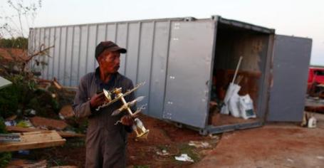
In Tornado Zone, Many Ask, "How Can We Help?" Southern hospitality has been redefined in recent days - the best in people coming out in response to an outbreak of deadly weather last Wednesday, impacting an unimaginable number of people. Thousands were injured, more than 10,000 commercial and residential buildings were severely damaged or destroyed. People are rising to the occasion - showing their southern pride, and what sets them apart, in this New York Times article: "TUSCALOOSA, Ala. — So many contractors showed up at a high school gymnasium here on Saturday that they could not all fit. Even though the death count continued its grim climb upward in what is now the worst tornado disaster in the country since 1925, here at the epicenter people know that the rebuilding has to begin, and quickly. It is hard to imagine what it will take to put life back together in the states torn by last week’s storms. One estimate, by the risk model forecaster EQECAT, put the insured property losses between $2 billion and $5 billion. Still, the contractors were hoping to secure their share of three contracts the city plans to award for the cleanup. People here expect them to be worth tens or hundreds of millions of dollars to a trade still hobbled by the real estate crash and recession. “It’s an awful situation, but this is how we can help,” said Jordan Huffstetler, 29, a general contractor who drove in from Birmingham, Ala."
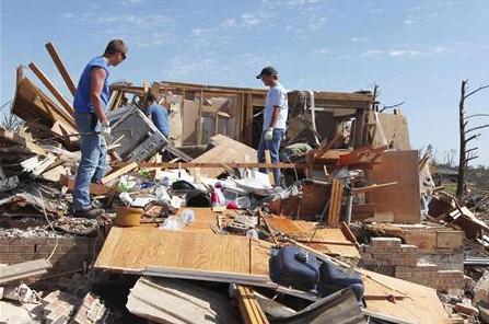
Volunteers Pour Into South After Tornadoes. Reuters has a story about a massive influx of volunteers, all offering to help tornado survivors any way they can: "Unemployed social worker Betty Perry walked out of the Red Cross shelter in downtown Birmingham barefoot after giving her shoes to a woman whose own pair was blown off in the storm. "Someone else needed the shoes more than I do," Perry said on Saturday of her gesture after the devastating tornadoes that swept the South earlier this week and hit Alabama particularly hard. Perry is one of thousands of people who have poured into the battered region, or locals who have volunteered to help clean up. They are offering food and drink, shelter for the homeless and in some cases literally their own possessions. Perry's daughter, Birmingham City Councilwoman Kim Rafferty, worked a 27-hour shift at the Birmingham shelter starting Wednesday afternoon. Perry's friend, Margie Robertson, came straight from her own cancer radiation treatment to sweep the floors and comfort storm victims at the shelter. The tornadoes this week were the deadliest since the Great Depression and have left at least 350 people dead. The devastation is the worst natural disaster in the United States since Hurricane Katrina in 2005.Some people dropped everything as soon as they heard of the disaster and rushed to help."
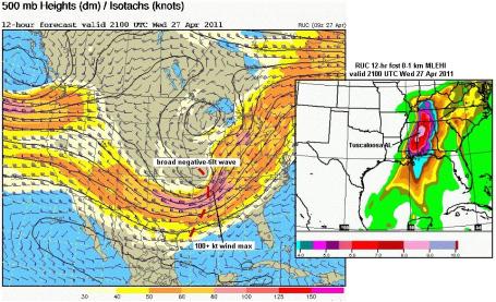
27 April 2011. An Extraordinary Environment For Tornadoes. Jon Davies has a fascinating (fairly technical) post focusing on the atmospheric ingredients present last Wednesday - how ordinary T-storms were able to mutate into violent, "supercells" capable of long-lasting tornadoes: "The Tuscaloosa environment location (large red dot) on the scatterdiagram is quite remarkable! It falls in the center and slightly toward the upper right in the area of most optimum SRH/CAPE combinations for tornadoes. Most telling, there are no points on the diagram to the upper right of the Tuscaloosa point, which makes it rather unique. I've looked through my own databases of tornado cases over the past decade, and can't find any tornado environment that even approaches this one (roughly 600 m2/s2 0-1 km SRH _and_ 3000 J/kg MLCAPE). Typically, if SRH is greater than 500, CAPE is less than 2000 (still a very good environment for tornadoes), or, if CAPE is greater than 3000, SRH is only around 200-300 (yet another very good environment for tornadoes). To have both the SRH and CAPE so large, during daytime heating no less (SRH values are usually largest at night with the low-level jet, when CAPE is not so strong), is quite rare and unusual. Given this information, and the fact that mid-level/500 mb winds were approaching 100 kts on Wedensday (excellent deep-layer shear in addition to low-level wind shear), it is no wonder that tornadoes were strong to violent and on the ground so long. The environment conditions where the storms formed and propagated were probably as optimum as we will ever see!"
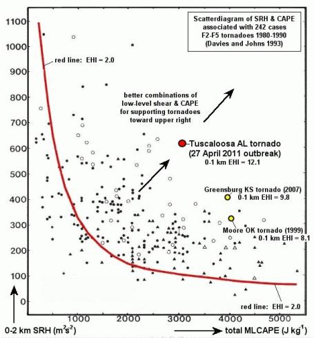
Incredible Numbers. From Jon Davies' post above. This scatter diagram shows the 2 most critical parameters. On the X-axis is "Cape", a measure of instability. Anything over 2,000 is considered extremely unstable, allowing a rising parcel of air to accelerate within a severe thunderstorms. The Y-axis is SRH, or Storm Relative Helicity, a measure of wind shear, how wind speed/direction changes with altitude. Surface winds from the east, winds at 3,000 feet howling from the southeast, winds at 10,000 feet flowing from the south and then "veering" more to the west/southwest 15,000 to 25,000 feet above the ground - under these conditions thunderstorms can spin, rotate, "protecting" and sustaining the warm updraft, allowing the storm to continue to strengthen, an RFD, a "rear flank downdraft" of warm, bouyant, descending air the possible mechanism that pulls the tornadic circulation down to the ground.
Is Climate Change Causing More Tornadoes? A timely question; as much as we want a black & white answer, the truth is probably some shade of gray. Here's the story from greenanswers.com: "No single one of these weather events can be traced to climate change with 100% certainty. In fact, because of the mixture of local conditions that lead to storms, droughts, and flooding, it’s unlikely scientists will ever be able to “prove” a link between extreme weather and human activity. But a NASA study in 2007 predicted climate change would lead to more tornadoes and lethal storms in the United States, and ignoring this warning in light of recent events would seem foolhardy. Whether or not last week’s tornadoes were caused by climate change, extreme weather is on the rise. When you look at a single storm or drought, it’s always possible to find factors besides climate change that might be responsible for what seems like an unusual event. For instance, meteorologists say what appears to be an uptick in US tornado activity could simply be due to improved methods for tracking and recording storms. But last week’s tornado outburst wasn’t something that could have been missed without modern storm-tracking technology. It was an extremely unusual and deadly weather event, and the worst US tornado incident in more than a quarter century. Similarly, Russia’s forest fires last summer were worse than any seen in that country for many decades, if ever. Floods in countries from Australia to Pakistan to Brazil have broken records and caused irreparable damage throughout the past year. Any one of these events might be traced to factors besides climate change. But the overall increase in destructive weather seems undeniable."

Alabama Miracle: Parents Watch As Their 8-Year Old Child Gets Sucked Into A 200 mph Tornado - And Lives To Tell His Story. Not sure if this story has been embellished - almost hard to believe, but here are the details of a remarkable story, a modern-day miracle (?) from the U.K. Daily Mail: "He is the boy who got sucked up into a tornado - and lived to thell the tale. Eight-year-old Reginald Epps Jr. was picked up off his feet and pulled into the swirling darkness when one of the Alabama twisters tore through his home. As his family cowered beneath him he was carried through the air some 30 feet before being set down again with just cuts and bruises. When the wind died down his terrified family looked up to see him walking towards them - and were stunned to see he was still alive."
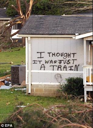
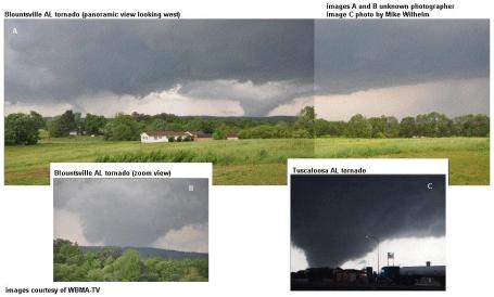
There Are No Words. Images from the Tuscaloosa area, from the U.K. Daily Mail. Here is a post from the wife of James Spann, the (remarkable) veteran TV meteorologist in Birmingham who saved untold lives last Wednesday when multiple (large/violent) tornadoes were on the ground, ripping through heavily-populated parts of his viewing area. He kept his cool, kept information flowing (using Doppler, raw video and social media better than anyone I've ever seen on the air. I thought this was poignant, and important to share:
"We just drove, sun in our faces, until we reached it; the twisted limbs and scattered pieces announcing what was ahead of us. This was the edge of the storm, James told us. We were going in from the side or back of it. I don’t know what was drawing me so desperately to be there, (aside from praying to God with all that is in me that there would be someone I could help, some way, other than just water or food. I think I just wanted to talk and see, and hold a hand. I don’t know.) I don’t know this any more than i know what drives me to write all of this down. If you are reading it, I have chosen to share it. But for now, it is for my own eyes. I don’t understand what I saw today. Black words on white paper may help me to see it more clearly. There has been enough gray. Our 4-Runner is waved through into the area only because James is behind the wheel. Ryan, aged 13, in the back seat. He had been “briefed” as James had put it–as to what he may see or encounter. I do not know what he told him, and secretly hoped that he did not tell him the things which he shared with me. Things I will not write down, nor will I forget. But things that will forever break my heart and remain with me although I only got to see them through my husband’s eyes. I am grateful that he told me these things, and grateful that for the first time he “broke down” as I will forever refer to it that morning at the breakfast table, when the tears finally came. I have not seen my husband cry in a very long time. Go ahead, I thought. Get it out. But they wanted him on the radio upstairs, and he was gone. You would not have known he was hurting to hear him talk moments later. This is my James." (Click here to see the entire post - it's worth your time. Very eloquent and from the heart. Sometimes we, as meteorologists, get so caught up in statistics and weather babble we fail to step gap and grasp the true enormity of nature's rampages. This post helped me regain some sense of true perspective).
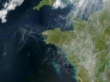
Does Climate Change Mean More Extreme, Deadly Weather And Tornado Outbreaks. A meteorologist I have a lot of respect for, Bob Ryan at WJLA-TV in Washington D.C., has a thoughtful post about what can be attributed to normal, random weather, and where climate change might come in: "So my final answer, at least right now, is that no, not every big weather event, even the April 27 tornado outbreak, is caused by climate change. However, weather is part of climate and climate is part of weather; they are not two distinct things. We know from observations that the earth is now in a general warming period. Will that eventually mean a higher probability of heavy rain events? I think so. Will it mean a higher probability of heavier winter snows, even with a warming world? Sure. A higher probability of slow-moving, persistent patterns of heavy rains, longer droughts and more prolonged heat waves? Yes, I think that's likely. More "super outbreaks" such as April 27? We all sure hope not but because of a number of factors beyond climate and weather something like this is likely to happen again." (photo above from Bob Ryan is of a "mostly cloudy" day over western France - all resulting from jet contrails, one of many ways we alter weather on a day-to-day basis.")
Tornadoes Foreshadowing Hurricanes? One contributing factor to last Wednesday's extreme tornado outbreak: unusually warm water in the Gulf of Mexico, which heightened the instability that ignited a rash of killer "supercell" thunderstorms. Is it possible to connect the dots and predict a more severe hurricane season? All we know is that the number of intense, category 3 or stronger hurricanes has roughly doubled since 1970, especially storms in the Gulf of Mexico (which is shallower than the Atlantic/Caribbean - faster to warm up). Warm water fuels hurricanes, the warmer the water, the greater the potential for rapid intensification. Bradenton.com takes a look at the tornado disaster and asks a tough question: does this foreshadow an extreme hurricane season? "Hurricane season begins one month from today. Six months of dread lies ahead. Forecasts are for 16 named storms, nine of them hurricanes with five major -- category 3 or higher -- packing winds of at least 111 mph. That’s according to hurricane guru William Gray at Colorado State University. I usually take these predictions with a grain of salt, but given the spate of violent weather that’s been going on around us, I wonder whether this pattern will carry over when Florida goes on the clock after June 1. This has been the second deadliest outbreak of tornadoes in U.S. history in more than 60 years. What’s more, approximately 600 tornado sightings were reported in April, eclipsing the record of 267 from 1974. That the warmer-than-usual Gulf of Mexico has helped fuel these tornadoes is ominous. Water temperatures off our beaches will only continue rising. A bathtub, one meteorologist called it. I’m no weather expert, but I know we’ve heard many times over the years how a vast body of warm water -- the Atlantic as well as the gulf -- becomes an engine, a source of energy for a burgeoning tropical system. Not good."

Feeling Lucky? Man Survives Being Struck By Lightning TWICE In Remarkable CCTV Footage. Another eye-opening (hair-raising) story from the U.K. Daily Mail: "The chances of being struck by lightning once are high enough. But one unfortunate man appears to have been electrocuted twice within the space of a minute by two almighty bolts of lightning. The hapless pedestrian had been jogging along a quiet city street when CCTV captured the astonishing moment on April 11. Shortly before the apparent freak accident a walker carrying an umbrella and a jogger had passed through the street unscathed."
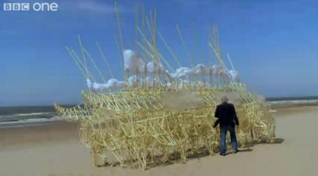
You Have To See This One. Thanks to Tricia Frostad for passing this one along, a video clip from BBC One. It's great to know there are still inventors capable of constructing such an odd and wonderful contraption. I really can't explain this - you just have to see it to believe it. Simply remarkable.

Quality Time, Redefined. Not sure how it works at your house, but at the "Douglas" household CNN is our muzak-of-choice, always on, a background hum of Wolf Blitzer (and fellow WCCO-TV refugee Randi Kaye). We run through our favorite (taped) shows after dinner - the DVR may be the greatest invention ever; the ability to fast-forward through the (inceasingly awful) ads a God-send. Is it just me or do you want to hurl a shoe through your TV when the annoying reporter-dweeb shows up shilling for Nationwide Insurance? Laurie and I are watching the shows, live and taped, with one eye, while clicking away on our laptops, checking our iPhones, grazing with our iPads, both in our own parallel information iHaze, getting "news", information and entertainment on our own terms. The New York Times has more on what family time has mutated into: "IT was a vision of family togetherness out of a Norman Rockwell painting, if Rockwell had worked in the era of WiFi. After a taco dinner one Wednesday in March, Dianne Vavra and her family retreated to the living room of their Cape Cod-style house in Huntington, N.Y., where they curled up on the spacious beige sofa amid hand-stitched quilts as an icy rain pelted the windows. One family. One room. Four screens. Four realities, basically. While it may look like some domestic version of “The Matrix” — families sharing a common space, but plugged into entirely separate planes of existence through technology — a scene like this has become an increasingly familiar evening ritual. As a result, the American living room in 2011 can often seem less like an oasis for shared activity, even if that just means watching television together, than an entangled intersection of data traffic — everyone huddled in a cyber-cocoon. Call it what you will, it is a wholly different form of quality time."
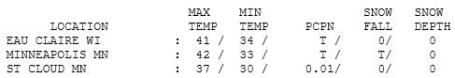

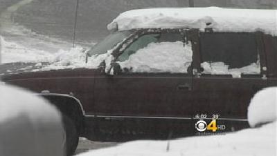
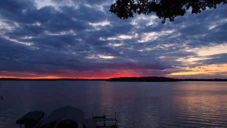
A Thoroughly Forgettable Sunday. Sprinkles and flurries on May 1? The recorded high of 42 was more typical for the third week of March. Highs ranged from 35 at Alexandria to 37 at St. Cloud and 48 at Redwood Falls.
Paul's SC Times Outlook for St. Cloud and all of central Minnesota:
TODAY: Mostly cloudy, still chilly for early May. Less wind than yesterday, but still breezy. Winds: NW 10-20. High: 45
MONDAY NIGHT: Partial clearing, frost in the suburbs. Low: 31
TUESDAY: More sun, real hints of spring. High: 59
WEDNESDAY: Clouds increase, showers arrive late. Low: 41. High: 62
THURSDAY: Intervals of sun, PM showers north. Low: 46. High: 63
FRIDAY: AM sun, PM showers possible. Low: 45. High: 65
SATURDAY: Partly sunny, the better day of the weekend? (PM showers far northern/western MN). Low: 47. High: 66
SUNDAY: Slightly cooler, some sun possible early. Unsettled, passing showers possible. Low: 45. High: 58

Crazy Cycles
Life, like the weather, is cyclical. The moments of joy and euphoria don't last; neither do the dark times and pain all of us experience. We lost our 15 year old dog, Max, last Friday. He was part of our dysfunctional family. We miss him very much.
We're all due for a break, a shift in the pattern. 1). The most snow since 1984. 2). Flurries on May 1. What the heck?
Friend & neighbor, Dave Arundel, summed up a growing sense of weather-frustration. "This morning I was looking in the paper for some place in the U.S. with SUN. I told my wife we may have to fly somewhere for a couple days just to experience the sun and over 70 degrees. I am not kidding!" I feel your pain, Dave.
Sunday was typical for mid March. Wind chills in the 20s on May 1? Good grief. CPC, the Climate Prediction Center, predicts a bias toward cooler than average temperatures into July. But we WILL have a real summer. Right?
60s return by Tuesday, a shot at 70 by the end of the week. The best chance of rain comes Wednesday night and Friday night - a few pop-up showers Sunday afternoon. A little mild sun is possible Saturday afternoon & early Sunday; no end to our cool and stormy pattern through mid May.

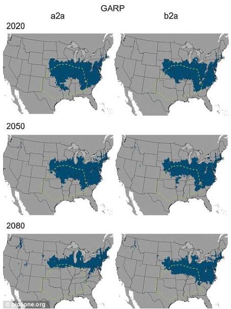
Terrifying Brown Spiders Moving North With Global Warming. Just what you want to read on a Monday. Good.com has the story. Man, I hate spiders: "My colleague Liz has been begging—seriously begging!—me to warn the American public about the growing threat of the terrifying and deadly brown recluse spider. Researchers have founds that the range of this extraordinarily venomous spider—a bite from which can, in some cases, kill—is expanding due to climate change, and that they'll be moving farther north to more populous parts of the country. "The actual amount of suitable habitat of the brown recluse doesn't change dramatically in the future time slices, but what is changing is where that area is located," said Erin Saupe, a researcher from the University of Kansas. Here's the map. The green dotted line marks current habitat. The blue masses are the areas they're expected to move to as temperatures increase."
More and more people now go to www.55thCrossing.com to search for the best home there is in Minot.
ReplyDeleteAlways look forward for such nice post & finally I got you. Really very impressive post & glad to read this.
ReplyDeleteWeb Development Company in Greater Noida
Software development company In Greater noida
Always look forward for such nice post & finally I got you. Thanks for sharing this content.
CMS and ED
CMSED
Homoeopathic treatment for Psoriasis in greater noida
Kidney Disease Homoeopathy Doctor In Greater Noida
Best content & valuable as well. Thanks for sharing this content.
ReplyDeleteApproved Auditor in DAFZA
Approved Auditor in RAKEZ
Approved Auditor in JAFZA
i heard about this blog & get actually whatever i was finding. Nice post love to read this blog
Approved Auditor in DMCC
Virgin Linseed Oil BP
Good luck & keep writing such awesome content.
ReplyDeleteBest dental clinic in Faridabad
best child dentist in greater Noida