+.1 F. average April temperatures in St. Cloud were roughly a tenth of a degree F. warmer than average at KSTC.
.46" rain predicted for Thursday (NAM model).
.68" rain predicted for Friday night into Saturday morning (GFS model).
.24" rain forecast for Sunday afternoon/evening in the metro area.
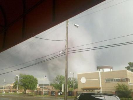
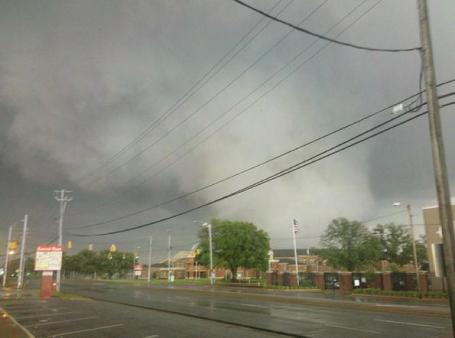
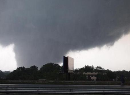
362 tornadoes reported in last week's tornado outbreak (SPC).
312 tornadoes in one 24 hour period, the most ever observed in the USA.
340 fatalities: deadliest 24 hour period for tornadoes since the "Tri-State Tornado" on March 18, 1925.

Tornado Update From The Associated Press: "Washington - Preliminary government estimates say there were more tornadoes in a single day last week than any other day in U.S. history. Government analysts said Monday there were 362 tornadoes during last week's outbreak, including a record-setting 312 in one 24-hour period. The National Oceanic and Atmospheric Administration said the largest previous number on record in one event occurred from April 3-4, 1974, with 148 tornadoes. NOAA says 340 people were killed during the 24-hour-period from 8:00 am Wednesday to Thursday. It was the deadliest single day for tornadoes since the March 18, 1925, tornado outbreak that had 747 fatalities across 7 states."
The April 26-28 period had the most people killed by tornadoes in a two-day period since April 5-6, 1936, when 454 people were killed, mostly in Tupelo, Mississippi, and Gainesville, Georgia.
April 27, 2011, is the deadliest single day for tornadoes since the March 18, 1925, tornado outbreak that had 747 fatalities across 7 states (including the Tri-State Tornado).
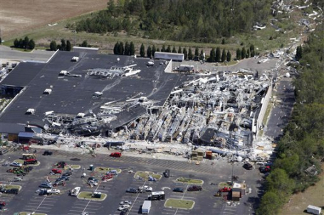
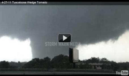
The Tuscaloosa-Birmingham tornado during the April 2011 event caused at least 65 fatalities. This tornado had a maximum width of 1.5 miles and a track 80 miles long.
These are the most fatalities from a single tornado in the United States since May 25, 1955, when 80 people were killed in a tornado in southern Kansas with 75 of those deaths in Udall, Kansas.
The deadliest single tornado on record in the United States was the Tri-State tornado (Mo., Ill., Ind.) on March 18, 1925, when 695 died.
Ongoing (preliminary) List of Tornadoes by EF Rating (EF3 to EF5):
EF-5: 2
EF-4: 11
EF-3: 21
Note: All numbers are based on combined NOAA and historical research records and current fatality estimates. The historical research records extend back to 1680.
Data is preliminary and subject to revision
Month of April 2011 (and record monthly) Tornado Statistics
NWS’s preliminary estimate is that there have been more than 600 tornadoes thus far during the month of April 2011.
The previous record number of tornadoes during the month of April was 267 tornadoes set in April 1974.
The previous record number of tornadoes during any month was 542 tornadoes set in May 2003.
The average number of tornadoes for the month of April during the past decade is 161.
The overall monthly average number of tornadoes for the past decade is 106.
2011 Year-to-Date (and record annual) Statistics
NWS’s preliminary estimate is that there have been 881 tornadoes so far this year.
The previous yearly record number of tornadoes was set in 2004 with 1,817.
May is historically the most active month for tornadoes.
The overall yearly average number of tornadoes for the past decade is 1,274.
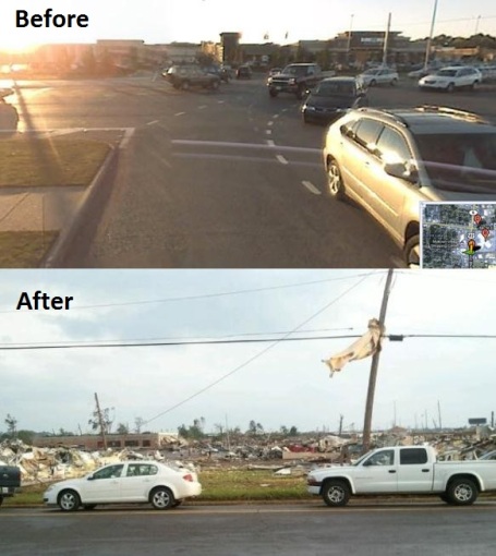
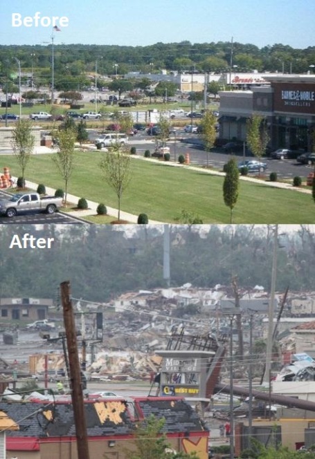
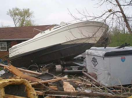
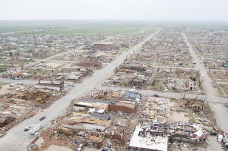
* Remarkable before/after photos from Tuscaloosa below. More images at buzzfeed.com.
Storm Damage Likely To Increase Insurance Rates. I have a hunch all of us will be paying more for property insurance in the coming years as the frequency and intensity of extreme weather events continue to ramp up. This (global) trend is likely to hit all of us in the wallet. Fayobserver.com has the story: "Property insurance rates likely will rise across North Carolina because of the devastation from the April 16 tornadoes, industry officials say. But the increase probably would be less than 5 percent, and it wouldn't take affect until at least 2013, according to the North Carolina Rate Bureau. "We feel that people should not be worried that there will be a huge homeowner's insurance rate increase because of the tornadoes," said Kerry Hall, a spokeswoman for the North Carolina Department of Insurance, which regulates and sets insurance rates for the state. 50-year average: Insurance companies compute damage from tornadoes, strong winds and hail against a 50-year average. And because weather like that could occur anywhere, at any time, damage estimates are averaged across the entire state, said Ray Evans, the general manager of the Rate Bureau, which represents insurers."
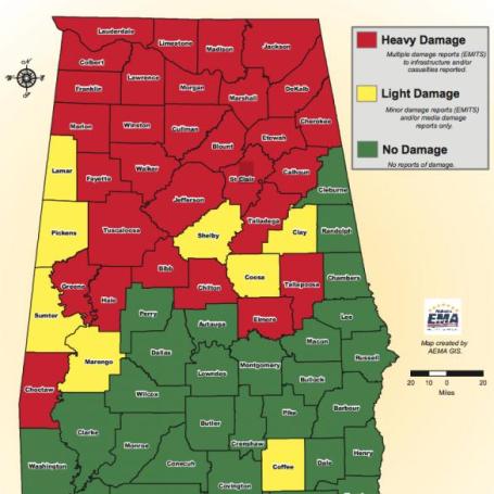
Widespread Alabama Tragedy. From Birmingham TV meteorologist, James Spann's, weather blog: "This map from the Alabama Emergency Management Agency says it all…If you live in a green county, consider yourself fortunate and blessed."
Storm Survivors Turn To Faith And Feds. Here's an article from msnbc.com: "BIRMINGHAM, Ala. — Southerners turning to their faith to make sense of the devastation left behind by the second deadliest tornado outbreak in U.S. history also will be counting on the federal government for help, which Obama Cabinet members assured would come quickly. Homeland Security Secretary Janet Napolitano toured hard-hit neighborhoods of Alabama and Mississippi on Sunday to offer condolences and pledge support. "This is not going to be a quick comeback or an immediate (recovery) but it will be, in my view, a complete one," she said in shattered Smithville, Miss., where little was left standing."
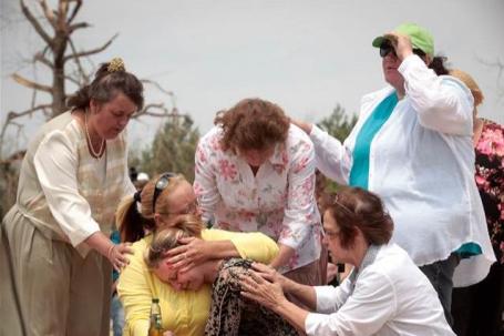
Photo Credit Above: "Teressa Lambert, second from left, comforts her daughter Rachael Gaudio during a Sunday church service, May 1, at the site of the Phil Campbell Church of God, destroyed in a deadly tornado April 27, in Phil Campbell, Ala. Top government officials planned to survey the devastated landscape left by tornadoes in the South on May 1, as President Barack Obama's administration tries to show it is on top of the deadliest U.S. natural disaster since Hurricane Katrina." (Lee Celano / Reuters).
Meteorologist James Spann Attributes Success Of Tornado Coverage To Amateur Videographers. The TV coverage James Spann provided to Alabama viewers was examplary - no question in my mind that Spann (personally) saved many lives. Here is a story from MediaBistro's TVSpy: “If you can show a live tornado with a camera, there’s no doubt that people will react in a more urgent way,” said ABC 33/40 meteorologist James Spann, whose in-depth coverage of Alabama’s brutal tornadoes has been admired by newsers across the country this week. In a recent interview with The New York Times, Spann said that live video of the tornado system, much of it shot by volunteers, made the difference in ABC 33/40′s (WCFT-WJSU-WBMA) coverage. Here’s the Times: Live video of tornado touchdowns is a relatively new phenomenon, one that has been made possible by extensive mobile access to the Internet. In Birmingham, WBMA recruits and trains volunteers to follow severe thunderstorms and act as spotters, complete with dashboard cameras linked via the Internet to the station. “They’re just like an extension of what we do,” Spann said of the volunteer videographers."
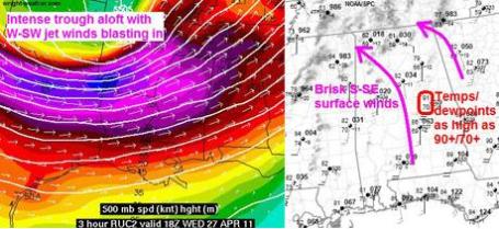
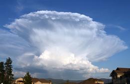
The "Katrina" Of Tornado Outbreaks. The Weather Channel's Stu Ostro has an interesting post about the convergence of meteorological factors that caused the largest outbreak of tornadoes the USA has ever experienced: "I posted that graphic last Wednesday afternoon on my TWC Facebook page. The ingredients were "textbook." I mean, literally what I learned from a textbook more than 30 years ago. The atmosphere was explosively unstable with summerlike heat and humidity, interacting with a classic wind shear setup as a strong jet stream and upper-level trough crashed overhead. Also, dry air aloft (dark red shades on the left image below) put a lid on things and allowed the energy to build up until it blew sky high. Not only were the elements perfect for a tornado outbreak, they were present to an extreme degree. The observed EHI ("Energy Helicity Index"), a measure which represents a combination of instability and wind shear, was extraordinary, higher than during the time of two notorious [E]F5s, the Moore, Oklahoma and Greensburg, Kansas tornadoes on May 3, 1999 and May 4, 2007, respectively. Such a set of combustible ingredients, plus a remarkable number of supercells with hook echoes on radar and "ground-truth" observations of tornadoes, led Dr. Forbes and me to decide to up TWC's "TOR:CON" index to a 10 for northern Alabama, meaning a 100% chance of a tornado within 50 miles, the first time that's been done since the product was developed a couple of years ago."
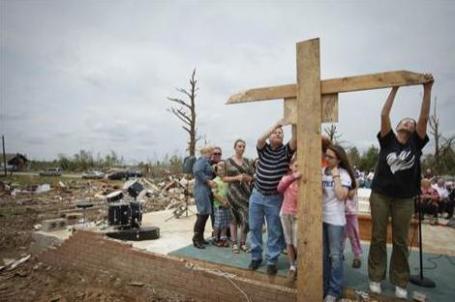
Redefining The Meaning Of Faith. "Worshippers sign a makeshift crucifix folowing a Sunday church service at the site of the Phil Campbell Church of God in Phil Campbell, Alabama." Photo courtesy of Reuters and msnbc.com.
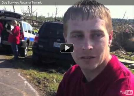
Feel-Good Video Of The Day, Tornado Edition. Here's a (rare), uplifting story from TVSpy:"ABC 33/40 captured more than just frightening live images of severe weather this week, as a tornado system ripped through Alabama. They also uncovered this story (above) about a puppy that was discovered buried underneath rubble. Auh!"
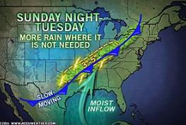
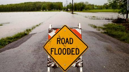
More Rain For Already-Flooded Arkansas, Ohio Valley. On Sunday one town in Arkansas picked up over an inch of rain in 17 minutes. A stalled front is compounding and prolonging the weather-headaches for much of the Middle Mississippi and Ohio River Valleys. More from Accu Weather here: "More flooding is inevitable from Arkansas to the Ohio Valley since the already water-logged region will not be able to handle the additional rain that will pour down through Tuesday. The potential exists for an additional 3 to 5 inches of rain to soak the corridor from northeastern Texas to the Ohio Valley through Tuesday. For places from central Texas to western Tennessee, some of this rain came in the form of severe thunderstorms. That amount of rain would alone raise concerns for flash flooding. But with the ground already saturated and rivers severely flooding, new flooding issues are inevitable. Residents in low-lying, poor drainage and urban areas can expect the return of flood waters. Small streams that may have receded during the recent brief dry spell should once again overflow their banks. Flooding along already swollen large rivers will worsen, heightening the potential for more levees to fail."
* The Little Rock, Arkansas area has seen over 11" rain in the last 8 days. Some suburbs picked up over 1" of rain in 17 minutes on Sunday.
Lower Mississippi River Flooding Could Set Records. USA Today has the story: "As the record floodwaters from the Ohio River pour into the Mississippi — and are joined by meltwater from this winter's record snowpack over the Upper Mississippi — all-time flood heights are likely to be exceeded at many points along a 400-mile stretch of the Mississippi below its confluence with the Ohio, Weather Underground meteorologist Jeff Masters reports. Mississippi River flood records go back about 100 years. AccuWeather meteorologist Alex Sosnowski says water levels along the Mississippi River from southern Illinois and southeastern Missouri to western Tennessee and northeastern Arkansas are forecast to eclipse record levels set during the late-winter flood of 1937. Extreme amounts of rain caused by a stagnant, persistent weather pattern have drenched much of the region over the past couple of weeks, says hydrologist Jim Noel of the Ohio River Forecast Center in Wilmington. "One to 2 feet of rain has fallen in the Ohio Valley and mid-Mississippi Valley," Noel says. This is four to six times as much rain as the area normally sees, he says. Noel says heavy rain in this area is typical of a La Niña climate pattern, which the USA has been in throughout the winter. La Niña, a periodic cooling of central Pacific Ocean water, affects weather patterns around the world."
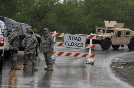
Engineers Will Blow Up Missouri Levee, Official Says. CNN has the latest: "The U.S. Army Corps of Engineers will blow up a levee at the confluence of the Mississippi and Ohio rivers due to record high-water levels in both rivers, with work beginning Monday night, said Maj. Gen. Michael Walsh, president of the Mississippi River Commission. At 4 p.m. Monday, water levels outside Cairo, Illinois, were 61.4 feet - well above the flood stage of 40 feet - according to the National Weather Service. Walsh ordered the intentional breach to alleviate pressure in the river system and to protect Cairo, even though it may lead to the flooding of 130,000 acres of mostly farmland in Missouri. Missouri officials have been fighting the proposed levee breach."
Flood Update. Thanks to Jame Aman from Earth Networks for passing this on:
The Mississippi River at the city Cairo IL (southern tip of Illinois) has continued to climb, and is now a full 2 feet above its record stage ! See:
In the ongoing battle between Missouri & Illinois, the U.S. Supreme Court has declined to intervene, and so now the U.S. Army Corps of Engineers will blow up the levee on the Missouri side of the river, across from Cairo IL. The hope is that this will save the flood-walls around Cairo IL, but it will flood almost an entire county in Missouri:
AP story:
Reuters story:
It appears that this “Bird Point levee” will be blown up Corps of Engineers sometime later this evening.
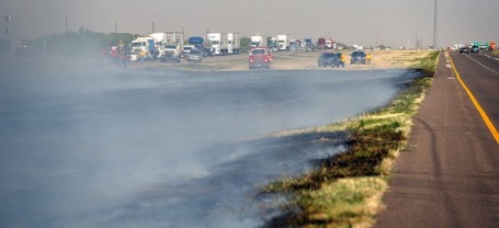
Weather Conditions Are Ripe For Wildfires. Here's a story from the Des Moines Register: "Dry and windy conditions could create potential for more grass fires early this week, according to the National Weather Service. Though the Des Moines area is about an inch above average for annual precipitation, meteorologist Kevin Skow said that slow plant growth has created conditions susceptible to grass fires. "The soil moisture is in fairly good shape, but things are a little slow to get growing because of cold mid- to late-April temperatures. That left us with a lot of dry, dead vegetation on the ground from last year," Skow said. Crews from the Des Moines, West Des Moines, Norwalk and Northern Warren fire departments struggled Saturday to put out a fire in Des Moines' Water Works Park after sparks from a passing train set between 30 and 40 acres of grassland ablaze. Capt. Steve Brown, a spokesman for the Des Moines Fire Department, said that the department doesn't deal with wildfires often, but that mutual aid agreements assure that Des Moines firefighters are prepared."
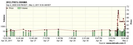
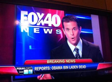
Tracking Obama's Numbers. A friend e-mailed me this link - hour by hour popularity numbers for President Obama. Note the spike Sunday night as the announcement of Bin Laden's death reached the public.
40 Minutes That Changed The World: Inside The Operation That Brought Bin Laden Down. ABC News has a terrific summary of how Sunday's operation went down: "It began with a tip to the CIA eight months ago about a possible Bin Laden hiding place, and led Sunday to the bold military operation that will go down in U.S. history. Osama Bin Laden wasn't hiding in a cave, but in a Pakistani city of 90,000 called Abbottabad, just north of the Pakistani capital. Tracking one of the Al Qaeda leader's trusted couriers, the CIA discovered an acre-large, million-dollar compound with 12 to 18-foot walls that had no telephones but was eight times the size of other homes in the area and just off a major highway. President Obama gave the order for a small team of U.S. Navy SEALs in Afghanistan to go in Sunday night Pakistan time, even though bin Laden had never once actually been seen in the compound. "I determined that we had enough intelligence to take action," said President Obama in a nationally televised address Sunday night, "and authorized an operation to get Osama bin Laden and bring him to justice."

Bin Laden "Goes Down Firing." The Star Tribune has more details about the firefight: "Bin Laden went down firing at the Navy SEALs who stormed his compound, a U.S. official said. Brennan said one of bin Laden's wives was used as a human shield to try to protect him and she was killed, too, as a result. Brennan, speaking of bin Laden, said that revealed "the nature of the individual he was...The official said two dozen SEALs in night-vision goggles dropped into the high-walled compound in Pakistan by sliding down ropes from Chinook helicopters in the overnight raid."
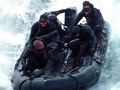
Meet "Seal Team 6": The Bad-Asses Who Killed Bin Laden. Here's some amazing background information on the elite (Navy Seal) team that took Bin Laden out, from businessinsider.com:
"The military team that killed Osama Bin Laden is an elite special forces group unofficially called Seal Team 6. Officially, the team's name is classified and not available to the public, technically there is no team 6. A Tier-One counter-terrorism force similar to the Army's elusive Delta group, Team 6's mission rarely make it to paper much less the newspaper. It shows how important the publicity about Bin Laden's killing is to the U.S. that this morning, Team 6 is front pages news. The members of Team 6 are all "black" operatives. They exist outside military protocol, engage in operations that are at the highest level of classification and often outside the boundaries of international law. To maintain plausible deniability in case they are caught, records of black operations are rarely, if ever, kept. The development of SEAL Team 6 was in direct response to the 1980 attempt to rescue the American hostages held in Iran. The mission was a terrific failure that fell apart at many points and illustrated the need for a dedicated counter-terrorist team capable of operating with the utmost secrecy. The Team was labeled 6 at the time to confuse Soviet intelligence about the number of SEAL teams in operation at the time. There were only two others."

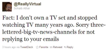
On Social Networking Sites, Presidential Mystery Does Not Wait For The President. Once again Twitter got a jump on the networks. Rumor, innuendo, and hints of Bin Laden's death before the news became official. Brian Stelter from the New York Times has more details on how the evening unfolded on the 'net: "The terse announcement came just after 9:45 p.m. Sunday from Dan Pfeiffer, the White House communications director. “Potus to address the nation tonight at 10:30 PM Eastern Time,” he wrote on Twitter, sharing the same message that had just been transmitted to the White House press corps. According to Brian Williams, the “NBC Nightly News” anchor, some journalists received a three-word e-mail that simply read, “Get to work.” The nation’s television anchors and newspaper editors did not know, at first, that President Obama would be announcing the death of Osama bin Laden, an extraordinary development in the nearly 10-year war against terrorism waged by the United States and its allies. But reporters in Washington suspected almost immediately that the announcement could be about bin Laden. That speculation was not brought out on television immediately, but it did erupt on Twitter and other social networking Web sites. Wishful thinking about bin Laden’s death ricocheted across the Web — and then, at 10:25 p.m., while Mr. Obama was writing his speech, one particular Twitter post seemed to confirm it. Keith Urbahn, the chief of staff for the former defense secretary Donald Rumsfeld, wrote at that time: “So I’m told by a reputable person they have killed Osama Bin Laden. Hot damn.”

Ground Zero Cameras. No, we will never forget. Earthcam has live streaming cameras from "Ground Zero" in Lower Manhattan: "To the families, friends, rescue workers and all those affected by the horrific events of September 11th we extend our heartfelt condolences. In memory of these fallen heroes: WE WILL NEVER FORGET. One prominent reminder of the scale of the disaster that engulfed New York on September 11th is the remains of "The Sphere", which stood in the fountain that was once the centerpiece of World Trade Center plaza, which sat for many days amidst the ruins, and was visible on our camera."
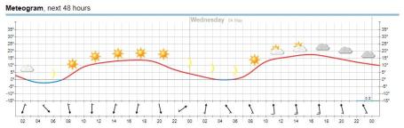
Meteogram. The sun should be out today and the first half of Wednesday, clouds increasing during the afternoon tomorrow, a slight chance of showers by Wednesday night.
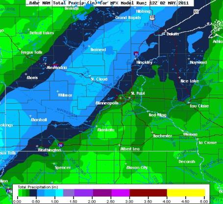
Wednesday Night - Thursday Rain Event. The NAM prints out nearly half an inch of rain for the northern and western suburbs by Thursday, closer to 1" rain from near Marshall to St. Cloud, Brainerd and Hibbing.
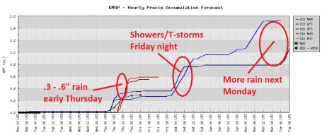
Stormy Pattern. Front #1 arrives Wednesday night with anywhere from .3 to .6" rain, another spirited round of showers (and possible thunder) Friday night into early Saturday, yet another round of showers/storms possible next Monday. Rain events are spaced about 36-48 hours apart.
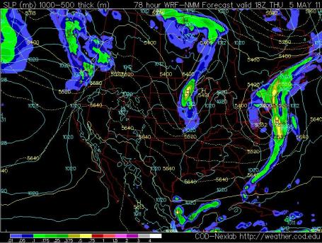
Showery Thursday? A dry sky is all but assured today into most of Wednesday, a slight chance of showers arriving from the Dakotas late Wednesday night into Thursday, as another trough of low pressure (a wrinkle of unusually cold air aloft) drifts over Minnesota.
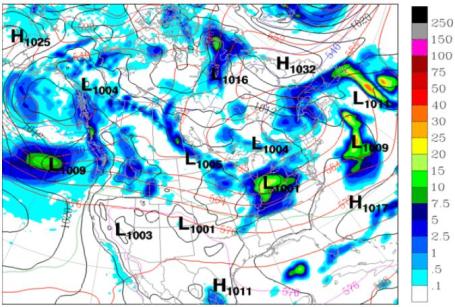
Saturday In Doubt. What do we have to do (who do we have to bribe?) to salvage a nice spring weekend? It's too early to panic (much), but all the models push showery rains, even a few embedded T-storms across Minnesota late Friday into Saturday. Probably not an all-day rain, but a few hours of showers. Right now Sunday looks marginally drier, but a passing shower or T-shower can't be ruled out Sunday as well. Yes, we're stuck in a fast-moving, stormy, cooler-than-average weather pattern.
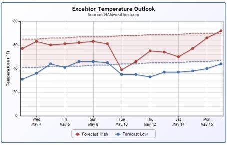
Ever Upward (With A Few Exceptions). The long-range temperature trend shows temperatures just a couple degrees cooler than average for much of this week, followed by a quick cooling trend ealry next week, even a shot at 70s by May 16-17. We'll see. To see the trend for your own hometown just plug your zip code into this site, courtesy of Ham Weather.
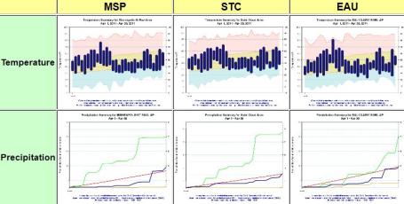
April Climate Summaries. The local National Weather Service has a good summary of April, for the Twin Cities, St. Cloud and Eau Claire here. A summary of the summary: "Detailed climate summaries are now available for the month of April (links and images below). In what seemed a very cold month, temperatures across the area actually averaged near normal. Temperatures the first 12 to 13 days of April were at or above normal. However, the remainder of the month was cold with many days around 10 degree colder than would be typical for mid to late April. Precipitation was near normal in Eau Claire and St. Cloud, while the Twin Cities recorded around a half inch more than normal. All three stations recorded around 2 inches of snowfall during April."
April in the Twin Cities
+8.3 F warmer than average for the month.
2.32" rain (and melted snow). That's .01" more than average for April.
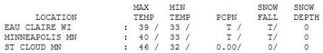

Unreasonably Cool. With a May like this who needs March? "High" ranged from 39 at Eau Claire and St. Paul to 40 at MSP International, 46 at St. Cloud (where the sun came out by late afternoon), and a balmy 46 at Redwood Falls. That's 20-25 degrees cooler than average for May 2.
Paul's SC Times Outlook for St. Cloud and all of central Minnesota:
TODAY: Frosty start. Bright sunshine returns! Better. Winds: NW 7-12. High: near 60
TUESDAY NIGHT: Crystal clear, still cool. Low: 35
WEDNESDAY: Plenty of sun. Feels like spring again. High: 65
WEDNESDAY NIGHT: Clouds increase, chance of showers late. Low: 48
THURSDAY: Cool breeze. Lingering showers. High: 61
FRIDAY: Some fleeting sun, few PM T-storms? Low: 44. High: 65
SATURDAY: Unsettled, few hours of showers possible. Low: 46. High: 63
SUNDAY: Peeks of sun, stray shower or T-shower? Low: 45. High: 64
MONDAY: More showers, storms at night. Low: 47. High: 63
May Day!
Welcome to May. As in "it MAY warm up one of these days." I've gone from meteorologist to would-be therapist. "Paul, I'm feeling blue - the weather has me in a funk. Is there an app for that?" No. But today will heal those numb, slightly frostbitten psychic weather-wounds. The sun peeks through, winds ease. You may actually want to spend a little time in your yard. What a concept.
May is a fickle month: an average of 3.24" (almost an inch more than April), 5 days with thunder is "normal", odds also favor a couple of tornadoes in Minnesota by the end of the month. Just looking at the trends down south leads me to believe it's going to be another very busy year for severe weather in Minnesota.
A fairly stormy pattern is shaping up, a band of showers Wednesday night into Thursday, another round of T-storms late Friday, with showery rains spilling over into Saturday. A sunny start Sunday may give rise to yet another round of T-showers Sunday. No need to water the lawn anytime soon. No snow. No more wind chill. No severe storms imminent. Finally, the (preliminary) tornado count from the April 27 super-outbreak has risen to 267. A La Nina-powered fluke, or the "new normal"?
California Gambles On Carbon Trade. Here's a Monday article in the New York Times. Once again California is on the leading, bleeding edge of attempting to put a price on carbon pollution: "WASHINGTON — California is putting its reputation as a pioneering environmental heavyweight on the line as it prepares to establish a carbon market in eight months. State regulators are battling the clock, the courts and their own empty pockets as they prepare to oversee the start of the multibillion-dollar market Jan. 1. The idea of capping greenhouse gas emissions and providing cleaner companies with the potential for profit from their success is not new, but it has never been tried in the United States on this scale. “This is by far the most ambitious program to reduce greenhouse gas emissions in North America, and by some measures the world,” said Franz Litz, a senior fellow at the World Resources Institute."
* Canada's Globe and Mail has another story focused on California's experiment here.
"The climate is an angry beast, and we're poking it with sticks."
- Wally Broecker, 1991
Greenlandic Writer Brings Climate Change To Youth. "Kids Don't Understand It." Nunatsiaqonline.com has the story: "Climate change remains an issue which raises mixed feelings among Greenlandic people she said. They’re faced with the prospect of huge oil developments, a rush of “black gold,” which will bring with it riches and social change. The future in store for the island feel more important than clamping down on climate-warming greenhouse gas emissions, Hansen said. But changing consumer behavior is just as important in Greenland as in larger industrialized nations, “so we face a dilemma,” she said. Many in Greenland are also so tired of hearing doomsday stories or highly scientific information about climate change that they just let environmental news flow in one ear and out the other, Hansen said. But Hansen isn’t discouraged."
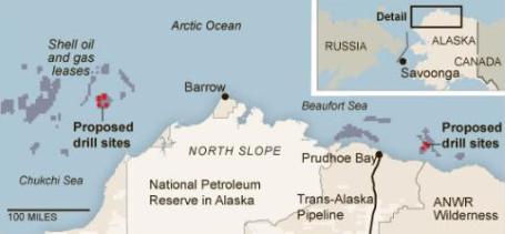
Shell Tries To Calm Fears On Drilling In Alaska. As the price of a gallon of gasoline surges toward $5 gallon there will be increasing pressure to drill in the Arctic region. The New York Times takes a look at current trends: "SAVOONGA, Alaska — Shell Oil will present an ambitious proposal to the federal government this week, seeking permission to drill up to 10 exploratory oil wells beneath Alaska’s frigid Arctic waters. The forbidding ice-clogged region is believed to hold vast reserves of oil, potentially enough to fuel 25 million cars for 35 years. And with production in Alaska’s North Slope in steep decline, the oil industry is eager to tap new offshore wells. Shell has led the way, working for five years to convince regulators, environmentalists, Native Alaskans and several courts that it could manage the process safely, protect polar bears and other wildlife, safeguard air quality for residents and respond quickly to any spill in the region. But BP’s Deepwater Horizon disaster a year ago put a chill on new offshore drilling. Shell’s renewed application will pose a test for President Obama, who promised to put safety first after the BP spill. But he has also reiterated his support for offshore drilling amid voter worries about rising gasoline prices. Environmental groups say a spill in the Arctic’s inaccessible waters could be even more catastrophic than the Gulf of Mexico accident. Republicans, meanwhile, are threatening to excoriate the president for turning his back on energy security if he says no to Shell."

Birther Debate Dead, Could Climate Change Be Next? I have a theory that Donald Trump is single-handedly responsible for global warming - all the hot air coming out of that guy's mouth. Just a hunch. Triplepundit.com has the story: "Good old Donald Trump. We all know there is no way he will ever be President of the U.S. and I think he knows it too. But that doesn’t mean he can’t use his media smarts to grow his brand. Mr. Trump managed to briefly make a media storm out of something I had hoped we had buried a long time ago. The validity of Obama’s birthplace. By recycling an old conservative tactic in the run-up to the 2008 elections, Donald Trump may have managed to score one for the opposing team, the Obama camp. That is because Obama’s team finally had enough of this debate and in the span of a few days, shut it down by getting the long-awaited “long-form” version of his birth certificate from Hawaii. I know I am an eternal optimist, and you’ll have to bear with me for a minute, but I am seeing an even more silver lining in the closing of the great birther debate. As I see it, this could be the beginning of the debunking of many attempts by the hard right to circumvent truths we all know to be self-evident. Surprisingly I have lots of very conservative friends and business associates who steadfastly supported the notation that Obama was in fact born in some other country, despite all of the prior evidence to the contrary. What most of us already know is that there are a relative minority of people with agendas who seek to raise doubt in the voter’s minds about all kinds of topics that should be beyond reproach based on the real evidence. And for some reason this seems to work more often than not in North America while other parts of the world are more immune to these efforts."

Can A $300 House Save 2 Billion People Living In Poverty? Mashable.com has the story:
"Can the world’s business leaders apply their creativity and financial acumen to help pull 2 billion people out of poverty? That’s the challenge put forth by a Dartmouth professor and a veteran marketer, who are soliciting designs for a $300 house. The professor, Vijay Govindarajan, and the marketer, Christian Sarkar, laid down the gauntlet on a Harvard Business Review blog entry last August. Govindarajan’s goal, which he outlines here, is to provide affordable housing to people who are living in shacks made of unstable materials like cardboard. Doing so, Govindarajan believes, will “regentrify slums on a massive scale.” The professor adds that only corporations can tackle the problem. However, he admits that $300 is a somewhat arbitrary figure, but will help aspirants narrow their efforts. What began as a blog post has now become a contest. On April 20, Govindarajan launched a competition on 300house.com for prototypes and is offering a $25,000 prize (provided by sponsor Ingersoll Rand.) There are a few guidelines: The houses have to be made of tough, mass-produced materials and include water filters and solar panels. The owners should also be able to improve the houses if their circumstances get better. That’s about it, though."
If Doctors Were Climate Scientists, We'd Be Dead. Here's a 2010 post from Brad Johnson at the Wonk Room that is particularly timely and relevant, in light of the recent bouts of extreme weather from St. Louis to Alabama to North Carolina: "In a case of climate malpractice, too many journalists and scientists are now overemphasizing the difficulty of understanding anthropogenic warming’s influence on weather. Right now, this is how many climate scientists and the journalists who cover climate are talking about the unprecedented weather phenomena during the hottest year in recorded history:
“it is impossible to blame mankind for single severe weather events”If this is how our doctors worked, then sick patients would hear nonsense like this:
“language—which suggests that we can, in fact, attribute specific weather events to global warming—should be strictly avoided”
“the usual caveat that no current weather event can be said to be ’caused’ by climate change”
“As we continually stress, one extreme weather event, or even a series of weather events, is not caused by global warming or climate change”
“you cannot say a single event or a single summer is unequivocally due to climate change — by definition it’s weather, and not climate”
“a single weather event cannot be blamed on climate change”
“climate change cannot be said to cause an individual event”
“You can’t attribute any single weather-related event to a hotter planet”
Sure, you’ve been diagnosed with AIDS. Sure, you have a rare, malignant cancer that is only seen in 1 out of 500,000 healthy people and is common in AIDS patients. But one cannot conclude 100 percent that this is caused by your full-blown AIDS. One must observe your life-threatening symptoms over many years to draw conclusions in terms of AIDS. You cannot say unequivocally a single outbreak or a single cancer is unequivocally due to HIV — by definition it’s a disease, and not an immune deficiency syndrome."
No comments:
Post a Comment