Excessive Heat Warning. 96 F. high in the Twin Cities Monday; there's a 1 in 3 chance the mercury may hit 100 in the shade Tuesday afternoon. Factor in a dew point in the 70-75 range and it will feel like 100-105 by afternoon. Take it easy out there - the risk of heat exhaustion (sweaty skin, nausea) and even heat stroke (dry skin, racing heart, disorientation) will be very significant. Heat stroke can be fatal if not caught early and treated immediately.
97 F. predicted high today.
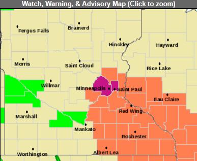
Excessive Heat Warning. The NWS has issued warnings for the immediate Twin Cities area (Hennepin and Ramsey counties). All that asphalt and concrete will create afternoon temperatures at least 5 degrees warmer than the suburbs. A Heat Advisory is posted for all of southeastern Minnesota and southwestern Wisconsin.
URGENT - WEATHER MESSAGE
NATIONAL WEATHER SERVICE TWIN CITIES/CHANHASSEN MN
821 PM CDT MON JUN 6 2011
HOT AND HUMID CONDITIONS THROUGH TUESDAY...
AN EXCESSIVE HEAT WARNING REMAINS IN EFFECT FOR HENNEPIN AND RAMSEY COUNTIES UNTIL 7 AM ON WEDNESDAY...AND A HEAT ADVISORY REMAINS IN EFFECT FOR MUCH OF SOUTH CENTRAL MINNESOTA AND WEST CENTRAL WISCONSIN FROM NOON TO 8 PM TUESDAY. HOT AND HUMID CONDITIONS WILL PREVAIL OVER THE AREA TONIGHT THROUGH TUESDAY NIGHT. OVERNIGHT LOWS WILL ONLY DROP TO THE LOW TO MIDDLE 70S...AND THE HEAT WILL RETURN TUESDAY AFTERNOON WITH HIGH TEMPERATURES CLIMBING TO THE MIDDLE 90S. HEAT INDEX VALUES WILL MEET OR EXCEED 100 DEGREES FOR A FEW HOURS.
HENNEPIN-RAMSEY-
INCLUDING THE CITIES OF...MINNEAPOLIS...ST. PAUL
821 PM CDT MON JUN 6 2011
EXCESSIVE HEAT WARNING REMAINS IN EFFECT UNTIL 7 AM CDT WEDNESDAY...
AN EXCESSIVE HEAT WARNING REMAINS IN EFFECT UNTIL 7 AM CDT WEDNESDAY.
* TEMPERATURE...OVERNIGHT LOWS WILL ONLY FALL IN THE MID 70S...
FOLLOWED BY HIGHS IN THE MIDDLE 90S TUESDAY AFTERNOON. HEAT
INDEX VALUES ON TUESDAY WILL CLIMB TO AROUND 100 DEGREES.
* IMPACTS...THESE HOT AND HUMID CONDITIONS WILL LEAD TO A
HEIGHTENED RISK OF HEAT RELATED STRESS AND ILLNESSES. THIS
WILL BE ESPECIALLY TRUE FOR THE CENTRAL URBANIZED AREAS OF THE
TWIN CITIES METRO.
PRECAUTIONARY/PREPAREDNESS ACTIONS...
AN EXCESSIVE HEAT WARNING MEANS THAT A PROLONGED PERIOD OF DANGEROUSLY HOT TEMPERATURES WILL OCCUR. THE COMBINATION OF HOT TEMPERATURES AND HIGH HUMIDITY WILL COMBINE TO CREATE A DANGEROUS SITUATION IN WHICH HEAT ILLNESSES ARE LIKELY. DRINK PLENTY OF FLUIDS...STAY IN AN AIR-CONDITIONED ROOM...STAY OUT OF THE SUN...
AND CHECK UP ON RELATIVES AND NEIGHBORS.
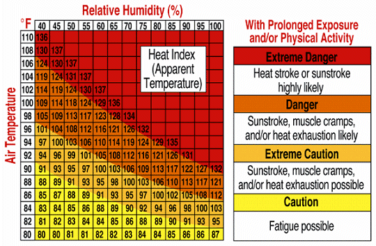
Heat Index. When dew points rise into the 70s and there is SO much water in the air, your body can't cool itself naturally by evaporating sweat off your skin. It's easy to overheat. This afternoon, with air temperatures in the mid to upper 90s, and a relative humidity in the 40-50% range, it will FEEL like 100-110 F.
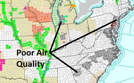
Air Quality Alerts. Stagnant, polluted air is a problem from Grand Rapids, Michigan and Indianapolis to Atlanta, Raleigh, Washington D.C. and New York City.
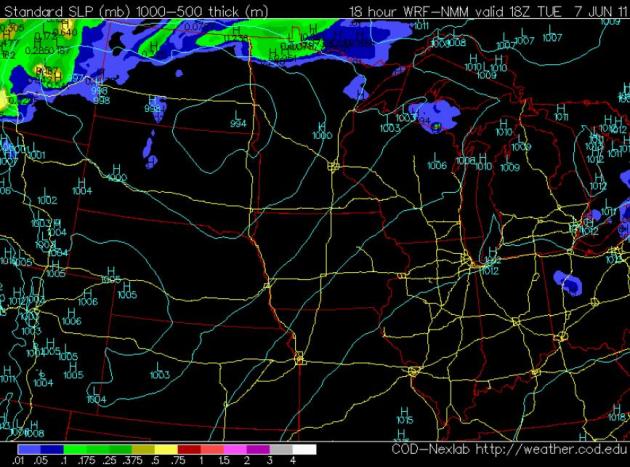
"Hot Zone". By 1 pm today the NAM model shows an area of low pressure over northeastern South Dakota, a strong south wind pumping tropical air into Minnesota, storms limited to far northern Minnesota, along the warm frontal boundary.
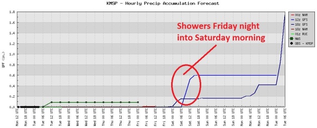
Dry Into Friday Morning? The NAM prints out a few hundredths of an inch of light showers late Thursday, but the bulk of the rain probably won't arrive until late Friday, Friday night and Saturday morning. Sunday still looks like the sunner, warmer day next weekend.
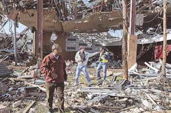
Photo Credit: "Partha Sarkar (left) and Bill Gallus, both Iowa State University professors, and graduate student Chris Karstens last week inspect destruction in the auditorium at Joplin High School. The team is compiling data and images to be studied at Iowa State."

Weather Videos:
Chile volcano:
http://www.youtube.com/watch?v=oFGjSpZNHNs
http://www.youtube.com/watch?v=ib2wk2CUeHU
AZ wildfire:
http://www.youtube.com/watch?v=OsY1stpHB0U
Smoke in NM:
http://www.youtube.com/watch?v=ZMgsnHnQYwA
http://www.youtube.com/watch?v=qmxz85_xp34
Smoke on the water:
http://www.youtube.com/watch?v=6MSyFA84u48
MO river flooding in MO:
http://www.youtube.com/watch?v=36LLS2UsvzQ&hd=1
MO river flooding in ND:
http://www.youtube.com/watch?v=Tgflgd9OucU&hd=1
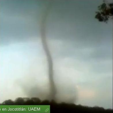
Killer Tornado In Mexico. Yes, another instance of (large/violent) tornadoes in unusual places. From the "Mad Weather" blog: "A rare tornado occurred on May 30th at Jocotitlan, Mexico (see map above), which is just north of Mexico City. The photo above is snipped from from a video that is online. The tornado caused significant damage and resulted in two deaths."
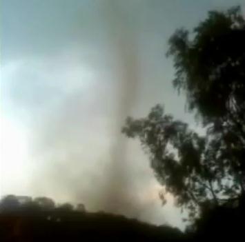
Mexican Tornado. Here is YouTube footage of the twister responsible for fatalities in central Mexico.
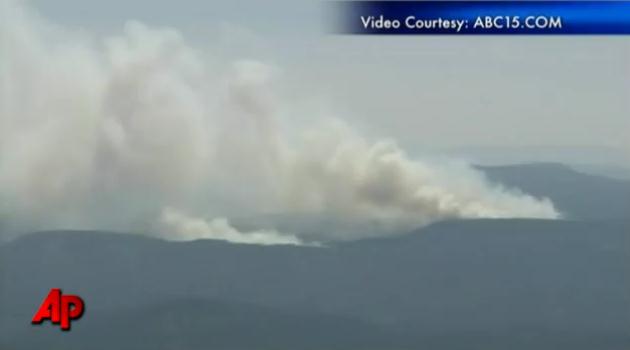
Arizona Wildfire Triggers New Evacuation Orders. YouTube and AP have the latest: "One of the biggest wildfires ever in Arizona grew even larger Sunday and authorities ordered more people in the area to abandon their homes as the 287-square-mile blaze burned toward more buildings. (June 6)"

Pokin Around: I'm Tired Of The High-Tech Wizardry Of TV Weather. Steve Pokin from the St. Louis Suburban Journals has had enough of all the flashy maps and Doppler-speak. Here is his eloquent appeal for sanity. Time to go back to an era of magic markers? "Follow the swirling arrows, the crisscross of giant L's and H's, the flashing lights, the lava-lamp colors that bulge across the Midwest and the advancing blue and red arcs. On any night, watch the TV weather graphics and you'd conclude one of two things.
1. The Earth's molten core will rise up tomorrow and cover Warren County.
2. You've inadvertently switched to the History Channel and what you're actually watching is a re-enactment of the battle of Gettysburg.
Me: "Look at how fast that low pressure front is moving into St. Louis!" My wife: "That's Pickett's charge." Enough, already, with the weather graphics! Scale back. You don't have to use all your high-tech toys. With all these neon, pulsing graphics, I'm sure, somebody, somewhere, is being induced into a seizure. A good attorney should be able to find this poor soul, this victim of Isobar Gone Too Far. I'm most familiar with the weather forecast of KMOV Channel 4. I'm the Journal staffer responsible for checking to see if Channel 4 — home of the Super Predictor! — has any St. Charles County news we need to chase."

Weiner-Gate And The New Media. In a world of me-too stories, this one really sticks out. CNBC.com tells you why you may want to think twice about hitting the "SEND" command: "No story exemplifies the dominance of new media in our cultural conversation more than the saga of Rep. Anthony Weiner. He sent pictures over Twitpic. He texted over his BlackBerry. He was outed by a blog. Rep. Weiner told journalists Monday that he used "Twitter, Facebook and occasionally the phone" in talking with women "I have met online." Notice he only used the phone "occasionally." Twitter, Facebook ... he used those more than occasionally. Back in the olden days of Bill Clinton and John Edwards, you had to meet a woman in person to get in trouble. If you did err, it was considered outside the mainstream to be busted by The National Enquirer. That is so ... two years ago. Now you can get in trouble virtually, and your sins can be revealed by anyone with a cellphone. The mainstream media is almost always a step behind. The fallout may be different now as well. Is Rep. Weiner ruined? "If he'd had an affair, he'd probably survive it," one person told me, "but this is just stupid." Stupid, yes, but Weiner is not resigning. For one thing, he says there was no affair. "I have never met any of these women or had physical relationships at any time."

Plains Milky Way. Here's a great timelapse of the Milky Way galaxy from Talking Science: "For this amazing video of the Milky Way traversing the South Dakota sky, photographer Randy Halverson shot hundreds of photographs of the night sky using a robotic camera rig. Each second of the video spans about 14 minutes of actual time. In an interview with Wired, Halverson explains what draws him to astrophotography: “It takes a lot of trial and error to get right, but it’s worth it,” he said. “It shows motion into the stars you don’t normally notice. When you look up at them, you often don’t realize how much they’re moving.”
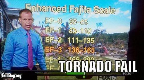
Sudden Urge For Mexican Food. O.K. Anyone can make a typo in the heat of battle - I feel bad for this guy. It's "Fujita", not "Fajita". One little letter goes a long way. Thanks to failblog.org for bringing this to our attention.
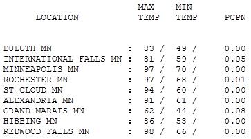
Record-Setting Heat. At 97 the Twin Cities broke a record on Monday (the old record was 95 in 1987). HIghs ranged from 62 at Grand Marais (summer nowhere in sight) to 94 at St. Cloud, 97 at Rochester and a blazing 98 at Redwood Falls. Today may be a couple degrees hotter.

Paul's SC Times Outlook for St. Cloud and all of central Minnesota:
TODAY: Excessive Heat Warning. Hot sun, potentially dangerous levels of heat & humidity. T-storms up north. Winds: S 15-30. High: 95 (feels like 105 by mid afternoon).
TUESDAY NIGHT: T-storms up north - probably dry in the metro area. Low: 71
WEDNESDAY: Partly sunny, cooler, much less humid. Low: 68. High: 79
THURSDAY: Mix of clouds & sun, comfortably cool. Low: 49. High: 66
FRIDAY: Clouds increase. PM showers, storms. Low: 52. High: 68
SATURDAY: Damp start, slow PM clearing. Low: 55. High: 72
SUNDAY: More sun, nicer day of the weekend? Low: 58. High: 79
MONDAY: Few showers, T-storms. Low: 60. High: near 80

Hot Front!
Welcome to Dubai (with lakes). A few weeks ago we were all shivering, roaming the streets in jackets, shaking our fists at a March-like sky. Summer came reluctantly, but now we got what we wished for, and then some.
An Excessive Heat Warning will probably be extended today; the combination of mid 90s and dew points in the 70s will make it FEEL like 105 by mid afternoon.
Here's the problem: when there's this much water in the air your body can't cool itself naturally via perspiration. Evaporation of sweat off your skin has a cooling effect (that's why you feel chilled stepping out of the shower). But with jungle-like humidity levels your body can easily overheat. Nausea, dizziness, cool, clammy skin are symptoms of heat exhaustion. Shallow breathing, rapid heartbeat and disorientation are symptoms of heat stroke, which can be fatal if not treated immediately. Slow down, take it easy out there - relief is 24 hours away.
A few storms over northern Minnesota may turn severe today, the cool front sailing through the metro area dry. 70s by Wednesday, 60s on Thursday; we'll all be breathing easier. Rain Friday night gives way to slow Saturday clearing; another fine Sunday on tap!
Climate Change Picks Up Faster With Carbon Emissions. 2010 set a record for the most CO2 and other greenhouse gases being released into the atmosphere. USA Today has the story:
"Carbon is now being released into the atmosphere 10 times faster than during a period of high temperatures 55.9 million years ago, and ecosystems may not be able to adapt quickly enough, an international team of geologists reports. The scientists used a computer model to calculate emission rates based on rock cores discovered in Spitsbergen, Norway, from the Paleocene-Eocene Thermal Maximum (PETM), an era when global temperatures had also spiked. "Rather than the 20,000 years of the PETM which is long enough for ecological systems to adapt, carbon is now being released into the atmosphere at a rate 10 times faster," Lee R. Kump, professor of geosciences at Penn State University said in announcing the findings, published in the current issue of Nature Geoscience. "It is possible that this is faster than ecosystems can adapt."

Climate Change Skeptics Endangered. Austalia's Gold Coast Mail has the story: "CLIMATE change sceptics are an endangered species in Australia, a national survey shows. The survey of almost 3100 Australians found 74 per cent believe the world's climate is changing. When asked a different question about the causes of climate change, which removed the reference to personal beliefs, 90 per cent of respondents said human activity was a factor. Just five per cent said climate change was entirely caused by natural processes. Overall, less than six per cent of respondents could reasonably be classified as true climate change sceptics, the study by Griffith University researchers found. "It's clear that people want the government to do something about climate change and they also feel they have a personal responsibility to act," environmental and social psychologist Professor Joseph Reser told AAP. The survey was carried out in June and July last year, with the results released on Friday. Prof Reser said the survey was one of the few in-depth studies that really drilled down into public perceptions and understandings about climate change."
No comments:
Post a Comment