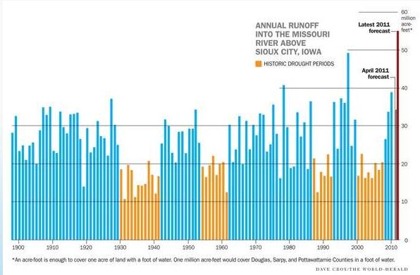
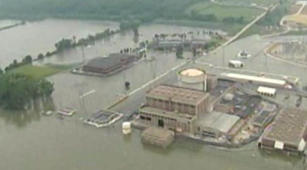
"...In more than a century of record-keeping, the nation's longest river has never coped with more water. Floodwaters are breaching levees, triggering evacuations, closing highways, swamping thousands of acres of farmland, destroying homes and lapping against hurriedly reinforced floodwalls protecting cities, airports and power plants, including two in Nebraska that produce nuclear power." - update on Missouri River flooding from omaha.com (below).
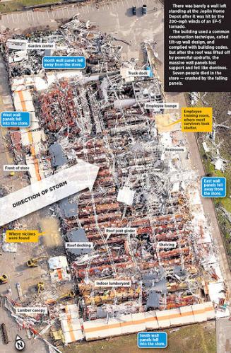
"...Most building codes in “tornado alley” require that commercial structures withstand only 90-mph winds, slower than many major league pitchers’ fastballs." - article on building codes in the aftermath of the Joplin tornado (below).
"...Surprising new evidence suggests the pace of the earth's most abrupt prehistoric warm-up paled in comparison to what we face today. The episode has lessons for our future." - article on the extreme pace of planetary warming below.
Blistering Heat Grips Texas:
116 F: Childress, Texas on Sunday, hotter than any time on record, including the Dust Bowl years of the 1930s.
113 F: Borger, Texas yesterday - hottest on record.
111 F: Amarillo, Texas on Sunday; hottest temperature ever recorded.
.33" rain predicted for St. Cloud today as a slow-moving cool front pushes eastward across the state.
*
Mea Culpa. No, the weekend wasn't quite as nice as we had hoped (although Saturday was MUCH better in the St. Cloud area than it was in the Twin Cities - trust me). Meteorologists are human (believe it or not), just like everyone else. We too HOPE and PRAY for nice weather on the weekends, for a variety of reasons. We like sunshine too. We also know that when the weather turns foul (even if it's in the forecast) we're going to get an earful. For some reason this year it doesn't take much of a nudge for the atmosphere to whip up clouds and showers. An "upper air disturbance" sparked a smear of clouds and a few spotty showers Saturday. Yesterday turned out cloudier than expected (with a few hours of sunshine) - still a stretch calling this "partly sunny", I realize. The one consolation: the vast majority of the weekend was dry, warm enough yesterday for the lake and pool. That said, I wish Gov. Dayton would decree that weekends could fall on Tuesdays and Wednesdays. Just this summer. Just this once. Please.
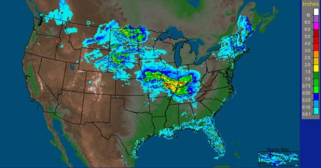
. 1-2" rains soaked parts of the Dakotas (not what residents of Minot, North Dakota were hoping for) on Sunday - as much as 2-4" of rain inundated a swath of the nation's midsection from southern Iowa to Evansville, Indiana. St. Louis picked up over 4" of rain, a month's worth in 24 hours. Data courtesy of
NOAA.
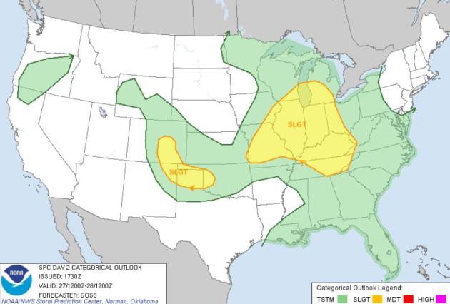
Monday Severe Risk. The greatest threat of (isolated) severe storms today extends from Milwaukee and Chicago to St. Louis and Louisville and Indianapolis, storms flaring up ahead of a weak cool frontal boundary. More details from
SPC here.
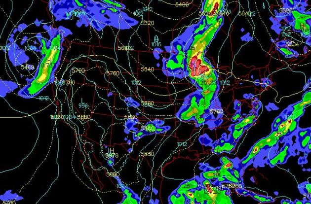
Shades of Early May. The calendar says late June, but as far as the atmosphere is concerned it's still early May, the core of the jet stream still unusually far south for late June. The heaviest rains (shaded red) will fall over Michigan, an eastbound cool front sparking strong/severe storms southward through Chicago and Indianapolis to St. Louis. A few scattered storms are likely over the southeastern USA, a cooling trend over the Upper Midwest, hot/dry weather lingering over Texas - while a Pacific storm pushes showers into Portland and Seattle by Monday night.
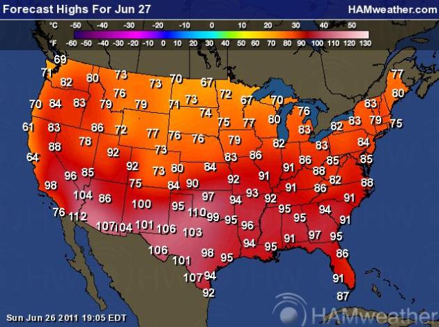
Monday Highs. A 40-45 degree north-south temperature contrast across the Lower 48 states? Pretty unusual for late June. Highs later today range from a brisk 67 at Duluth to 110 at Amarillo, Texas and 112 at Phoenix. Map courtesy of
Ham Weather, a division of WeatherNation.
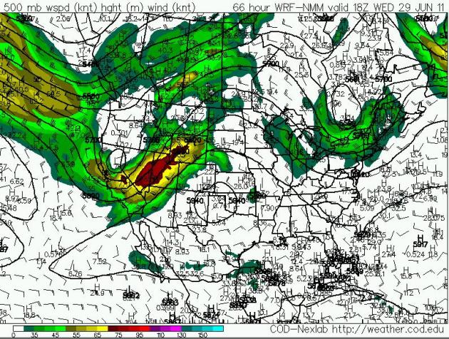
Midweek Winds. The NAM/WRF forecast for Wednesday (1 pm) shows a deep trough of low pressure over the western USA (showers pushing across California into the Intermountain West), while a second trough sparks showery rains and a significant cooling trend over New England by midweek. A large ridge of high pressure (centered over Texas) will build over the Plains later this week, meaning a significant warming trend from Kansas City to Des Moines and the Twin Cities by Thursday & Friday.
Flooding: The Worst Is Yet To Come. Residents of Omaha are bracing for a surge of water coming down the Missouri River, as reported by
omaha.com: "
Imagine roughly 55 million acres — the entire surface of Nebraska and southwest Iowa — covered in a foot of water. Now imagine trying to funnel all that water down a drainage canal surrounded by airports and homes, businesses and farms. You can begin to grasp the unprecedented, slow-developing danger facing folks from Montana to Missouri from the Great Flood of 2011. In more than a century of record-keeping, the nation's longest river has never coped with more water. Floodwaters are breaching levees, triggering evacuations, closing highways, swamping thousands of acres of farmland, destroying homes and lapping against hurriedly reinforced floodwalls protecting cities, airports and power plants, including two in Nebraska that produce nuclear power. The damage bill will tally in the hundreds of millions. As bad as it's been, the hardest parts are still ahead, according to the U.S. Army Corps of Engineers, the river system's managers. “It's going to be a devastating season in terms of how the levees do,” said Brig. Gen. John McMahon, commander of the corps' Northwestern Division. “There's going to be a lot of pain and suffering.” Frustration and questions along the river are rising, too. Elected officials, including the governors of Nebraska and Iowa, have criticized or called for investigations of the management of the Missouri by the corps."
Concern At Nebraska Reactors As Floodwaters Rise. Not a good situation along the Missouri River. What's ironic is that nuclear reactors rely on rivers (or oceans) for a fresh supply of cool water to cool the reactors - but too much water can be a safety hazard, as reported by the
New York Times: "
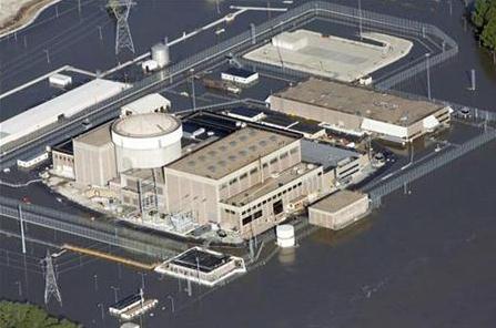
BROWNVILLE, Neb. — Like inhabitants of a city preparing for a siege, operators of the nuclear reactor here have spent days working to defend it against the swollen Missouri River at its doorstep. On Sunday, eight days after the river rose high enough to require the operators to declare a low-level emergency, a swarm of plant officials got to show off their preparations to the chairman of the Nuclear Regulatory Commission. The reactor, Cooper Station, is one of two nuclear plants on the Missouri River that are threatened by flooding. The second reactor, Fort Calhoun, 85 miles north, came under increased pressure for a brief period on Sunday. Before dawn, a piece of heavy equipment nicked an eight-foot-high, 2,000-foot-long temporary rubber berm, and it deflated. Water also began to approach electrical equipment, which prompted operators to cut themselves off from the grid and start up diesel generators. Both nuclear plants appear well prepared to weather the flooding, their operators and federal government regulators say. Fort Calhoun was shut down in April for refueling and stayed closed because of predictions of flooding. Plant officials say the facility is designed to remain secure at a river level of up to 1,014 feet above sea level. The water level stabilized at 1,006.5 feet on Sunday, according to the Omaha Public Power District, the operator of the Fort Calhoun plant."
Flood Berm Collapsed At Nebraska Nuclear Plant. KMTV.com and AP have a late update: "
FORT CALHOUN, Neb. (AP) - A berm holding back floodwater at the Fort Calhoun Nuclear Station has collapsed. The U.S. Nuclear Regulatory Commission says it's monitoring the Missouri River flooding at the plant, which has been shut down since early April for refueling. The 2,000-foot berm collapsed about 1:30 a.m. Sunday, allowing the swollen river to surround two buildings at the plant. The NRC says those buildings are designed to handle flooding up to 1014 feet above sea level. The river is at 1006.3 feet and isn't forecast to exceed 1008 feet."
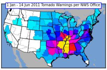 Tornado Count: 2011.
 Here's an update from the
Iowa Environmental Mesonet at Iowa State: "
The featured map presents the number of tornado warnings issued by each NWS forecast office so far this year. The largest value is 179 by the Memphis office. This year has seen more than its fair share of tornadoes. The largest numbers of warnings are shifted a bit east of the traditionally known tornado alley. Iowa has seen its share of severe weather recently, but most of it has been hail and wind."
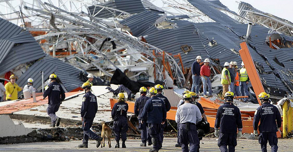
Experts Challenge Building Design Codes After Joplin Tornado. When a tornado is approaching you don't want to be in a mobile home, an auditorium or large room, or a "big-box" store either. The aftermath of Joplin's EF-5 is prompting a harsh look at building codes, and how companies can do a better job keeping staff (and guests) safe during severe winds. The
Kansas City Star has the story: "
JOPLIN, Mo. | As the monster tornado bore down on them, Rusty Howard and his two small children sought refuge in a Home Depot store. But instead the young father, the children and four other people died when the roof came off and the walls came down, crushing them beneath a 100,000-pound concrete panel. Within seconds the entire structure collapsed in a heap of concrete slabs, metal trusses and roofing. At least 28 other people survived, huddled in an un-reinforced training room in the back of the building. Rescue workers found Howard with an arm wrapped around each child. There aren’t many safe havens in such ferocious, 200-mph winds. Most building codes in “tornado alley” require that commercial structures withstand only 90-mph winds, slower than many major league pitchers’ fastballs. But while all big-box stores are vulnerable to high winds, the Joplin Home Depot — even though it met local building codes — was especially at risk, according to engineers who study the destruction that tornadoes leave behind. The Joplin Home Depot and many of the company’s other stores used a popular construction method called “tilt-up wall” that The Kansas City Star found can be deadly under certain conditions."
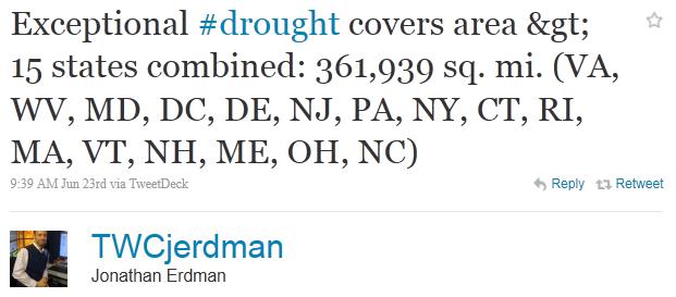
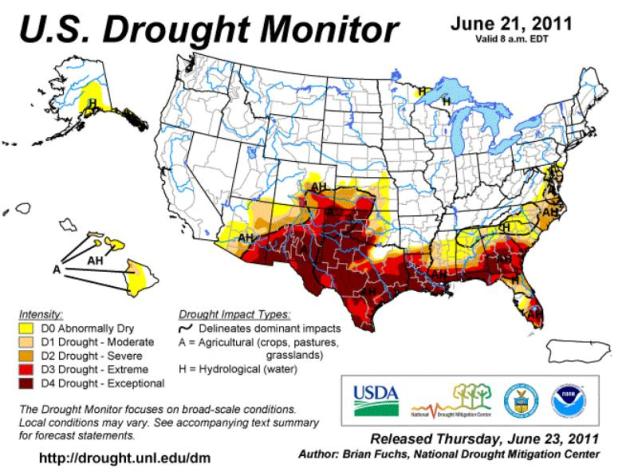
Latest Drought Monitor. According to NOAA 9.89% of the Lower 48 States is in an "exceptional drought". That's up from 7.54% of the USA just a week ago. Three months ago there were no reports of exceptional drought nationwide. The latest map is
here.
A Quarter BILLION Dollars Worth of Tree Damage In Alabama? The
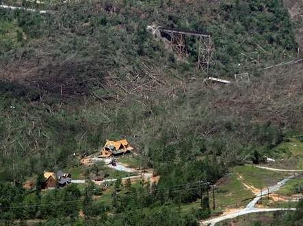
Tuscaloosa News has a story about the extent of damage to Alabama's forests - not as bad as Hurricane Ivan in 2004, but the damage toll is rising up into the hundreds of millions of dollars: "
April’s tornadoes will long be remembered for laying waste to lives and homes and buildings. Less noticed has been the destruction beyond neighborhoods and towns. The storms also sliced through miles of valuable timber, and those losses might not be fully realized for years. Alabama’s forest and timberland losses from the tornadoes that hit the state on April 15 and April 27 stand at more than a 204,000 acres valued at more than $266 million, according to a preliminary assessment by the Alabama Forestry Commission. And those figures could get higher. That’s because damaged and downed trees remain an immediate fuel for forest fires that could spread to healthy woodlands, especially during the current drought. Also, the longer damaged, dead and dying trees remain in woods, the more susceptible surrounding healthier trees become to insect infestation and disease, said Assistant State Forester Patrick Glass. Some of the worst timberland destruction occurred in West Alabama counties, with Tuscaloosa County sustaining the biggest losses in the state. More than 10,000 acres of forest land in the county were damaged, with 750,000 tons of timber valued at more than $25 million lost, according to the Forestry Commission survey Only Hurricane Ivan in 2004 was more devastating to the state’s forests than the April tornadoes.
Ivan caused about $475 million in damage, mostly in southern Alabama, while the tornadoes’ destruction was in central and northern Alabama."
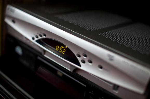
Atop TV Sets, A Power Drain That Runs Non-Stop. Yes, your cable or satellite box is an energy-pig, running 24/7, humming away in the background so there's no way you'll miss the latest edition of "The Biggest Loser". European cable systems have a "sleep" mode which can cut power consumption in half, even a "deep sleep" function that drops power usage by 95%. The
New York Times takes a closer look: "
Those little boxes that usher cable signals and digital recording capacity into televisions have become the single largest electricity drain in many American homes, with some typical home entertainment configurations eating more power than a new refrigerator and even some central air-conditioning systems. There are 160 million so-called set-top boxes in the United States, one for every two people, and that number is rising. Many homes now have one or more basic cable boxes as well as add-on DVRs, or digital video recorders, which use 40 percent more power than the set-top box. One high-definition DVR and one high-definition cable box use an average of 446 kilowatt hours a year, about 10 percent more than a 21-cubic-foot energy-efficient refrigerator, a recent study found. These set-top boxes are energy hogs mostly because their drives, tuners and other components are generally running full tilt, or nearly so, 24 hours a day, even when not in active use. The recent study, by the Natural Resources Defense Council, concluded that the boxes consumed $3 billion in electricity per year in the United States — and that 66 percent of that power is wasted when no one is watching and shows are not being recorded. That is more power than the state of Maryland uses over 12 months."
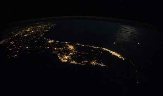
City Light From Space. Florida as you've never seen it, courtesy of
WJLA-TV in Washington D.C.: "
The land of alligators and meth-mouth, as seen from the space station in 2010. It's amazing so many lights are still on with all the copper-wire thieving going on down there."
"Compass of Pleasure".
Why Some Things Feel So Good. David Linden is a neuroscientists who has spent many years investigating pleasure and how the human brain is hard-wired to seek out pleasure. Here's a don't-miss read about his latest book from
NPR: "
Understanding the biology of the pleasure circuit helps us better understand and treat addiction, Linden says. It is important to realize that our pleasure circuits are the result of a combination of genetics, stress and life experience, beginning as early as the womb. "Any one of us could be an addict at any time," Linden says. "Addiction is not fundamentally a moral failing — it's not a disease of weak-willed losers. When you look at the biology, the only model of addiction that makes sense is a disease-based model, and the only attitude towards addicts that makes sense is one of compassion."
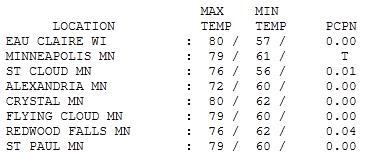
Could Have Been Worse. O.K. There wasn't as much sunshine as we had hoped (or I had predicted). Only a naive optimist would have called Sunday "partly sunny". But only a "trace" of rain fell in the Twin Cities,
.01" at St. Cloud, a whopping .04" rain as of 7 pm. Highs ranged from 72 at Alexandria to
76 at St. Cloud, 79 in the Twin Cities and 80 at Eau Claire.
 Paul's SC Times Outlook for St. Cloud and all of central Minnesota:
TODAY: Showers & T-storms possible early, PM clearing, windy and less humid. Winds: NW 10-20. High: 73
MONDAY NIGHT: Mostly clear and comfortable. Low: 53
TUESDAY: Bright sun, less wind - a beautiful summer day. High: 77
WEDNESDAY: High pressure lingers: blue sky. Low: 62. High: 81
THURSDAY: Hot & humid. Few T-storms possible. Low: 69. High: 87
FRIDAY: Front sails east. Sunny, less humid. Low: 68. High: 85
SATURDAY: Intervals of sun, a potentially lake-worthy day. Low: 67. High: 86
SUNDAY: Partly sunny, we may luck out. Low: 66. High: 84
4th of July: More clouds than sun, sticky - a few T-storms possible. Low: 6. High: 83
The Natives Are Restless
Here's how my weekend went. "Paul, why are you going out in public after blowing the forecast?" Excuse me? "The sun - where is it?" It's still there. "I can't SEE it at MY house, so you're WRONG!" People get indignant on summer weekends, when the sun doesn't shine as much as predicted. We're all sun-starved - after the snowiest winter in 25 years & a fickle spring. Don't mess with our weekends. We've earned a real summer. Please?
It's a tale of 2 nations: cool and soggy northern U.S. (with a risk of flooding). Drought, 110-degree heat and wildfires south. Sandwiched in-between: the "tornado zone." In 35 years predicting weather I've never seen anything like this in late June.
Having a graduation party or outdoor wedding now is risky behavior: June is the wettest, most severe month of the year in Minnesota.
Expect a slow commute into work; T-storms early - over 1" rain may leave standing water on some roads. After a stretch of stunning weather Tuesday & Wednesday T-storms return Thursday & Friday, highs near 90. High pressure may treat us to warm sun Saturday and Sunday (not as hot & sticky). T-storms could return by the 4th. The biggest weekend of summer - what can possibly go wrong?
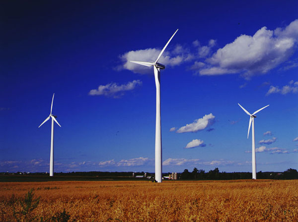
Wind Power: A Quiet Solution To Climate Change. Huffington Post has the story: "
We asked a tough question today: Is the fear and anxiety being spread about the sound of wind power justified? In an age when people fit subwoofers into their Honda civics, buy pickup trucks with 'tuned exhaust' noise and watch movies with ear crushing seven-speaker surround sound, one has to admit that our society isn't exactly aiming for quiet. Wind energy is now the fastest growing source of electricity worldwide. However, in some places where new windmills are being proposed, people are worried that they might be bothered by the sounds they make. In Ontario especially, folks are increasingly uneasy about how loud new windmills might be. For better or for worse, we have adapted to a life of auditory extremes. Weather you live in the country or in the city, chances are you have adapted to some kind of noise every day. Tires on a road, two-stroke whines from snowmobiles, motorcycles and jet-skis, diesel trucks, barking dogs, neighbours, airplanes, trains, music, construction, air conditioners, refrigerators, dishwashers, power tools -- the list of human created sounds is endless. It's a bit confusing then that one of quieter things we build -- windmills -- are said to be the subject of great handwringing and upset. When you step back and think about it, renewable energy is actually one of the more benign things in our society. It doesn't pollute our air, it doesn't poison our water, and compared to pretty much everything else, let's be honest -- it's not very loud either."
Whale's Odyssey Sheds Light On Climate Change. According to the article at
MSNBC.com the implications are enormous: "
When a 43-foot gray whale was spotted off the Israeli town of Herzliya last year, scientists came to a startling conclusion: it must have wandered across the normally icebound route above Canada, where warm weather had briefly opened a clear channel three years earlier. On a microscopic level, scientists also have found plankton in the North Atlantic where it had not existed for at least 800,000 years. The whale's odyssey and the surprising appearance of the plankton indicates a migration of species through the Northwest Passage, a worrying sign of how global warming is affecting animals and plants in the oceans as well as on land. "The implications are enormous. It's a threshold that has been crossed," said Philip C. Reid, of the Alister Hardy Foundation for Ocean Science in Plymouth, England. "It's an indication of the speed of change that is taking place in our world in the present day because of climate change, he said in a telephone interview Friday. Reid said the last time the world witnessed such a major incursion from the Pacific was 2 million years ago, which had "a huge impact on the North Atlantic," driving some species to extinction as the newcomers dominated the competition for food."
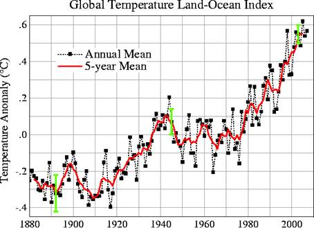
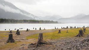 Don't Let Cool Spring Fool You - Experts Say Global Warming Is A Fact.
 The truth: we're in uncharted waters. We're seeing patterns we've never seen before - especially over the Arctic region. The northern states are still trending cooler than average, while the southern USA
broils and cooks in 100+ heat with wildfires and "exceptional drought". The huge contrasts in temperatures are whipping up unusually strong storms, capable of tornadoes, hail and flooding rains - compounding problems on the Missouri and Mississippi Rivers. The
Yakima Herald-Republic has the story: "
YAKIMA, Wash. -- With this year's heavy snowpack and a cool, wet spring that has delayed some harvests, it might be tempting to conclude that global warming isn't an issue in the Yakima Valley. But some of the state's most respected climate experts say the planet is still warming as carbon dioxide levels rise faster than ever, and the results have major implications for the region. Polar oceanographer Miles McPhee said unusual temperatures, plus the recent increase in tornadoes and storms nationally, indicate of a growing imbalance in the earth's weather patterns, caused by a rapid increase in carbon dioxide in the atmosphere and the oceans. "You can tie that to the energy we've been seeing in these storms," said McPhee, a Naches resident and graduate of Stanford University and the University of Washington. "The earth has to address this imbalance by moving heat around, and it's doing it in a way that might not be advantageous for us." It's true that temperatures in the Pacific Northwest have been cooler than average this year, but McPhee said temperatures in the Southwest have been higher than average. Although recent years have seen wider variations with hotter and colder temperatures and different levels of precipitation, experts say it's just a matter of time before the definite impacts of global warming overtake those trends."
The Last Time The Earth Got Hot. Doug Craig and
redding.com has a fascinating post about previous warming trends on Earth. He talks to an expert who claims the rate of warming today is unprecedented with anything geologists and climate scientists can document looking backward in time: "
Now while the rate of warming 56 million years ago was 0.025°C per century, current trends suggest a minimum rise of 1 to 4°C just this century. And while it took 20,000 years for the Earth to heat up by 5°C back then, current trends will see a rise of 2 to 10°C over the next 200 to 300 years.
Kump tells us that when you compare the present warming with the last one, "the climate shift currently under way is happening at breakneck speed."
In a matter of decades, deforestation and the cars and coal-fired power plants of the industrial revolution have increased CO2 by more than 30 percent, and we are now pumping nine petagrams (one petagram equals one billion tons) of carbon into the atmosphere each year."
That rate is expected to reach 25 billion tons a year until all fossil-fuel reserves are exhausted."
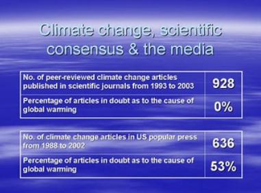
Science Groups In Agreement On Climate Change. From an Op-Ed at the
Birmingham News: "
As the world's largest general scientific society, the American Association for the Advancement of Science adopted an official statement on climate change in 2006: "The scientific evidence is clear; global climate change caused by human activity is occurring now, and is a growing threat to society....the pace of change and the evidence of harm have increased markedly over the last five years. The time to control greenhouse gas is now." Since 2001, 32 national science academies have come together to issue joint declarations confirming anthropogenic global warming and urging the nations of the world to reduce greenhouse gases. They include the national science academies of Australia, Belgium, Canada, China, France, Ireland, India, Japan, the Royal Swedish, the United Kingdom and the United States. The International Panel on Climate Change's position of January 2001 says: "An increasing body of observations gives a collective picture of a warming world and other changes in the climate system. There is new and stronger evidence that most of the warming observed over the last 50 years is attributable to human activities." No scientific body of national or international standing has maintained a dissenting opinion; the last was the American Association of Petroleum Geologists. The Australian Medical Association issued a statement saying climate change will impact our health in many ways, such as an increase in storms, floods, heat waves, fires, as well as an increase in malaria, dengue fever, Ross River virus and salmonellosis."
Brenda Blue
Birmingham









No comments:
Post a Comment