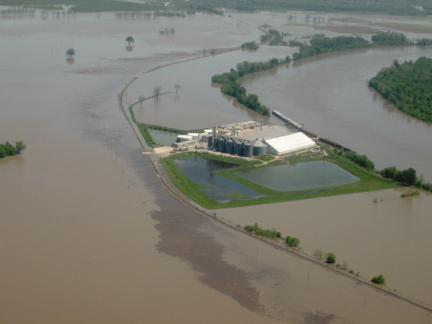
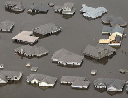
 "...Throughout the Missouri River Valley and other parts of the upper Midwest, there's simply no place left for any more water. That brings a new threat to the nation's water-logged midsection: more rain. In a region already struggling with historically high water, the return of heavy storms could intensify the flooding and turn a soggy summer into a tragic one for a dozen states that drain into the Missouri.
 " - article on massive, ongoing flood risk for the Missouri River below.
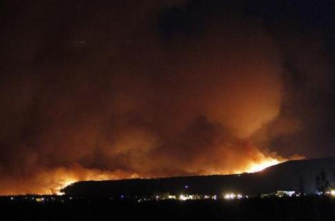
 "...A mandatory evacuation was ordered for the town of Los Alamos, which has a population of about 12,000. The speed at which the fire has grown surprised fire officials." - from a N.Y. Times article on the massive wildfire engulfing the nuclear-testing facility in New Mexico (details below).
 (Photo Credit: T. J. Shankland)
6th wettest June on record in Des Moines.
100 mph+ straight line winds near Fort Dodge, Iowa Sunday night
Record low relative humidity Monday in Las Vegas:
1%
Winter Weather Advisory:
above 8,000 feet in the Sierra Nevada mountain range of California. What month is this again?
$32 billion in estimated damage from floods, tornadoes and wildfires through June 25 (NCDC). This is the most damaging year for weather disasters since NCDC first started tracking weather-related damage in 1980.
$9.9 billion in weather-related damage reported for 2010, the entire year, across the USA.
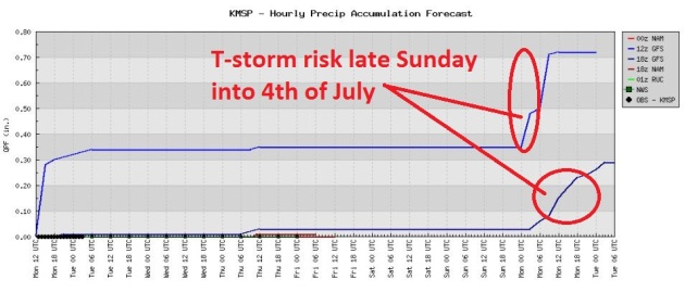 A Mostly-Dry Week
. So far this June 5.28" of rain has soaked the Twin Cities (1.38" more than average, to date). Models keep most of Minnesota dry into Saturday, although a few T-storms may flare up north/west of MSP late Thursday and early Friday. The chance of scattered T-storms will increase late Sunday and (naturally) on the 4th of July.
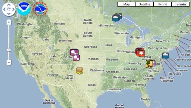 Monday Severe Storm Reports
. Large hail was reported on Denver's Front Range, a few funnel clouds in southern Ohio, wind damage in the Carolinas, and flash flooding over the Arrowhead of Minnesota. Click
here to see an interactive NWS map with all the details.
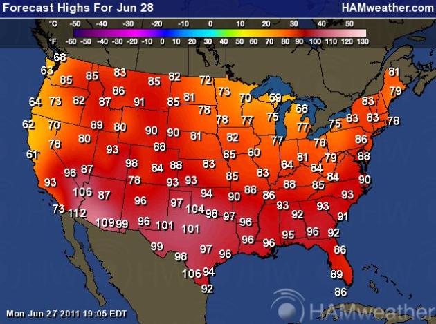 Tuesday Highs
. What a strange, baffling (and vaguely troubling) weather rut we're in. Highs today will range from 59 at Marquette, Michigan to 104 at Amarillo, Texas and 112 at Phoenix. Graphic courtesy of Ham Weather, a division of WeatherNation.
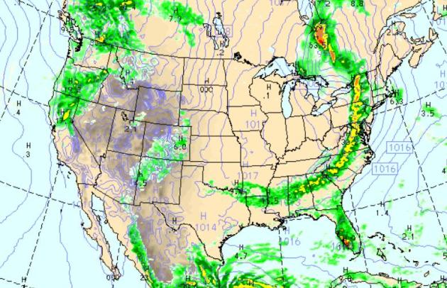 Tuesday Puddle-Potential
. An eastbound cool front will spark heavy T-storms from Syracuse and Washington D.C. to Atlanta and Huntsville, Alabama, a clearing/cooling trend for the Great Lakes and Ohio River Valley. Expect bright sun for the Upper Midwest and Great Plains, as well as the southwestern USA. A few pop-up T-storms sprout along Denver's Front Range, an eastbound front sparking showers from the San Francisco Bay Area north to Spokane, Washington. Florida will see numerous T-storms - good news, considering 87% of the Sunshine State is suffering through a drought.
 Tuesday Severe Threat
. A few isolated severe storms are possible east of Denver, and from Little Rock to Jackson, Mississippi and Huntsville, Alabama - a quieter day overall nationwide. Map courtesy of
SPC.
Souris River Crests In North Dakota, Surging Past 1881 Mark. The river crested 4 feet above the 1881 levels in Minot, inundating an estimated 4,000 homes.
USA Today has an update: "
North Dakota's Souris River crested this weekend but not before reaching historic levels, surging past a record set more than a century ago. The river peaked at slightly more than 1,561.7 feet above sea level late Saturday or early Sunday, 4 feet above the record level it reached in 1881. It had swamped an estimated 4,000 homes, although it is now expected to drop roughly 2 feet by midweek, said Jeff DeZellar, spokesman for the St. Paul District of the Army Corps of Engineers. "This is a new, historic record," said Bill Prokopyk, spokesman for the North Dakota National Guard. The river's peak was roughly 1½ feet lower than what had been predicted. The water's rapid rise had led to the evacuation of roughly 10,000 to 12,000 residents in the city of Minot, and the construction and reinforcement of earthen levees up and down the river. Although the Souris is expected to drop, officials said that it will be a while before the waters fully recede and months until the affected communities get back to normal. "The average flow in the river is around 100 cubic feet per second," DeZellar said. "That's almost no water, so it's going to take a long long time to get back to normal in terms of river flows and the recovery obviously is going to be months, for sure.''
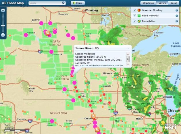
Flood Situational Awareness Map. The U.S. map of ongoing flooding (which integrates in social media into the information mix) was created by
ESRI. More details: "
This map allows you to view continuously updated U.S. flooding information. You can see observed flooding locations as well as precipitation information. The map also pulls in social media pertaining to flooding. In the Social Media box, you can change the search terms for YouTube, Twitter, and Flickr by hovering over the name of the feed, and then typing a new word into the displayed box."
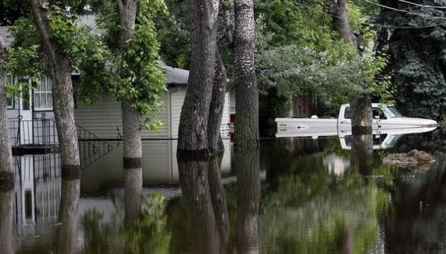
Rainy Weather Worsens Soggy River Basins. The
Argus-Leader has more on an unusually wet weather pattern in June, rainfall amounts running 2 to 3 times normal in many communities across the Dakotas - water now flowing downstream into the Missouri River Basin: "
MINOT, N.D. - The reservoirs are full. The dams are open wide. The rivers have already climbed well beyond their banks. Throughout the Missouri River Valley and other parts of the upper Midwest, there's simply no place left for any more water. That brings a new threat to the nation's water-logged midsection: more rain. In a region already struggling with historically high water, the return of heavy storms could intensify the flooding and turn a soggy summer into a tragic one for a dozen states that drain into the Missouri. "We know what's coming down the river, and what's going to continue to come down the river," said meteorologist Wes Browning of the National Weather Service office in St. Louis. "But what we don't know with any certitude, beyond five to seven days, is the amount of rainfall. That's really going to drive this flood." There should be sunny weather at least for the next few days, following rain across South Dakota on Sunday."
. Here's the latest from the
New York Times (a subscription may be required to read the full text of the NY Times Online - in my humble opinion it's worth every penny): "
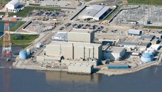
BROWNVILLE, Neb. — Like inhabitants of a city preparing for a siege, operators of the nuclear reactor here have spent days working to defend it against the swollen Missouri River at its doorstep. On Sunday, eight days after the river rose high enough to require the operators to declare a low-level emergency, a swarm of plant officials got to show off their preparations to the chairman of the Nuclear Regulatory Commission. The reactor, Cooper Station, is one of two nuclear plants on the Missouri River that are threatened by flooding. The second reactor, Fort Calhoun, 85 miles north, came under increased pressure for a brief period on Sunday. Before dawn, a piece of heavy equipment nicked an eight-foot-high, 2,000-foot-long temporary rubber berm, and it deflated. Water also began to approach electrical equipment, which prompted operators to cut themselves off from the grid and start up diesel generators. (It returned to grid power later Sunday.) Both nuclear plants appeared prepared to weather the flooding, their operators and federal government regulators said. Fort Calhoun was shut down in April for refueling and stayed closed because of predictions of flooding. Plant officials say the facility is designed to remain secure at a river level of up to 1,014 feet above sea level. The water level stabilized at 1,006.5 feet on Sunday, according to the Omaha Public Power District, the operator of the Fort Calhoun plant."
Nuclear Power Plants On Missouri River Are "Safe". That's according to Iowa Governor Terry Branstad. Here's the latest from the
Des Moines Register: "
Iowa Gov. Terry Branstad said today he remains confident of the safety of two nuclear generating plants located on the Nebraska border along the flood-swollen Missouri River. Aerial photos of the Fort Calhoun and Cooper nuclear plant have prompted international attention and worries of possible impending disasters of a scale similar to the tsunami-stricken Fukushima plant in Japan. However, operators of both plants and a federal agency that regulates them say the reactors are flood-proof, are in no danger of leaking, and extra precautions have been taken. Branstad told reporters today that Iowa officials have been monitoring the status of the two plants and he doesn’t believe the public should be worried. He also praised officials from Iowa’s public utilities for taking steps to prevent flooding at coal-fired electric plans on the Iowa side of the Missouri River. “The utility companies have done a great job of protecting those from flooding. We feel very confident there is no danger involved with that,” Branstad said."
PUBLIC INFORMATION STATEMENT
NATIONAL WEATHER SERVICE DES MOINES IA
1005 AM CDT MON JUN 27 2011
...2011 MOVES TO 6TH WETTEST JUNE ON RECORD...
THE DES MOINES AIRPORT HAS RECORDED 10.28 INCHES OF RAINFALL THUS
FAR THIS MONTH. THIS PLACES JUNE 2011 AS THE 6TH WETTEST JUNE ON
RECORD. RAIN CHANCES FOR THE REMAINDER OF THE MONTH WILL BE
MINIMAL. SO CHANCES OF MOVING UP THE LIST ARE UNLIKELY. THE 5TH
WETTEST JUNE ON RECORD OCCURED IN 1882 WITH 12.16 INCHES.
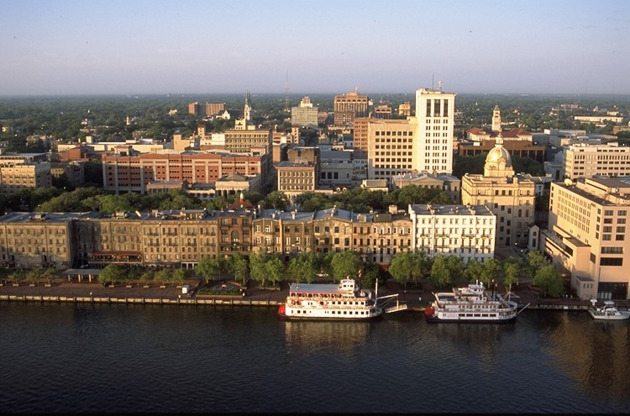 * According to the Southeast Regional Climate Center, Savannah, GA has had a high of 90° or higher for 38 consecutive days. The record for Savannah is 44 days. By all means, this record could be broken later this week.
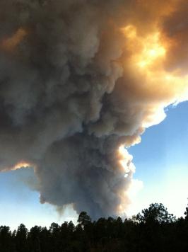
100 Evacuated As New Mexico Wildfire Threatens Los Alamos Lab
* According to the Southeast Regional Climate Center, Savannah, GA has had a high of 90° or higher for 38 consecutive days. The record for Savannah is 44 days. By all means, this record could be broken later this week.
100 Evacuated As New Mexico Wildfire Threatens Los Alamos Lab. Wildfires are partially under control in Arizona - but have now spread into New Mexico. Authorities believe there is no risk of radiation being released into the environment.
USA Today and AP have the latest: "
LOS ALAMOS, N.M. (AP) — Federal forest officials say a wind-driven wildfire has forced the evacuations of about 100 people in northern New Mexico and the closure of the Los Alamos National Laboratory. U.S. Forest Service officials said early Monday that the fire has burned at least six square miles and is threatening buildings, power lines and natural gas lines. They say it is about one mile southwest of the government laboratory. Lab officials has closed the facility and say all radioactive and hazardous materials were being protected. The site was founded during World War II to develop the world's first nuclear weapons. Gov. Susanna Martinez toured the lab's emergency operations center late Sunday. Los Alamos County authorities have issued voluntary evacuation orders for the towns of Los Alamos and White Rock. Residents from the rural towns of Cochiti Mesa and Las Conchas were evacuated after the fire started Sunday."
Wildfire Reaches U.S. Los Alamos Nuclear Facility:
another update from
Reuters:
* Los Alamos ensures reliability of US nuclear arms.
* Officials say facility is "very well protected" (Updates throughout).
A mandatory evacuation was ordered for the town of Los Alamos, which has a population of about 12,000. The speed at which the fire has grown surprised fire officials. The laboratory, which ensures the safety and reliability of the U.S. nuclear stockpile, is a national security research facility located in the Jemez mountains of northern New Mexico. It was set up in 1943 as part of the Manhattan Project to create the first atomic bomb and still maintains the nation's largest nuclear weapons arsenal. Firefighters were able to douse flames on a one-acre (0.4 hectare) "spot fire" just inside the southwestern boundary of the lab site, about 25 miles (40 km) outside Santa Fe, authorities said. Buildings still have not been touched by flames, and authorities said there was little threat to sensitive areas of the 28,000-acre complex (11,000 hectare)."
"SANTA FE, N.M., June 27 (Reuters) - A raging wildfire on Monday briefly entered the property of the preeminent U.S. nuclear facility, Los Alamos National Laboratory, a vast complex that houses research laboratories and a plutonium facility.
* CNET has more details on the fire at Los Alamos
here. The entire city of 12,000 was evacuated late Monday.
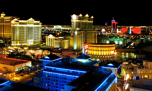 Record Low Relative Humidity At Las Vegas
. Just when you think you've seen it all: flooding, tornadoes, record heat, record drought, wildfires, now this: a report of the lowest relative humidity ever measured at Las Vegas: 1% Talk about lip chapping! Details from the local NWS office:
RECORD EVENT REPORT
NATIONAL WEATHER SERVICE LAS VEGAS NV
445 PM PDT MON JUN 2 2011
...ALL-TIME RECORD DEW POINT DEPRESSION SET AT LAS VEGAS TODAY...
AT 432 PM PDT TODAY THE DEW POINT DEPRESSION AT MCCARRAN
INTERNATIONAL AIRPORT IN LAS VEGAS REACHED 129 DEGREES. THE DEW
POINT DEPRESSION IS DEFINED AS THE DIFFERENCE BETWEEN THE AIR
TEMPERATURE AND THE DEW POINT TEMPERATURE. IN THE CASE OF TODAY THE
AIR TEMPERATURE WAS 107 DEGREES AT 432 PM AND THE DEW POINT
TEMPERATURE WAS -22 DEGREES. THIS MADE FOR A RELATIVE HUMIDITY OF 1
PERCENT AT THE TIME. THE PREVIOUS ALL-TIME RECORD DEW POINT
DEPRESSION FOR LAS VEGAS WAS 120 DEGREES SET ON JULY 2ND 2007.
THE ABOVE INFORMATION IS PRELIMINARY AND IS SUBJECT TO A FINAL
REVIEW BEFORE BEING CERTIFIED BY THE NATIONAL CLIMATIC DATA CENTER.
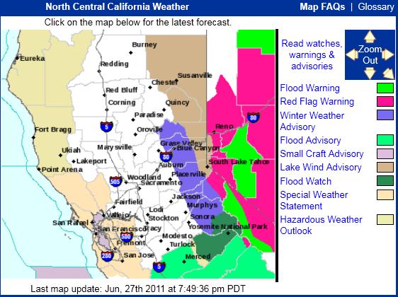 Late June Snowfall
. Meanwhile, unusually cool (snowy) weather is predicted for the higher elevations of California!
URGENT - WINTER WEATHER MESSAGE
NATIONAL WEATHER SERVICE SACRAMENTO CA
233 PM PDT MON JUN 27 2011
..UNSEASONABLY COOL AND SHOWERY WEATHER SYSTEM TUESDAY AND
WEDNESDAY.
.A VERY DYNAMIC AND COOL LOW PRESSURE SYSTEM CONTINUES TO APPROACH
NORTHERN CALIFORNIA FROM THE GULF OF ALASKA AND WILL MOVE OVER
THE SIERRA NEVADA TUESDAY AFTERNOON INTO WEDNESDAY. THIS SYSTEM IS
PROJECTED TO BRING WELL ABOVE NORMAL PRECIPITATION AMOUNTS FOR
THIS TIME OF YEAR ALONG WITH CHANCES OF THUNDERSTORMS.
...WINTER WEATHER ADVISORY IN EFFECT FROM 2 AM TO 2 PM PDT
WEDNESDAY ABOVE 7000 FEET...
THE NATIONAL WEATHER SERVICE IN SACRAMENTO HAS ISSUED A WINTER
WEATHER ADVISORY ABOVE 7000 FEET FOR SNOW AND BLOWING SNOW OVER
THE WEST SLOPE OF THE NORTHERN SIERRA NEVADA...WHICH IS IN EFFECT
FROM 2 AM TO 2 PM PDT WEDNESDAY.
 Lightning Strike Leaves Its Mark
. This is why you don't want to be on or near a golf course (or field, beach or body of water) during an electrical storm. The story from Bloomington, Illinois and
pantagram.com: "
Ironwood Golf Course superintendent Rob Hale looks at the Hole No. 9 green after it was hit by lightning during an early morning storm Monday, June 27, 2011, in Normal. The blast didn’t leave any damage on the green or strike the flagstick, but a lightning image usually seen in the sky was left as an imprint that stretches about 20 feet across on the front of the green. (The Pantagraph/Jim Benson)."
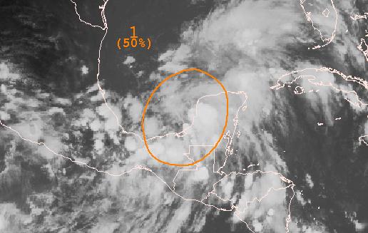
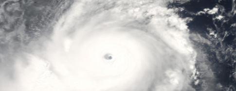
 Tropical Storm Arlene?
 According to
NHC there is a 50% probability that a tropical wave entering the Bay of Campeche, in the Gulf of Mexico, will develop enough of a circulation to create sustained 39 mph winds - strong enough to become the first official tropical storm of the season. Go ahead, flip a coin.
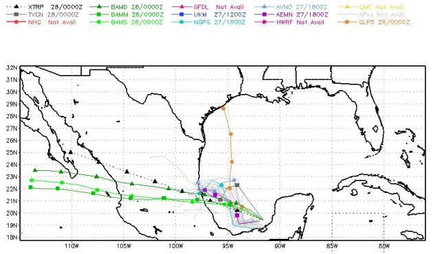 Projected Track
. Most of the
models push a developing tropical depression into interior Mexico; one model (GLP5) brings it due north toward Houston, which (compared to all the other solutions) seems unlikely.
"Historically Low" Global Cyclone Activity. An update from Dr. Ryan Maue at
Florida State: "During the past 6-years since Hurricane Katrina, global tropical cyclone frequency and energy have decreased dramatically, and are currently at near-historical record lows. According to a new peer-reviewed research paper accepted to be published, only 69 tropical storms were observed globally during 2010, the fewest in almost 40-years of reliable records. Furthermore, when each storm's intensity and duration were taken into account, the total global tropical cyclone accumulated energy (ACE) was found to have fallen by half to the lowest level since 1977. In his new paper, "Recent historically low global tropical cyclone activity", Dr. Ryan Maue, a meteorologist from Florida State University, examined the last 40-years of global hurricane records and found strikingly large variability in both tropical cyclone frequency and energy from year-to-year.
Since 2007, global tropical cyclone activity has decreased dramatically and has continued at near-historical low levels. Indeed, only 64 tropical cyclones were observed globally in the 12-months from June 2010 - May 2011, nearly 23-storms below average obliterating the previous record low set in 1977.
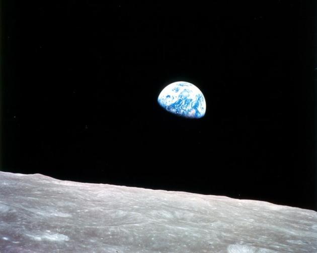
"UrtheCast" Video Platform Will Let Users View Earth (Live) From Space. This article at
gizmag.com caught my eye: a Canadian company is launching an (open-source) set of HD cameras on the ISS (International Space Station) that will eventually permit (live) streams of the Earth from space. Think of it as Google Earth on steroids - a live stream of the planet 200+ miles below, available by spring of 2012. Pretty cool. More details: "
Canadian-based company UrtheCast has announced a project intended to let a wider audience view the earth from space. A pair of cameras will be installed on the International Space Station, recording videos and imagery of the planet. The project's aim is to create an internet-based video streaming platform, thus allowing for online viewing of the footage being recorded in space. It's "the world's first and only near real time high definition video from space," according to UrtheCast's website. The International Space Station is a human-inhabited satellite, located at an altitude of around 350 km (217 miles) and traveling at a speed of 26,000 kph (16,155 mph). It orbits Earth 16 times a day. It was built as a joint effort of the Russian, European, Canadian, Japanese and US space agencies. UrtheCast (pronounced "EarthCast") is based around two cameras located on a steerable platform in the Russian module of the ISS. One of them is high definition, capturing videos at 3.25 fps and a resolution comparable to that of Google Earth. The other one is medium resolution, and will shoot still images taking in 45 km (28 mile)-wide stretches of the earth's surface. Viewers will supposedly be able "to see man-made objects and groups of people." Both cameras will be built by British Rutherford Appleton Laboratories (RAL). Videos and imagery collected by the cameras will be broadcast in an uncompressed format to a number of servers located around the planet, and then uploaded to the UrtheCast internet platform."
* From UrtheCast's
web site:
"UrtheCast is launching the world’s first ever high definition, streaming video platform of planet Earth. The camera will be installed on the outside of the International Space Station through a joint effort with the Russian Space Agency. The camera will provide a 40 km wide, high resolution, color image down to as close as 1.1 metres."
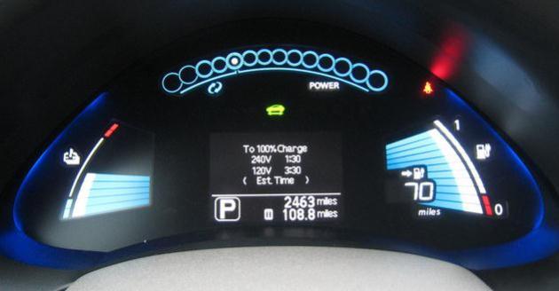 The Gadgetization of Cars Is Kind Of Ruining Them
. I have mixed feelings about this - increasingly younger car buyers are insisting that their vehicle remain "connected" on the highway - which could be a bad thing (if you're checking your FB posts instead of merging onto 494). More than ever we're dependent on software to power our vehicles. Which is great, when the computers actually work as advertised.
Gizmodo.com has more: "
The antique Thunderbird parked outside on my street right now will run, approximately, forever. Unlike my Honda Civic Hybrid, which will be in the scrapheap before my baby daughter hits college. Why? Because the gadgetization of cars is ruining them. As the L.A. Times reports: A key auto quality study found that new or redesigned 2011 models were less reliable than the previous year's line, much of it because of new high-tech navigation systems that didn't work properly. J.D. Power found that overall auto quality dropped in 2011, especially among American-made vehicles, largely due to the onboard electronics like in-dash touchscreen navigation systems that can befuddle and flummox users. Or the computerized transmission systems that are designed to give better fuel economy, but feel like hesitating ninnies to consumers. Back to my own Honda Civid Hybrid, it has never run as well after its most recent software update. Think of that. As a part of routine maintenance now, I have to update my vehicle's firmware."
TMZ: A Newsroom That Doesn't Need News. The
New York Times has an interesting story about TMZ.com, and our insatiable appetite for celebrity gossip and "news": "
LOS ANGELES It is 6:30 in the morning, and a stubborn mist is hanging low over the Hollywood Hills. This is when TMZ punches in and goes to work making a television show that is beamed out five nights a week to the rest of us, mining our culture’s need to know every single little thing about celebrities. Syndicated by Fox Broadcasting for the past three years, TMZ the show is recorded in the newsroom of TMZ the Web site, situated on Sunset Boulevard a block from the Chateau Marmont. It is an aggressive purveyor of celebrity news that has been known to uncover (or pay for) scoops that open the kimono on the world of Hollywood. But unlike Access Hollywood or Entertainment Tonight, TMZ lets viewers in on the joke. Five days a week, its reporters show up at work and the television lights come on above them and five cameras roam overhead as they discuss the “news” of the day. The newsroom is alive and buzzing about — well, let’s face it, nothing very important. No one pretends that they are covering the war in Afghanistan or the federal debt ceiling. They are covering show business, with an emphasis on the “show.”
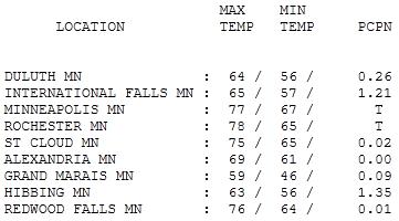 Monday Clearing Trend
. Violent storms rumbled south of Minnesota, across much of Iowa, Sunday night. Yesterday heavy showers and T-storms lingered over northern Minnesota - a few turned severe during the morning north/west of Duluth with hail (and some 1-1.5" rainfall amounts). Highs ranged from 63 at Hibbing to
75 at St. Cloud, 77 in the Twin Cities, a balmy 78 at Rochester.
 Paul's SC Times Outlook for St. Cloud and all of central Minnesota:
TODAY: Close to perfect. Blue sky. Winds: NW 10-15. High: 75
MONDAY NIGHT: Clear and comfortable. Low: 58
WEDNESDAY: Bright sun, warming up again. High: 81
THURSDAY: Sticky, isolated T-storm possible. Low: 67. High: 86
FRIDAY: Hot & stuffy, passing T-storm can't be ruled out. Low: 71. High: 88
SATURDAY: Nicest day of holiday weekend? Partly sunny, slightly cooler & less humid. Low: 63. High: near 80
SUNDAY: Some sun, few pop-up T-storms around town. Low: 61. High: 82
MONDAY: Warm, humid - stray T-storms. Much of the day should be dry (and sticky). Good day for the lake. Low: 63. High: 81

4th: "Partly-Thundery"
I have seen no scientific research proving that weekends attract clouds & storms. It sure seems that way, especially recently. It's perception: more of us are outdoors, more "weather-aware" on a Saturday than a Tuesday. A recent NASA study suggested that pollution from cities in Texas "seeded" clouds hundreds of miles downwind, increasing the risk of storms & hail, but there's no evidence that storms are magically attracted to weekends.
Holiday weekends may be a different story. I'm still reminded of a massive "bust" on the 4th of July, 1976 (!) I predicted sprinkles - it poured much of the day. Not good.
We've had 2 partly-lousy weekends in a row, but look at the bright side: no widespread severe outbreaks, limited flooding (in Minnesota) & reasonable humidity levels. Believe it or not we've been fairly lucky.
117 F at Childress, Texas (hotter than the Dust Bowl years), epic flooding on the Missouri River, $32 billion in damage in '11 (3 times what we saw all of last year).
Why can't weekends fall on Tuesdays and Wednesdays? Expect bright sun today and Wednesday - a return southerly flow around that fair-weather bubble of high pressure tugs the mercury close to 90 by Friday with a passing T-storm. Drier, cooler weather Saturday gives way to a few pop-up T-storms Sunday & the 4th; highs in the 80s. Not bad for the biggest holiday of summer.
Climate Change Heats Up In 2010, The Year Of Extreme Weather. Here's a good summary of a crazy-weather year, courtesy of
The Guardian (based largely on a significant post from Weather Underground's Jeff Masters): The year 2010 may have been the most extreme in terms of weather since the explosion of Indonesia's Mount Tambora in 1816, when much of the world experienced reduced daylight and no summer, says one of the world's most prominent meteorologists. A combination of abnormal climatic phenomena resulted in the year being the hottest, wettest, and in many cases also the driest and coldest in recorded history, says Jeff Masters, co-founder of climate tracking website
Weather Underground. According to Masters 2011 is already on track to be exceptional, with
a deepening drought in Texas – where 65% of the state is now in "exceptional
drought" conditions – and one of the
warmest springs experienced in 100 years taking place across much of Europe. It is also the most extreme tornado year recorded in the US, with Arctic sea ice already at its lowest ever for the time of year. US and UK government scientists declared in January that
2010 had tied with 2005 as the warmest year of the global surface temperature record – the 34th consecutive year with temperatures above the 20th-century average – but, says Masters, new data on other climatic phenomena suggest that extremes were widespread. Scientists recorded the second-worst year for coral bleaching (caused by raised sea temperatures), the lowest-ever volume of Arctic Sea ice, highly unusual monsoons in China and a series of abnormal storms across the US and elsewhere. Some of the phenomena have been linked to a strong
El Niño/La Niña episode, which follows unexplained temperature changes in the Pacific Ocean near the equator. Global tropical cyclone activity, however, was the lowest on record.
According to Masters, 19 countries – covering nearly 20% of the global land area – experienced their hottest recorded years in 2010. "Hot years tend to generate more wet and dry extremes than cold years. This occurs [because] there is more energy available to fuel the evaporation that drives heavy rains and snows, and to make droughts hotter and drier in places storms are avoiding," he says.
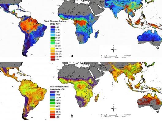
New NASA Map Shows Tropical Forest Carbon Storage. The story from NASA and
gizmag.com: "A NASA-led research team has created a new map using ground and satellite data that accurately quantifies the amount and location of carbon stored in Earth's tropical trees and forests. Based on data from the early 2000s, the map focuses on 2.5 million hectares of tropical forest in seventy-five countries. Data shows that tropical forests contain 247 billion tons of carbon, and of this carbon stock, almost half is held in Latin American forests. Almost the same carbon stock is stored in sub-Saharan Africa in its entirety, compared with 61 billion tons of carbon stored in Brazilian forests alone. "These patterns of carbon storage, which we really didn't know before, depend on climate, soil, topography and the history of human or natural disturbance of the forests," said leading researcher Sassan Saatchi of NASA's
Jet Propulsion Laboratory in Pasadena, California. "Areas often impacted by disturbance, human or natural, have lower carbon storage."
Up to a fifth of global carbon emissions are caused by deforestation and forest degradation, mainly in tropical areas. Carbon is stored in the wood and roots, but when trees are cut, burned or decompose, carbon is released into the atmosphere. Previous studies have only taken carbon measurements from individual countries or continents, and usually by calculating carbon from ground-based observations of tree heights. This is the first time researchers have achieved a pan-continental overview, across varying forest types and structures using the same methodology.
Obama's Inaction Disappoints Green Groups. The story from the
Washington Times: "
Former Vice President Al Gore’s criticism of President Obama on climate change and the administration’s failure to install solar panels as promised on the roof of the White House are shining a light on growing disillusionment with the president among environmental activists. While conservatives have expressed relief that Mr. Obama’s push for a carbon tax has stalled, green activists are showing increasing frustration with what they view as Mr. Obama’s timidity on the greenhouse-gas issue and other environmental concerns. “We all expected more from this president,” said Mike Tidwell, executive director of the Chesapeake Climate Action Network. “I am personally deeply disappointed. On the environment, he has led from the rear.” Mr. Gore’s claim that the president has “failed to use the bully pulpit to make the case for bold action on climate change” struck Frank O'Donnell, president of Clean Air Watch, as “on target.” Mr. O'Donnell said many environmentalists not affiliated with the Obama re-election campaign fault the president for failing to speak out more forcefully about climate change."
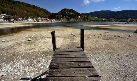
 Global Warming Decreasing Salt In Sea
.
iol.com's scitech desk has the story: "
London - Climate change will turn the Baltic Sea into an increasingly freshwater sea and devastate its marine life, according to scientists. A multinational study has found that an increase in precipitation in the region would lead the water in the Baltic to become less salty. Such a decrease in salinity would change the make-up of sea life, which is already suffering from over-fishing and harmful chemicals. Professor Chris Reid, of the Marine Institute, University of Plymouth, who was involved in the study, said: “Due to global warming, it is predicted there will be an increase in precipitation in the river basins that flow into the Baltic Sea. As a result - because it's an enclosed sea with a very narrow exit - the sea will become fresher. We predict this will happen over the next 100 years.” Transformations to the Baltic's ecosystem is among a number changes reported in the research project, led by Climate Change & European Marine Ecosystem Research (Clamer) which has collated more than 13 years' worth of reports, involving 17 marine institutes from 10 European countries. Another alarming discovery is the arrival of a new species of plankton in the north Atlantic from the Pacific. The microscopic species had disappeared from the region 800,000 years ago. As the melting Arctic icecap has opened the Northwest Passage, the plant has drifted back across the pole."


No comments:
Post a Comment