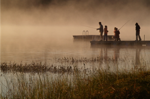
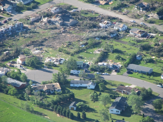
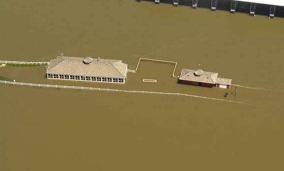
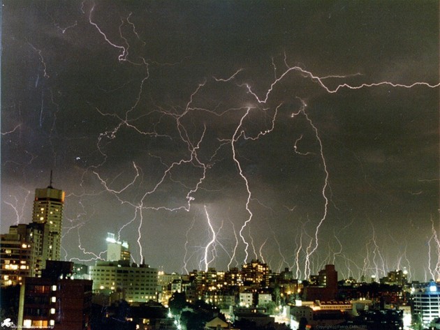
Wadena: One Year After The "Super-Outbreak." A year ago today a record 48 tornadoes touched down on Minnesota. That's roughly 2 year's worth of tornadoes forming in a single day. Hardest hit: Wadena, where an EF-4 "multi-vortex" tornado ripped right through the center of town. Details below.
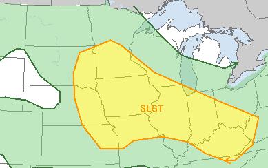
Slight Severe Storm Risk Today. Much of central and southern Minnesota is in a "slight risk", according to
SPC. Large hail, damaging straight-line winds, even an isolated tornado, can't be ruled out later today. Stay alert & connected to various media to get the latest information and possible warnings. More details below.
 Partly-Soggy
. A slow-moving frontal boundary will trigger the heaviest rains from the Brainerd Lakes into western Wisconsin much of Saturday and Sunday, with the best weather probably coming south/west of the Twin Cities, especially Saturday afternoon into Sunday. Check out the forecast for the latest details.
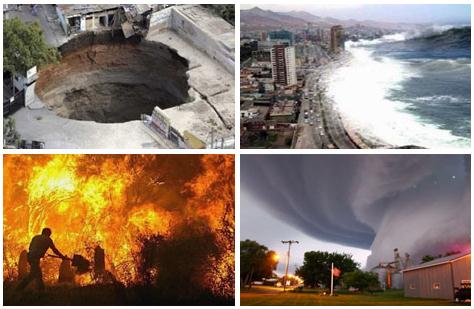
A Record Year For Weather Disasters? From a
New York Times article below: "The United States experienced some of the most extreme weather events in its history this spring, including deadly outbreaks of
tornadoes, near-record flooding, drought and wildfires.
Damages from these disasters have already passed $32 billion, and the hurricane season, which is just beginning, is projected to be above average, according to the National Oceanic and Atmospheric Administration.
Heatwave Continues To Sizzle The Southern Third of the USA.
AccuWeather has some amazing statistics on the heat & expanding drought below.
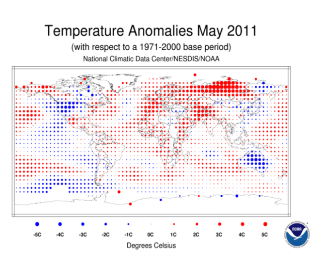
10th Warmest May On Record, Worldwide. Details from
NOAA below.
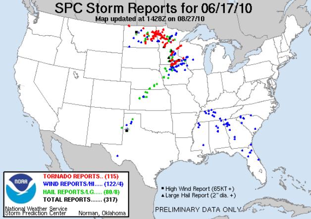
June 17, 2010 Super-Outbreak. Today marks the one year anniversary of the largest single-day outbreak of tornadoes in Minnesota history. More from the local Chanhassen office of the
National Weather Service: "On June 17, 2010, a significant tornado outbreak occurred across the Northern Plains. Beginning around 2 PM, thunderstorms moved across the region, producing 74 tornadoes. Of those tornadoes, 48 were in Minnesota, eclipsing the single-day tornado record. At the time that it occurred, it went down as the 17th largest tornado outbreak on record in the United States, and the 2nd largest in the summer months of June-August.
- 74 tornadoes across four states, including 48 in Minnesota. The number of Minnesota tornadoes was a new state record for tornadoes in a day.
- 16 strong to violent tornadoes (rated EF2 or higher), with 11 of those in Minnesota.
- The three EF4 tornadoes in Minnesota were the first in the state since the Granite Falls F4 of July 25, 2000.
- In terms of number of tornadoes, this outbreak was the 2nd largest on record in meteorological summer (June to August) at the time it occurred.
- NWS offices in the Northern Plains began to advertise the potential for severe weather 5 days in advance of this tornado outbreak in the Hazardous Weather Outlook products.
- The Storm Prediction Center issued Tornado Watches with a combined average lead time of 4 hours and 24 minutes for the tornadoes.
- 87 Tornado Warnings, 83 Severe Thunderstorm Warnings, and 3 Flash Flood Warnings were issued by National Weather Service offices in this region over approximately a 12 hour period. 279 follow-up statements to those warnings were also issued.
- The average lead time for Tornado Warnings during this outbreak was slightly over 19 minutes.
"In this case, on June 13th NWS offices in the Northern Plains began discussing the potential for strong and severe thunderstorms in their HWO products, 5 days in advance of the tornado outbreak."
- National Weather Service
Rotation Track Maps. More information on the June 17, 2010 super-outbreak of tornadoes from the local NWS in this 7-page
PDF: "
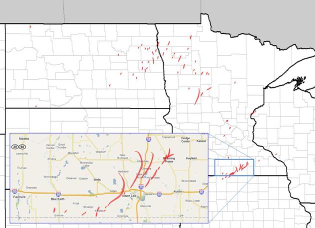
The National Severe Storms Laboratory produces several experimental products that prove useful when analyzing severe weather outbreaks. One of those is something called a “rotation track map”. This map is produced by running radar velocity data through a filter, and determining the shear at given instants in time across the entire United States radar network. These instantaneous values are then integrated across an entire time period. The resulting maps can reveal both tracks of rotating supercells, and fluctuations in intensity in those supercells. An example of one of those maps is shown (above), for June 17, 2010."
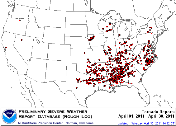
"Okla-Sota". Of the 115 tornadoes that formed on June 17, 2010, 48 of them touched down on Minnesota, including the EF-4 that hit Wadena. Map courtesy of SPC.
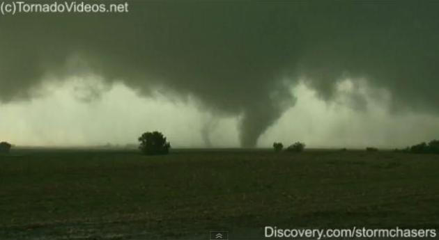
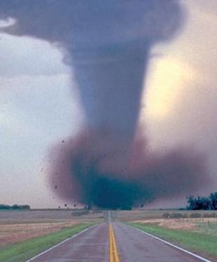
Wadena: A "Multi-Vortex" Tornado. The EF-4 that slammed into Wadena last year was no garden-variety twister. It was a massive "wedge" tornado, composed of several funnels all rotating around a common center. Something you'd expect to see in Kansas or Texas, not the North Woods of Minnesota. Here's more from Tornadovideos.net on the amazing tornado intercept that created this
YouTube clip: "
TornadoVideos.net Dominator intercepts violent wedge tornado southwest of Wadena, Minnesota, measuring incredible vertical winds with the radar, and launching parachute probes into the tornado with the cannon. We deployed in the strongest eastern side of the wedge, and the 150+ mph winds ripped off the room anemometer, sand-blasted the paint, and caused us to slide across the road with the hydraulics deployed. At least 4 parachute probes have been recovered so far, two of which were stuck in the top of large trees. Check out the full intercept on Discovery Channel's Storm Chasers this fall!!"
Wadena. One Year Later. Here's a
message from the mayor of Wadena, Wayne Wolden, heading up the clean-up effort in the town hit hardest by the June 17, 2010 outbreak:
"On behalf of the City of Wadena, I would like to extend my heartfelt concern to all citizens that were affected by the June 17 tornado. In the history of our great city, we have never experienced such devastation. We know that the landscape of our community will never be the same – but we also know that even in times of great despair there are many reasons to be thankful and to have hope. We are thankful that no lives were lost, for the outpouring of support from volunteers and disaster recovery resources, and for the thousands of donations of all kinds. We are hopeful that we will rise from the rubble and be an even better community and that because of this experience we will be stronger and more connected to one another. I would like to take this opportunity to thank everyone that has volunteered during the recovery. It’s hard to start and stop when naming people so I will simply say that you know who you are. You know if you have given of your time, talent, energy and resources – the City is indebted to you. Theodore Roosevelt once said, “What a man does for himself dies with him but what a man does for his community lives forever.” We know this is certainly the case for our fair city and it’s amazing to watch so many of you invest in us. We have so much to be proud of! We are making fantastic progress – you can see it everywhere you turn. The piles are coming and going, the streets are being cleaned, power is being restored, and Lastly, I would like to congratulate all of you for
 |
| WDC School |
finding it deep within yourselves to move forward. It would be easy to stop, stare and wonder where to begin, but that didn’t happen in Wadena. People just pitched in and soon recovery and progress were visible and that further energized the efforts.
I would like to encourage everyone to take this Sunday as a day of rest. You have earned it. We all need it. It’s time to take one day to slow down, reach out to your family and friends, and regroup. I believe this will be very important since we know the recovery will take some time to complete.
May your faith and energy be renewed.
Warm regards,
Mayor Wayne Wolden
Spring 2011 U.S. Climate Extremes.
NCDC has a summary of the crazy weather extremes the USA witnessed in April and May, including record flooding and record tornadoes: "
The spring (March-May) of 2011, particularly April, brought extreme weather and climate events to many parts of the United States. Tornadoes, flooding, drought, and wildfires ravaged many parts of the country during the period, and each of these extremes broke long-standing records and have been compared to the 'worst such cases' in history. While similar extremes have occurred throughout modern American history, never before have they occurred in a single month. According to the Storm Prediction Center (SPC), there were 875 preliminary tornado reports during April alone, and the confirmed number of tornadoes will approach the all-time monthly record of 542 tornadoes set in May 2003. Record rainfall along the Ohio River Valley, punctuated with snowmelt across the upper Midwest, caused record flooding along the mid and lower Mississippi River, with water levels surpassing the historic floods of 1927 and 1937. Above-normal precipitation and vegetative growth during 2010, followed by dry and windy conditions the first five months of 2011, created ideal wildfire conditions across the Southern Plains where millions of acres of land burned. According to the U.S. Drought Monitor (USDM), the same region experienced Extreme-to-Exceptional [D3-D4] drought following consecutive months that were record to near-record dry."
* Map above shows confirmed tornado touchdowns in April.
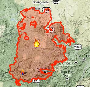
Strong Winds Threaten Containment Of Wallow Fire.
AccuWeather has the latest on the largest wildfire in Arizona history. The bottom line: Mother Nature is not cooperating: "
Higher winds today and Friday will complicate efforts to further contain the Wallow Fire, which has grown into the largest fire in Arizona history. Over 478,000 acres have been consumed by the man-made wildfire, which as of late Wednesday was 29 percent contained. Both low relative humidity and wind gusts exceeding 40 mph are forecast much of the time for the remainder of the week across eastern Arizona as a trough of low pressure digs into the Southwest. This could help spread the fire farther into eastern New Mexico, where hundreds of residents remain on pre-evacuation alert. The flames crossed the border on Tuesday for the first time since the fire began in Arizona back in May. Officials have already released a statement saying that fire crews are "preparing for strong winds that will challenge containment lines." A multi-faceted effort to control the fire continues to be fought by more than 4,600 personnel, battling with fire engines, helicopters and bulldozers. On Wednesday, crews conducted more massive controlled burnings to reduce the amount of timber and fuel in the fire's path."
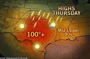
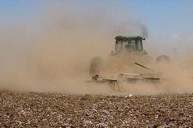
Month-Long Heat Wave Shows No Signs Of Waning. AccuWeather has an eye-opening update on the intense heat and drought gripping much of the south. Some of the statistics really are amazing: "Even more impressive, Laredo, Texas, has cracked the century mark each day since May 18, a stretch of 29 days and counting! Not to be outdone, Wichita Falls, Texas, has been 100 or higher each afternoon since June 2. To present statistics and records from each city would certainly be overload. However, here are a few eye-popping statistics from a very long and very intense early season heat spell:
--Temperatures have been at or above 90 since the last full week of May at countless reporting stations across states including Texas, Oklahoma, Arkansas, Louisiana, Mississippi, Alabama, Florida and Georgia.
--Laredo, Texas, has already recorded 51 days of temperatures at or above 100 so far this year. By this point last year, there were only 12 such days.
--Tallahassee, Fla., recorded a high of 105 on Wednesday, setting a new all-time record high for any month.
--Several locations have set record highs for the month of June. Included in this is Houston, which reached 105 on both June 5 and 6.
--Virtually every location is averaging 5 to 10 degrees above normal so far this month. Wichita Falls, Texas, is an astounding 9.7 degrees warmer than normal, while Columbus, Ga., isn't much farther behind at about 8 degrees above normal.
Hot Weather Factoids:
--Temperatures have been at or above 90 since the last full week of May at countless reporting stations across states including Texas, Oklahoma, Arkansas, Louisiana, Mississippi, Alabama, Florida and Georgia.
--Laredo, Texas, has already recorded 51 days of temperatures at or above 100 so far this year. By this point last year, there were only 12 such days.
--Tallahassee, Fla., recorded a high of 105 on Wednesday, setting a new all-time record high for any month.
--Several locations have set record highs for the month of June. Included in this is Houston, which reached 105 on both June 5 and 6.
--Virtually every location is averaging 5 to 10 degrees above normal so far this month. Wichita Falls, Texas, is an astounding 9.7 degrees warmer than normal, while Columbus, Ga., isn't much farther behind at about 8 degrees above normal.
Houston, Texas Entering "Uncharted Territory". I don't think I've ever seen a National Weather Service statement like this one. Almost apocalyptic:
RECORD HIGH TEMPERATURES COUPLED WITH WINDIER THAN NORMAL CONDITIONS
HAVE EXACERBATED DROUGHT CONDITIONS. HOUSTON RECORDED 100 DEGREES ON
JUNE 2 2011. THIS IS THE EARLIEST 100 DEGREE TEMPERATURE RECORDED IN
CITY HISTORY. A FEW DAYS LATER...THE HIGH TEMPERATURE SOARED TO 105
DEGREES IN HOUSTON AND 99 DEGREES IN GALVESTON. HOUSTON ESTABLISHED A
NEW HIGH TEMPERATURE RECORD FOR THE MONTH SURPASSING THE PREVIOUS
WARMEST JUNE TEMPERATURE OF 104 DEGREES. GALVESTON TIED IT'S WARMEST
JUNE TEMPERATURE WITH A HIGH TEMPERATURE OF 99 DEGREES. THE AVERAGE
HIGH TEMPERATURE FOR THE FIRST 15 DAYS OF JUNE IS THE WARMEST ON
RECORD FOR THE THREE OF THE FOUR PRIMARY CLIMATE SITES. BELOW ARE
THE FIVE WARMEST AVERAGE HIGH TEMPERATURES FOR JUNE 1ST THROUGH JUNE
15TH:

          CITY OF      HOUSTON      COLLEGE      GALVESTON
          HOUSTON      HOBBY        STATION

          98.2 2011    96.5 2011    99.3 1911    91.4 2011
          96.1 1902    94.9 1963    98.9 2011    90.5 2008
          95.6 1911    94.8 1998    98.0 1958    89.9 1875
          94.7 1990    93.7 1953    96.4 1960    89.3 1881
          94.5 2008    93.6 2008    95.9 1953    88.9 2000

THE CITY OF HOUSTON HAS ENTERED UNCHARTED TERRITORY. HOUSTON HAS
ENDURED FOUR CONSECUTIVE MONTHS WITH LESS THAN AN INCH OF RAIN
TALLIED IN EACH MONTH. THE CITY OF HOUSTON HAS NEVER RECORDED THREE
CONSECUTIVE MONTHS WITH LESS THAN AN INCH OF RAIN...LET ALONE FOUR
CONSECUTIVE MONTHS. SINCE JANUARY 26TH...THE CITY OF HOUSTON HAS
RECEIVED 2.05 INCHES OF RAIN AND HOBBY AIRPORT HAS RECEIVED EVEN
LESS...A PALTRY 1.41 INCHES OF RAIN. HOBBY AIRPORT HAS ONLY RECORDED
ONE DAY WITH MEASURABLE RAIN OUT OF THE LAST 92 DAYS (0.19 INCHES ON
MAY 12TH). OTHERWISE...THE FEW RAIN EVENTS THAT HAVE CLIPPED THE
AIRPORT HAVE ONLY DROPPED TRACE AMOUNTS OF RAINFALL. THE NWS OFFICE
IN LEAGUE CITY HAS REPORTED SIX DAYS OF RAIN SINCE MARCH 15TH WITH A
DISCOURAGING 92 DAY RAINFALL TALLY OF 0.36 INCHES.

IT IS STILL THE DRIEST OCTOBER 1ST THROUGH JUNE 16TH IN CITY OF
HOUSTON WEATHER HISTORY. HOBBY AIRPORT IS ALSO ENDURING ITS DRIEST
PERIOD ON RECORD. COLLEGE STATION REMAINED THE SECOND DRIEST PERIOD
ON RECORD AND DANEVANG REMAINED THE FIFTH DRIEST PERIOD ON RECORD.
EVEN GALVESTON...WHICH RECEIVED SOME MODERATE RAINFALL TOTALS IN
DECEMBER AND JANUARY IS ENDURING IT'S SIXTH DRIEST PERIOD ON RECORD.
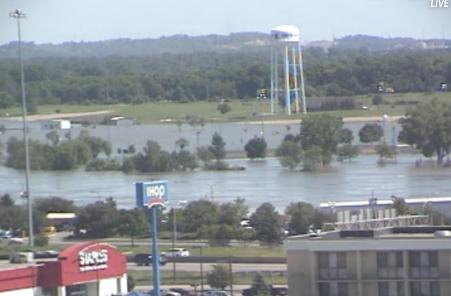
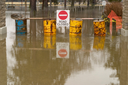
Water reached the 8-foot-tall levee late Wednesday, Army Corps of Engineers spokesman Carlos Lazo said. There were no immediate problems reported along the structure, where officials expect about 5 feet of water to eventually collect.
The water appeared to be about 2 feet deep Thursday morning, according to an Associated Press reporter in Hamburg.
Crews finished work on the 3-mile-long levee on Wednesday by covering it with plastic to reduce erosion. And most of those living in the threatened parts of town have cleared out.
* Photo above courtesy of MSNBC.
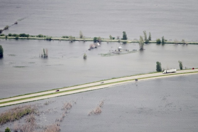
Missouri River Flooding. The
Des Moines Register has a series of photos documenting the extensive flooding in far western Iowa - absolutely incredible.
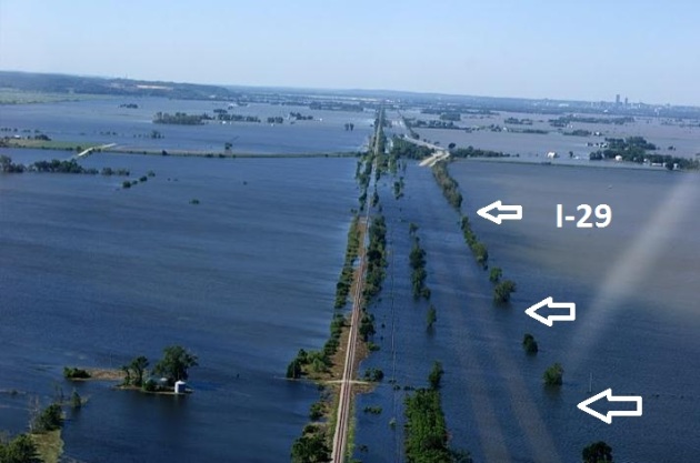
The Mighty Missouri River Defies The Army. The photo above is one of
113 remarkable photos from Larry Geiger - check out the images in his Picasa library - it really puts the scope of the flooding into perspective. This picture was taken north of Omaha, looking south (that's Interstate 29 to the right, totally inundated under 5-15 feet of water). The
Bismarck Tribune has more details on the battle to save communities on either side of the Missouri as record May rains, coupled with rapidly melting snow in Montana and Wyoming, surge downstream toward the Mississippi River: "
In the nearly two-centuries-long interaction between the Missouri and the Army Corps of Engineers, the river has repeatedly defied the Army's attempts at control. Today, the Army faces the greatest challenge to its regulation of the Mighty Mo. As of June 14, the Fort Peck reservoir was at 114.2 percent of capacity. The lake is so full that water is now flowing through the dam's emergency spillway. Because the Army does not have the ability to halt the flows through the spillway without threatening the structural integrity of the dam, the dam and reservoir have lost the ability to curtail the Missouri. For all intents and purposes, the Missouri has defeated Fort Peck Dam. Water is just passing through the reservoir and moving on downstream. But that isn't even the full story. The Rocky Mountain snowpack in Montana is now beginning to melt in earnest. In places, that snowpack is at 140 percent of normal. All of that melt water is just going to pass through Fort Peck reservoir. Then there is the issue of rainfall. June is the wettest month of the year on the Northern Plains and within Montana. The rains are going to come. The National Weather Service has predicted above-average rainfall for June in Montana because of the presence of La Nina in the Pacific. As a matter of fact, portions of the Upper Missouri Basin may receive heavy, drenching rains in the next few days. All of that water is going to pass through Fort Peck reservoir. The next bulwark against the Missouri is Garrison Dam, 70 miles north of Bismarck. Garrison is a colossus. The dam rises 210 feet above the riverbed and stretches a little over two miles long from valley wall to valley wall. Lake Sakakawea's elevation is 1,854 feet above sea level when at full capacity. On June 14, the reservoir level was at 1,853.38 feet. The Missouri is only inches from entering the dam's spillway. With all the water currently moving through the unregulated Yellowstone (75,000 cfs at Sidney, Mont., near the river's mouth) and the now-moot Fort Peck reservoir (with an inflow of 86,000 cfs into its reservoir), and the water still to come, the Missouri will surely enter Garrison's spillway, defeating the regulatory ability of the second of the Army's large dams."
.
UStream has a live feed of the flooding underway in Sioux City, Iowa.
Global Temperatures Were 10th Warmest On Record For May. The latest from
NOAA: "
The globe experienced the 10th warmest May since record keeping began in 1880, as the climate phenomenon La Niña ended its 2011 cycle. The Arctic sea ice extent was the third smallest extent for May on record. The monthly analysis from NOAA’s National Climatic Data Center is part of the suite of climate services NOAA provides government, business and community leaders so they can make informed decisions.
Global temperature highlights: May
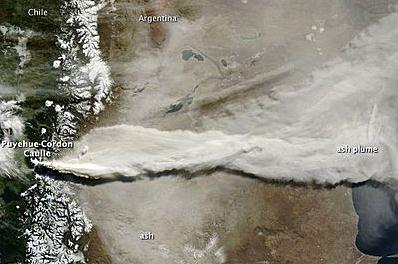
Volcanic Eruption In Chile. A volcano dormant for decades erupted Wednesday, sending a cloud of steam and ash 6-10 miles into the stratosphere. At least 3,500 local villagers had to be evacuated - the ash cloud disrupted air travel across much of the southern hemisphere, including Australia and New Zealand.
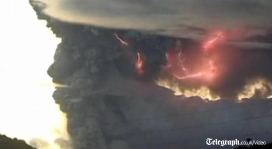
"Volcanic Lightning." This is an amazing
video clip from the Telegraph. The ash and steam cloud is rising so violently it's producing lightning and thunder - a volcano-storm!
Chilean Volcano Fills Lake With Ash. From the U.K.
Telegraph: "
The volcano, dormant for decades, has been spewing clouds of ash more than 6 miles high for the past ten days. Northeasterly winds have blown the ash into neighbouring Argentina where flights have been severely disrupted. Lake Nahuel Huapi is Argentina's largest lake at 210 square miles and it lies in the eastern foothills of the Andes. The Puyehue-Cordon Caulle volcanic chain located about 575 miles south of the Chilean capital Santiago last saw a major eruption after a magnitude 9.5 earthquake hit the country in 1960."
 Weekend Weather Details
. Don't panic. It won't be quite this wet (at least not in the St. Cloud metro area), but there will be some heavy showers and storms. Bottom line:
the farther south/west you go, away from the Twin Cities, the nicer this weekend should be. The farther north/east you drive, toward Mille Lacs, Brainerd Lakes, Duluth and western Wisconsin resorts, the soggier conditions will probably be. Here's a summary:
Saturday
Duluth: 52//59 Rain/T-storms likely. Winds: E 15-25
Brainerd: 57/68 Rain/Storms Winds: N 5-10
St. Cloud: 58/75 Wet start, some PM sun. Winds: NW 7-12
Twin Cities: 65/80 Soggy start, some PM sun. Winds: NW 8-13
Mankato: 66/83 Wet start, plenty of sun. Winds: NW 10+
Alexandria: 62/76 Few T-storms nearby. NW 10-15
Sunday
Duluth: 54/64 Lingering showers. Soggy. Winds: NE 15
Brainerd: 58/72 AM showers, PM sun. Winds: NE 10
St. Cloud: 59/76 Wet start, getting sunnier. Winds: E 5-10
Twin Cities: 66/82 Partly sunny, dry most of day. Winds: SE 5-10
Mankato: 67/84 Sunshine, probably dry. Winds: SE 10
Alexandria: 63/80 Partly sunny, nicer day? Winds:
E 10
Sloppy Grandma's Marathon? Pack the rain gear. Do yourself a favor. You won't have to worry about overheating this year in the long jog from Twin Harbors to Duluth. Expect temperatures in the 50s, periods of rain, fog (even a clap of thunder), an east wind at 10-15 with gusts to 20. Yes, it will feel more like late September. Sorry - hope I'm wrong.
- Grandma’s is without question the granddaddy of Duluth’s special events -- actually Duluth’s biggest event.
- Duluth’s population almost doubles, swelling with more than 15,000 racers and 55,000 race fans.
- Grandma’s Marathon alone has an estimated $8.5 million economic impact on our community — in less than a week.
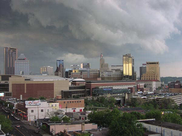
Slight Risk of Severe Storms. According to SPC much of central and southern Minnesota is in a slight threat of severe thunderstorms later today - the best chance of hail and damaging winds coming Friday evening. I suspect a Severe Storm Watch later today. We'll see.
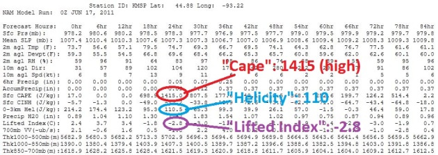
Potentially Ripe. Although I do NOT expect a rerun of June 17, 2010 - we have many of the ingredients necessary for a severe storm outbreak, especially south/west of the Twin Cities and St. Cloud. By the dinner hour "Cape" values are forecast to top 1400, moderate instability. The "Helicity" (a measure of wind shear) is low to moderate, and the "Lifted Index", another stability parameter, is close to -3 (anything under 0 is unstable). Not sure we'll see any large, violent tornadoes, but a couple of small tornadoes, maybe a squall line with 60 mph winds and quarter-size hail? It could happen after 4 pm or so.
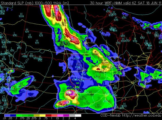 Friday Evening Storms
. This (NAM) model output is valid at 1 am Saturday morning, showing expected rainfall amounts between 7 pm this evening and 1 am tomorrow. The greatest potential for rain (and a few severe storms)
is forecast to come south/west of the Twin Cities and St. Cloud.
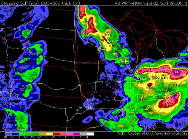 Saturday Evening
. After a wet start Saturday skies will try to clear over parts of central and southwestern Minnesota - there may be some sun in the Twin Cities metro by afternoon or evening, but that slow-moving warm frontal boundary will spark more heavy showers and T-storms just north and east of the metro area. It may stay wet (and thundery) from the Brainerd Lakes area into the St. Croix River Valley much of the day on Saturday - the chance of a nice Saturday PM increasing the farther west you drive on 7/212. Bottom line: from MSP
on south/west the weather
should get better as the day goes on Saturday. North/east of St. Cloud? Keep your expectations low tomorrow.
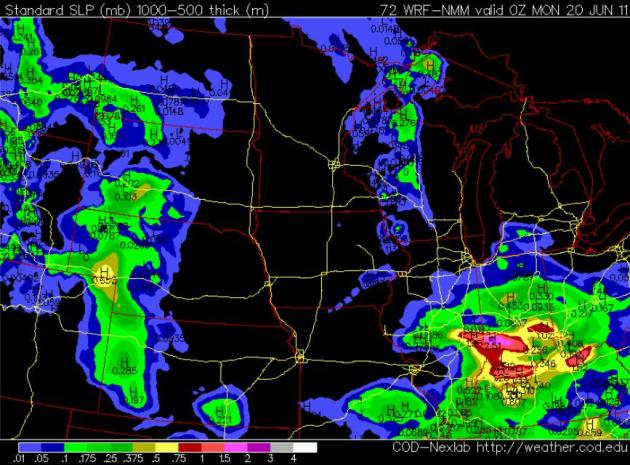
Sunday: Getting Better. For much of Minnesota (especially up north) Sunday will probably be the better day for the lake. Showers will slowly taper off up north (lingering much of the day in the Duluth area and much of western/central Wisconsin). The sun should be out much of the day, especially afternoon hours. Your best chance of salvaging some decent weather will probably come Sunday afternoon/evening. I know - just about the time you have to pack up and head home.
Before We Go.... (sorry, can't get the stupid Broadcast TV lingo out of my brain, try as I may):
Solar Bikini Goes Into Very Limited Production. Breaking news: if you're too lazy to charge your iPhone the night before, or you want to power your iPad when the sun is shining, then this incredible (wearable) breakthrough may be for you. Yes, now I've officially "seen everything".
Gizmag.com has the story: "
Those lucky enough to be currently enjoying the Northern Hemisphere summer will no doubt be heading for the beach for a good bronzing as often as possible. These days, of course, the digital device is an important part of the sun worshiper's kit, and making sure they have enough battery power to go the distance can be a major concern. The Solar Bikini from New York designer Andrew Schneider is said to be capable of charging a smartphone or media player while the wearer lays back and soaks up the summer sun. Now available for custom order, each bikini sports 40 thin and flexible photovoltaic strips connected by conductive thread, which ends at a USB port."
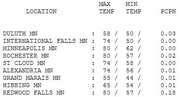 A Fine Thursday
. After a gray start the sun finally came out around midday, enough PM sun for highs ranging from
74 in St. Cloud to 80 in the Twin Cities, Rochester and Redwood Falls. With a damp wind off Lake Superior (and a dense fog advisory to boot), Duluth only struggled to a high of 58.
 Paul's SC Times Outlook for St. Cloud and all of central Minnesota:
TODAY: Humid with some morning/midday sunshine. Late PM T-storms, some severe. Winds: SE 15-25. High: 76
FRIDAY NIGHT: Showers and T-storms likely, some strong to severe. Low: 62
SATURDAY: Wet start, becoming partly sunny midday/PM hours. Rain/storms linger up north. Winds: NW 8-13. High: 78
SATURDAY NIGHT: Patchy clouds, an isolated shower or T-storm (best chance north/east of the metro). Low: 66
SUNDAY: Nicer day of the weekend. Partly sunny much of the day; any morning showers/storms should give way to clearing later in the day. Winds: SE 5-10. High: 80
MONDAY: Intervals of sun - a stray T-storm. Low: 63. High: 82
TUESDAY: Unsettled, more PM storms. Low: 62. High: 77
WEDNESDAY: Storm aloft lingers, few more showers. Low: 60. High: 76
THURSDAY: Partly sunny, cooler, less humid. Low: 56. High: 74
"Okla-Sota"
A year ago today stunned Minnesotans witnessed the largest single-day tornado outbreak in our state's history: 48 separate tornadoes, including an EF-4 monster than swept through Wadena. There was ample warning; everyone knew it would be a very bad day for severe weather, but nobody was prepared for 4 dozen twisters in the span of a few hours; 16 of them strong/violent tornadoes. According to the National Weather Service 87 tornado warnings were issued in a 12-hour period, with an average lead time of 19 minutes, well above the 13 minute national average. The death toll could have been far worse. We got lucky.
In spite of the recent Minneapolis tornado I'm still concerned about complacency. The NWS does an amazing job, but we need an even better warning system, one that triggers cell phone alerts for ONLY the people in the immediate path of a tornado. Relying on Doppler radar, 70% of warnings turn out to be false alarms - and we get accused of "crying wolf." There's a better way.
Ironically, another severe outbreak is possible today, even a few isolated tornadoes (best chance southwest MN). Stay alert. Most of the weekend will be dry; intervals of sun and (spotty) T-storms Saturday, Sunday looks like the sunnier, drier day as showers/storms push out of central Minnesota.
Scientists See More Deadly Weather, But Dispute The Cause. Fluke, coincidence or trend? Are all these extreme weather and climate events interrelated? The
New York Times has the story: "
WASHINGTON — The United States experienced some of the most extreme weather events in its history this spring, including deadly outbreaks of tornadoes, near-record flooding, drought and wildfires. Damages from these disasters have already passed $32 billion, and the hurricane season, which is just beginning, is projected to be above average, according to the National Oceanic and Atmospheric Administration. Government scientists said Wednesday that the frequency of extreme weather has increased over the past two decades, in part as a result of global warming caused by the accumulation of carbon dioxide in the atmosphere. But they were careful not to blame humans for this year’s rash of deadly events, saying that in some ways weather patterns were returning to those seen at the beginning of the last century. “Looking at long-term patterns since 1980, indeed, extreme climatological and meteorological events have increased,” said Thomas R. Karl, director of NOAA’s National Climatic Data Center. “But in the early part of the 20th century, there was also a tendency for more extreme events followed by a quiet couple of decades.” Presenting a new NOAA report on 2011 extreme weather, Dr. Karl said that extremes of precipitation have increased as the planet warms and more water evaporates from the oceans. He also said models suggest that as carbon dioxide builds up in the atmosphere and heats the planet, droughts will increase in frequency and intensity."
A Year Of Weather Extremes. Mississippi's
sunherald.com has the story from a different angle: "
There is no doubt this spring has been one of weather extremes: drought in the South, tornadoes in the middle part of the country and flooding all along the Mississippi River. Weather experts at the National Oceanic and Atmospheric Administration said Wednesday the one common factor is La Niña, but this type of weather isn’t the norm and doesn’t mean a pattern of bad weather is forming. NOAA officials held a webinar Wednesday to talk about this spring’s weather and the rain forecast for summer. “It takes a truly extraordinary year for this to happen,” said Harold Brooks, a meteorologist with the National Severe Storms Laboratory. “We have no reason to think this indicates a shift. These are the kinds of years that are rare. La Niña was present last winter and this spring, which means the waters of the Pacific are cooler. Typically, La Niña causes excessive rainfall in the north and drought in the south. The rain and snow in the winter contributed to the flooding along the Mississippi River. The precipitation forecast calls for Mississippi and the rest of the southeast to enter into a more-normal rainfall pattern between July and September, although NOAA officials said that is uncertain. South Mississippi has been in an extreme drought for more than a month and is 15 inches below normal for rainfall this year. As for the tornadoes, NOAA said this year may have the most on record, although it is still compiling statistics. The current record was set in May 2003 with 542 tornadoes. Brooks said the most active time was the last two weeks of April when tornadoes hit in Mississippi, Alabama and Missouri. The tornado in Joplin, Mo., is the seventh deadliest single tornado on record with 151 deaths, and there could be a few more. This year is the sixth deadliest with 536 deaths so far. The deadliest year was 1925 with 794 deaths."
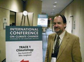
Did "#1 Climate Change Denier" Fake His Resume? Mother Jones has a follow-up report on Don Shelby's story at Wednesday's Minnpost.com: "
Sometimes it seems hard to believe how much skepticism still exists about climate change, with the scientific community in near-unanimous agreement that yes, it's happening and yes, it's our fault. But as Minnesota State Senator Michael Jungbauer reminded us yesterday, most of that dissent comes from people who are more or less clueless about the science. Jungbauer, who sits on the state's Senate Energy, Utilities and Telecommunications Committee, proudly calls himself the "No. 1 global warming denier in Minnesota." He also claims to have a bachelor's degree from the Moody Bible Institute with a "background in biochemistry." The first claim is easy enough to believe, but as for the second, MinnPost reported yesterday that Jungbauer never graduated, and that the closest thing he has to a bachelor's of science is a ministerial ordainment from Christian Motorsports International, which provides "chapel services" at "races, car shows, cruise-ins, and tractor pulls."
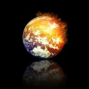
5 Huge American Cities Battle Climate Change. A story from
247wallst.com: "
The risks posed by global climate change is still uncertain. What is known is that the polar ice caps have melted quickly over the last decade, the hole in the ozone layer has grown, and weather patterns have changed substantially. There are some experts who believe that climate change and global warming are myths, but they are in the minority. While there is a consensus in the scientific community that climate change is a serious problem, the same cannot be said for the general public. According to a recent Gallup poll, nearly 50% of Americans “now believe that the seriousness of global warming is generally exaggerated, up from 41% in 2009 and 31% in 1997,” when Gallup first asked the question. For officials in some cities, however, the problem is very real. For one thing, pollution causes asthma and other diseases that can be expensive to treat. Beyond that, clean cities are more attractive to both businesses and people. No city wants to lose taxpayers because it is considered “dirty.” Environmental quality is also an important part of business development. Cities can draw businesses with tax breaks, but even the most generous of incentives may not be enough to overcome concerns about a city’s cleanliness or lack of preparedness regarding climate change. Regardless of whether the debate is resolved in the scientific community or in the public’s mind, the leaders of many of the largest cities on earth have decided that it is better to operate under the assumption that the worst could occur."
The Climate Cabinet Is Ready. Are You? This post from Vermont's
Brattleboro Reformer:
"I remain baffled as to how anyone -- Democrat, Republican, Progressive -- can look at the evidence that's before our eyes, look at the scientific data and not have [climate change] be the top priority of everything that we do, not only in government, but in our own personal and private lives." -- Governor Peter Shumlin, 2006 "
Two weeks ago I awoke to my daughter telling me that school was cancelled because of flooding. I was awakened many times during the night by the storm, but the flooding and destruction it caused took me, and all Vermonters, by surprise. As we toured the damage, people stopped to ask me whether the heavy rain and floods we experienced this spring are from global climate change. Of course, it is hard to know for sure, but climate scientists have been predicting for years that climate change will result in droughts, floods and other extreme weather events. Indeed, over the past 10 years Vermont has experience eight of the most extreme one-day precipitation events in our recorded history."
IPCC "Considering Sending Mirrors To Space To Tackle Climate Change". Tinkering with aerosols in the Earth's stratosphere? Call me crazy, but this sounds like a bad idea to me. "Correcting" the problem of a warming planet may have some unintended side-effects. The U.K.
Telegraph has the story: "
The Intergovernmental Panel on Climate Change (IPCC) papers, leaked ahead of a key meeting in Peru next week, outline the series of techniques in which scientists hope will manipulate the world’s climate to reduce carbon emissions. Among the ideas proposed by a group of 60 leading scientists from around the world, including Britain, include producing “lighter coloured” crops to reflect sunlight, blasting aerosol “mirrors” into the stratosphere and suppressing cirus clouds. Other suggestions include spraying sea water into clouds as another reflection mechanism, depositing massive quantities of iron filings into the oceans, painting streets and roofs white and adding lime to oceans. Experts suggested that the documents, leaked from inside the IPPC to The Guardian, show how the UN and other developed countries are “despairing” about reaching agreement by consensus at the global climate change talks. But the newspaper reported that scientists admit that even if the ideas theoretically work, they could cause irreversible consequences."


No comments:
Post a Comment