 Today
Today: Warmer day of the weekend with tropical humidity levels (
dew points in the 70s!) Expect a partly sunny sky with scattered T-storms, some heavy. With a puddle of unusually cold air swirling aloft there's even an outside chance of a few (isolated) severe storms with small hail. Winds will blow from the southeast at 7-12 mph.
 Sunday: Go West Young Man
. Showers and T-storms may linger much of the day from Duluth to MSP,
the best chance of showers and storms east of I-35. The weather should get sunnier/drier farther west, a partly sunny sky from the Brainerd Lakes and Alexandria to Duluth and Willmar. Winds blow from the northeast at 8-13 with a noticeable drop in temperature and humidity behind a weak cool front.
 Record Year For Weather Disasters?
 "
Just past the halfway point, 2011 has already seen eight weather-related disasters in the U.S. that caused more than $1 billion in damages." - excerpt from a
Scientific American article below.
 Expanding Drought
. According to NOAA it's the largest area of "exceptional drought" ever measured. Details below.
 June 7, 2011: 103 in the Twin Cities
. That's the hottest temperature ever recorded (anywhere in the state of Minnesota) for June 7, according to Mark Seeley. More details below.
 Insane Extremes.
 How is this even possible in the same country? While the south and east broils, over 100" snow remains on the ground over the higher terrain of Montana. A sudden thaw, coupled with heavy rain, is flushing all that meltwater into the Missouri River Basin - flooding will probably worsen in the weeks ahead.
 No Need To Water Anytime Soon
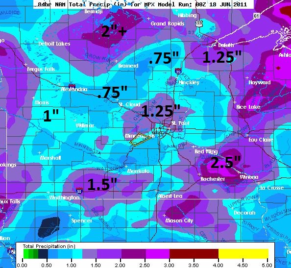
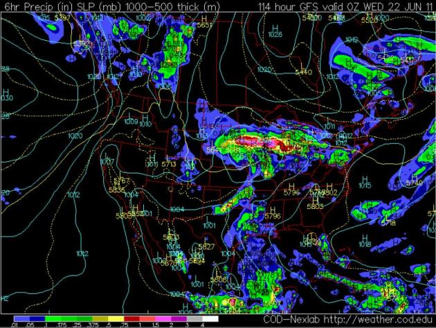
. A slow-moving front will spark numerous showers and T-storms, the NAM printing out over 1" of rain for much of the metro area, with some 2"+ amounts from near Albert Lea and Rochester to Eau Claire and Rice Lake, Wisconsin.
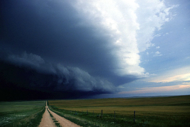
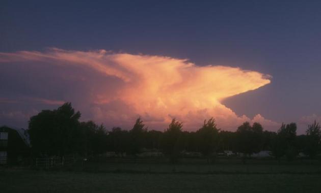
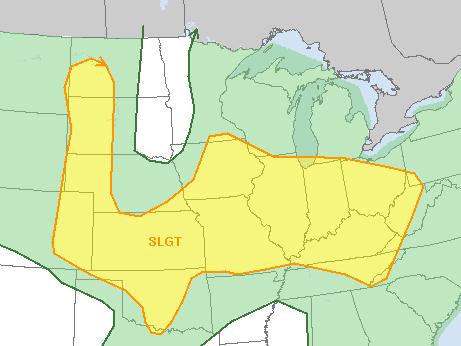 Severe Risk Diminishes Today
. SPC still has far southern Minnesota on the edge of the "slight risk" area. A few storms over eastern Minnesota and western Wisconsin may approach severe limits, with small hail and winds approaching severe limits (58 mph). Stay alert: the best chance of strong/severe storms will come around the dinner hour.
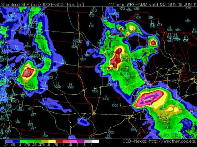
 Saturday: Scattered Storms (best chance eastern Minnesota)
. After a very soggy start the sun should break through by midday, more instability T-storms popping by mid/late afternoon, especially from the Arrowhead southward through the metro and St. Croix River Valley into western Wisconsin. NAM model map above valid 1 pm Saturday afternoon.
Overview: Today will be the warmer, muggier day of the weekend: highs in the low 80s with dew points above 70 - very drippy and tropical out there.
Winds: SE 7-12. Steady barometer.
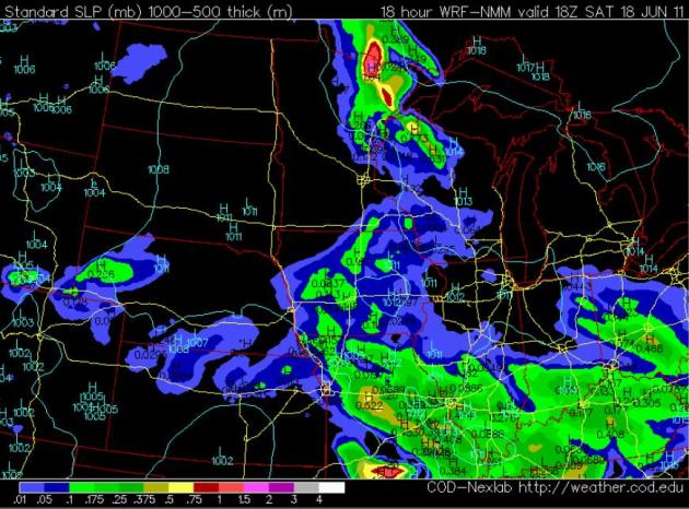
 Sunday: Best Chance of T-storms East of I-35.
 The farther west you hang out tomorrow, the sunnier (and drier)
the weather should be. A weak cool frontal passage should mean cooler temperatures and a drop in humidity. The heaviest rains are forecast from southeastern Minnesota into western Wisconsin, where some 1"+
amounts are possible. NAM model map above valid 1 pm Sunday.
Overview: Expect partly sunny skies over the western half of Minnesota with a drop in humidity. Showers and T-storms linger from Duluth southward to the Twin Cities, Rochester and Red Wing, and much of Wisconsin, where rain may be locally heavy. Winds:
NE
8-13. Slowly falling barometer.
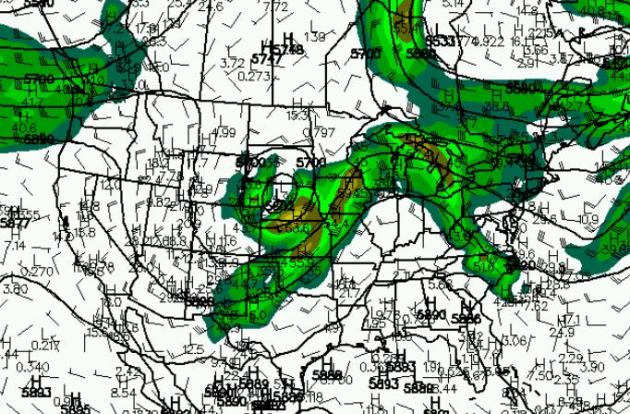
Significant Storm Early Next Week? Both the GFS and the (European) ECMWF models show a very springlike pattern early next week, an unusually strong jet stream howling 500-800 miles farther south than usual, whipping up a deep area of low pressure over western Iowa by Tuesday evening. If the warm front surges far enough north and we break out into the "warm sector" of this system - the potential for a widespread severe storm outbreak will be significant from Monday into Tuesday of next week.
What Month Is This Again? The Summer Solstice is upon us - but why do the weather maps look like something out of April or early May? This is the predicted 500 mb wind pattern for next Tuesday morning, showing a "closed low" over Nebraska, 75-100 mph winds some 5-8 miles above the ground, howling from the southwest, creating sufficient wind shear for a possible tornado outbreak close to home. It's way too early for specifics - just know the pattern may be ripe for some damaging T-storms next Monday and Tuesday, the risk diminishing Wednesday as the storm pushes east.
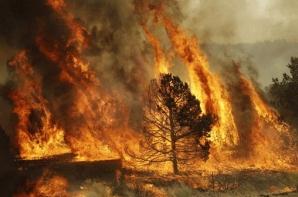
The Worst Wild Fires In World History? I didn't realize that America's worst fire took place in Wisconsin and the U.P. of Michigan in 1871. Dr. Jeff Masters has a comprehensive review of the world's worst blazes, and tries to put Arizona's "Wallow Fire" into perspective in his excellent
Wunderblog:
"The Wallow Fire in Arizona and New Mexico has now become the largest in history for the southwestern United States with over 745 square miles (476,800 acres) charred so far, surpassing the Rodeo-Chediski fire of 2002. I thought this an opportune time to look back and compare the magnitude of the fire with those in the past in both the United States and around the world....The single worst wild fire in U.S. history, in both size and fatalities, is known as the Great Peshtigo Fire which burned 3.8 million acres (5,938 square miles) and killed at least 1,500 in northern Wisconsin and the Upper Peninsula of Michigan during the week of October 8-14, 1871. Many sources put the size of the fire at 1.2-1.5 million acres but that included only the area that was completely burned and not the additional 2.3 million acres in surrounding counties that also suffered burn damage (see maps below). Unattended fires at logging camps in the area most likely caused the fire. After a long hot and very dry summer strong warm autumn winds from the southwest fanned the fires out of control. Fire tornadoes were reported at several locations and the fire became so hot that people taking refuge in rivers were boiled to death."
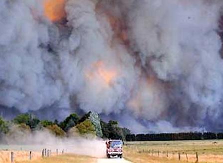
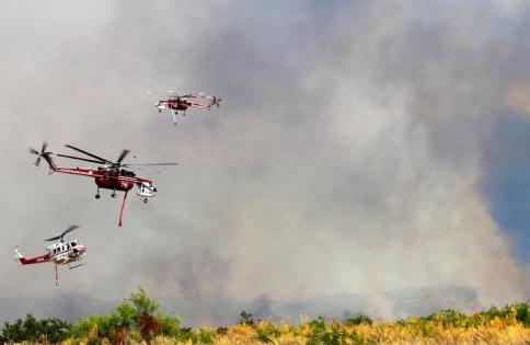 Arizona Wildfires Force Chaotic Evacuation
.
USA Today has the latest on the fires, which continue to spread across the south, fanned by tinder-dry humidity and winds gusting over 40 mph at times: "
PHOENIX -- The Monument fire burning in southern Arizona nearly doubled in size in less than 12 hours, leading to more notices of possible evacuation, authorities said Friday. Arizona Gov. Jan Brewer declared a state of emergency Friday for Cochise County because of two wildfires in the area, Monument and Horseshoe Two. Though the Monument fire is about 4% the size of the 773-square-mile Wallow fire, which began May 29 in northeast Arizona, it already has burned more homes: at least 40 vs. about three dozen. "Once that thing starts to run, it's running like a freight train," Chief Deputy Rod Rothrock of the Cochise County Sheriff's Office said of the Monument fire, which began Sunday but surged out of control Thursday, prompting evacuation of an unincorporated area south of Sierra Vista, Ariz., that has 3,200 homes. Police, county sheriff's deputies and fire officials swarmed neighborhoods Thursday with sirens blaring and officers on speakers imploring, "You've gotta get out now!" Many of the residents chaotically evacuated were allowed back home Thursday evening to retrieve pets, livestock, papers and other important items. They had to leave again by Friday morning. But not all were able."
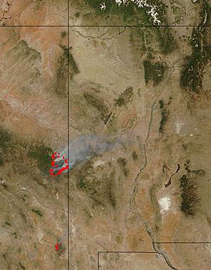
Cool Images Of The Week.
AccuWeather has a collection of some of the more interesting satellite images of the week, courtesy of NASA and NOAA. Photo credit for image above:
"By the end of the day on June 9, 2011, Arizona's massive Wallow Fire had reached 386,690 acres (609 square miles or 157,701 hectares) and had burned 29 and threatened 5,242 homes. Most of the homes destroyed were in Greer."
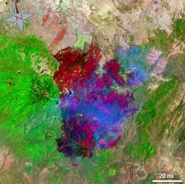
Landsat 5 Satellite Helps Emergency Managers Fight Largest Fire In Arizona History. NASA has the details: "
The largest fire in the history of the state of Arizona continues to burn and emergency managers and responders are using satellite data from a variety of instruments to plan their firefighting containment strategies and mitigation efforts once the fires are out. The Landsat 5 satellite captured images of the Wallow North and Horseshoe 2 fires burning in eastern Arizona on June 15, 2011 at 19:54:23 Zulu (3:54 p.m. EDT). Both images are false-colored to allow ease of identification of various objects that will help firefighters and emergency managers. In the images burn scars appear in red and ongoing fire in bright red. Vegetation is colored green, smoke is colored blue and bare ground is tan-colored. The Landsat 5 image is a false color image with a 7, 4, 2 band combination. The Wallow fire began May 29, 2011 in the Bear Wallow Wilderness area located in eastern Arizona. High winds and low humidity meant that by June 14, 2011 the Wallow Fire became Arizona’s largest wildfire to date with over 487,016 acres burned. On the morning of June 16 the fire is now 29 percent contained, according to Inciweb. Inciweb, the "Incident Information System" website, (www.inciweb.org) is an interagency all-risk incident information management system."
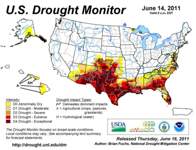
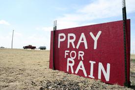 Largest "Exceptional Drought" Area On Record
. Summer heat usually peaks in August - it's unusual, almost unprecedented, to have such a huge amount of the USA experiencing severe/exceptional drought conditions in mid June. More details from
The Weather Channel: "
If it feels like your lawn is ready to shrivel up and blow away, you may not be wrong. According to the new drought monitor, 9% of the continental U.S. is in exceptional drought which is the worst drought level possible. This is the largest area of excpetional drought on record!
Drought Statistics
--281,000+ square miles in drought
--An area equal to the 13 Northeast states and Washington D.C.
--7.54% of U.S. (including Alaska, Hawaii, and Puerto Rico) in "exceptional drought"
"This is part of a remarkable meteorological 'haves and have-nots' story," says The Weather Channel Expert Stu Ostro. "(You have) record flooding and exceptional drought, and those two opposites occurring in close proximity to each other." For the past few months, Texas and the Southwest was the main drought region."
 Latest Drought Monitor.
 The "exceptional drought" designation has expanded from 8 states (last week) to 10 states (currently), tinder-dry conditions from
Arizona eastward to Georgia and much of Florida. Click
here to see the latest data from NOAA.
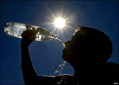
The Drought/Heatwave of '11. Here are some amazing statistics about the expanding heat wave gripping much of the south.
Last "below average" day in the temperature department:
· Memphis: May 27
· Houston: May 18
· San Antonio: May 16
· Atlanta: May 19
· Savannah: May 19
· Mobile: May 19
The 95 or above club:
- Houston, Texas: Through Thursday, 21 of the last 23 days have been 95 degrees or higher.
- Dallas, Texas: Through Thursday, 17 of the last 21 days have been 95 degrees or higher.
- Shreveport, La.: Thursday was the 16th day in a row with 95+ degree heat.
A month worth of 90s already:
- Atlanta, Ga.: Typically averages 9 to 10 days during June with 90-degree temps. June 2011 tally: 15
- Charlotte, N.C.: Typically averages 8 to 9 days during June with 90-degree temps. June 2011 tally: 11
- Birmingham: Typically averages 11 days during June with 90-degree temps. June 2011 tally: 16
 Hot Weather Trivia
. In this week's edition of
WeatherTalk, Professor Mark Seeley answers a question about extreme heat:
Question: "
You mentioned last week that the 103 degrees F reported at MSP on June 7th was a new all-time state record. Is that the only all-time state high temperature record held by the Twin Cities? I cannot find others in your book."
Answer: "
State record high and low temperature values are sometimes tricky in that the record values for individual dates are often shared by different weather stations. Throughout the Minnesota records suburban climate stations like Stillwater, Forest Lake, Chaska, and Maple Plain hold all-time records or may be tied with other locations. For example, Maple Plain holds the all-time high temperature record for the month of May in Minnesota (112 degrees F on May 31, 1934). For the date of March 29, Gaylord, Stillwater and MSP ared tied for the record high with 83 degrees in 1986. But reviewing all of the temperature values for June 7th, 2011 I find that the 103 degrees F at MSP International Airport is an all-time state record high for the date and the only such record held exclusively by MSP. So that was quite a unique reading."
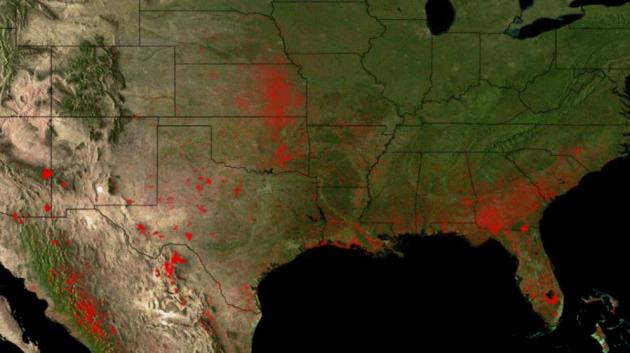 A Sea Of Wildfires In 2011
. A sustained ("exceptional") drought across the south, coupled with low humidity levels and gusty winds (and a few random cloud to ground lightning strikes) has ignited an unusual number of wildfires for so early in the season.
NOAA has the latest: "
Wildfires have plagued much of the Southern U.S. in 2011. The data shown here plots the locations of all wildfires detected by sensors aboard the NOAA AVHRR and GOES Imager, and NASA MODIS satellite sensors over the entire year-to-date. Each red point is one fire - and there are thousands of them plotted here. The data shows over 346,000 fires - though that is an overestimate since different satellites may double-count the same fire "target," but some may not see any at all. NCDC has tallied the number of U.S. wildfires at 33,109, but this number relies on human observations on the ground, which is probably an underestimate. The Okefenokee Swamp fire near the Florida-Georgia border, along with the Wallows fire in eastern Arizona are clearly visible as large red areas. The Okefenokee has been burning for months, and the Wallows is now the largest in Arizona history. Persistent droughts and high winds throughout much of the Southwest have created conditions ideal for wildfires during much of the winter and spring of 2011. Many of the fires in Texas, Oklahoma, and Nebraska are also drought-induced. The large fire signatures south of Lake Okeechobee in Florida are agricultural in nature."
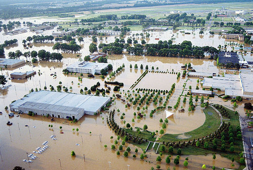
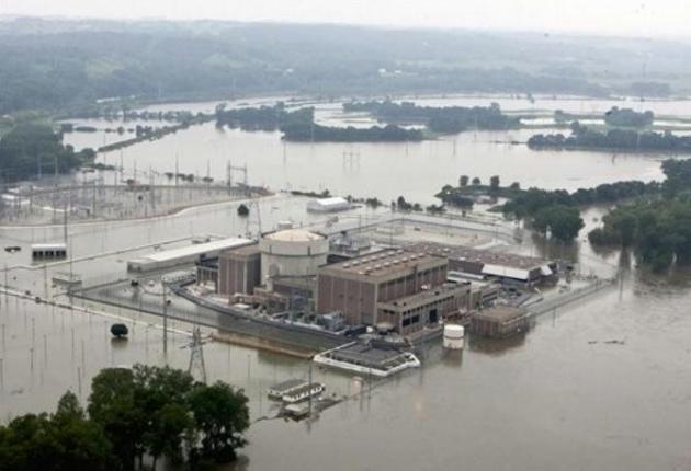
Flooding Missouri River Threatens Nebraska Nuclear Power Plant. O.K. Add one more potential concern to the epic flooding underway on the Missouri: a nuclear power plant (currently shut down, for obvious reasons). Here's the latest from
cryptome.org: "
The Fort Calhoun nuclear power station in Fort Calhoun, Neb. , currently shut down for refueling, is surrounded by flood waters from the Missouri River, Tuesday, June 14, 2011. On Tuesday, the releases at Gavins Point Dam in South Dakota hit the maximum planned amount of 150,000 cubic feet of water per second, which are expected to raise the Missouri River 5 to 7 feet above flood stage in most of Nebraska and Iowa. AP [The Missouri River is at lower right.]"
 Abominable Snowpack Lurking In Montana Mountains
. There is still a staggering amount of snow on the ground in the mountains of Montana, according to the
Bismarck Tribune. That snow is (finally) melting, water being flushed into the Missouri River Valley: "
BILLINGS, Mont. - Almost on cue, big rainy storm systems that saturated Eastern Montana in May are transitioning into a warmer, drier weather pattern fit for spring. But an abominable snowpack lurking in the mountains will make it a wet season with high water likely through July. Most Montana river basins had well above normal snowpack this winter and spring, and about 85 percent of it is still up there, according to Scott Oviatt, water supply specialist for the U.S. Natural Resources Conservation Service. It should have started melting a month ago, and rivers would normally be approaching their seasonal crests about now. This year, however, hasn't conformed to any pattern that could be called normal."Many sites are just now reaching their winter peaks in the last two weeks," Oviatt said. "The Bighorns and eastern Beartooths were still accumulating snow with that last storm." Statewide snowpack stands at 257 percent of average for this time of year, and some basins are much higher. The lower Yellowstone, the stretch of the river between Custer and the Missouri River, is at 308 percent of normal."
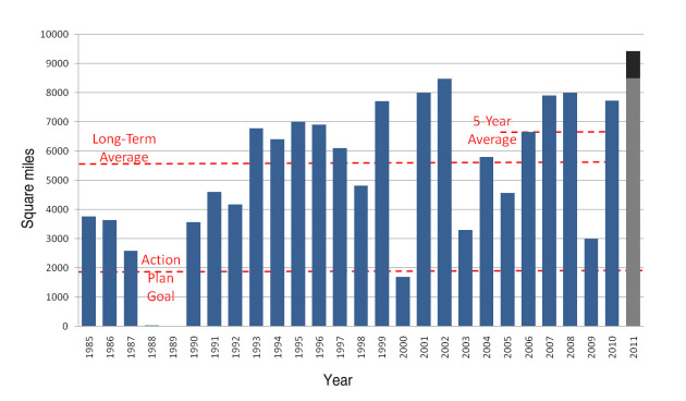
Major Flooding On The Mississippi River Predicted To Cause Largest Gulf of Mexico "Dead Zone" Ever Recorded. The latest from
NOAA: "
The Gulf of Mexico’s hypoxic zone is predicted to be the largest ever recorded due to extreme flooding of the Mississippi River this spring, according to an annual forecast by a team of NOAA-supported scientists from the Louisiana Universities Marine Consortium, Louisiana State University and the University of Michigan. The forecast is based on Mississippi River nutrient inputs compiled annually by the U.S. Geological Survey (USGS). Scientists are predicting the area could measure between 8,500 and 9,421 square miles, or an area roughly the size of New Hampshire. If it does reach those levels it will be the largest since mapping of the Gulf “dead zone” began in 1985. The largest hypoxic zone measured to date occurred in 2002 and encompassed more than 8,400 square miles. The average over the past five years is approximately 6,000 square miles of impacted waters, much larger than the 1,900 square miles which is the target goal set by the Gulf of Mexico/Mississippi River Watershed Nutrient Task Force. This collaboration between NOAA, USGS and university scientists facilitates understanding links between activities in the Mississippi River watershed and downstream impacts to the northern Gulf of Mexico. Long-term data sets on nutrient loads and the extent of the hypoxic zone have improved forecast models used by management agencies to understand the nutrient reductions required to reduce the size of the hypoxic zone. Hypoxia is caused by excessive nutrient pollution, often from human activities such as agriculture that results in too little oxygen to support most marine life in bottom and near-bottom water. The hypoxic zone off the coast of Louisiana and Texas forms each summer and threatens valuable commercial and recreational Gulf fisheries. In 2009, the dockside value of commercial fisheries in the Gulf was $629 million. Nearly three million recreational fishers further contributed more than $1 billion to the Gulf economy taking 22 million fishing trips."
NOAA Makes It Official: 2011 Among The Most Extreme Weather Years In History. No, you're not imagining it - the weather really has gone haywire this year. And with La Nina (Pacific cooling) now over, scientists are trying to connect the dots and determine WHY there have been so many extremes in 2011. Climate change? Or another factor that we're not even considering?
Scientific American has an update: "
The devastating string of tornadoes, droughts, wildfires and floods that hit the United States this spring marks 2011 as one of the most extreme years on record, according to a new federal analysis. Just shy of the halfway mark, 2011 has seen eight $1-billion-plus disasters, with total damages from wild weather at more than $32 billion, according to the National Oceanic and Atmospheric Administration. Agency officials said that total could grow significantly, since they expect this year's North Atlantic hurricane season, which began June 1, will be an active one. Overall, NOAA experts said extreme weather events have grown more frequent in the United States since 1980. Part of that shift is due to climate change, said Tom Karl, director of the agency's National Climatic Data Center. "Extremes of precipitation are generally increasing because the planet is actually warming and more water is evaporating from the oceans," he said. "This extra water vapor in the atmosphere then enables rain and snow events to become more extensive and intense than they might otherwise be."
May Losses $600 Million After $1.4 Billion Losses In April.
Reuters has an update on the staggering losses many big insurers are suffering, because of floods, drought and a record year for tornadoes: "
Allstate Corp (ALL.N), the largest publicly traded U.S. home and auto insurer, said it lost $2 billion in April and May from severe tornadoes and thunderstorms, nearly equaling its catastrophe losses for all of 2010. The devastating two-month period, taken as one block, now ranks as one of the worst in Allstate's history, alongside events like the 1994 Northridge earthquake in California and Hurricane Andrew in 1992.....For the industry as a whole, severe weather events in just one week in late May may result in insured losses of $4 billion to $7 billion, according to risk modeling agency AIR Worldwide. The two major U.S. tornado outbreaks in May and April were the costliest in history, the agency said."
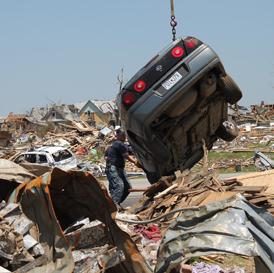
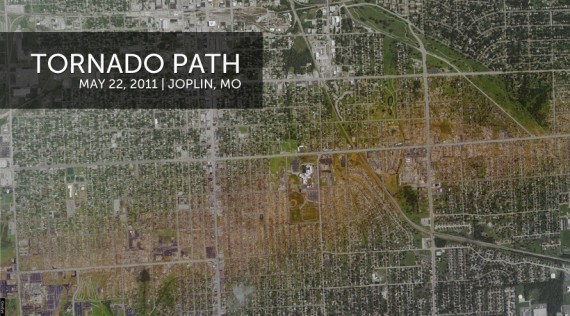
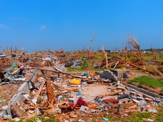
Most Tornado Fatalities Occurred Where People Lived. I realize this headline is a bit confusing; an easier way of saying this is that most Joplin tornado victims died in their homes, due to inadequate shelter (or no shelter at all). As I've been saying for months: if an EF-4 or EF-5 tornado is approaching and you don't have a basement, or a reinforced (concrete/steel) "safe room", your odds of survival aren't very good. More details on what researchers have learned from the devastating Joplin tornado from the
Joplin Globe: "
Globe reporters were able to pinpoint where the storm hit 106 victims, or two-thirds of the 153 people killed. Of those 106 victims, 57 people, or 54 percent, died where they lived, including houses, apartments and nursing homes. Thirty-four people, or 32 percent, were killed in nonresidential areas, including stores and churches. The others, about 14 percent, died in vehicles or outdoors, including the Kansas City-area police officer who was fatally injured by lightning while conducting rescue work. Large concentrations of deaths were found at The Greenbriar, a nursing home, where at least 13 people died; at St. John’s Regional Medical Center, where at least nine died; and at big-box stores on Range Line Road, including Home Depot and Wal-Mart, where at least seven died. With so many dying in their homes, city leaders and weather experts are looking for ways to improve residential safety as Joplin starts to rebuild....Several weather experts agree that a shelter is the safest place to be when a tornado hits. “The best place is underground in a concrete- and steel-reinforced hidey-hole,” said Bill Davis, chief meteorologist with the National Weather Service in Springfield. Some part of the home should be reinforced with concrete and steel “if you want to protect yourself from that type of wind speed and that type of destruction,” he said. Keith Stammer, Jasper County emergency management director, said that in the rush of rescue work, nobody kept records of how many people survived or died in bathtubs, bathrooms, basements or other shelters at their homes. But there are few basements under houses in the area because the water table is high, the ground is rocky, and in some places there are concerns about old mining tunnels, he said. That seems to be the trend nationwide. Only 28 percent of new homes had full or partial basements in 2009 — a drop from two decades ago, when 38 percent had one — according to the U.S. Census Bureau."
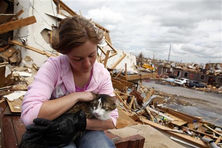 900 Pets Still Homeless After Joplin Tornado.
 It's a tragedy for people, and an equal tragedy for their pets, according to
KCCI-TV in Des Moines:
"JOPLIN, Mo. -- Hundreds of dogs and cats peer out from their cages at the Joplin Humane Society, some with cuts, infections and broken bones from the deadly tornado that turned their lives, like those of their owners, upside down.Since the tornado, the Humane Society has found itself overflowing with animals, with about 900 now calling the shelter home -- three times its usual inventory. One way or another, the pets became separated from their owners in the chaotic aftermath of the May 22 twister that tore through this town, killing 153 people. In some cases, the owners -- scrambling to find housing for themselves after 7,000 homes were destroyed, leaving nearly one-third of the city's 50,000 residents homeless -- have simply given up their pets.But the Joplin Humane Society is determined to find a home for every cat and dog. To that end, it plans an "Adopt-a-thon" the weekend of June 25-26, when animals that haven't been claimed by their owners will be given away free to good homes, after being spayed and neutered."The reality is, a lot of these people aren't in a position to come get these animals," said Joplin native Tim Rickey, a field investigator for the American Society for the Prevention of Cruelty to Animals. "They've lost everything."
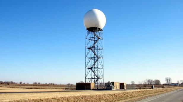
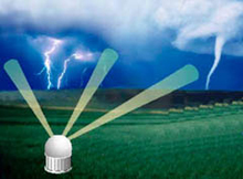
Advanced Tornado Technology Could Save Lives. The combination of next-generation Doppler radar, called "Phased Array Doppler", a new generation of weather instruments on commercial aircraft, and GPS-specific smartphones capable of alerting ONLY the people in the direct path of a tornado, may help to bring down the death toll in the years ahead.
NPR has a story about new technologies that may help: "
The CASA radars did a better job than traditional radars because they were able to provide a fresh image of the storm every minute, says Michael Zink, from the electrical and computer engineering department at the University of Massachusetts Amherst. "The problem is that with the existing system you only get five-minute updates and fast-moving weather events like tornadoes can change," Zink says. The system now used by the National Weather service consists of about 150 massive radar antennas spread across the country. They sit on dedicated towers several stories high and can track storms that are more than 100 miles away. CASA wants to augment the existing system with lots of smaller radar antennas attached to buildings or cell phone towers. These new radars would provide more frequent updates. They would also offer a better view of the part of a storm that's near the ground. Zink says you need lots of radars to do that because the radio pulses they send out travel in a straight line, rather than following the curve of the the earth. As a result, the earth blocks their view of anything that's far away and close to the ground. "So roughly 75 percent of the atmosphere below one kilometer are not covered by these radars," Zink says. "And that's an area where a lot of the weather is happening." The CASA system uses so many radars that it wouldn't have that blind spot, he says. And that could help give people a few extra minutes notice that a tornado is coming."
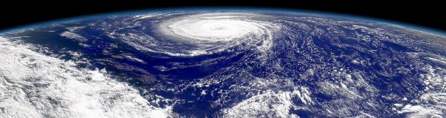
Here Comes Hurricane Season. What, you don't read Insurance Networking News? Here's an interesting story on what may be a very active year for hurricanes in the USA. Last year we lucked out as a nation: 3rd most hurricanes in the Atlantic basin in history, yet they all veered out to sea; no direct strikes on the U.S. mainland. I have a hunch the law of averages will catch up to us this season. The full article is
here: "
Catastrophe modeling firm EQECAT has issued its first “CatWatch” of the year. The publication notes the Atlantic Hurricane season is forecasted to be “slightly above average” in activity, intensity and landfalls. The firms notes that the North Atlantic Hurricane basin exhibits a characteristic ‘season,’ with 97% of historic landfalls occurring between June 1 and November 15 and the most damaging and dangerous hurricanes, with categories 3 and higher, likely to occur from August through October. Current predictions vary with the National Oceanic and Atmospheric Administration (NOAA) Climate Prediction Center (CPC) expecting six to 10 hurricanes this year, with three to six being major hurricanes (category 3, 4 or 5) compared to a seasonal average of six hurricanes and two major hurricanes. Elsewhere, the Colorado State Forecast (Klotzbach/Gray) forecasts nine hurricanes, five major hurricanes and the Tropical Storm Risk 2011 Forecast forecasts eight hurricanes, four major hurricanes. In any of these projected storms make landfall, the implications for the insurance industry may be severe. Last month, CoreLogic, a Santa Ana, Calif.-based provider of geospatial and property information services, relased the "2011 CoreLogic Storm Surge Report." The study estimated that more than $300 billion in residential property in 10 major U.S. cities is vulnerable to storm surge."
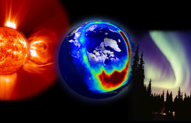
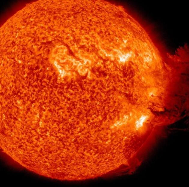
How's The Weather? Seemingly subtle changes on the sun can have a significant impact here on Earth, as described in this
New York Times Op-Ed: "
LATELY, the Sun has been behaving a bit strangely. In 2008 and 2009, it showed the least surface activity in nearly a century. Solar flare activity stopped cold and weeks and months went by without any sunspots, or areas of intense magnetism. Quiet spells are normal for the Sun, but researchers alive today had never seen anything like that two-year hibernation. Now that the Sun is approaching the peak of its magnetic cycle, when solar storms — blasts of electrically charged magnetic clouds — are most likely to occur, no one can predict how it will behave. Will solar activity continue to be sluggish, or will solar storms rage with renewed vigor? Luckily, policy makers are paying attention to space weather. Late last month, President Obama and the British prime minister David Cameron announced that the United States and Britain will work together to create “a fully operational global space weather warning system.” And just last week, the United Nations pledged to upgrade its space weather forecasts. But most people have never heard of space weather, which is a problem, because both high and low solar activity have serious effects on life on Earth."
U.S. Government In Cyber-Fight, But Can't Keep Up. I know - it's less distressing trolling for updates at TMZ.com, but in the spirit of full disclosure, here is a story that's keeping a lot of cyber-geeks (the guys wearing the white hats) up at night, as reported by
Reuters and Huffington Post: "
WASHINGTON (Reuters) - The Pentagon is about to roll out an expanded effort to safeguard its contractors from hackers and is building a virtual firing range in cyberspace to test new technologies, according to officials familiar with the plans, as a recent wave of cyber attacks boosts concerns about U.S. vulnerability to digital warfare. The twin efforts show how President Barack Obama's administration is racing on multiple fronts to plug the holes in U.S. cyber defenses. Notwithstanding the military's efforts, however, the overall gap appears to be widening, as adversaries and criminals move faster than government and corporations, and technologies such as mobile applications for smart phones proliferate more rapidly than policymakers can respond, officials and analysts said. A Reuters examination of American cyber readiness produced the following findings:
* Spin-offs of the malicious code dubbed "agent.btz" used to attack the military's U.S. Central Command in 2008 are still roiling U.S. networks today. People inside and outside the U.S. government strongly suspect Russia was behind the attack, which was the most significant known breach of military networks."
Dot Panoramic Lens Shoots 360-Degree iPhone Videos. Looking for some cool, new ways to put your iPhone to good use?
Gizmag.com has a story about a new lens for the iPhone that permits 360-degree panorama video production: "
Not long ago, we reported on the GoPano micro panoramic lens, that allows users to shoot interactive 360-degree videos on their iPhones. Well, perhaps not surprisingly, it's got some competition. Kogeto's Dot lens also lets iPhone 4 users shoot videos "in the round," although in a different configuration. Panoramic video, for those who aren't familiar with it, is actually pretty neat. The camera records everything that's visible within a horizontal loop around itself, a portion of which is displayed on the computer screen upon playback. To see what they're missing, viewers can pan 360 degrees within that loop, as they're watching the video. This means that the same footage could be watched many times, with new surprises showing up every time, depending on what the viewer chooses to look at. More advanced systems are also able to take in what's above the camera, as seen in the video for Professor Green's song Coming to Get Me."
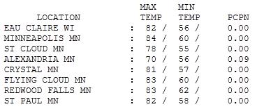 Friday: Calm Before The Storm(s)
. The sun was out for a few hours yesterday, enough blue sky for
78 at St. Cloud, a muggy 83 at Redwood Falls and 84 in the Twin Cities. Alexandria picked up .09" as of 7 pm Friday evening.
Paul's SC Times Outlook for St. Cloud and all of central Minnesota:
TODAY: Warm, with tropical humidity. Becoming partly sunny with more scattered T-storms. Winds: SE 7-12. High: 82
SATURDAY NIGHT: A few scattered showers and storms. Low: 65
SUNDAY: Partly sunny, less humid sun, with a risk of a shower or T-shower (better chance of rain east of St Cloud from the Twin Cities into Wisconsin). Winds: NE 8-13. High: 79
MONDAY: More showers & T-storms, locally heavy rain possible. Low: 64. High: 79
TUESDAY: T-storms, possible severe storm outbreak? Low: 65. High: near 80
WEDNESDAY: Storm aloft, more heavy showers - turning cooler. Low: 60. High: 72
THURSDAY: Sunshine returns - finally! Low: 54. High: 75
FRIDAY: Blue sky, a fine summer day. Low: 57. High: near 80
Tornado Tech
America has already endured 8 separate billion-dollar weather disasters in 2011; $32 billion in damage from tornadoes & flooding alone. A vast heat wave & drought gripping the south is sparking a flurry of wildfires from Arizona to Florida. La Nina has faded; scientists are scratching their heads, trying to come up with a logical explanation for the recent spate of weather convulsions.
New technology may help: experimental "phased array" Doppler uses far more (smaller) antennas, scanning the atmosphere every minute, instead of the current 5 minute lag from the 150 NWS Doppler radars. In addition, weather instruments mounted on commercial aircraft, more frequent weather balloon launches, and new smartphone apps that alert only the people in the path of severe weather, may help lower the death toll.
It's a weekend (in theory) and that means multi-colored blobs on Doppler! A nagging storm aloft will spark a few hours of showers and T-storms later today. Slightly cooler, less humid air pushes into town Sunday; a clearing trend over western and parts of central Minnesota, but showers/T-storms linger over eastern MN, including the Twin Cities as the front slows down and stalls close to home. Great timing, I know. Again, St. Cloud weather should be better (sunnier/drier) than Twin Cities weather - the farther west you travel across Minnesota this weekend the lower the risk of bumping into a downpour.
The weather map still looks like early May; the next (even stronger) storm may spark a widespread severe storm outbreak by Monday-Tuesday of next week.
Global Warming Is Burning Down The American West. Here's a story from
Salon and
TomDispatch.com: "
Arizona is burning. Texas, too. New Mexico is next. If you need a grim reminder that an already arid West is burning up and blowing away, here it is. As I write this, more than 700 square miles of Arizona and more than 4,300 square miles of Texas have been swept by monster wildfires. Consider those massive columns of acrid smoke drifting eastward as a kind of smoke signal warning us that a globally warming world is not a matter of some future worst-case scenario. It's happening right here, right now. Air tankers have been dropping fire retardant on what is being called the Wallow fire in Arizona and firefighting crews have been mobilized from across the West, but the fire remained "zero contained" for most of last week and only 18 percent so early in the new week, too big to touch with mere human tools like hoses, shovels, saws, and bulldozers. Walls of flame 100 feet high rolled over the land like a tsunami from Hades. The heat from such a fire is so intense and immense that it can create small tornadoes of red embers that cannot be knocked down and smothered by water or chemicals. These are not your grandfather's forest fires.
Because the burn area in eastern Arizona is sparsely populated, damage to property so far has been minimal compared to, say, wildfire destruction in California, where the interface of civilization and wilderness is growing ever more crowded. However, the devastation to life in the fire zone, from microbiotic communities that hold soil and crucial nutrients in place to more popular species like deer, elk, bear, fish, and birds -- already hard-pressed to cope with the rapidity of climate change -- will be catastrophic."
Mini-Ice Age: Sunspot Cycle Won't Counteract Global Warming. The
International Business Times has the story: "
Environmentalists be damned, rather than a future so hot and humid that humans will not be able to survive, the Earth is actually heading towards a 'mini ice age', according to the world's newspapers. Which just goes to show that you shouldn't read today's papers. "We have not predicted a Little Ice Age," Frank Hill of the National Solar Observatory told Reuters. "We have predicted something going on with the Sun." There's a key difference. This is certainly the view of Michael Marshall who, writing in the New Scientist, has been quick to refute the claims of a global cooling event. "The reality is that, while the sun may well be about to give us a shove in the direction of cool temperatures, the evidence suggests it won't be anything like enough to drown out the warming effects of our greenhouse gas emissions," he said. Scientists are in no doubt that the sun has been acting oddly in recent years. Sunspot numbers ebb and flow in cycles lasting around 11 years but over the past three years, observable sunspots have been mostly missing."
Ignoring Climate Change A Risky Business For All Of Us. Here's a post from the
Sydney Morning Herald: "
HOLDING coalmining shares may be lucrative today, but will there come a time when overseas climate policies turn them into dud investments? This is just one - albeit simplistic - example of the tricky questions for investors thrown up by climate change. Unfortunately, it appears this type of debate is still being shunned by some of the world's major investment houses. Big wealth managers such as pension funds have been making supportive noises about action on climate change for years. After all, Australia's resource-heavy sharemarket means the typical super fund is exposed to a rising carbon price, here and around the world. Institutional investors also have a critical role in mobilising the $1.3 trillion in super funds under management for spending on cleaner technology. But for all the warm and fuzzy talk of sustainability, there's a yawning gap between what many big investors practise and what they preach. Not only is this a shame for the environment, it also threatens to short-change the ultimate owners of the assets. Thanks to super, that's most of us. According to an Investor Group on Climate Change report published this week, some 98 per cent of global asset owners see climate change as a material risk across their portfolios."
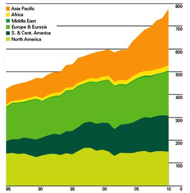
Will Alternative Energy Save Us From Peak Oil? The story from
oilprice.com: "
The people of the world are going to continue to use energy. The fundamental question that this future reality poses relates to the sources from which the energy will be produced. The vast majority of the current energy supply comes from fossil fuels, but, whether it is because of the belief that fossil fuels are going to be the cause of calamitous climate change, or because of the belief that viable production of fossil fuels cannot be sustained at increasing rate, there is a recognition that alternate and sustainable forms of energy are going to have to play an increasing role in the energy mix in that future. However the rate at which those energy supplies are brought into the mix, and the levels that they can achieve are subject to considerable discussion. The 2011 BP Statistical Review of World Energy in recognizing this, added two new sets of information to their 2011 review of fuel use around the world. The first of these documents the amount of commercial electricity that comes from renewable sources, and the second covers the amount of biofuel that is produced each year."

. Yes, this is one endorsement Mr. Romney could probably live without, although I admire his courage in stepping out and stepping up on this issue, swimming against the flow coming from the far right. The U.K.
Telegraph reports: "
Mitt Romney, the front-runner for the 2012 Republican nomination has received the kind of support he could do without – praise from Al Gore for his stance on climate change. Mr Gore, who has championed climate issues since losing the 2000 presidential race and relinquishing the vice-presidency, posted a note on his blog lauding Mr Romney for his position that mankind has contributed to rising global temperatures. "Good for Mitt Romney though we've long passed the point where weak lip-service is enough on the Climate Crisis," Mr Gore wrote. "While other Republicans are running from the truth, he is sticking to his guns in the face of the anti-science wing of the Republican Party." The message, almost certainly designed to be mischievous, could further stir up conservative criticism of the former Massachusetts governor, who outlined his position in New Hampshire. President Barack Obama and senior Democrats have also expressed enthusiasm for Mr Romney's Massachusetts health care law, describing it as a template for Mr Obama's controversial national reform of last year. Mr Romney's supporters argue that the praise from Democrats is an attempt to scupper his bid for the nomination and an indication that they fear him."


No comments:
Post a Comment