.68" rain fell yesterday in St. Cloud.
Upper 50s: dew points drop off into the 50s today, a noticeable dip in humidity.
Thursday night: next chance of showers/T-storms.

"Haboob" Invades Phoenix. Details on the fast-moving, 70-mph sandstorm that swept into Phoenix Tuesday evening below.
1,500 lives lost annually every year in the USA, due to excessive heat, by far the #1 weather killer, according to NOAA.
- Long Beach, CA: 90 (tie) Old record: 90 in 1992
- Camarillo, CA: 85 Old record: 83 in 1981
- Oakland, CA: 84 Old record: 80 in 1953

Weather "Iffy" For Friday's (Final) Launch Of The Space Shuttle. T-storms have been rumbling across Florida the past few days - there may not be a significant break in the pattern between now and Friday. More details:
- NASA is counting down toward launch the agency's final space shuttle mission on Friday, but Mother Nature may not cooperate.
- The countdown began Tuesday afternoon and is ticking down to a planned zero at 11:26 a.m. EDT on Friday, but NASA is keeping a close eye on the weather.
- Forecasts call for a chance of rain and thunderstorms on Friday, meaning that shuttle Atlantis' final mission — the last ever for NASA's iconic shuttle program after 30 years of spaceflight — might be delayed.
- 60 percent chance of weather prohibiting launch due to the potential for showers and isolated thunderstorms in the area.
- If bad weather scrubs Friday's launch, other windows open up Saturday morning and Sunday morning. And the outlook improves a bit each day, with the chance of weather problems dropping to 40 percent on Saturday and 30 percent on Sunday.
- NASA expects between 500,000 and 750,000 people to show up.
- Atlantis' STS-135 mission is slated to last 12 days to deliver supplies and spare parts to the International Space Stastion.
- NASA will retire its three-shuttle fleet for good to make way for a new program aimed at deep space exploration. The space agency aims to send astronauts to an asteroid by 2025 and then on to Mars by the mid-2030s
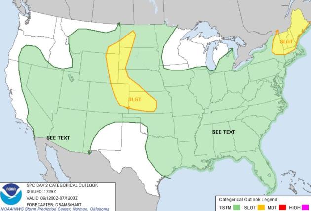
Wednesday Severe Risk. SPC has two potential trouble-spots today: severe storms from the Black Hills of South Dakota southward to Colorado's Front Range, a second area of potentially severe storms over New England.
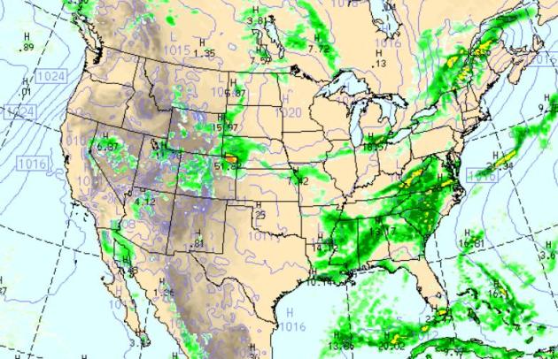
Wednesday Rainfall Potential. A bubble of high pressure keeps Minnesota, Wisconsin and the Chicago area bright and sunny (with lower humidity). Showers and T-storms are likely from the Virginias southward to the Gulf - a brief break in the action over Florida, dry from Texas into much of the southwestern USA, sunshine the rule all up and down the west coast. WRF model map above valid 1 pm Wednesday.
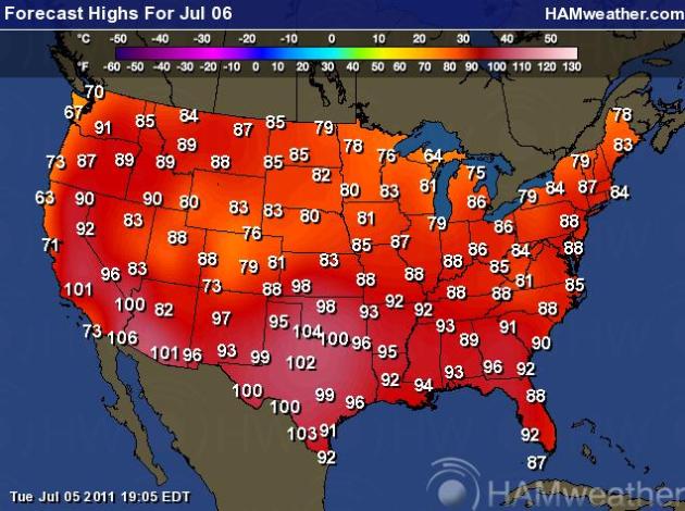
Wednesday Highs. Triple-digit heat continues today, 100s from Texas and Oklahoma westward to southern California. A drop in temperature and humidity is likely from the Twin Cities to Chicago and much of Lower Michigan.
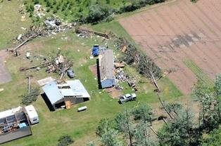
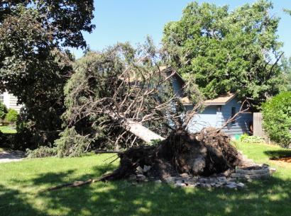
Friday "Downburst" In St. Cloud. A downburst is a violent thunderstorm downdraft reaching the ground, rain and hail-cooled air hitting the surface and spreading out, producing strong/damaging straight-line winds. Here's a good storm summary from the National Weather Service:
"Most damage was north of downtown St Cloud and was spread over several square miles. it extended into Benton County. Downburst maximum wind speed: 65 to 70 mph. Downburst damage: Hundreds of trees were toppled, broken or pushed over. Many trees landed on houses, sheds and vehicles. The downburst damage was far more widespread and significant than the tornado damage. Downburst notes: it is likely that the downburst lasted for many minutes in some areas. Other damage: There was sporadic tree damage from Rockville to St Cloud. This was much less concentrated than the Waite Park tornado damage or the St Cloud downburst damage."
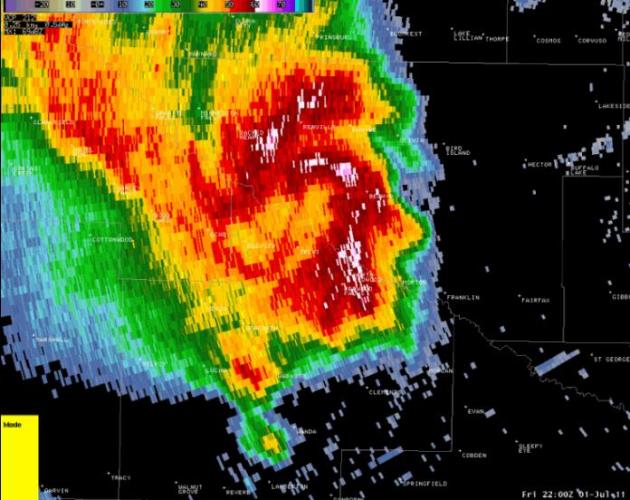
Friday Evening Tornadoes In Minnesota. The Chanhassen office of the National Weather Service has more details on the (small) tornadoes (EF-0 and EF-1) that touched down from near Redwood Falls, Vesta and Danube to St. Cloud. The image above is the a NWS image showing the "supercell" thunderstorm that dropped a couple of small tornadoes near Redwood Falls - the same cell tracked northeastward, producing a downburst in the St. Cloud area.
PUBLIC INFORMATION STATEMENT
NATIONAL WEATHER SERVICE TWIN CITIES/CHANHASSEN MN
105 PM CDT TUE JUL 5 2011

...PRELIMINARY STORM DAMAGE SURVEY RESULTS FROM KANDIYOHI...
MEEKER...REDWOOD...RENVILLE...AND YELLOW MEDICINE COUNTIES...

A NATIONAL WEATHER SERVICE STORM DAMAGE ASSESSMENT TEAM CONDUCTED A
SURVEY OF THE DAMAGE CAUSED BY THE JULY 1ST STORMS IN PORTIONS OF
SOUTHWEST AND CENTRAL MINNESOTA. THIS WAS A SMALL SEGMENT OF A
LONG-LASTING DAMAGING WIND EVENT THAT MOVED FROM NEAR THE SOUTH
DAKOTA/ MINNESOTA BORDER INTO NORTHWEST WISCONSIN. THE FOLLOWING IS
A SUMMARY OF THE RESULTS FROM THE DAMAGE SURVEY IN KANDIYOHI...
MEEKER...REDWOOD...RENVILLE...AND YELLOW MEDICINE COUNTIES.

..................................................................

WIDESPREAD WIND DAMAGE ACROSS THE COUNTIES...

EVENT...SEVERE THUNDERSTORM WINDS.

WIND SPEEDS...70-90 MPH WITH ISOLATED 90-100 MPH.

COMMUNITIES IMPACTED...COSMOS...DANUBE...ECHO...LAKE LILLIAN...
MILROY AND OTHERS.

TIME...APPROXIMATELY 422 TO 545 PM...WITH SOME AREAS LIKELY
EXPERIENCING SEVERE WINDS FOR 10 TO 15 MINUTES BASED ON ACCOUNTS
AND RADAR.

DAMAGE...SEVERAL HUNDRED TREES SNAPPED WITH DOZENS UPROOTED. A HIGH
PERCENTAGE OF THE GROVES OF TREES WITHIN THIS SWATH HAD AT LEAST
SOME VISIBLE DAMAGE. NUMEROUS UTILITY POLES WERE ALSO SNAPPED. LARGE
GRAIN STORAGE BINS WERE DENTED BY THE FORCE OF THE WIND...AT TIMES
COLLAPSING. SMALLER ONES WERE BLOWN FREE. THERE WAS SCATTERED DAMAGE
TO OUTBUILDINGS...INCLUDING BETTER CONSTRUCTED ONES. THERE WAS LARGE
ACREAGE OF CROPS SMASHED DOWN OR BENT BY THE WIND...IN SOME CASES
SHREDDED LIKELY DUE TO ACCOMPANYING HAIL.

REMARKS...THE SEVERE WIND DAMAGE BEGAN ACROSS FAR EASTERN SOUTH
DAKOTA BASED ON REPORTS AND CONTINUED MUCH FURTHER ONWARD...LIKELY
TO NORTHWEST WISCONSIN WITH NO BREAKS.
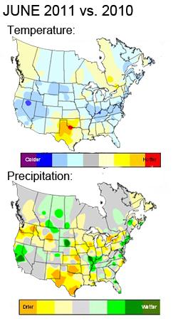
- June experienced the driest start in over 18 years on the heels of a warm Memorial Day weekend.
- A significant warm up occurred in week 2; it was the warmest 2nd week of June in 4 years with over 1,500 temperature records set this week as a heat wave gripped major markets in the Northeast & Midwest. It was also the driest week 2 of June since 2007.
- Week 3 experienced regional trends with markets in the North and East trending cooler to LY, while those in the Southern Tier continued to swelter.
- Week 4 was the coolest since 2004, although markets in the Southern Tier continued to experience triple-digit heat indices.
- The month ended with the run-up to July 4th & Canada Day, the warmest final week of June in 5 years, and driest in 10 years.
- Severe weather continued in June. Despite a drop off in incidents from May, major events in June included tornadoes in Chicago and continued flooding along the Missouri and Mississippi rivers... click for full report
- For the month, temperatures were well above normal, although cooler than 2010.
- The South Central region reported its warmest June in over 50 years.
- Dallas, Houston, New Orleans and Oklahoma City each recorded their warmest June in over ... click for full report
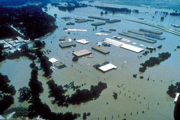
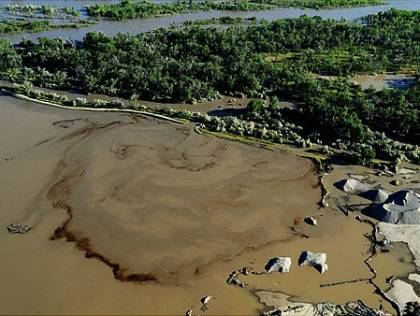
- Oil spill along the scenic Yellowstone River have been hampered by flooding and swift river conditions,
- Exxon said more than 280 people were now involved in the cleanup around the spill site from the Silvertip pipeline into the river near Billings, Mont.
- Estimated 1,000 barrels of oil the pipeline spilled into the river late Friday.
- The river originates in Yellowstone park, and is expected to crest until the middle of July.
- The leak from the 12-inch (30-centimeter) pipeline caused the temporary evacuation of some area residents. Local officials have said that flooding has hampered the cleanup work, and that some of the leaked oil could reach the Missouri River, of which the Yellowstone is a tributary.
- The cause of the leak is still under investigation, Exxon said.
- The Silvertip pipeline runs from Silver Tip, Mont., to Billings, and usually moves about 40,000 barrels of crude oil a day.
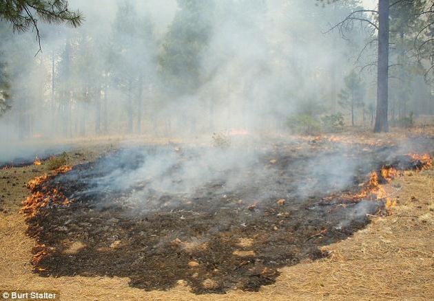
Almost $100 million has been spent in suppressing wildfires that have consumed almost 360,000 acres in the Coronado National Forest (CNF), he said.
- The largest fire in state history.
- New numbers show it has swallowed 127,821 acres. It is now 27 percent contained.
- Crews will escort residents into the Cochiti Mesa to check on their homes today. At least 45 homes burned there.
- Closer to Los Alamos crews are working on setting up a second containment line around the city.
- The fire chief said this was an immense threat to the Los Alamos National Lab and that the danger is not quite over yet as monsoons approach, which may cause flooding.
- It is still very smoky in the area, and the fire chief is urging people with breathing conditions to stay out of town.
- The Los Alamos national lab will reopen on Wednesday.
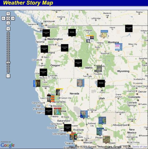
Weather Stories - Western Region. The NWS has done a spectacular job of leveraging Google base maps to present their daily "weather stories" for the western region, a good meteorological overview of what's happening in every forecast office west of the Rockies. Click on this link - then click on a specific city to see specifics.
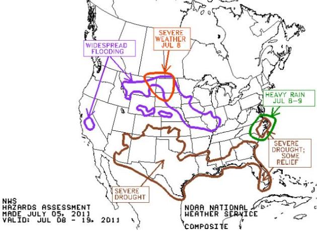
Weather Threats. According to NOAA the drought gripping much of the south will worsen through mid July, flooding forecast to continue along the Missouri River basin and the Central Valley of California. Click here to see more.
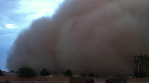
"Haboob" over Phoenix. Residents of metro Phoenix were greeted by a raging sandstorm Tuesday evening, winds gusted to 70 mph with visibilities dropping to zero in blinding sand and dust. Check out the video here, courtesy of yfrog.com.


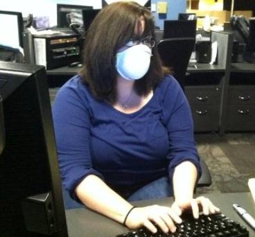
Last Week's Forecast Included Asbestos For The Weather Channel. TVNewser has the story. No, don't sweat the thundershowers - there's a 30% probability of asbestos: "Cable news channels are just like every other workplace. They are susceptible to power outages, bed bugs and yes, asbestos. Last week The Weather Channel had a close encounter with that third kind of issue in its Atlanta headquarters. Weather is in the process of redesigning its studios and content center, and as part of the process some asbestos was removed from a small section of the center that was being renovated. The smell of the solvent used to dissolve the asbestos bothered a few employees, according to a staffer. On the Facebook page for the “Abrams and Bettes” morning show, staffers had some fun, posting pictures of producers wearing face masks to minimize the smell (pictured above)."
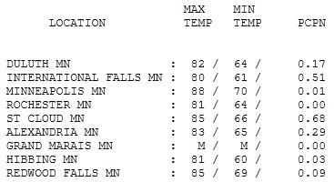
"Thunder-Sandwich." Morning showers and T-showers gave way to some afternoon sunshine, creating enough instability for a few more T-showers over the dinner hour. Highs ranged from 80 at International Falls to 85 in St. Cloud (.68" rain fell in the last 24 hours), 88 in the Twin Cities.

Paul's SC Times Outlook for St. Cloud and all of central Minnesota:
TODAY: Bright sun, lower humidity. Winds: NW 7-12. High: 82
WEDNESDAY NIGHT: Clear and pleasant. Low: 60 (upper 50s outside of town).
THURSDAY: Partly sunny, PM storms northern/western MN. High: 85
FRIDAY: Sticky sun, isolated T-storms possible. Low: 63. High: 86
SATURDAY: Hot sun, storms north/west - much of the day should be dry and lake-worthy. Low: 66. High: 86
SUNDAY: Very sticky, storms move into the metro, few hours of rain (and thunder). Low: 69 High: 87
MONDAY: More sun, storms move south of Minnesota. Low: 70. High: 89
TUESDAY: Sunny start, late-day thunder? Low: 68. High: 84

"Severe Clear"
America sees more weather than any nation on earth. Heat is the #1 killer, followed by flooding, lightning, then hurricanes & tornadoes. Out of 100 thunderstorms, fewer than 10 will turn severe (winds over 58 mph and/or 1"+ diameter hail), and only one storm will go on to spin up a tornado.
Our weather is rarely "average"; we ricochet from one extreme to the next. In 2011 the USA has seen 8 billion dollar disasters (record is 9 in all of 2008). Arizona & New Mexico have seen their largest wildfires in history, drought has turned the entire state of Texas into a disaster area; historic flooding continues on the Missouri River.
Severe weather tends to diminish the latter half of summer as the upper atmosphere warms & stabilizes (the odds of a puddle-free wedding are much higher in August than in June).
Canadian high pressure turns on comfortable sunshine today, the best day in sight. Take an extra-long lunch break outdoors. I'll write you a note. A southerly flow pumps up the humidity Thursday; the best chance of T-storms north/west of MSP. The weekend looks hot & humid, scattered T-storms likely with highs near 90. Temperatures trend warmer than average thru mid July.
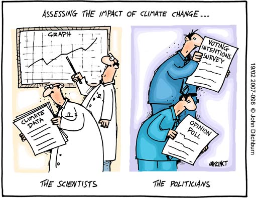
Students Try To Figure Out Our Role In Warming. Here's a story in the Star Tribune: "Wanda Shelton, 51, of Ham Lake, is highly skeptical when it comes to climate change. Even if the climate is changing, she said, it's not because of human behavior. "That takes a lot upon ourselves to think that we could change this climate by that much," she said. "I think that that's putting us above God, and I don't think we could do that." When told that according to the Proceedings of the National Academy of Science, 97 percent of U.S. climate scientists believe climate change is real and is largely man-made, she remained skeptical: "I think data can be manipulated to whatever you want to believe." It can be difficult to find solid ground in a topic awash in misconception from political slants and conflicting media coverage. While climate scientists agree that the Earth is warming unnaturally fast and that human behavior -- particularly in the release of gases like carbon dioxide from industry and cars -- is largely responsible, Americans grow increasingly skeptical. A study conducted this spring by Yale University researchers found that, since 2008, the percent of people who believe that climate change is occurring dropped from 71 percent to 64 percent. Of the people who do believe that climate change is happening, 47 percent believe it's because of human behavior, compared to 57 percent three years ago. The reasons for skepticism range from psychology to economics. An overlong winter makes it harder to believe the Earth is warming. Many people don't want to acknowledge serious impacts -- like reduced crop yields and increased flooding -- that scientists say may result from climate change. But scientists insist the problem is there."
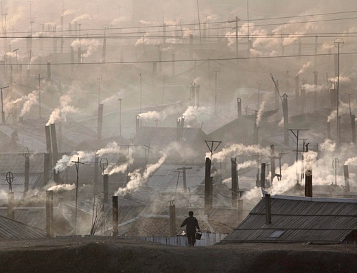
ExxonMobile Still Pays For Climate Confusion. Triplepundit.com has the story: "Despite the overwhelming consensus of scientists, a recent Gallup poll found that 43 percent of Americans still believe that global warming is caused by natural conditions, not by the emission of greenhouse gas pollutants from human activity. For an issue of settled science, that figure is startlingly high – after all, how many people still believe that the sun revolves around the earth? – but it’s not an accident. The oil company ExxonMobil is among the corporations that have paid out millions to lobbying organizations and academics who question whether global warming is a real phenomenon, or who claim that a link between global warming and human activity has not been established.
Investing in Anti-Science
Responding to shareholder concerns at a 2008 meeting, ExxonMobil pledged to reduce its support for organizations that deny climate science. One example would be ExxonMobil’s support for The Heartland Institute, a lobbying group also known for its long time work for the tobacco industry. ExxonMobil has also been a major funder of the well known climate denier Wei Hock Soon. A new report from Greenpeace U.S.A. indicates that ExxonMobil does appear to be spending less on climate denial, though as of last year it was still devoting some funds to the effort.
Climate Denial Investment Pays Off
Reducing its investment in climate deniers may have had more to do with a sound business decision by ExxonMobil than an exercise in corporate social responsibility. The investment has already paid off in the form of increased public confusion over the reality of climate change, so there is no justification for continuing to spend money at the same rate. Compared to just three years ago the aforementioned Gallup poll found that significantly fewer people now believe that the effects of global warming have already begun, and fewer people believe that man-made pollution is the cause of global warming. More people also doubt that the effects of global warming will ever occur. The Gallup report concludes that “Americans are clearly less concerned about global warming and its effects than they were a few years ago.”
No comments:
Post a Comment