.18" rain predicted for STC today as a cooler front approaches
Low 70s: dew points reach the "oh-zone" again today.
Slight Severe Risk today, followed by sunshine and a big drop in humidity Wednesday.

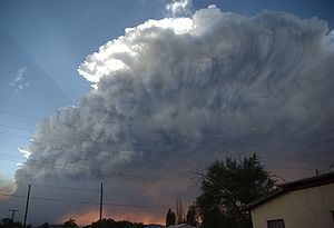
More On Friday's Severe Outbreak Across Minnesota. Possible tornadoes touched down near Redwood Falls and the St. Cloud area. The MSP NWS has more details here:
"A damage survey team was dispatched to Redwood, Yellow Medicine, and Renville Counties on Saturday. The NWS is still in the process of analyzing radar imagery and damage the survey team documented to determine if any tornadoes occurred in any of these counties on Friday. A Public Information Statement (PNS) regarding the damage will be issued once the NWS has made a final determination in what occurred in western Minnesota on Friday."
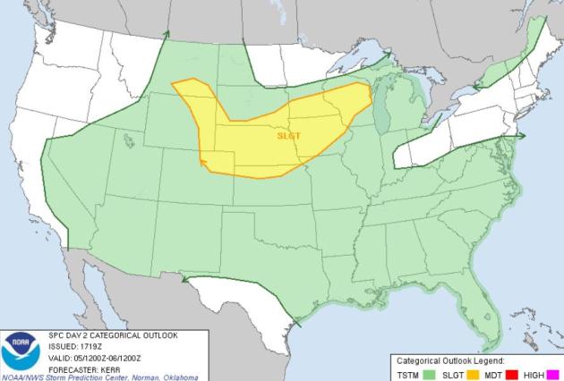
Tuesday Severe Risk. A few isolated severe storms are possible from southern Wisconsin and the southern third of Minnesota to Nebraska and Colorado/Wyoming, according to SPC.
Storm Reports On The 4th:
- 2.00” (hen egg/lime) hail in Mendenhall, Mississippi
- 1.75” (golf ball) hail in Cambridge, Maine
- 1.75” (golf ball) hail in Ripley, Maine
- 1.75” (golf ball) hail near Stewartsville, Virginia
- 1.75” (golf ball) hail in King, North Carolina
- 1.75” (golf ball) hail near Amelia Court House (actual town name), Virginia
- 1.75” (golf ball) hail near Euclid, Minnesota
- 75 mph wind gust in Roanoke, Virginia
- 67 mph wind gust in Birmingham, Alabama
- 67 mph wind gust near Vincent, Minnesota
- 65 mph wind gust near Amity, Arkansas
- 65 mph gust in Mill Creek, Oklahoma
- Roof blown off manufactured home near South Tucson, Arizona
- Mobile home blown over in Fayetteville, Tennessee
- Barn roof damage near Arab, Alabama
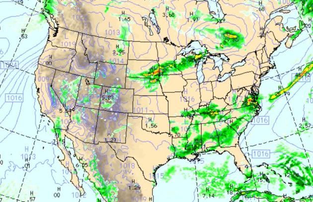
Tuesday Rain Prediction. The latest WRF/NAMmodel shows a line of strong/severe storms from Green Bay to the Twin Cities to Sioux Falls, South Dakota. Scattered storms may flare up from the Tennessee Valley southward to Macon and New Orleans, while the west stays dry.

Earth Was Farthest From The Sun Yesterday:
- At about 11 a.m. EDT Monday, the Earth reached that point in its orbit where it is farthest from the sun. Called aphelion, this location in Earth's orbit puts the planet about 94.5 million miles from the sun. That's about 3.1 million miles more than the Earth's closest distance to the sun (called perihelion), which occurred on Jan. 3.
- The exact difference in the distance between Earth's closest and farthest points from the sun is 3,104,641 miles, or 3.28 percent, which makes a difference in radiant heat received by the planet of nearly 7 percent.
- But our warm weather doesn’t relate to our distance from the sun. It's because of the 23.5-degree tilt of the Earth's axis that the sun is above the horizon for different lengths of time at different seasons. The tilt determines whether the sun's rays strike us at a low angle or more directly.
Record Heat On Monday:
- McAlester, OK: 102 (tie) Old record: 102 in 1957
- Raleigh-Durham Int’l Airport, NC: 99 (tie) Old record: 99 in 2002
- New Bern, NC: 94 (tie) Old record: 94 in 1993
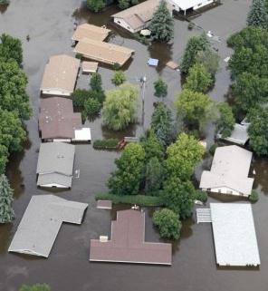
Widening Missouri River, Reducing Risk, Key To Flood Control. Stltoday.com has a story focused on potentially alleviating future flooding on the Missouri River: "From his fourth-floor cubicle next to the U.S. Army Corps of Engineers' emergency operations center in downtown St. Louis, engineer Matt Hunn keeps an eye on the Missouri River. Using graphs, maps, phone and email, Mr. Hunn serves as one of the region's chief flood fighters. Lately, he's been busy. Every day, he and numerous other state and federal officials from several agencies map out a plan to fight what is quickly becoming the historic flood of 2011. Just don't call it the "Great Flood," Mr. Hunn said. "There's nothing great about it." To engineers like Mr. Hunn, floods provide an important data point. Each one is different from the last, responding to constantly changing variables. Some are out of our control; others are not. After the 1993 flood that wreaked havoc in this region, Mr. Hunn remembered a great hue and cry for better flood-control measures across the Missouri River basin. But the energy dissipated as the water receded. "From my perspective, you've got a two- to four-year window," Mr. Hunn said. "People forget."

Deadly Storms Blast Through D.C. Metro, Mid Atlantic. AccuWeather has the story: "Strong thunderstorms, complete with driving downpours and strong winds, tore across parts of the mid-Atlantic on Sunday, killing one and injuring a few others. A bicyclist was killed on Sunday evening in Montgomery County, Md., when a tree knocked over by strong thunderstorms winds struck him. The man was pronounced dead on the scene a short time later. The same storm later hit downtown Washington, D.C., forcing people rehearsing for today's Capitol Fourth concert to evacuate, according to Capitol Police. Private weather stations around D.C. reported wind gusts of 60 to more than 70 mph as the storms moved through, accompanied by torrential downpours and frequent flashes of lightning. Numerous trees were downed throughout the city, including on the West Lawn of the Capitol. Forty thousand people across northern Virginia, D.C., and nearby parts of Maryland lost power at the height of the storm."
- A strong storm that moved through the Roanoke (Virginia) Valley Monday afternoon knocked out power to thousands of people and led to reports of damage across the valley.
- At Roanoke Regional Airport, emergency crews were investigating reports of damage to several planes. One private plane had been flipped onto its nose, but no one was injured.
- Monday's storms damaged Northside Middle School's roof. Ceiling tiles on the school's second floor caved in, and there is water damage on the first and second floors.
- More than 12,000 customers reported being without power.
- 75 mph wind gust reported in Roanoke.

Massive Thunderstorm Rips Through Las Vegas. KLAS-TV hast the story: "LAS VEGAS -- A huge thunderstorm ripped through Las Vegas Sunday afternoon, downing trees and causing flooding all over town. A Flash Flood Warning was issued earlier in the day, but has since expired. NV Energy also had several people without power. The company reports 10,000 customers are without power. The outages are spread across the valley and crews are working to restore power. The storms moved in from the south and caught many people by surprise. High winds downed trees around the valley and roads were flooded. Firefighters were even called to conduct a swift water rescue near Flamingo and Paradise Roads."
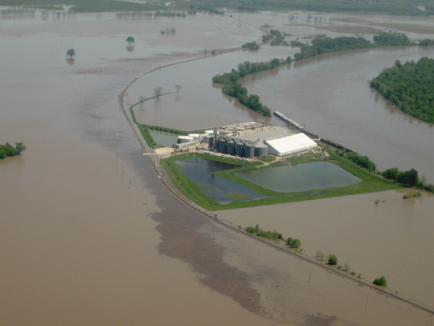
Flood Problems Will Increase Stress For People. Yes, this may be the biggest duh-headline I've seen lately. Talk about stating the obvious. More from the Chicago Tribune and AP: "LINCOLN, Neb.— Flooding along the Missouri River is expected to continue until at least August, but the emotional stress from dealing with the flooding could last even longer. University of Nebraska-Lincoln Extension educator LaDonna Werth says people who experience losses in the flooding should talk about their feelings with friends, family and neighbors. Children might especially need help to regain a sense of security. Or they have trouble dealing with having to throw away belongings damaged by the flood. Couples who are facing loss may find that each spouse copes differently with the stress. Werth says the important thing is to keep talking things over and to show love toward each other."
Despite Progress, Huge Fire Near Los Alamos Mostly Out Of Control. WMTW-TV and CNN have an update on the largest wildfire in New Mexico history: "(CNN) -- Despite relatively favorable conditions and some progress, a massive wildfire continued to burn Sunday night in northern New Mexico -- threatening national forests, archaeological sites and structures while causing air quality problems around the state.The Las Conchas fire scorched more than 120,000 acres and destroyed more than 100 buildings by late Sunday, the federal Incident Management Team reported on its website.The damage has occurred in the span of one week, with New Mexico State Forester Tony Delfin announcing Sunday night that it began June 26 when strong winds knocked down an aspen tree. The tree caught fire after falling on a nearby power line, then hit the ground and sparked nearby vegetation.Brad Pitassi, an Incident Management Team spokesman for the Southwest, stressed that the fire remains "very active," as it was only 19% contained by Sunday night."
- Even as Los Alamos, NM residents settle in back at home, it is no holiday for those fighting the Las Conchas fire.
- The largest fire in state history.
- New numbers show it has swallowed more than 123,000 acres. It is now 19 percent contained.
- Crews will escort residents into the Cochiti Mesa to check on their homes on Tuesday. At least 45 homes burned there.
- Closer to Los Alamos crews are working on setting up a second containment line around the city.
- The fire chief said this was an immense threat to the Los Alamos National Lab and that the danger is not quite over yet as monsoons approach, which may cause flooding.
- It is still very smoky in the area, and the fire chief is urging people with breathing conditions to stay out town.
- The Los Alamos national lab will reopen on Wednesday.
To the Meteorologically Insane...
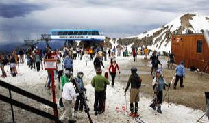
Snowbird Caps Longest Season With Holiday Skiing. The Deseret News has the eye-opening details. Nothing more patriotic than skiing on Independence Day: "LITTLE COTTONWOOD CANYON — A few thousand mostly red-and-blue-clad skiers celebrated the Fourth of July on the white slopes at Snowbird Ski and Summer Resort. "This is unbelievable," said Salt Lake City resident Melissa Witman, who wore a red, white and blue bikini top Monday on the resort's final day of the ski season. "It's summer skiing!" Temperatures in the 50s and 60s made swimsuits and shorts popular choices for skiers who decided to take advantage of the longest ski season in Snowbird's 39-year history. "It's beautiful up here on the Fourth of July," said Clayton Butler of Salt Lake City, who wore only skis, boots, a helmet and a Speedo. "It's a little chilly if you hang out up top too long. But once you start going, it warms right up." By being open for skiing Monday, Snowbird set a record for the number of days it was able to stay open in a single season with 202, said Emily Moench, the resort's communications manager. The previous record of 201 was set in 2005. Snowbird also had a record for snowfall this season, with 783 inches — topping the previous high by nearly 100 inches, Moench said.
- Ski resorts from California to Colorado opened for the weekend to take advantage of an unusual combination of dense lingering snow from late-season storms in the Sierra Nevada and the Rockies and a high-pressure system ushering in warm air from the east.
- Resort operators were reporting large crowds, balmy temperatures and plenty of bare skin.
- California's Alpine Meadows, on Lake Tahoe, has offered Independence Day skiing just one other time in its 50-year history.
- At Snowbird Ski and Summer Resort in Utah, 783 inches of snow this season smashed the old record of 688 inches set in the winter of 1983-84. By the time the resort closes for the season after Monday's holiday, it will have been open a record 202 days.
- Colorado's Arapahoe Basin Ski Area, located 70 miles west of Denver, last offered skiing on Fourth of July weekend in 1997.
- The weather allowed some of the more adventurous skiers at Arapahoe to try "pond skimming," a blend of snow skiing and waterskiing in which an individual picks up as much speed as possible going downhill and then attempts to coast over the top of a mid-mountain lake.
- But while snow-sport enthusiasts are celebrating, the peculiar conditions are proving frustrating — and even deadly — for visitors to some of the West's popular camping and hiking destinations. This year's massive snowpack is thawing, causing rivers and streams to surge and prompting flood warnings.
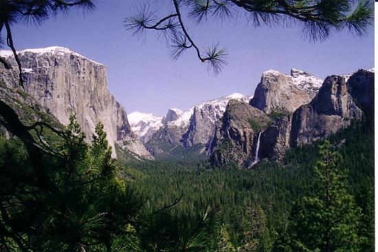
- At Yosemite National Park in California, one hiker was killed and another remained missing after they were swept off a bridge into a reservoir Wednesday by unusually high runoff. Several of the park's popular high-country campgrounds, cabins and other amenities remain closed due to snow.
- Oregon and Wyoming both saw their second-wettest spring in 117 years of record keeping as a result of late-season snowmelt and abundant rain, according to the National Climatic Data Center.

The Grand Finale. What a 4th - sunshine lingered over the southern two thirds of Minnesota, enough blue sky for mid 80s to 90 in the Twin Cities. Storms bubbled up over the Red River Valley - turning severe as they reached the Brainerd Lakes area by midnight.

Paul's SC Times Outlook for St. Cloud and all of central Minnesota:
TODAY: Sticky with some sun, PM storms, some severe? Winds: W 10-15. High: 82
TUESDAY NIGHT: T-storms, some strong/severe in the evening. Clearing late. Low: 62
WEDNESDAY: Bright sun, less humidity, a fine summer day. High: 85
THURSDAY: Partly sunny, sticky again late. Low: 66. High: 82
FRIDAY: Scattered T-storms likely. Low: 68. High: 85
SATURDAY: Partly sunny and hot. T-storms, some severe? Low: 70. High: 88
SUNDAY: Showers linger, sunnier up north. Low: 71. High: 86
MONDAY: Drier day, still quite humid. Low: 69. High: 87
Glass Half Full
Predicting weather isn't an 8 hour/day gig. You're analyzing current data (and fickle model solutions) 24/7. And Mother Nature rarely takes a vacation. It's been a mind-boggling year: floods in the north, record snows out west, historic fires & drought in the south.
Relatively speaking, Minnesota has gotten off easy. A worst-case flood scenario did not unfold in the spring, summer moisture has been more than sufficient for farmers with far fewer tornadoes than last year. The risk of a summer drought is negligible. All topped off by the most remarkable 4th of July holiday weekend anyone can remember. For 3 bright, shining days there were no wagging fingers, no "Paul, can't you DO something about this?" cracks. I was optimistic late last week but the weather turned out even better than expected. A photo-finish.
Back to reality today. The drippy dew point reaches 70, enough fuel for T-storms - a few may turn severe over the southern third of Minnesota. A surge of Canadian air drops humidity levels Wednesday, more storms returning by Friday, even a severe weather outbreak on Saturday. Skies may clear up north on Sunday - odds are next weekend won't be quite as amazing as the 4th.
Global Warming Worse Than Thought, Warm Water The Culprit. The International Business Times has more on the story that broke on Sunday - turns out warm water melts ice a lot faster than warmer air: "Global warming and the melting of the polar caps is worse than previously thought, according to a new study from the University of Arizona that appeared in Nature Geoscience. The study asserted that the culprit is warming ocean waters. "Water has a much larger heat capacity than air. If you put an ice cube in a warm room, it will melt in several hours. But if you put an ice cube in a cup of warm water, it will disappear in just minutes," said Jianjun Yin, who worked on the study. Water has the second highest specific heat capacity of all known substances. It, rather than air, holds most of the earth's global warming heat, so it makes sense that its impact on global warming is significant. The study estimates that subsurface ocean temperature along the coast of Greenland could rise by 3 degrees Fahrenheit and those along the coast of Antarctica could rise by 0.9 degrees Fahrenheit by 2100. While the study estimates that the subsurface temperatures for both poles will rise more than what the scientific community previously expected, the danger is greater for the North Pole (coast of Greenland)."
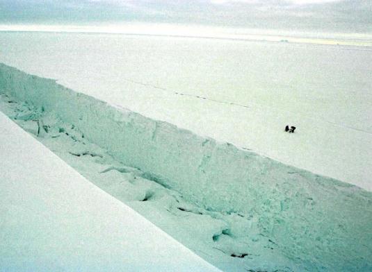
Photo Credit: (Photo: REUTERS/Greenpeace Greenpeace) Greenpeace crewmembers Andy Friemuller, from Switzerland and Marc Defourneaux, from the USA, (left & right are unidentifiable) inspect a crack in the Larsen B ice shelf indicating the continuing disintegration and melting of the ice shelf February 4. Many scientists believe that the Larsen B shelf will follow the Larsen A shelf and disappear in the next few years. Human induced Global warming is believed by many climate experts to be the cause of this breakup.

China's Imminent Collision With "Peak Coal". Business Insider has the story: "World coal production is dominated by China. China's coal production is projected to peak in 2027 with a peak production level of 5.1 billion tons. World (excluding China)'s coal production is projected to peak in 2027 with a peak production level of 4.1 billion tons. Coal is mainly used for “base load” electricity generation (to meet the part of the electricity demand that requires constant flows) and is an essential input in the iron and steel industry. In 2008, coal accounted for 22 percent of the world’s energy consumption in the industrial sector (including non-energy uses) and 4 percent of the energy consumption in the residential and commercial sector. Coal accounted for 41 percent of the world’s electricity generation (IEA 2010). In 2010, world coal production was 7,273 million tons. Figure 11 shows the annual coal production of the world’s largest five producers. The world coal production and consumption is dominated by China. In 2010, China accounted for 45 percent of the world coal production (by volume) and 48 percent of the world coal consumption (by energy content)."
No comments:
Post a Comment