76-78 F. dew point expected at STC by afternoon, winds from the southeast at 10-20.
100-105 F. heat index possible by mid afternoon in the St. Cloud metro area.
Severe storm risk today: expect watches and warnings, hail, damaging winds, even an isolated tornado can't be ruled out.
6 days above 90 so far in July in St. Cloud.
+5.5 F. So far July temperatures are running 6 degree above average at St Cloud in July, according to the MN Climate Office.
85.89 F. average high so far in July at St. Cloud.
64.4 F. average low since July 1.
55 F. dew point Sunday, HALF as much water in the air, winds from the northwest at 10-20; choppy on area lakes.
* Sunday: the sunnier, drier, nicer (far more comfortable day) of the weekend.
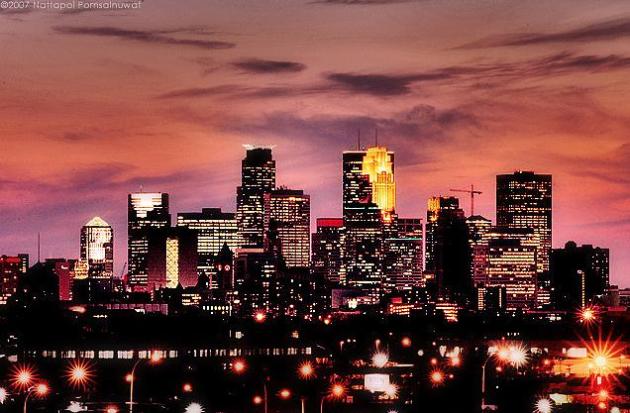
"...Preliminary data also indicate a new Heat Index record of 124 degrees F was reached in the Twin Cities on the 19th." - Dr. Mark Seeley, in this week's WeatherTalk blog post below.
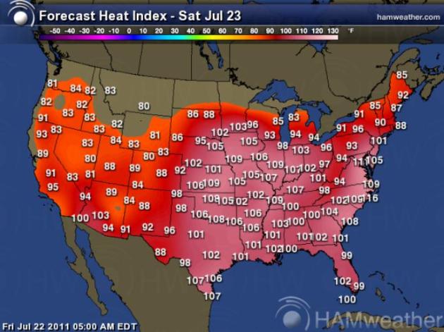
Another Sizzler. The heat index is forecast to rise above 100 again over much of the eastern 2/3rds of America, more records will fall from New York and D.C. to St. Louis. Dallas should see their 22nd day/row above 100. Map courtesy of Ham Weather.

Jungle-Like Saturday, Comfortable Sunday. With dew point temperatures expected to rise into the upper 70s to near 80, today's heat index may venture into the 105-110 range in the Twin Cities. A fresh, northwest wind (gusting to 20) will push dew points into the 50s tomorrow - no heat index to speak of. Yes, Sunday should be downright comfortable, a vague hint of September in the air.
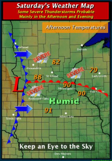
Saturday Weather Story. A lovely Saturday: jungle-like dew points and a heat index as high as 110, topped off with a few severe storms by afternoon. Something for everyone! Map and narration courtesy of the Chanhassen office of the National Weather Service:
"The threat for severe thunderstorms will increase late tonight across west central into central Minnesota, and then more so on Saturday across the entire region with the approach of a cold front. In advance, temperatures will warm on Saturday, especially across southern Minnesota. Depending on how much thunderstorm activity and cloud cover there is in the morning, temperatures on Saturday could reach the lower 90s across a large portion of the area. Heat index readings may reach up to 100° to 108°. If planning outdoor activities on Saturday afternoon and evening, remember to stay cool and to monitor the weather forecast, ensuring you have a means to be notified of a warning if one is issued."
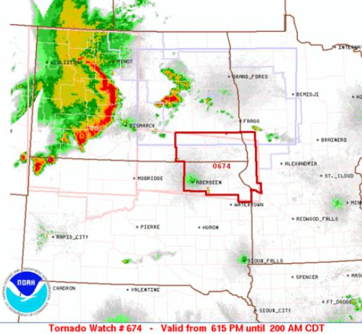
"Bow Echo." Anytime you see a boomerang-like swirl of red on Doppler you know you have potentially severe, straight-line winds on your hand. The Tornado Watch posted for extreme west central Minnesota expired at 2 am Saturday, but strong T-storms may rumble across central/northern Minnesota this morning.
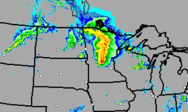
Noisy Start Up North? NOAA's HRRR model (valid 8 am this morning) shows strong to potentially severe storms over central and northern Minnesota, the best chance of hail, high winds and torrential rains north of St. Cloud.
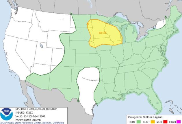
Saturday Severe Threat. Storms will be severe later today, from St. Cloud and the Twin Cities into Wisconsin, northern Iowa and the Rockford/Chicago area, cumulonimbus sprouting out ahead of a push of cooler, drier Canadian air that will drop humidity levels by Sunday across much of the Northern Plains and Upper Midwest.
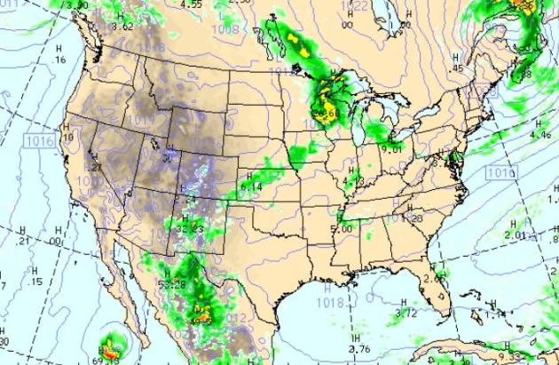
7 PM Today. Feeling lucky? Me neither. It's a big evening in the Twin Cities, U2 playing at the TCF Bank Sttadium in Minneapolis, the Aquatennial fireworks going off - the WRF/NAM model is hinting that storms may be just east of MSP by 7 pm. Personally, I wouldn't bet on it. Plan for storms, and be pleasantly surprised if it doesn't rain. Much of the nation will be dry, a few T-storms from New Mexico to Omaha, thundery weather near Detroit and Cleveland.
* Speaking of severe storms and concerts - if you're in a stadium the safest place to ride out a severe storm (or tornado) would be the interior rest rooms on the lowest floor. Do NOT try to make it to your vehicle - you're much safer riding out the storm in a structure - any structure, than a car or truck.
Friday Record Highs:
Georgetown, DE…. 103
Allentown, PA… 102
Philadelphia…102
Atlantic City, NJ… 102
Reading, PA…102
Trenton, NJ… 103
Islip, NY… 100
Kennedy, NY… 103
LaGuardia, NY… 103
Newark, NJ.. 108 (hottest ever recorded)
Central Park… 104 (second hottest ever recorded).
Washington, DC (Dulles Airport)… 102
Boston.. 103 (Tied)
Hartford… 102
* thanks to Chad Merrill from Earth Networks for passing these records along.

"Northeast Braces For Temps Near Boiling Point." O.K. This headline caught my eye. But the "boiling point"? Am I missing something here? I thought that was 212 F. If it gets that hot I'm on the next Space Shuttle to a more hospitable place, like Venus. AP has the story.
Heat Facts:
- New York: Only 57 days of 100°+ heat since 1870 at Central Park. None from '02 through June '10.
- Boston: Only 24 days of 100°+ heat on record since 1872!
- Philadelphia: Averages only 1 day of 100°+ heat every other year.
- Hottest day since Sep. 4, 1953 in Elmira, NY (104). Hottest temperature ever recorded!
- Hottest day since July 6, 1993 in Rochester, NY (98).
- Hottest day since July 14, 1995 in Toledo, OH (102), Defiance, OH (102), Lafayette, IN (101), and Detroit, MI (100)
- Only a "Dust Bowl" day was hotter in Syracuse, NY (101 Thursday...102 on July 9, 1936).
- Other 100s: Newark, NJ (103), Reading, PA (102), Lancaster, PA (100), Allentown, PA (100), Baltimore, MD (100), Indianapolis, IN (100), Ft. Wayne, IN (100).
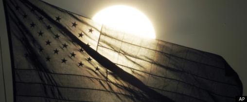
Heat Wave Bakes Eastern USA. An update from Huffington Post: "NEW YORK — Americans withered under yet another day of searing sun Friday as a heat wave spread in earnest into the urban core of the Northeast, while excessive heat warnings stretched from Kansas to Maine and the Carolinas. Temperatures were forecast near or into the triple digits Friday and into the weekend. The high temperatures and smothering humidity will force up the heat indexes. Boston's 99 degrees on Friday could feel like 105 degrees; Philadelphia's 102 degrees like 114 degrees and Washington, D.C.'s 103 degrees could seem like 116. It's enough to test the patience of a saint. Taking her morning walk with temperatures already soaring near 90, Sister Elizabeth Ann Hughes of St. Thomas Aquinas Roman Catholic Church in Philadelphia offered her simple strategy – go out only when it's relatively cool and stay in the air conditioning when it's not. "I walk in the shade and get out of the sun before 10 a.m.," she said. In New York, people looking to beat the heat were thwarted by warnings urging them to avoid city waterways after a wastewater treatment plant disabled by fire began spewing millions of gallons of raw sewage into the Hudson River." (photo above courtesy of AP).
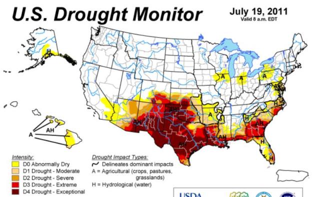
Drought Update. Map courtesy of NOAA's Drought Monitor.
- If you add up all of the land area under some sort of #drought right now in the US, it is about the area of ALL of #Mexico!
- 75% or 201,435 sq miles in Texas under Exceptional drought Area 3.5X bigger than Georgia
- Rain is helping the drought in Georgia as only 9% of the state is under exceptional drought this week, down from 35% last week. However, 95% of the state is still under some form of drought.
- Florida is under NO exceptional drought, however 90% of the state is still under some form of drought.
- 97% of South Carolina under drought
- 71% of North Carolina under drought
- 61% of Alabama under drought
- 70% of Mississippi under drought

Record-Breaking Week For Minnesota. Here's an update from Dr. Mark Seeley, an excerpt from this week's edition of "WeatherTalk": "Despite the near absence of 100 degrees F temperature readings, the period from July 16 to July 20 was one of the hottest five day periods in Minnesota history in terms of human comfort. The only weather observer to report a three-digit air temperature was Blue Earth with 102 degrees on the 20th. But some observers reported Heat Index Values of 100 degrees F or higher on five consecutive days. At Moorhead, dewpoints hit 80 degrees F or higher everyday from the 16th to the 20th, topping out at 88 degrees F on July 19th with a Heat Index of 134 degrees F, both tentatively new statewide records. The Twin Cities endured for the first time a period of three consecutive days with dewpoints hitting 80 degrees F or higher. On July 19th a new all-time dewpoint level was achieved with a reading of 82 degrees F, topped by a sub-hourly reading of 84 degrees F. These new records will have to be certified by the State Climate Office. Preliminary data also indicate a new Heat Index record of 124 degrees F was reached in the Twin Cities on the 19th. Even far northern areas reached uncharted dewpoint and Heat Index values during this period. Hallock hit a dewpoint of 84 degrees F with a Heat Index of 111 degrees F on the 19th, while Winnipeg, Manitoba (Canada) reported a dewpoint of 77 degrees F and a Heat Index of 109 degrees F, both new records. Those without air conditioning suffered as overnight low temperatures set records for warmth as well, with many observers reporting minimum temperatures that ranged from 77 degrees F to 82 degrees F. The Heat Index at midnight on July 20th in the Twin Cities was still 100 degrees F, perhaps the only time it has been so high that late at night."

Boy Sucked Up Into Tornado Tells His Story. Here's a remarkable story of survival, courtesy of KCCI-TV and KMBC-TV: "RAYMORE, Mo. -- Kaid Fidler has come a long way since a tornado sucked him out of a Joplin, Mo., restaurant cooler where he had run to take shelter, reported KMBC-TV in Kansas City. KMBC's Maria Antonia showed up recently at Kaid's home with a his Pizza Hut favorite -- stuffed-crust pepperoni. Even with metal bars still in his mouth to help with injuries to his jaw, he was able to get his fill.On May 22, Kaid, 12, was at the pizza restaurant with his grandmother and sister when the tornado hit Joplin."I thought I was going to die when I was flying around the tornado," Kaid said.Kaid suffered injuries from his head to his legs. He said he tried to take cover when the storm hit."I remember being inside the cooler and getting sucked out," Kaid said.Kaid's sister, Kristen, was there with him during the storm."It was like, all gray. I kept hitting the ground. There was a loud noise and then I blacked out," Kaid said.Kristen found her brother under one of the piles of debris and started digging him out."

During Storm Season, Families Must Protect Their Pets. Some good advice in an Op-Ed from the Winston-Salem Journal: "When I was a little girl growing up here in the South, hunkering down in the basement with my family and our pets waiting for a tornado warning to pass, I never imagined that one day I'd be in charge of an organization whose work not only protects children and animals from abuse and neglect but keeps them safe when the skies darken and the seas swell. But here I am, all these many years later, living in the Triad area, and bringing with me a top country band and an 82-foot rescue vehicle to let my friends and neighbors know that the time to think about preparing for disasters is now . During this season of storms, that means having supplies set aside and a well-defined plan in place that you've discussed with your family and emergency contacts. It also means paying particularly close attention to the special needs of the most vulnerable members of your family and our community. For children, think about all the things you'd need in case you need to leave for a week, and be ready to quickly round up car seats, medicine, treasured toys and other comfort items. Depending on your kids' ages, you may need to have special food, formula, diapers, portable cribs and other supplies set aside as well. Any parent can tell you that making it from one day to the next can be hectic enough. Don't put yourself in the position of trying to remember what to pack when the emergency sirens sound. For your animals, remember that things like pet food, litter and veterinary medicines are probably going to be harder to come by than human supplies if you have to leave your home for an extended period. Have at least a week's store, along with water, your pet carrier and feeding and waste containers ready to go."
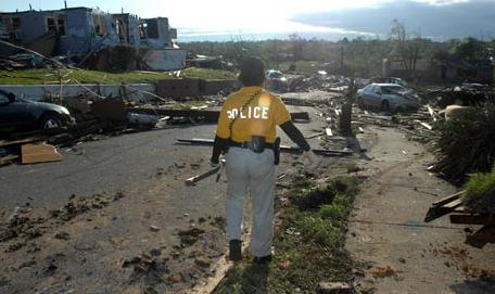
Run Of Disasters Pushes Insurer Into Red. It's turning into a very bad year for insurance companies worldwide, according to the U.K. Guardian: "Hefty disaster claims have pushed Lloyds of London insurer Beazley into the red, and left its customers facing higher insurance premiums. The insurance industry was hit by an exceptional run of natural disasters in the first six months of this year. The devastating Tohoku earthquake in Japan, another in New Zealand, floods in Australia and tornadoes in the eastern US have inflicted losses of more than $50bn (£30.6bn) on the industry. Analysts expect other insurers to report losses in coming weeks. Beazley, the first listed Lloyds insurer to report half-year results, sank to a loss before tax of $24.2m between January and June, compared with a profit of $115.5m in the same period last year. It took a $183m hit from the disasters but profits from non-catastrophe businesses allowed it to "largely absorb" the impact. US rival Travelers also slipped into the red in the second quarter. Beazley, which insures clients against the impact of natural disasters, terrorism and other eventualities, said: "We expect the aggregate effect of this sequence of catastrophes will be to increase rates for our property and reinsurance divisions. In loss-affected areas we are seeing rates harden by up to 60% in our international reinsurance portfolio, whilst in the US reinsurance rates are increasing by 5-10%."
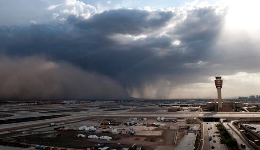
"Haboobs" Stir Critics In Arizona. Are you serious? This is like a bad episode of The Simpsons. "Haboob" is an Arabic term - since these storms are carbon-copies of the massive sandstorms that whip up from Iraq to the Sahara Desert. But using the correct, meteorological term (apparently) offends some people. Good grief, don't we have enough to worry about without calling in the Word Police? The New York Times reports: "PHOENIX — The massive dust storms that swept through central Arizona this month have stirred up not just clouds of sand but a debate over what to call them. The blinding waves of brown particles, the most recent of which hit Phoenix on Monday, are caused by thunderstorms that emit gusts of wind, roiling the desert landscape. Use of the term “haboob,” which is what such storms have long been called in the Middle East, has rubbed some Arizona residents the wrong way. “I am insulted that local TV news crews are now calling this kind of storm a haboob,” Don Yonts, a resident of Gilbert, Ariz., wrote to The Arizona Republic after a particularly fierce, mile-high dust storm swept through the state on July 5. “How do they think our soldiers feel coming back to Arizona and hearing some Middle Eastern term?” Diane Robinson of Wickenburg, Ariz., agreed, saying the state’s dust storms are unique and ought to be labeled as such. “Excuse me, Mr. Weatherman!” she said in a letter to the editor. “Who gave you the right to use the word ‘haboob’ in describing our recent dust storm? While you may think there are similarities, don’t forget that in these parts our dust is mixed with the whoop of the Indian’s dance, the progression of the cattle herd and warning of the rattlesnake as it lifts its head to strike.”

Redneck Refrigerator. No, please don't try this at home, no matter what the heat index is. Good grief. Come to think of it I wonder if I could fit in there? Thanks to verydemotivational.com for passing this along...
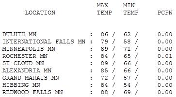
Increasingly Sticky. Friday wasn't a bad day, all things considered. It was downright comfortable up north (50-degree dew points over the Arrowhead), but by evening dew points had risen into the low 70s over central and southern Minnesota, back up into the tropical range. Highs ranged from 72 at Grand Marais to 89 at St. Cloud and the Twin Cities.
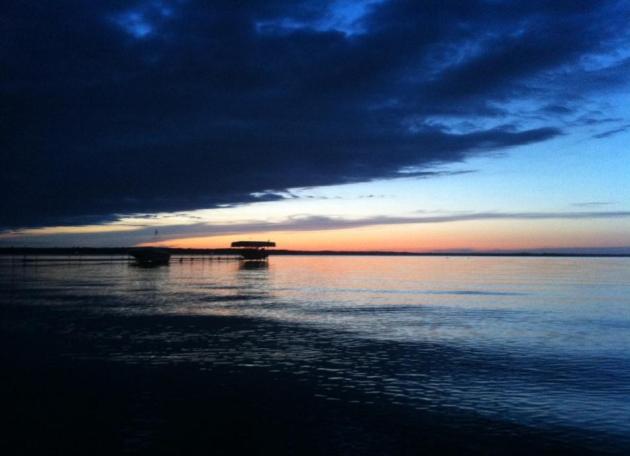
Paul's SC Times Outlook for St. Cloud and all of central Minnesota:
TODAY: Oppressively humid with some morning/midday sun. DP: 77. Severe storm risk morning, again mid afternoon. Winds: S 10-20. High: 87
SATURDAY NIGHT: T-storms, some severe evening hours. Locally heavy rain. Cooler late. Low: 66
SUNDAY: Nicer day of the weekend with plenty of sun, a HUGE drop in humidity. Comfortable breeze! DP: 53. Winds: NW 15-20 (chopping on area lakes). High: 79
MONDAY: Partly sunny, late storms far western MN. Low: 61. High: 84
TUESDAY: Hot and sticky again, few more T-storms. Low: 68. High: near 90
WEDNESDAY: Steamy, strong T-storms in town. Low: 71. High: 91
THURSDAY: Lingering showers, T-storms - humid. Low: 74. High: 87
FRIDAY: More sun, turning less humid. Low: 70. High: 86


What Can Go Wrong?
My nervous twitch is back. 58,000 screaming U2 fans at TCF Bank Stadium in Minneapolis this evening, a few hundred thousand people gawking at Aquatennial fireworks tonight. That's a pretty sweet target for Mother Nature. Jungle-like dew points (close to 80) should provide enough fuel for strong to potentially severe storms, best chance (of course!) coming during the evening hours, when the atmosphere is most unstable & irritable. The dreaded heat index (a liberal conspiracy, according to Rush Limbaugh) may hit 105, before T-storms rumble into town.
It's been an historic week: a record-smashing 88 dew point and 134 F. HI at Moorhead Tuesday. According to Dr. Mark Seeley - the Twin Cities saw 3 days/row with a dew point above 80. That's never happened before. Could be worse though. According to Jeff Masters, Chief Meteorologist at Weather Underground, the country of Oman set an all-time (global) record for the warmest nighttime "low" ever observed: 107 F. Insert exclamation point here.
A cooler front sweeps humidity and stormy stragglers towards Chicago tomorrow, a fresh northwest wind gusting to 20 (a little chop on your favorite lake). But we'll all be breathing a lot easier as dew points drop into the 50s, HALF as much water in the air. Good timing.
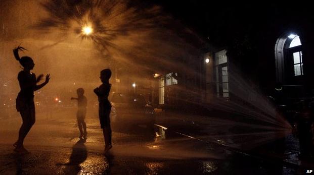
U.S. Heatwave Raises Climate Complexity. The BBC takes a look at attitudes on climate change in the USA, in light of the current heatwave (which is weather, not climate, btw): "In the last couple of Northern Hemisphere winters, with temperatures plummeting across tracts of North America and western Europe, "belief" in man-made global warming - it was widely reported - took a bit of a dip. As to why that might be, there was no hard evidence - but plenty of the anecdotal stuff around in comments on blog posts, and from callers to phone-in programmes, suggested the weather was indeed an issue. A recent opinion survey in the US produced an intriguing and somewhat perplexing insight into all this. The Climate Communication programmes at Yale and George Mason Universities asked people whether their views on the issue were affected by weather extremes. About half either "strongly agreed" or "somewhat agreed" that cold snaps had made them question their belief in global warming, while a similar proportion said heatwaves had strengthened their belief." (photo above courtesy of the AP).
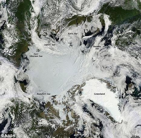
Global Warming On Target To Melt A Record Amount Of Ice In 2011. The U.K. Guardian newspaper has the very latest; here's an excerpt:
"Global warming fears were heightened today as it emerged that the Arctic is facing record levels of melting ice this year. A warm spell gripping the region has melted a staggering 46,000 square miles of ice each day so far in July. The vast amount is the same area as the state of Pennsylvania being lost every day, according to the National Snow and Ice Data Center (NSIDC) in Boulder, Colorado. On July 17 this year, sea ice covered 2.92million square miles of the Arctic Ocean. The amount of ice cover is currently 865,000 square miles below the 1979 to 2000 average. The previous fastest rate of melting ice was in 2007. Researchers said that the melting and re-freezing of Arctic sea ice takes place with varying intensity each year."
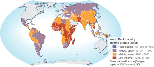
Global Warming Will Compel Nations To Spend More On Environment. The Economic Times of India has the story: "In the coming years, global warming will compel both developed and developing nations to spend more on environment protection. The World Bank estimates the cost of keeping global warming down to 2 degree centigrade will cost $140 billion-$675 billion a year in developing countries. The UNDP's Human Development Report 2007 says a temperature rise from 3-4 degree celsius would displace 340 million people through flooding and drought. Besides, retreating glaciers would cut off drinking water from as many as 1.8 billion people. The global economy will face a more severe downturn than the current crisis if it fails to halt climate change, said Nicholas Stern , one of the leading environmental economists. If green economic policy becomes a reality, it would brighten India's scope of exporting a wide range of biodegradable handicraft items." (map courtesy of mappery.com)
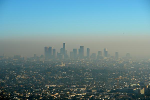
Global Warming Slowed By Aerosols. An update from the Sydney Morning Herald: "FOR many years, people have thought of aerosol cans as being bad for the environment but it seems aerosols - tiny, airborne particles - have slowed the rise in global temperatures over the past decade. American researchers have measured the effect aerosols in the upper atmosphere have had on climate change, building on past research that has identified the temporary cooling effect of these molecules in other parts of the atmosphere. The researchers believe the increase in aerosols comes from coal-fired power stations in developing countries, many of whom do not require their power stations to contain their sulphate emissions. But the slowed increase in temperatures in the past decade is minor compared with the rapid, sustained increase in global temperatures over the past century. When released into the atmosphere, sulphate aerosols reflect incoming sunlight, cooling the climate system as a result - a phenomenon known as global dimming. The two main sources of the molecules are man-made activities, such as burning fossil fuels, and natural events such as volcanic eruptions." (photo courtesy of sciencedaily.com)
No comments:
Post a Comment