Slight severe storm risk over far southern Minnesota later today, close to the Iowa border.
MCS (meso-convective system) possible Wednesday night in the St. Cloud metro, potential for very heavy rain/frequent lightning as hot air approaches.
105 F: predicted heat index in St. Cloud Sunday afternoon. I expect a Heat Advisory, possibly another Excessive Heat Warning to be issued by the local National Weather Service.

"...These are epidemic numbers. Unlike a lot of epidemics, every one of these deaths is preventable," Null told ABCNews.com. "There is no reason children have to die this way."- ABC News story below on children dying in overheated vehicles.

335 severe storm reports so far in 2011 in Minnesota (26 tornadoes, 135 reports of large hail, 174 damaging straight-line wind reports.
42 tornadoes in Wisconsin so far in 2011.
68 tornadoes in Iowa so far this year.
161 tornadoes in Alabama, most in the USA.
21,854 severe storm reports nationwide so far in 2011 as of July 10.
21,543 severe storm reports all of 2010, across the USA.
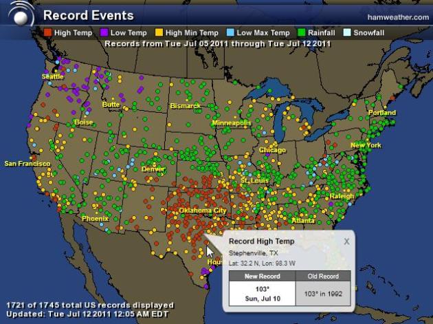
America The Beautiful. Ham Weather has an amazing map that shows (crazy) extremes across the USA in just the last week. 1,745 records, to be exact. Record chill in the Pacific Northwest, record heat over the central and southern Plains states, hundreds of 24 hour rainfall records.

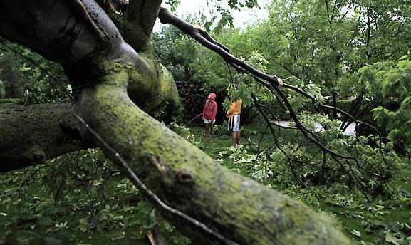
Straight-Line Wind Damage In Sauk Centre Sunday Evening. Here's the latest from the local NWS office:
...PRELIMINARY STORM DAMAGE SURVEY RESULTS FROM THE SAUK CENTRE
AREA IN NORTHWEST STEARNS COUNTY...

A NATIONAL WEATHER SERVICE STORM DAMAGE ASSESSMENT TEAM CONDUCTED A
SURVEY OF THE DAMAGE CAUSED BY THE EVENING STORMS ON JULY 10TH
THAT CAUSED SIGNIFICANT DAMAGE IN THE SAUK CENTRE AREA IN CENTRAL
MINNESOTA. THE FOLLOWING IS A SUMMARY OF THE DAMAGE IN SAUK CENTRE.

EVENT...DAMAGING STRAIGHT LINE WINDS CAUSED BY A SEVERE DOWNBURST.

WIND SPEEDS...75 TO 90 MPH

TIME...RADAR ESTIMATED TO BE BETWEEN 808 PM AND 825 PM. STEARNS
COUNTY EMERGENCY MANAGEMENT NOTED THAT POWER WAS LOST IN THE TOWN
AT 810 PM...WHICH IS WHEN EMERGENCY SIRENS LOST POWER.

DAMAGE...HUNDREDS OF TREES IN SAUK CENTRE WERE UPROOTED OR SNAPPED
OFF WITH THIS LINE OF STORMS. THE SURVEY NOTED THAT ALL OF THE
TREES WERE LAYING TOWARD THE EAST...INDICATIVE OF DAMAGE CAUSED BY
STRAIGHT LINE WINDS. DOZENS OF STRUCTURES WERE ALSO DAMAGED IN THE
TOWN...THOUGH ALL OF THE STRUCTURAL DAMAGE WAS CAUSED BY FALLING
TREES. THE DAMAGE IN THE TOWN WAS EXTENSIVE...WITH ALMOST
CONTINUOUS TREE DAMAGE NOTED FROM INTERSTATE 94 IN THE SOUTH TO
THE SAUK CENTRE COUNTRY CLUB IN THE NORTH. DAMAGE SEEN TO
TREES...UTILITY POLES...AND BILLBOARDS WERE CONSISTENT WITH
WHAT WOULD BE EXPECTED FROM WIND SPEEDS UP TO 90 MPH.
UNFORTUNATELY...POWER TO THE AIRPORT SOUTHEAST OF TOWN WAS LOST
BEFORE THE WINDS COULD BE MEASURED. HOWEVER...THE AIRPORT IN
GLENWOOD MEASURED A WIND GUST OF 76 MPH AND A ROAD WEATHER SENSOR
NEAR ALEXANDRIA MEASURED A WIND GUST OF 79 MPH WHEN THIS STORM
PASSED THROUGH THOSE AREAS.

Heat is the number one weather-related killer in the United States.The National Weather Service statistical data shows that heat causes more fatalities per year than floods, lightning, tornadoes and hurricanes combined. Based on the 10-year average from 2000 to 2009, excessive heat claims an average of 162 lives a year. By contrast, hurricanes killed 117; floods 65; tornadoes, 62; and lightning, 48. Source: NOAA.
- Twenty-three states were under heat advisories Monday, according to the National Weather Service.
- A 51-year-old man in Granite City, Illinois, died Sunday due to the excessive heat. Mitsunari Uechi was found unresponsive in his mobile home, where the air conditioning was not working. Uechi had a body temperature of 104 degrees.
Heat Records For Monday:
- Fort Smith, AR: 107 Old record: 105 in 1954
- Tri-cities Airport, TN: 95 (tie) Old record: 95 in 1988
- Watertown, NY: 90 Old record: 87 in 1987

Never Leave A Child In A Vehicle, Even For A Few Seconds. This time of year the temperature inside a car or SUV can top 110-120 F. within 1-3 minutes. Cracking a window won't help. It's estimated that an average of 38 children die needlessly every summer in this manner, one fatality every 10 days. Never (ever) leave a child in a vehicle, or a pet for that matter. A few horrific statistics:
Child vehicular heat stroke deaths for 2011 YTD: 20
Child vehicular heat stroke deaths for 2010 YTD: 49 (highest # of fatalities for a one-year time period)
Child vehicular heat stroke deaths for 2009: 33
Child vehicular heat stroke deaths from 1998-2010, at least: 495
Average number of child vehicular heat stroke deaths per year since 1998: 38 (one every 10 days)

Kids + Cars = Potential Tragedy. ABC News has a timely story about the perils of leaving children in vehicles: "Young children are particularly susceptible to hyperthermia, said Dr. Gary Smith, director of the Center for Injury Research and Policy at Nationwide Children's Hospital in Columbus, Ohio. "The inside of a car on a hot day heats up incredibly high and quickly," he said. "In a short time, temperatures of 120 to 140 degrees can occur." The heat overwhelms a child's ability to regulate his core temperature and the child quickly loses consciousness, Smith said. "When a kid is in a hot car, he is gaining heat very quickly and there is no way to get that heat out of their bodies. The mechanisms for compensating are overwhelmed and their core temperature rises. The child becomes unconscious and brain damage occurs. A kid left even for a half hour can become unconscious and unresponsive," he said. Historically most children, 51 percent, who die in hot cars are accidently left there by a parent, Null said."
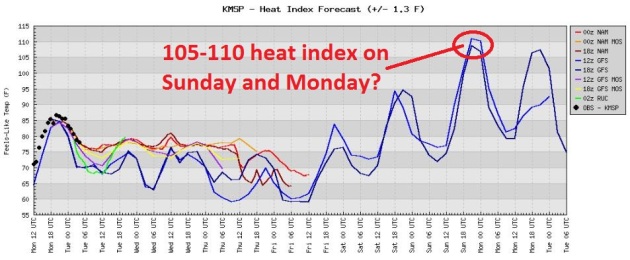
Weekend Outlook: "Beastly Hot". With highs in the mid (to upper) 90s by Sunday and a dew point rising into the mid 70s (again) the projected heat index Sunday afternoon is forecast to range from 105-110 F. That's what it may feel like. I expect the Twin Cities NWS to issue Heat Advisories, possible Excessive Heat Warnings by Sunday afternoon. St. Cloud could easily see a heat index as high as 105 by Sunday afternoon.
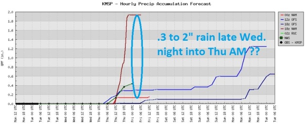
Potential For An MCS Late Wednesday Night - Thursday Morning. The approach of another hot front may set off another spirited round of heavy T-storms Wednesday night into early Thursday, possibly an MCS system, one of those huge, sprawling complexes of strong/severe T-storms, accompanied by torrential rains, frequent lightning and gusty winds. Kind of like a miniature tropical storm pinwheeling across the Upper Midwest. Something to look forward to.
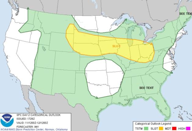
Tuesday Severe Threat. A stationary front separating relatively comfortable air stretching from the Dakotas to the Great Lakes from blast-furnace heat over the central/southern Plains will set off more strong/severe storms later today from Cheyenne and the Black Hills to Des Moines, Madison, Chicago, Indianapolis and Columbus. Stay alert for more watches & warnings.
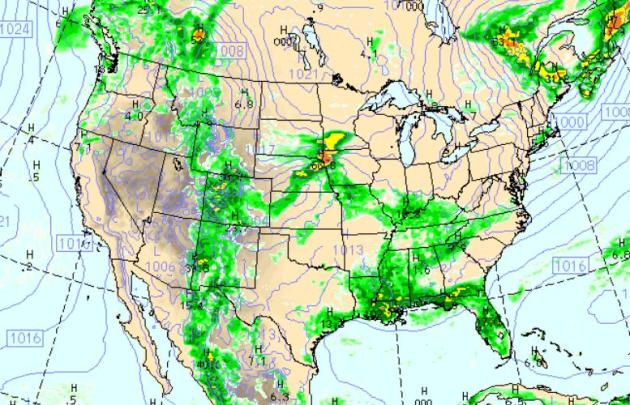
Swarms of Storms. The 4 pm WRF/NAM model prediction shows more strong/severe storm popping over the Rockies, potentially severe storms from southwestern Minnesota and Omaha to Louisville. Texas continues to bake, storms flaring up over the Lower Mississippi Valley and Florida. Light showers spread into the (unseasonably cool) Pacific Northwest, while California and Arizona remain sunny and seasonably warm.
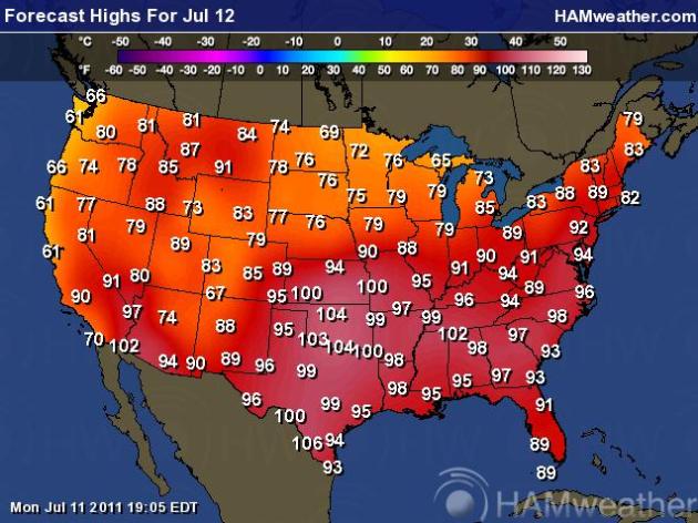
Tuesday Highs. The Great Heatwave of 2011 will continue to burn up the central and southern USA, as many as 8 states from Missouri and Tennessee to Texas and Arizona expecting 100-degree heat. Meanwhile steamy 90s continue over the east coast, while residents of Seattle and Portland reach for sweatshirts, highs in the low to mid 60s.

CAHCG - - gust 76 mph at 9:09 a.m. EDT / 8:09 a.m. CDT - - Chicago Academy in Chicago, IL
KMDW - - gust 75 mph at 9:15 a.m. EDT / 8:15 a.m. CDT - - Midway International Airport in Chicago
CHG08 - - gust 74 mph at 9:15 a.m. EDT / 8:15 a.m. CDT - - Whitney Young HS in Chicago, IL
CHCVS - - gust 71 mph at 9:09 a.m. EDT / 8:09 a.m. CDT - - Von Steuben Metro Science Center in Chicago, IL
DHCGC - - gust 70 mph at 9:09 a.m. EDT / 8:09 a.m. CDT - - Belding Elementary in Chicago, IL
* Thanks to James Aman from EarthNetworks for passing these reports along.
Chicago Blasted By Violent Line Of Thunderstorms, Known As Derecho. Jason Samenow from the Washington Post's Capital Weather Gang has an excellent explanation of derecho's - what hit Chicago on Monday was no ordinary, garden variety line of T-storms: "A ferocious line of thunderstorms with winds to hurricane strength tore through Chicago this morning, knocking out power to more than 660,000 residents. The Weather Channel reports that power provider Commonwealth Edison is saying this could be one of the top five outages in their system’s history. Widespread reports of wind gusts to 70 to 80 mph were observed as the storms raked the area. Midway airported reported a gust to 75 mph and O’Hare gusted to 63 mph. WeatherBug indicates 17 of its local observing stations registered winds of at least 60 mph. The line of storms contained all of the characteristics of a derecho, defined as a widespread, long-lived windstorm associated with a band of rapidly moving showers and storms. The derecho was energized by very strong high altitude winds of 60-70 mph and abundant low level moisture. Its impacts extended well beyond Chicago. AccuWeather’s Henry Margusity tweeted as of 11 a.m. that the storms have traveled 425 miles, produced almost 200 wind damage reports, and caused more than a million power outages. As of 11:30 a.m., the storms stretched from around Lansing, Michigan to Fort Wayne, Indiana. The storms are likely to affect Detroit, Ann Arbor and Toledo Ohio through early this afternoon with the potential for damaging winds."
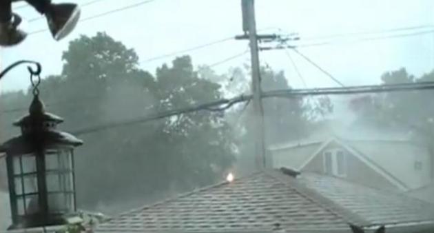
Derecho Video. Check out this YouTube clip of the derecho invading Chicago Monday morning, straight-line winds over 80 mph - the closest thing to a hurricane residents of the Windy City will ever experience. More damage reports:
- Severe thunderstorms swept through the Chicago area Monday morning, pelting commuters and leaving more than 817,000 Commonwealth Edison customers without power at the storm’s peak.
- It was the largest storm ComEd has ever experienced in terms of the number of customers affected.
- 38-year old Joseph Spegel, a father of six was killed just before noon Monday, in Cutlerville, MI when a tree fell on the man's garage. Spegel's wife was also knocked down, but did not require treatment. None of the children were injured.
- One Chicago Streets and Sanitation department worker was injured. The worker was on the phone inside the city offices when a post holding a power line outside was damaged, giving her a bad electric shock. She was taken to the hospital in serious to critical condition, but was doing OK later Monday.
- A Cook County sheriff’s deputy and two convicts the deputy was supervising in south suburban Palos Hills were also treated for injuries Monday afternoon after a tent collapsed during the storm.
- A preliminary storm survey shows that Garrison, Iowa experienced straight line winds of up to 130 mph at around 4:30 a.m. Monday. There was widespread damage to structures, including many roofs were partially or fully removed. Some buildings had collapsed walls. Nearly every tree in town was significantly damaged or snapped off.
- Semi truck overturned in Loves Park, IL
- Semi trailer tipped over near Duncan Mills, IL
- Semi truck blown over in Green Oaks, IL
- Semi overturned at Chicago Midway Airport, IL. Sheet metal torn off roofs.
- Roof blown off house in Poplar Grove, IL. Garage also destroyed.
- Window blown out of a house in Arlington Heights, IL.
- Shed walls blown in in Crest Hill, IL
- Traffic light down in Naperville, IL
- Roof blown off near Libertyville, IL
- Roof taken off ballfield dugout in Lawton, MI.
- Part of a commercial building roof blown off in Benton Harbor, MI.
- Barn damaged and billboard blown over near Union City, MI.
- Semi trailer blown over in Ashley, IN
- Semi trailer blown over near Auburn, IN
- Roof taken off house in St. Marys, WV.
- Siding blown off house in Middlebourne, WV.
- 1.75” (golf ball) hail in Springfield, OH
- 1.75” (golf ball) hail in South Solon, OH
- 1.75” (golf ball) hail in Covington, OH
- 85 mph wind gust near Michigan City, IN
- 81 mph wind gust near Mishawaka, IN
- 80 mph wind gust in Rockford, IL
- 80 mph wind gust near Holland, MI
- 77 mph wind gust in Xenia, OH
- 75 mph wind gust in Crystal Lake, IL
- 75 mph wind gust at Chicago Midway Airport, IL
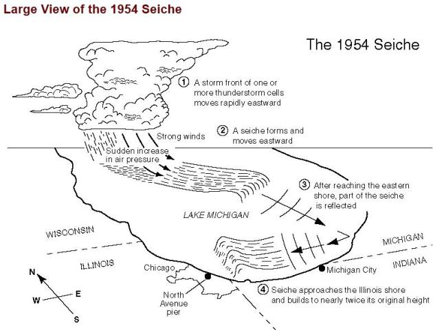
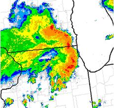
"Seiche Warning". WxBrad has a terrific explanation of what a seiche is - and why residents from Chicago to Cleveland to Buffalo have to keep an eye out for these fickle oscillations in lake-water levels. Here is the Seiche Warning that was issued for Lake Michigan Monday morning:
LAKESHORE HAZARD MESSAGE
NATIONAL WEATHER SERVICE CHICAGO IL
931 AM CDT MON JUL 11 2011

...SEICHE WARNING FOR THE ILLINOIS SHORE OF LAKE MICHIGAN UNTIL
100 PM CDT...

.A STRONG LINE OF STORMS MOVING ACROSS THE LAKE THIS MORNING
LIKELY WILL CAUSE WATER TO PILE UP ALONG THE MICHIGAN AND INDIANA
SHORES AND BE REFLECTED BACK TOWARD THE ILLINOIS SHORELINE. THIS
PHENOMENA IS KNOWN AS A SEICHE.


931 AM CDT MON JUL 11 2011

...LAKESHORE FLOOD WARNING IN EFFECT UNTIL 1 PM CDT THIS
AFTERNOON...

THE NATIONAL WEATHER SERVICE IN CHICAGO HAS ISSUED A LAKESHORE
FLOOD WARNING...WHICH IS IN EFFECT UNTIL 1 PM CDT THIS
AFTERNOON...IN ANTICIPATION OF A POSSIBLE SEICHE.

* LAKE SHORE FLOODING...ALONG THE ILLINOIS SHORELINE OF LAKE MICHIGAN.

* TIMING...THROUGH THE MORNING INTO THE EARLY AFTERNOON.

* IMPACTS...WATER LEVELS ARE EXPECTED TO RISE AND FALL...PERHAPS
  BY 2 OR MORE FEET...DURING THE PERIOD OF THE WARNING.
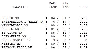
Good-Looking Monday. Subjective? Yes. I don't mind the heat, but the humidity can just zap the strength and energy out of you this time of year. Dew points dropped into the upper 50s on northwest winds Monday, highs ranging from 76 at International Falls to 85 at St. Cloud, 88 in the Twin Cities.

Paul's SC Times Outlook for St. Cloud and all of central Minnesota:
TODAY: Partly sunny, low humidity, still relatively comfortable. A few showers/T-showers may brush far southern Minnesota - should stay south of St. Cloud Winds: NE 7-12. High: 78
TUESDAY NIGHT: Mostly clear and comfortable. Low: 59
WEDNESDAY: Partly sunny, storms far southwestern MN, near the Iowa border? High: 78
WEDNESDAY NIGHT: T-storms, some heavy. Potential for heavy rainfall and frequent lightning. Low: 62
THURSDAY: Morning T-storms. Less sun, more humidity. High: near 80
FRIDAY: Sunny and hot again, stray T-storm possible. Low: 72. High: near 90
SATURDAY: Stinking hot, isolated T-storm, tropical humidity levels (dew points in the mid 70s). Low: 74. High: 93
SUNDAY: Storms early, then hot sun, very humid with an afternoon heat index: 105 to 110. Low: 76. High: 95
MONDAY: Still steamy, more numerous storms. Low: 73. High: 91
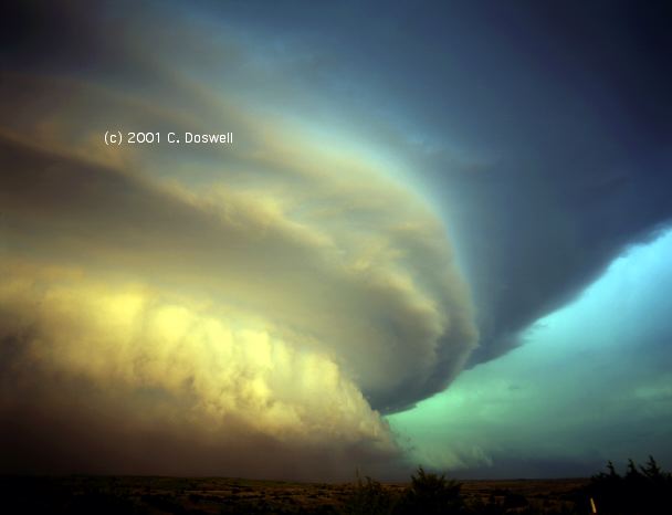
File photo of a derecho courtesy of Chuck Doswell.
Derechos & Gustnadoes
The atmosphere is warming. So what? Come to think of it, I live in Minnesota, and a warming trend sounds like a good idea. There will be benefits: a longer growing season, fewer subzero nights, new plants & birds in your yard. But a warmer atmosphere holds more water vapor, more fuel for severe storms & floods. SPC reports 21,854 severe storm reports so far in 2011. That's more than we saw all last year (21,543). We see a distinct trend - amidst the day-to-day noise of typical weather extremes - to more intense rainfall & more frequent severe local storms.
335 severe reports so far in 2011 in Minnesota. Sunday night's small tornado in Grove City may have been a "gustnado", 80 mph+ straight-line winds spinning up small, brief tornadoes. Sauk Centre was hit by straight-line winds as high as 90 mph Sunday evening. Chicago was also broadsided by a massive "derecho" Monday AM, T-storms with violent straight line winds capable of traveling 500-1,000 miles in a single day.
Fresh Canadian air drops dew points into the 50s today, fine summer weather lingering into Wednesday. T-storms Thursday mark the leading edge of the next hot front; by Sunday the Heat Index may be in the 100-105 range. Low/mid 90s are likely from Friday thru early next week. Get ready for some serious Dog Days by the weekend!

Texas Is Vulnerable To Warming Climate. Here's a recent Op-Ed in the Houston Chronicle: "As you sit by the pool and sweat this summer, one book you should be reading is The Impact of Global Warming on Texas (University of Texas Press, June 2011, second edition). This book, written by a group of Texas academics, is a sober analysis of our state's vulnerability to climate change — and the things we can do about it. It is a particularly appropriate read as we suffer through the hellish summer of 2011. While it is unknown exactly how much human activities are contributing to this summer's unpleasant weather, one lesson from the book is clear: Get used to it. The weather of the 21st century will be very much like the hot and dry weather of 2011. Giving extra credibility to this forecast is the fact that the weather extremes that we are presently experiencing were predicted in the first edition in 1995. The changes in temperature and precipitation, along with rising sea levels, will leave no part of Texas unchanged. This includes both the natural landscape and the cities, the wildlife and important economic sectors, like agriculture. While climate change may be good for some parts of the globe (e.g., Siberia, northern Canada), Texas is most definitely not one of them. Rather, the vulnerability of Texas is more akin to that of the low-lying island states of the Pacific that are going to be inundated by sea-level rise over the coming century. This makes the refusal of our leaders in Austin to take action on climate change that much more unfortunate. There are few qualified atmospheric scientists who would argue with the assessment in the book. And there are none in Texas. Attempts over the last few years to stage a debate in Texas about the science of climate change have required flying a skeptic in from out of state. In one case, they had to import one from Canada. Yet despite the overwhelming agreement by scientific experts on these points, rancorous debate over policy remains. People are worried that policies to address climate change will hurt their standards of living. But unchecked climate change will also cost them money. This summer, for example, Texans with air conditioning are paying quite a bit more for electricity to cool their houses than they have in the past. And while it has not hit yet, the impact of the summer weather will eventually lead to higher agricultural commodity prices.
Thus, there is no free lunch: Either we pay to reduce emissions of greenhouse gases or we pay for the impacts of a changing climate."

Rise Of The Science Radicals. Climate scientists are mad as hell and (apparently) - they're not going to take it any more, as reported by the Canberra Times: "A small band of climate scientists are getting angry as they tackle the indifference to global warming. James Hansen never expected to become a radical activist at the age of 65. He is a grandfather who loves nothing more than exploring nature with his grandchildren. He holds down a respectable job as the director of NASA's Goddard Institute for Space Studies. But he is 70 now, and he has a police record. Hansen gets himself arrested, testifies in court on behalf of others who have broken the law and issues public pronouncements that have made NASA try to gag him all because he can't bear the thought that his grandchildren might hold him responsible for a burned-out planet. Hansen is the climate scientist's climate scientist. He has testified about the issue in front of Congress, but has had enough of the standard government response ''greenwash'', he calls it. Last month, Hansen issued an uncompromising plea for Americans to involve themselves with civil unrest over climate change. ''We want you to consider doing something hard coming to Washington in the hottest and stickiest weeks of the summer and engaging in civil disobedience that will likely get you arrested,'' he says in a letter on grist.org. However many Americans turn up to get arrested in Washington, it's unlikely that Hansen will end up sharing a cell with other scientists. He cuts a lone figure on the barricades; almost all scientists run shy of such public misbehaviour.In private, science has always been a brutal, gladiatorial arena. To be successful you have to challenge established thinking, force out the old guard and prove beyond question that you are right. That takes extraordinary tenacity, resourcefulness and courage."

Extreme Weather Points To Man-Caused Global Warming. Here's a timely Op-Ed from an atmospheric scientist at dailyinterlake.com: "There still seems to be considerable confusion and misunderstanding today concerning whether or not the extreme weather events being experienced around the world and throughout Montana provide evidence of man-caused global warming. While no individual weather events can be ascribed to global warming, increases in the frequency and intensity of these definitely can be. This is because weather is driven primarily by two factors. One is the energy of the sun and the other is water. Water vapor is the only major component of our atmosphere that is condensable under the conditions of our planet. When water vapor condenses to either droplets in clouds, rain, or snow, huge amounts of energy can be released into the atmosphere. Thus, water vapor provides a means of transferring the energy of the sun throughout the Earth via its atmosphere. This is related to global warming because a warmer atmosphere will hold more water and will increase the rate of evaporation. This, in turn, will increase the amount of energy available for release wherever precipitation does occur. Thus, as the Earth continues to get warmer, we can expect the intensity and frequency of extreme weather events to increase on a decadal, if not annual basis. In general, we can also expect dry places to get drier and wet places to get wetter. In addition, water is also the most powerful greenhouse gas. Therefore, we can expect this additional water vapor to further increase the average temperature of the Earth. I regularly ponder the question of what future outcomes of man-caused global warming will be severe enough and obvious enough for essentially all human beings to clearly see what is happening to our planet. Apparently the loss of our glaciers in our own back yard here in Northwest Montana has not been enough to do that. Perhaps this level of recognition will require large rises in sea levels to the point where our major coastal regions and cities are clearly threatened (as New Orleans already is). Because the oceans are so large, however, sea levels are not expected to exceed a foot in the next decade. Therefore that alarm will be going off too slowly to cause immediate and forceful action. I do hope, however, that our rapidly changing weather patterns will “do the job” in a more timely manner."

No comments:
Post a Comment