74 F. dew point reported in St. Cloud Sunday around noon. Dew points drop into the 50s by Tuesday, nearly half as much water in the air than yesterday.

111 F. in Wichita, Kansas on Sunday. Not only was it a record for July 10, it was the hottest day in Wichita since 1980.
106 F. at Joplin, Missouri Sunday, warmest temperature in 25 years.
105 F. high at Oklahoma City yesterday, the 12th day of 100+ heat in a row (21 days above 100 so far this year).
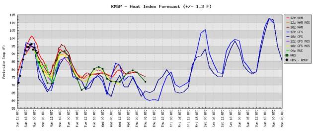
The "Main Event"? All the models bring 90-degree heat back into Minnesota later this week as a massive ridge of high pressure pushes northward across the Plains into the Upper Midwest, Ohio Valley and Great Lakes. Long-range models suggest that the combination of 90-degree heat and dew points rising well into the 70s will make it feel like 105 as early as Friday, possibly 110-115 by Sunday in the Twin Cities!
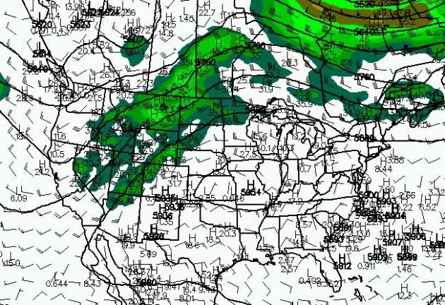
Heat-pump High. 500 mb winds are forecast to (finally) lift well north, allowing a massive ridge of high pressure to stall over Missouri, spreading 90s into the Upper Midwest, 100 degree heat possible as far north as Des Moines and Chicago by the end of the week. The map above is valid Saturday evening at 7 pm.
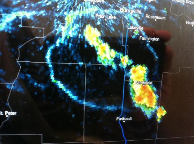
Photo Of The Day: Storm "Ring". I snapped this photo (off my iPad) last Friday when a few isolated T-storms were popping south of the Twin Cities metro. Those circular lines are "outflow boundaries", rain and hail-cooled air reaching the ground and spreading out into miniature cool fronts, moving away from the cluster of storms in ever direction. I thought this was pretty cool. Then again, I am a geek.
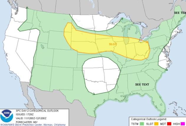
Monday Severe Risk. An eastbound cool front stalls out, running out of "cool push", acting as a meteorological magnet for more strong/severe storms later today from the Black Hills of South Dakota to Des Moines, Chicago and Columbus. Map courtesy of SPC.
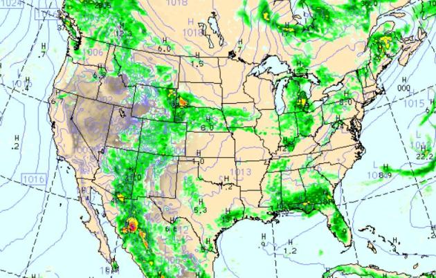
Monday Evening Weather Map. The NAM/WRF model shows the most numerous showers/storms over the Great Lakes and Ohio River Valley, stretching westward to Omaha and Cheyenne, Wyoming. More instability storms sprout along the Gulf coast and central Florida - Texas remains bone-dry.
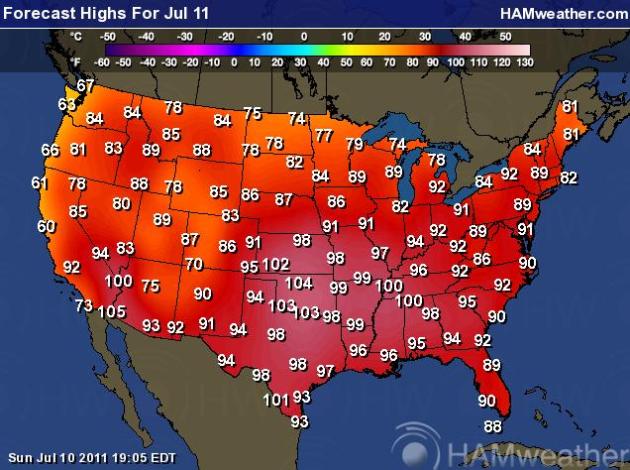
Expanding Heatwave. 100s shift to the north and east, reaching Kansas City, St. Cloud, Memphis and Huntsville, Alabama. Meanwhile a push of cooler, Canadian air drops temperatures into the 70s from the UP of Michigan and northern Minneosta westward to the the Dakotas, unusually cool weather persisting over the Pacific Northwest.

Denver Residents Still Cleaning Up After Flood. Flash flooding last week dumped out 2" of rain in less than an hour or two over the Denver suburbs. The denverchannel.com has more details on the aftermath: "Dealing with floods during severe weather season isn't anything new for the Mayfair neighborhood at East 14th Avenue and Jasmine Street. But what's new this time is the amount of damage the flood left behind."In about an hour we got waist deep water," said Kate McNellis, a Mayfair resident. "It just pours into the crawl space."About 4 feet of water poured into McNellis' crawl space. That was enough to damage her water heater. "I wish I didn't have to pay for it again, but here we are," said McNellis.Just two years ago, McNellis had to replace another water heater because of flood damage. Still, McNellis feels lucky, even after shelling out about $1,500 for her repairs."I just couldn't believe my eyes," said Randy Riggin, a neighbor across the street.The flood waters created a river on the neighborhood street, that flowed right into his backyard and down to his basement."It was like a giant sink drain and everything was pouring down into it," said Riggin.There was so much water that every room his Riggin's 950-square-foot basement had damage."I knew everything was being destroyed in a matter of seconds," said Riggin. "Thirty years of personal items that can't be replaced."

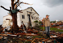
Mental Health Professionals: Emotional Storm Brewing. Many Joplin tornado survivors are experiencing the meteorological equivalent of PTSD, post traumatic stress disorder. The Joplin Globe reports: "JOPLIN, Mo. — When 30 percent of a town is blown away, something is bound to give. Local psychologists say they are seeing increasing numbers of people with agitation, anxiety and depression. Patricia McGregor, a psychologist with Thompson and McGregor, of Joplin, has seen a significant increase in adult clients in the wake of the May 22 tornado. “A lot of these people are direct survivors who have lost family members to the storm,” she said. “They have lost their homes, lost their vehicles, lost their jobs. And, there are the health care workers who were at one or the other of the hospitals who were not prepared to experience what they went through.” So far, three suicides have been linked to the tornado, according to Ozark Center, the mental health arm of Freeman Health System. In a given year, Joplin has six to 12 suicides, said Rob Chappel, coroner of Jasper County. Calls to the local mental health crisis hot line — 347-7720 — have increased significantly. Between May 22 and July 6, the crisis hot line received 1,752 calls, according to Debbie Fitzgerald, crisis intervention coordinator with Ozark Center. Of those, 40 involved people who were having suicidal thoughts. By comparison, the hot line received 371 calls in the month of April."

1.) Register for special assistance. If you will need to evacuate to a shelter and require special assistance, the city asks that you register in advance by calling 727-551-3822.
2.) Special equipment needs. If you require respirators or other electric dependant medical equipment, you should make prior medical arrangements with your physician. Florida law requires utility companies to offer a priority reconnection service for people with disabilities who use power-dependent equipment such as battery-operated wheelchairs or life-support systems. Call your utility company now, so you can be placed on a priority list.
3.) Educate yourself. The Pinellas County Office of Emergency Services offers a wealth of information for special needs and elderly citizens. If you will need assistance in an evacuation, you will need to fill out a form with the County Emergency Management Agency. Call Pinellas County Emergency Management at 727-464-3800 to receive a form by mail."
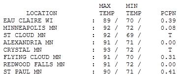
8th Day Above 90 This Year. After a thundery start (flash flood warnings for many southern Twin Cities suburbs early Sunday morning) the sun came out and it got HOT. Highs ranged from 89 at Eau Claire to 92 at St. Cloud and the Twin Cities, 93 at Crystal. Morning storms were fickle: only .08" rain fell at MSP International Airport, while downtown St. Paul picked up .41".
Paul's SC Times Outlook for St. Cloud and all of central Minnesota:
TODAY: Damp start, then sunny, still sticky. Winds: NW 10-15. High: 87
MONDAY NIGHT: Mostly clear, more comfortable. Low: 63
TUESDAY: Partly sunny, less humidity- it will feel MUCH better out there. High: near 80
WEDNESDAY: Sunny start, nighttime storms likely. Low: 60. High: 77
THURSDAY: Scattered T-storms, sticky again. Low: 63. High: 80
FRIDAY: Hot sun, "dog days" return to Minnesota. Low: 70. High: 91
SATURDAY: Hazy sun, muggy. Few T-storms possible. Low: 73. High: 92
SUNDAY: Lake-loitering weather. Few storms flare up. Very hot & humid. Low: 72. High: 93

Why Dew Point?
"Paul, why do you insist on babbling about dew point? Whatever happened to good 'ol relative humidity?" Fair question. Dew point is an ABSOLUTE measure of how much water is in the air - one number that instantly summarizes how it really feels out there. A dew point of 60 is humid, 70 is tropical; we've had 8 hours of 80-degree dew points since 1945. The all-time record is 81 set in July, 1999. A seemingly reasonable relative humidity of 40% (with an air temperature of 95) is oppressive. Dew point is straightforward & simple.
There is a trend toward higher summer dew points, more water vapor the air, more potential fuel for storms (and floods). No, you're not imagining it. Minnesota is becoming more humid over time.
A wind shift to the northwest will begin to drop the drippy dew point later today, but highs flirt with 90 as sun returns statewide. Dew points dip into the 50s tomorrow, a burst of fresh, Canadian air able to shove storms & tropical humidity south & west of town through midweek. Storms return Wednesday night, heralding the arrival of another hot front: low to mid 90s likely Thursday thru the weekend. We'll just get a small taste of the Great Heatwave of 2011.


No comments:
Post a Comment