By Paul Douglas
For half the year we use "Canadian Air" as a pejorative. "How dare they export such cold air south of the border!" Today? "Thank you Manitoba."
We get a welcome 2-3 day break from Hot & Bothered, recovering from the hottest week of 2013, coming 6 weeks later than usual.
According to Dr. Mark Seeley it may have been the hottest State Fair since 1885: 4 days with a heat index above 100F, the latest 80-degree low on record - roughly 100 continuous hours of dangerous heat. School-closing heat. Almost as if Mother Nature looked up at the calendar and decided to make up for lost time.
NOAA reports only 7 Minnesota tornadoes as of Sunday, the fewest since 2007.
No dewpoint-babble today as stiff northwest winds whip up behind last night's thundery cool front. Highs hold in the 70s south, 60s up north with a risk of whitecaps & scattered sweatshirts. Winds ease on Labor Day under a topaz sky, a perfect day to troll the fair or lounge by the lake.
Don't forget sunscreen. The sun is as high in the sky as mid-April, but you can still get fried.
Labor Day marks the traditional end to summer, but don't get all misty-eyed on me yet. Long range models show 90F returning by Friday.
_________________________________________________________
Todd Nelson's SCTimes Outlook for St. Cloud and all of Central Minnesota
SUNDAY: Sunny, windy, cooler. Dew point: 57 Winds: NW 10-20. High: 72
SUNDAY NIGHT: Mostly clear and cooler. Open the window! Low: 47.
LABOR DAY: Best Fair day? Cool, comfortable blue sky. Dew point: 46. Winds: N 5-15. High: 74.
TUESDAY: Cool start. Sunny and warmer. Dew point: 52. Wake-up: 47. High: 81
WEDNESDAY: A few more clouds & warmer. Isolated PM thunder risk? DP: 58. Wake-up: 57. High:80
THURSDAY: Plenty of sun, comfortable. Wake-up: 55. High: 78.
FRIDAY: Sunny, turning warmer again. Wake-up: 57. High: 82.
SATURDAY: More sun and still dry. Lawns and gardens need a drink! Wake-up: 61. High: 85.
________________________________________________________________________________
PM Saturday Severe Recap
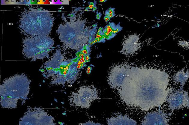
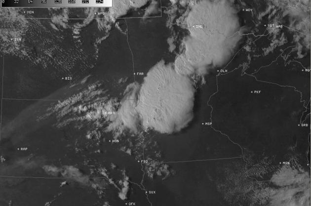
One of my favorite weather products is the visible satellite. If you look at it long enough, you can pick out more and more features. The image below is a picture from nearly 23,000 miles high that shows thunderstorms mushrooming over the Dakotas and northwestern Minnesota from around 4pm Saturday. Those thunderstorms were nearly 10 miles high!
Satellite @ 4pm

Radar @ 4pm
Satellite @ 6pm
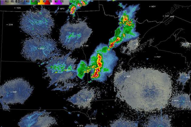
Radar @ 6pm
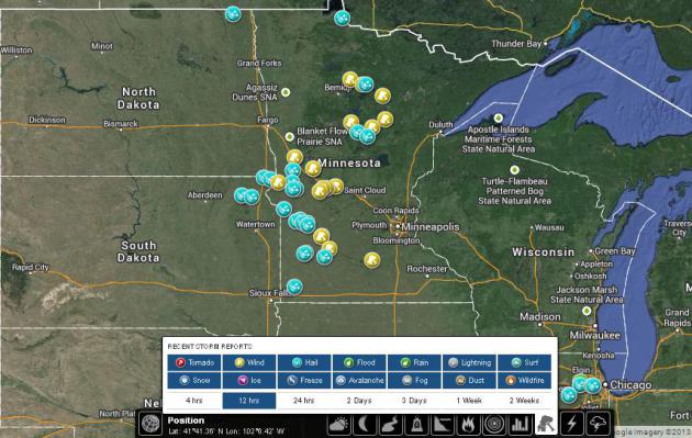
Storm Reports
Here's a look at the storm report map from PM Saturday. Unfortunately for those hoping for a more thundery outcome in the Twin Cities (perhaps for more rain) it dissipated into just some light to moderate showers with a few claps of thunder.
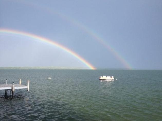
Double Rainbow
This was the view from Leech Lake in Minnesota on Sunday evening as thunderstorms rolled through. It's a double rainbow... it's so intense!!
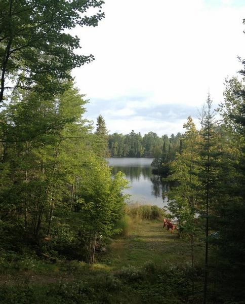
Unofficial End to Summer Weekend
I'm assuming there a lot of folks out there this weekend trying (as best as they can) to soak in this last, unofficial end to summer weekend. Whether it be at the Fair or with family/friend, I hope you're enjoying yourself! Thanks to my good friend Lindsey Elyse Holmes for the picture below, who seems to have the right idea, spending a weekend in Ely, MN. Happy Birthday by the way!
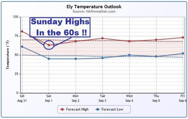
Fall-Like Temps Rest of Weekend
BIG changes are expected post front in parts of the Upper Midwest, especially closer to the international border where temperatures on Sunday are expected to dip into the 60s! In fact, some may not even struggle to get out of the 50s! Here's a look at the temperature trend in Ely, MN.
Happy Meteorological Fall!
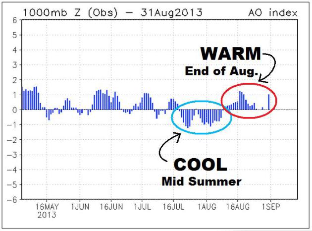
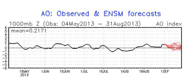
Today marks the date at which the warmests 3 months, on average, are behind us (June, July and August). Interestingly, we went through, what should be, the warmest part of the year and there was a certain fall-like chill in the air. Then we hit mid to late August and summer came roaring back. Take a look at the observed Arctic Oscillation below. Note how the Arctic Oscillation goes negative around mid summer, also coinciding with the cooler than average temperatures for much of the eastern half of the country then. Also note how at the the end of August, the Arctic Oscillation goes negative. This follows the popular belief that when the AO is negative, we're cooler and when the AO is positive, we're generally warmer.
What's Ahead For September?
According to NOAA's CPC, the AO (Arctic Oscillation) forecast suggests that after a few days of cooler weather surrounding Labor Day, we may see temperatures trend a little more toward average for the eastern part of the country.
What Do We Look For?
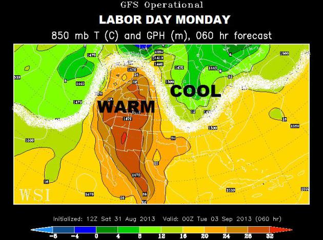
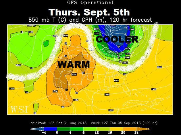
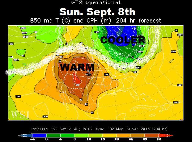
Forecasting weather more than a few days out can be a bit tricky, but it can be easier to follow weather model trends. For example, watching where large ridges and troughs set up can make extended forecasting a little easier. What I'm notcing in the extended weather models are troughs of low pressure trying to make frequent visits to the northeastern quadrant of the nation through the middle of September. See the images below.
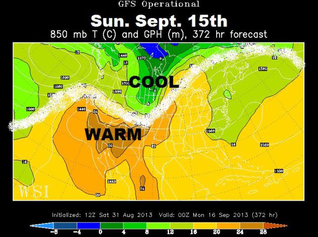
Labor Day Monday
Take a look at the small trough or buckle in the jet stream over the Great Lakes region, that's our current blob of cooler air making its way through the northeastern quadrant of the nation now and what seems to be the start of a little more active/cooler pattern for folks in that part of the country.
Thursday, September 5th
By the middle and end of next week, there appears to be another (perhaps even colder) surge of Canadian air that will just clip the international border around the Great Lakes and Northeast. Additional showers and storms may be possible as it sags southeast.
Sunday, September 8th
By next weekend, another surge of cooler air will clip the northeastern quadrant of the nation, keeping that area in the line of fire. Frequent fronts through early September will keep thing interesting there, but notice how the western part of the country stays relatively warm and dry under a nearly stationary ridge of high pressure.
Mid September Temps
There doesn't seem to be any change in the western part of the country until possibly the middle part of the month when a possible cool front blows through portions of the Northern Rockies/High Plains. Again, it is important to keep in mind that anything past a few days tends to get a little tricky, but the trend shows a more active first half of September (for some) than what we ended the month of August with.
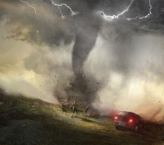
The Legendary Tornado Chaser Tim Samaras' Last Ride
Some of you may remember that earlier this year, the meteorological community lost some very important people in earlier this year in the El Reno, OK tornado. This is an interesting read by Brantley Hargrove:
"The curtain overtook him again and the rain came faster, with a sound against his windshield like stones against glass. His Toyota lurched to the side in 100-mph gusts and began fishtailing in the gravel, causing the car's traction control to cut power to the wheels. He backed off on the accelerator to override it. He did this again and again, never maintaining a speed faster than 42 mph. "The car won't go!" he said.
He punched through swirling eddies of rain. His windshield
wipers couldn't clear the water from his windshield. He drove on,
blind."
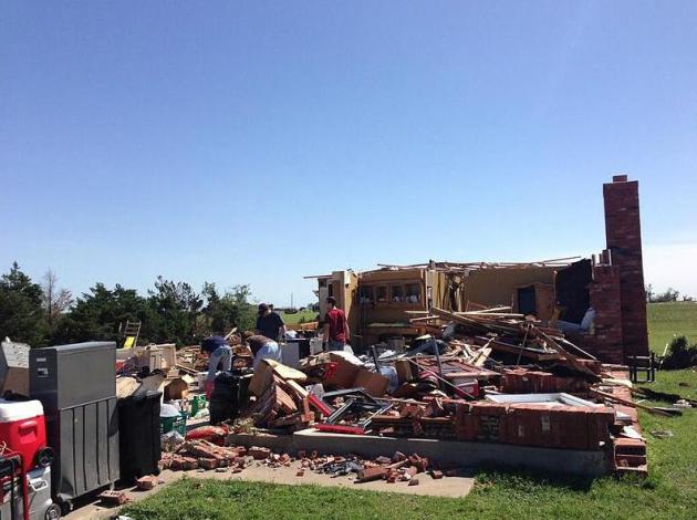
New Information on El Reno, OK Tornado
I thought this was interesting about the El Reno tornado that was originally rated an EF5, but recently changed it's rating to and EF3.
"Most of us will never forget the tornado outbreak in May. On May 31, a large tornado moved through El Reno and was originally rated an EF-5 by the National Weather Service in Norman."
Read more from KOCO.com out of Oklahoma City, OK HERE:
Thanks for checking in, have a great rest of your long holiday weekend!
Don't forget to follow me on Twitter @TNelsonWNTV

No comments:
Post a Comment