Labor Day Flashback
Labor Day 2013, a chance to look back and
remember the odd jobs I've had over the years.
Delivering newspapers -
on a minibike, making subs & pizzas, washing dishes at a Sheraton
(worst job ever?), being told by McDonalds that I wasn't "management
material". That hurt. Asking a kid in high school study hall if the AM
radio station he worked at had their own on-air weatherman. Updating 11
FM stations from a payphone in my (noisy) college dorm. Standing
outside, like a wayward postal carrier, pointing to a green screen,
trying to make sense of the weather for a string of TV stations.
Launching my own TV weather studios in 2008, only to participate in a
new national weather channel two years ago. Didn't see that coming. In
fact my meteorological career has been tougher to predict than the
weather, taking some odd twists and turns, more pleasant surprises than
unpleasant setbacks.
It's been a strange and wonderful ride with great friends along the way. No regrets.
Today will be a meteorological breath of fresh
air: blue sky, dew points in the 40s - a preview of coming attractions.
Enjoy what may be the best day at the fair, because summer isn't nearly
done with us yet. Highs may reach or top 90F from Thursday into
Saturday. That's on top of the 16 days of 90-plus highs since May.
Average is 13. Last summer: 31 days at/above 90F.
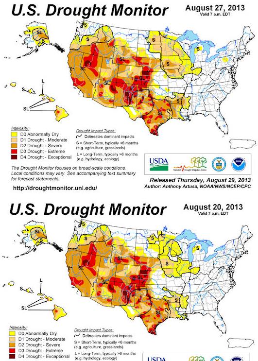
More than half the state is in a moderate
drought again; I don't see any rain until Sunday & Monday of next
week.
In fact I'm seeing a warm, dry bias into much of
September. Long range guidance shows 80s looking out 2-3 weeks.
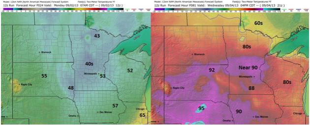
Big Extremes. After waking up to 40s across much of
central and northern Minnesota this morning, temperatures will be 40
degrees warmer by Wednesday afternoon as surface winds turn to the
southwest. Maps above: Ham Weather.
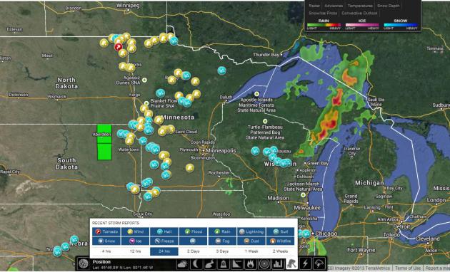
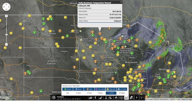
Saturday Damage Reports. Winds gusted as high as
60-70 mph. over northern and western Minnesota, before the squall line
weakened as it pushed into the Twin Cities after the dinner hour. Hail
up to 2" in diameter was reported at Montevideo, at least one funnel
cloud spotted northwest of Grand Forks. Interactive map above: Ham
Weather.
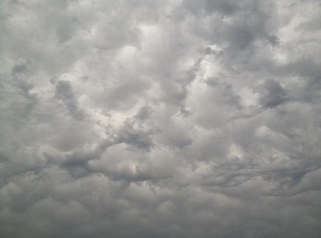
A Chaotic Sky. WeatherNation TV meteorologist Bryan
Karrick snapped this photo of undulatus asperatus near Cologne late
Saturday as a weakening squall line was approaching the Twin Cities
metro area.
Flash Drought: New Term Coined To Describe Summer's Strange Weather. I thought this article from
LaCrosseTribune.com
captured the moisture (and temperature) whiplash we've experienced this
summer: too much moisture early in the planting season, far too little
by August, with huge swings in temperature accompanying these
meteorological flip-flops. Here's an excerpt: "
The region’s mood
swing from cool, soggy spring to parched yet sweltering late summer has
coined a new weather term: flash drought. The label reflects how
quickly conditions have deteriorated in the region under the withering
combination of weeks without rain coupled with extreme heat at a
crucial time for maturing crops, said Todd Shea, a meteorologist with
the National Weather Service in La Crosse....This quick-onset drought
also comes in a year in which crops that otherwise might have endured
the dry spell already were delayed by, ironically, too much rain that
pushed planting in some fields until mid- to late June. “It’s been a
year that’s not been like any in recent memory,” Steve Huntzicker, in
his eighth year as La Crosse County UW-Extension agricultural agent,
said of the conditions...."
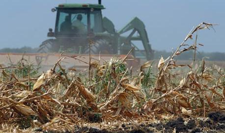
Photo credit: Chris Hardie. "
A cornfield near Ettrick show signs of stress from the recent drought."
Midwest DrynessIntensifies; Plains Drought Sustained.
Farm Futures has more on the sudden onset of moderate drought across much of the state: "
Higher
than normal temperatures coupled with minimal rainfall has kept the
Midwest in a "flash drought" late in the summer season, the latest U.S. Drought Monitor
reports, while rain the Plains continues to be minimal. Rapid onset of
heat and diminishing soil moisture is taking a toll on Midwestern
crops, however, regional waterways are not yet showing much impact.
According to the USGS, approximately three-quarters of Midwestern
stream flows are close to normal for this time of year, with most of
the remainder registering as below-normal, the Drought Monitor reports.
The dryness is in stark contrast to the wet spring many areas of the
Midwest experienced; for example, Burlington, Iowa, this year had its
wettest spring on record since 1898, with 19.23 inches of precipitation.
Burlington is now on track to experience its driest summer on record
since 1898, with only 3.86 inches of precipitation so far..."
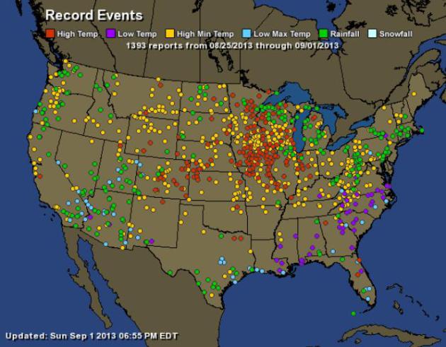
A Week's Worth Of Records.
Ham Weather interactive graphics
show dozens of record afternoon highs and (warm) nighttime low
temperature records in the last 7 days, even a few 24-hour rainfall
records over northern Minnesota and Wisconsin.
Big Extremes For Late August. NOAA data shows the
focus on record heat last week over the Midwest, with (fewer) record
lows over the southern USA. Green dots are 24 hour rainfall records over
the last 7 days. More details from
Ham Weather:
| Total Records: |
1393 |
| Rainfall: |
245 |
| High Temp: |
244 |
| Low Temp: |
63 |
| Low Max Temp: |
84 |
| High Min Temp: |
757 |
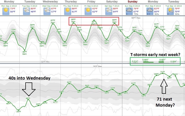
Autumn or Summer? ECMWF guidance (above, courtesy of
Weatherspark) shows some big swings over the next week; 40-degree dew
points keeping us comfortable into Wednesday as temperatures slowly
warm. I don't see a significant chance of rain until early next week,
when dew points may clip 70F, meaning more than twice as much water in
the air. Don't write summer (weather) off just yet.
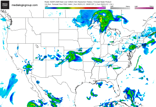
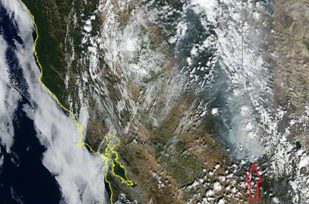
60-Hour NAM. Here's the 4 km solution from the 12z
Sunday run, showing heavy showers and T-storms spreading from the Ohio
Valley into the Northeast and New England, a potential for showers near
Yosemite (hopefully giving 5,000+ firefighters at the Rim Fire the upper
hand in the coming days). Still quiet in the tropics, for now.
Animation: Ham Weather.
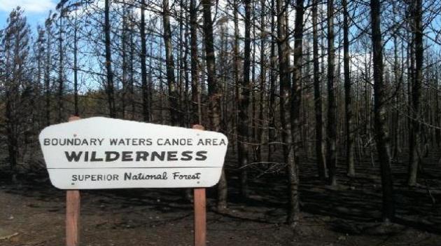
BWCA Fire Declared 100% Contained. Here's a clip from a story at AP and
KARE-11: "
U.S.
forestry officials say the last remaining wildfire in the Boundary
Waters Canoe Area Wilderness has been declared 100 percent contained. A
Duluth News Tribune report says the 188-acre Knife Lake fire will be
declared officially controlled once additional clean-up work is
finished. Two firefighters remained on the scene Saturday for patrol
work and clean-up. The fire was located near the South Arm of Knife
Lake, northeast of Ely near the U.S.-Canadian border. The largest fire
burned at least 15 to 20 acres. A Superior National Forest
spokeswoman says heavy rains last week helped aid the containment
efforts..."
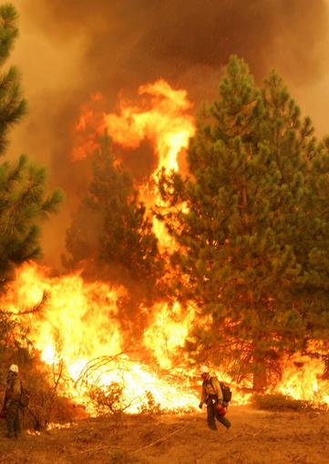
Sierra Wildfire Now California's Fourth-Largest. Here's an update from
UTSanDiego.com: "
The
wildfire burning in and around Yosemite National Park has become the
fourth-largest conflagration in modern California history, fire
officials said Sunday as clouds and higher humidity helped crews further
contain the biggest blaze in the United States this year. The
2-week-old Rim Fire moved up a spot on the state's list of large
wildfires dating back to 1932 when it grew to 348 square miles - an area
larger than the cities of San Francisco, Oakland and San Jose combined
- on Saturday, California Department of Forestry and Fire Protection
spokesman Daniel Berlant said. Although the fire still is growing, it
was 40 percent contained as of Sunday, up from 35 percent a day earlier..."
Photo credit above: "
In this Friday, Aug. 30, 2013 photo
provided by the U.S. Forest Service, a member of the Bureau of Land
Management Silver State Hotshot crew from Elko, Nevada, stands by a
burn operation on the southern flank of the Rim Fire near Yosemite
National Park in California. The wildfire burning in and around Yosemite
National Park has become the fourth-largest conflagration in California
history." (AP Photo/U.S. Forest Service, Mike McMillan)
Possible Marijuana Link To Massive California Wildfire. Here's a new potential angle on how the fire got started that I hadn't seen before, an excerpt of a story at
theSundaily.com: "
Investigators
probing the massive wildfire in Yosemite National Park are looking
into whether an illegal marijuana farm may have triggered the blaze, US
media reports said Saturday. As the vast wildfire continued to rage in
the iconic Californian tourist destination, several reports quoted a
local fire chief who suggested marijuana growers may be to blame. Todd
McNeal, a fire chief in Twain Harte, one of the towns affected by the
219,000-acre (88,630 hectare) inferno, said investigators had not
pinpointed the cause of the blaze. "We don't know the exact cause,"
McNeal was quoted as telling a community meeting. However, he added it
was "highly suspect that there might have been some sort of illicit
grove, a marijuana-grow-type thing." "We know it's human caused. There
was no lightning in the area," he said..."
No Atlantic Hurricane By August In First Time In 11 Years.
The probability of an average or above-average hurricane season in the
Atlantic is dwindling with each passing day. Details from
bloomberg.com: "
August
is about to end without an Atlantic hurricane for the first time since
2002, calling into question predictions of a more active storm season
than normal. Six tropical systems have formed in the Atlantic since the
season began June 1 and none of them has grown to hurricane strength
with winds of at least 74 miles (120 kilometers) per hour. Accumulated
cyclone energy in the Atlantic, a measure of tropical power, is about 30
percent of where it normally would be, said Phil Klotzbach, lead author of Colorado State University’s seasonal hurricane forecasts. “At this point, I doubt that a super-active hurricane season will happen,” Klotzbach said in an e-mail yesterday..."
Four Reasons You Shouldn't Exist. Yes, science is an
important tool, but it only goes so far. For example, it has no answers
for why (ultimately) we're here, reading articles questioning why we're
here. Here's an excerpt of a head-scratching article from
Slate: "
You’re
almost unfathomably lucky to exist, in almost every conceivable
way. Don’t take it the wrong way. You, me, and even the most calming
manatee are nothing but impurities in an otherwise beautifully simple
universe. We're lucky life began on Earth at all, of course, and that
something as complex as humans evolved. It was improbable that your
parents met each other and conceived you at just the right instant, and
their parents and their parents and so on back to time immemorial.
This is science’s way of reminding you to be grateful for what you
have. But even so, I have news for you: It's worse than you think. Much
worse..."
Graphic credit above: "
Amid perfect cosmic symmetry, there's us." Illustration by Alex Eben Meyer.
"Walking" Shark Discovered In Indonesia. Chalk
Indonesia off the bucket list. Suddenly the "Land Shark" skits from
SNL don't seem quite so funny - good grief. Here's a clip from
Yahoo News: "
A
new species of shark that "walks" along the seabed using its fins as
tiny legs has been discovered in eastern Indonesia, an environmental
group said Friday. The brown and white bamboo shark pushes itself along
the ocean floor as it forages for small fish and crustaceans at night,
said Conservation International, whose scientists were involved in its
discovery. The shark, which grows to a maximum length of just 80
centimetres (30 inches) and is harmless to humans, was discovered off
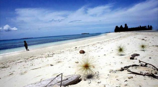
Halmahera, one of the Maluku Islands that lie west of New Guinea...."
Photo credit above: "
A tourist walks along a white sand
beach in Doloda Island, North Maluku, Indonesia, on August 25, 2006. A
new species of shark that "walks" along the seabed using its fins as
tiny legs has been discovered in eastern Indonesia, an environmental
group said Friday." (AFP Photo/Adek Berry).
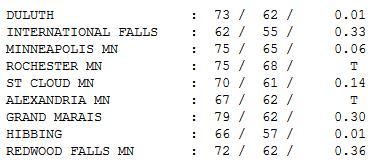
70 F. high in St. Cloud Sunday.
76 F. average high on September 1.
85 F. high on September 1, 2012.
Whispers of Autumn. Yesterday was a crude reality
check, a subtle (yet blunt) reminder that, as far as the atmosphere is
concerned, it's already autumn. Meteorological Autumn, marking the end
of what is historically the 90 warmest days of the year, is September 1.
That wasn't hard to believe Sunday, with highs holding in the 60s from
Alexandria to Brainerd to International Falls (62F). Saturday evening
showers and T-storms dropped up to a third of an inch of rain on parts
of northern Minnesota, with .36" reported at Redwood Falls, only .06" in
the Twin Cities.
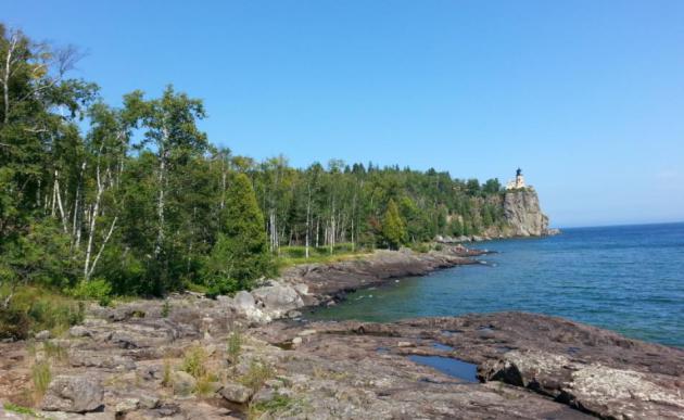
Severe Clear. Thanks to WeatherNation TV meteorologist Mace Michaels, for a photo of
Split Rock Lighthouse on the North Shore.
LABOR DAY: Sunny. less wind. Winds: N 10. Dew point: 48. High: 73
MONDAY NIGHT: Clear and cool. Low: 45
TUESDAY: Sunny and warmer. High: near 80
WEDNESDAY: Plenty of sun, feels like summer again. Wake-up: 56. High: 84
THURSDAY: Blue sky, almost sticky. Dew point: 61. Wake-up: 60. High: 87
FRIDAY: Sunny - a hot afternoon. Wake-up: 61. High: near 90
SATURDAY: Sunnier, drier day of weekend. Nicer day for outdoor plans. Wake-up: 62. High: near 90
SUNDAY: Welcome showers & T-storms. Wake-up: 63. High: 76
Climate Stories...
Climate Change Deniers At War With Military Over Green Energy. Here's an excerpt of a story at
billmoyers.com: "
When Congress returns from vacation in a week and a half, the Senate will take up the National Defense Authorization Act
(NDAA), the bill that sets the Department of Defense (DoD) budget —
and defense-related budgets for other departments — and mandates how
America’s military leaders use that funding. Last year, the fight over
the NDAA got stuck on the Pentagon’s plans to make the military’s
operations greener and more sustainable. Republicans in particular went
after Navy Secretary Ray Mabus’ plan for a “great green fleet”
powered on alternative energy — a play on Theodore Roosevelt’s vision
of a “great white fleet” that would circumnavigate the world and define
the U.S. as a key international player. Mabus’ goal is for his forces
to draw 50 percent of their energy from alternative sources by 2020..."
Photo credit above: "
U.S. Navy officers and sailors stand
at attention as U.S. Navy ship USS Freedom (LCS 1) berths at the Changi
Naval Base on Thursday April 18, 2013 in Singapore." (AP Photo/Wong Maye-E).
Spread Of Global Crop Pests Threatens Global Food Security As World Warms.
EurekAlert has the story - here's an excerpt : "
A
new study has revealed that global warming is resulting in the spread
of crop pests towards the North and South Poles at a rate of nearly 3
km a year. The study, published in the journal Nature Climate Change
and carried out by researchers at the University of Exeter and the
University of Oxford, shows a strong relationship between increased
global temperatures over the past 50 years and expansion in the range of
crop pests. Currently 10-16% of global crop production is lost to
pests. Crop pests include fungi, bacteria, viruses, insects, nematodes,
viroids and oomycetes. The diversity of crop pests continues to expand
and new strains are continually evolving. Losses of major crops to
fungi, and fungi-like microorganisms, amount to enough to feed nearly
nine percent of today's global population. The study suggests that
these figures will increase further if global temperatures continue to
rise as predicted..." (File photo: Star Tribune).
Winding Up The Global Spring Of Planetary Catastrophe.
In a nutshell, we don't know what we don't know. And nature rarely
moves in a perfectly straight line. Tipping points? Unintended
consequences that climate models can't possibly see in advance? We're in
uncharted waters with Earth's climate system, odds are pretty good
things will pop up that we hadn't expected. Here's a clip from
Huffington Post: "
I
was always taught that if you don't know how something works, you
shouldn't mess with it. The Earth's climate represents a wonderfully
complex dynamical system that we do not fully understand. Some
components are in a delicate balance. As we continue to shift that
balance by disrupting our atmosphere's cooling capacity, there is no
telling what will happen...One of the most ominous aspects of global
warming is the apparent "plateau" in global mean surface temperature.
We know from basic physics and from observations that more energy is
entering the earth's atmosphere than is escaping to space. All that
heat is being stored. We don't know exactly where, or what effects it
will have. It's as if we are winding up a giant spring that us pushing
back and giving the appearance of stability that cannot be real.
There is some evidence that the gigantic spring is the Pacific Ocean. Eventually, something is going to give..."


No comments:
Post a Comment