By Todd Nelson
"Yesterday's history, tomorrow's a mystery, today is a gift!"
This Labor Day weekend will be a memorable one for us in the Nelson household as we will be sending our oldest off to kindergarten in a few days. The sign on the school says "Welcome class of 2027" - GULP! I think I remember watching movies back in the day that had us driving flying cars at that point.
It has been a somewhat soggy go of things over the past couple of days. There will be a few lingering puddles on Saturday, but the weather will be fair for the Fair. It'll still be a bit muggy, but lingering clouds with peeks of sun shouldn't have any impact on your food consumption.
We warm up Sunday ahead of a developing storm system that could bring strong to severe storms close to home by late afternoon/evening hours. The Storm Prediction Center has already placed much of Minnesota under an enhanced thunderstorm risk, so stay tuned to weather maps near you.
Summer's last gasp quickly moves out by the start of Meteorological Fall on Monday. Other than having to tiptoe over a few puddles filled with remnant somethings on a stick, you should have no problem looking for some last minute deals -Todd Nelson
=================
FRIDAY NIGHT: Rain/thunder threat continues. Low:59
SATURDAY: Best day? Patchy fog, then intervals of sun. Dew point: 64. High: 77
SATURDAY NIGHT: Partly cloudy, quiet. Low: 59.
SUNDAY: Sticky sun, severe T-storms late? Dew point: 67. High: 84
LABOR DAY: AM puddles. Sunny and less humid. Wake-up: 61. High: 75
TUESDAY: Back to school. Average for early September. Wake-up: 53. High: 76
WEDNESDAY: Few afternoon clouds, still dry. Wake-up: 54. High: 78
THURSDAY: Increasing clouds, growing PM thunder risk. Wake-up: 58. High:79
FRIDAY: Unsettled. Scattered T-Storms. Wake-up: 59. High: 81.
================
This Day in Weather History
August 30th
1977: Flooding on the southwest side of the Twin Cities, with the international airport getting 7.28 inches of rain in 4 1/2 hours.
===============
Average High/Low for MSP
August 30th
Average High: 78F (Record 96F set in 1941)
Average Low: 59F (Record 45 set in 1974)
================
Sunrise/Sunset Times for MSP
August 30th
Sunrise: 6:33am
Sunset: 7:53pm
================
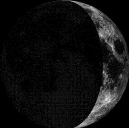
Moon Phase for August 30th at Midnight
2.2 Days Before First Quarter
========================
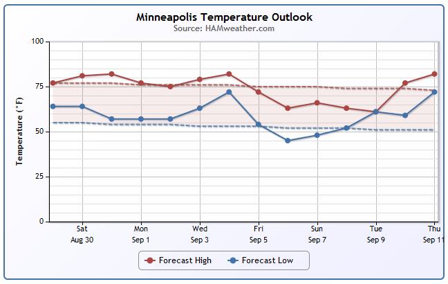
Minneapolis Temperature Trend
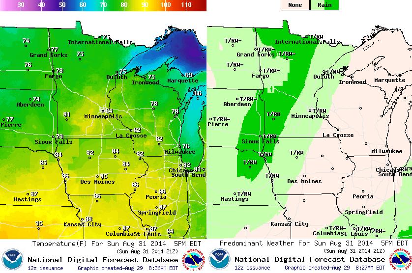
Meteorological Fall starts Monday, September 1st. That means the warmest 3 months (on average) for the northern hemisphere will be behind us. Looking ahead to the early part of September, there could be a bigger cool down headed our way by late next week/first weekend of September. In the meantime, temperatures through the weekend look to stay slightly above average with a bit more humidity.
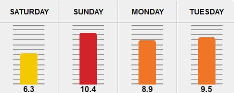
Allergy Alert
According to Pollen.com - this weekend could be a rough one for seasonal allergy sufferers. Sunday, pollen levels look to spike considerably, but it doesn't look much better on Labor Day Monday.
Saturday Weather Outlook
We'll see improving weather conditions on Saturday. There could be a few leftover puddles and lingering showers in the early part of the day, but the sun should break out with highs approaching 80 by the afternoon. In my opinion, Saturday looks like the better Fair day.
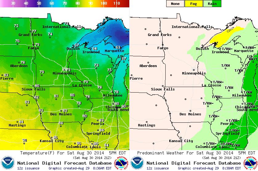
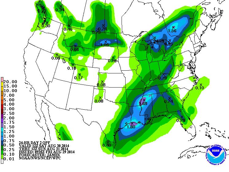
Saturday Rainfall Potential
Here's the national rainfall forecast from AM Saturday through AM Sunday. Note the larger swath of rainfall from the Great Lakes to the Gulf Coast, this is the rainfall threat we endured Friday. Saturday looks to be the drier day of the weekend as Friday's rain moves east, however there is another system moving in for Sunday.
Sunday Weather Outlook
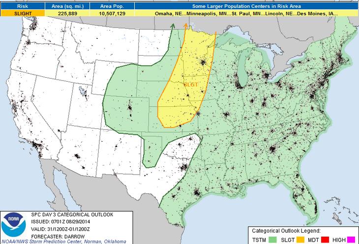
Sunday will start off dry, but it'll quickly get warm and more humid as our next storm system approaches. There is a growing thunderstorm risk by late afternoon/evening across western MN that could wind up rolling into the Twin Cities by the evening/overnight. The Storm Prediction Center has put most of Minnesota under a SLIGHT RISK of severe weather for PM Sunday... Stay tuned!
Sunday Severe Risk
Here's the latest from NOAA's SPC regarding Sunday's severe weather potential:
SIGNIFICANT SHORT-WAVE TROUGH WILL MIGRATE INTO THE HIGH PLAINS SUNDAY AFTERNOON WITH MODEST WSWLY FLOW FORECAST TO OVERSPREAD THE IMMEDIATE FRONTAL ZONE AS FAR SOUTH AS KANSAS...AND ALONG THE DRYLINE ACROSS THE TX PANHANDLE. LARGE SCALE PATTERN IS EXPECTED TO BE SUBSTANTIALLY DIFLUENT ALOFT WHICH SHOULD ENCOURAGE QUITE A FEW STORMS TO EVOLVE ALONG WIND SHIFT BY LATE AFTERNOON AS CINH WEAKENS. THUNDERSTORMS MAY BE ONGOING AT THE START OF THE PERIOD ACROSS PARTS OF ND/NRN MN BUT THIS CONVECTION SHOULD BE ELEVATED AND POSSIBLY POST-FRONTAL BEFORE LIFTING NORTH OF THE INTERNATIONAL BORDER. OF MORE CONCERN WILL BE TSTMS THAT DEVELOP ALONG THE FRONT BY MID-LATE AFTERNOON...INITIALLY ACROSS MN...THEN PROGRESSIVELY SW ALONG THE WIND SHIFT ACROSS NEB INTO KS WHERE TEMPERATURES SHOULD SOAR INTO THE MID 90S. DEEP LAYER SHEAR IS FORECAST TO BE SUPPORTIVE OF AT LEAST ORGANIZED MULTI-CELL CLUSTERS AND A FEW SUPERCELLS MAY ULTIMATELY DEVELOP TOWARD EVENING WHEN SHEAR/LLJ INCREASES...ESPECIALLY ACROSS THE CNTRL PLAINS. LARGE HAIL AND STRONG WINDS ARE THE PRIMARY THREATS WITH NEAR-FRONTAL CONVECTION. SEVERE THREAT COULD LINGER WELL INTO THE EVENING HOURS AS SHORT WAVE EJECTS TOWARD THE MID MO VALLEY.
See more from NOAA's SPC HERE:
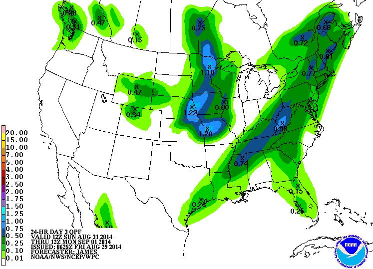
Sunday Rainfall Potential
Sunday's storm chance will not only bring us a strong to severe weather threat, but there will be some hefty rainfall totals possible as well. According to NOAA's HPC, the rainfall potential from AM Sunday to AM Monday could bring 1" of rain or more across parts of the Upper Mississippi Valley.
Weather Outlook
It's pretty easy to see the two different storms systems that we'll be dealing with over the weekend. One moving east of us by Saturday, while the second one will be moving into the Upper Mississippi Valley by Sunday. That second one is the one that could bring strong to severe storms close to home.

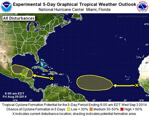
Atlantic Outlook
According to NOAA's NHC, the Atlantic Basin still looks to stay fairly quiet over the next 5 days. There are only 2 weak disturbances that have only a low chance of further development.
Thanks for checking in and have a great weekend ahead! Don't forget to follow me on Twitter @TNelsonWX

No comments:
Post a Comment