20 F. high temperature in St. Cloud Sunday.
22 F. average high on December 27.
27 F. high on December 27, 2014.
December 28, 2000:
Central and southeast Minnesota receive 6 to 10 inches of snow. Some
notable snow amounts include: Chanhassen NWS Forecast Office with 7.8
inches, St Cloud with 7.5 inches, and Hutchinson, Willmar, Albany, Red
Wing, and Long Prairie with 7.0 inches.
December 28, 1979: Balmy weather enables the city park crew in Duluth to rake leaves.
December 28, 1927: A cold snap results in sharp temperature drops across Minnesota. The temperature would fall from 41 to -15 at Farmington.
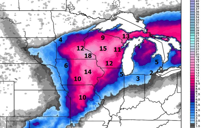
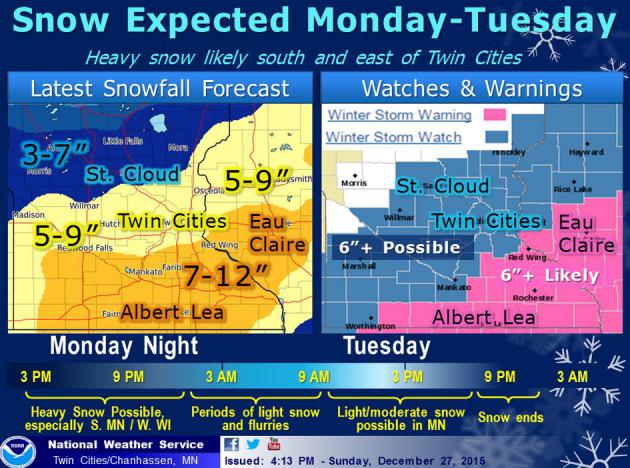
 Growing Threat (Opportunity) for 6-12" Snow Tonight into Tuesday
Even More for Southeastern Minnesota - White Out Conditions Expected Tonight
We
all know the weather in these parts can turn on a dime. Snap your
fingers and there's a brand new sky draped overhead. In the span of 4
days the Twin Cities will make up for a 1 foot snowfall deficit. 2-4
inches fell early
Saturday; another 6-12 inches will fall from late afternoon into
Tuesday.
No mix, no rain - cold enough for all snow this time, and it may come down at the rate of 1-2 inches an hour between
6 PM and 2 AM Tuesday.
Never tell a Minnesotan not to drive, but I'd suggest getting errands done this morning, maybe leave for home by 3 or
4 PM to get out in front of the snow bands. I'll write you a note.
Heavier
snow bands set up south and east of MSP, some 12-18 inch totals
possible from Mankato and Rochester to Northfield and Red Wing with
treacherous travel for much of central and southern Minnesota into
central Wisconsin. I would not want to be on the roads tonight. I don't
care if you have AWD or an F-350. It will still be bad. But the storm is
moving quickly; most of the accumulating snow will be over by
Tuesday afternoon.
A
nippy New Year's Eve is shaping up but I still don't see anything polar
screaming south of the border. Seasonably cold; we've just lost track
of "average".
It was the warmest autumn on record - but winter is about to make up for lost time.
Storm Headlines:
-
Try and get your errands done during the morning and midday. Snow will
arrive by 4 PM and most roads will be snow-covered by 5 or 6 PM. I
wouldn't hesitate leaving work a little early to get out in front of the
snow.
- The heaviest snowfall rates come this evening and
tonight; snow may fall at the rate of 1-2"/hour at times, with as much
as 8-10" on the ground in and around the metro by Tuesday morning's rush
hour. Which will be anything but, looking at the latest guidance.
-
Heaviest snows fall tonight, but periods of light snow may drop another
1-3" Tuesday and Tuesday night, bringing overall totals into the 6-12"
range.
- Expect moderate blowing and drifting tonight as winds
gust to 25 mph. Near white-out conditions are possible at times, and
despite best efforts MnDOT crews won't be able to keep roads clear,
especially outside the metro area. I say this with all respect and
humility: think twice before driving tonight.
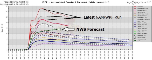
WRF Solution: Close to a Foot?
Sorry this is hard to read (a bad eye test), but 4 KM WRF guidance is
printing out 12 and 13" amounts for the Twin Cities metro by Tuesday
evening (although most of that will come tonight). Before I saw this
solution, and the raw NAM numbers, I was inclined to go 5-8" for the
metro. After seeing this solution (coming more in line with 5 ECMWF runs
in a row) I'm inclined to go higher, possibly as high as 10-12" for
parts of the metro, especially suburbs south and east of St. Paul.
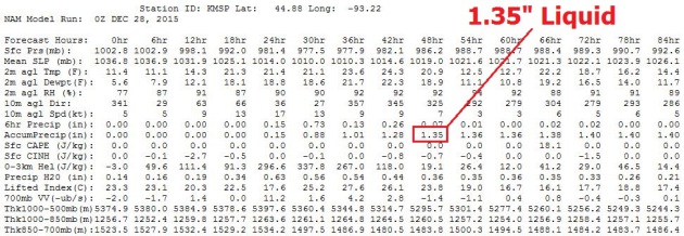
OMG.
Last night's 00z NAM numbers filled me with panic, and a strange sense
of euphoria. "You're telling me we have a chance?" Yep. With
temperatures in the low to mid 20s and the lowest mile of the atmosphere
well below 32F I don't see a changeover to an icy mix. Not this time.
And 1.36" liquid translates into close to 10-12", assuming a snow/rain
ratio of 10/1, which should be close. Translation: we may wind up with
an old fashioned "snow storm". Remember those?
*
Expect moderate drifting tonight
with sustained winds of 15-25 mph and a few gusts as high as 25-30,
especially outside the metro area. I would not recommend travel tonight
(anywhere within 200 miles of MSP). Winds ease up a little on Tuesday,
giving MnDOT road crews a better chance to dig out.
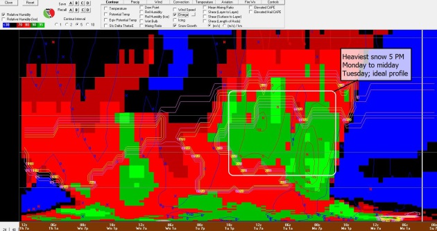
Bufkit Analysis.
Another graphic that may leave you scratching your head. This is a
cross-section of the atmosphere over MSP from Sunday night through
Wednesday, showing an profile ripe for heavy snow. Strong upward motion
(omega) coincides with ripe conditions for dendritic snow formation,
with the heaviest burst of snow coming tonight into early Tuesday. By
then much of the metro may have 8", with a couple more inches falling on
Tuesday. Snow lovers: it would appear that we're about to make up for
lost time.
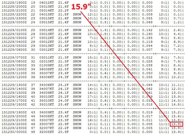
On The Upper End.
No, I don't think we'll wind up with 16" of snow, but just in case the
planets align I want to be on record showing NAM guidance (using the
Cobb method to tabulate snowfall totals). The snow/rain ratio is
forecast to be 12/1 to 9/1. With total liquid amounts forecast to be
1.39" that equates to over 15" of snow. Possible, but events will
probably conspire amounts from getting this high. But 10" or 12" is
looking more plausible, even likely. Source: Iowa State University.
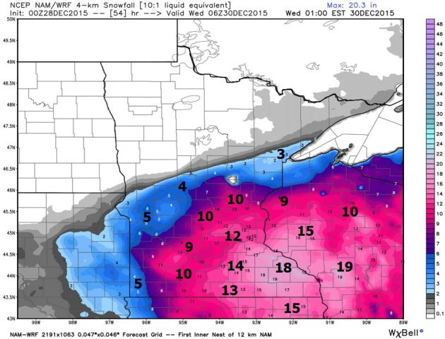
 Very Plowable
.
I hesitate to use the term, but this storm may border on crippling,
especially from eastern Iowa into southeastern Minnesota and central
Wisconsin. The combination of moderate snow and moderate drifting will
create white-out conditions tonight and a portion of Tuesday, making
travel very dangerous. NOAA NAM snowfall guidance courtesy of
WeatherBell.
 Significant Model Spread
.
I'd really like to see the models come into closer alignment and
agreement; at the low end 3-4" (GFS solution). At the upper end: 12-16"
(which I doubt, but I still can't rule this out since it's based on the
latest 00z guidance). The local NWS office in Chanhassen is predicting
about 8" from this system. Enough to shovel and plow, with a 1 in 3
chance of crippling amounts over southeastern Minnesota. Source: Iowa
State University.
On The Other Hand.
Here is why meteorologists are lonely, troubled people. The models
never agree. You look for individual models to agree, run to run, and
(where possible) key weather models to agree amongst themselves -
looking for shifts and trends. WSI's RPM model keeps the heaviest
(10-14") amounts from near La Crosse to Oshkosh with closer to 6-8" for
the metro. Still significant, but not the blow-out numbers suggested by
NAM and WRF. Place your bets. We'll see snow, but final numbers are
still up in the air.
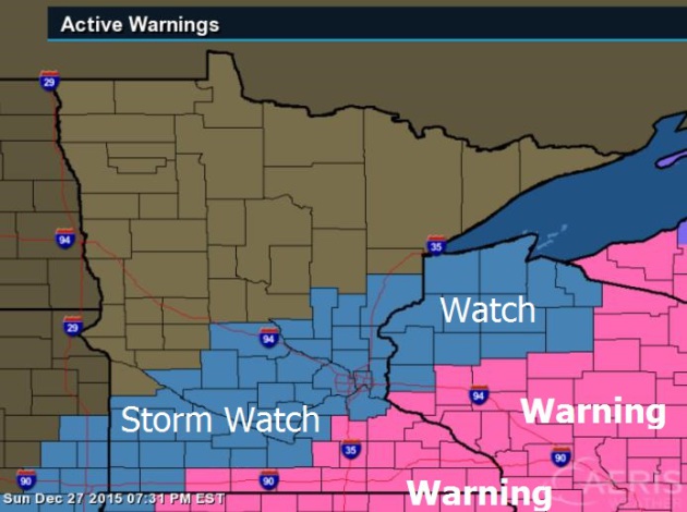
Winter Storm Watch.
A watch usually implies a high probability of 6" or more of snow over a
24 hour period. In this case we may get 6" of snow in the span of 4
hours or so early tonight. Warnings are in effect as close as Red Wing
and Rochester, where amounts may wind up being as high as 8-12" by the
time snow tapers on Tuesday.
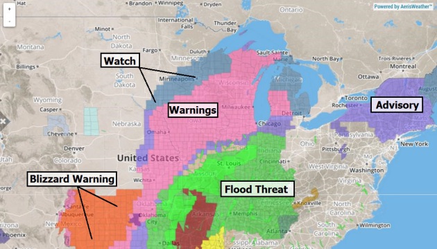
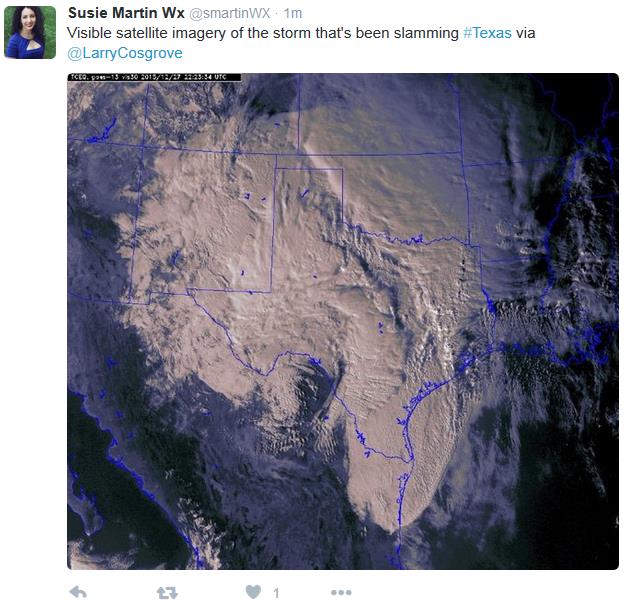
An Expansive Storm Threat.
Here are the latest (NOAA) watches, warnings and advisories - the same
storm that spawned blizzard conditions from New Mexico into the Texas
and Oklahoma Panhandle and tornadoes near Dallas will surge north,
spreading a shield of heavy snow across the Plains into the Upper
Midwest and portions of the Great Lakes. Map: Aeris Enterprise.
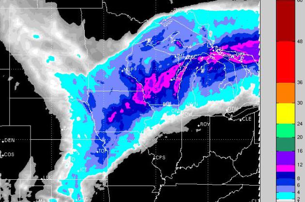
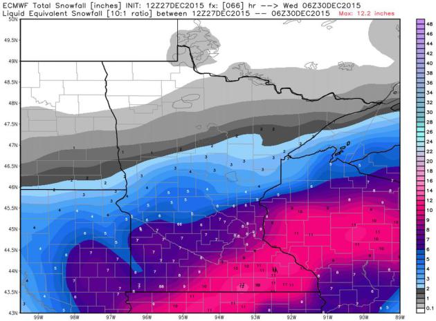
ECMWF Snowfall Estimates.
This is from 12z Sunday - I'll post the latest (00z) snowfall forecast
as soon as it's available. The "Euro" has been consistent, printing out
5-8" for the metro, with more over southeastern Minnesota, enough cold
air in place for all snow. A sharp deformation zone may imply a tight
snowfall gradient; probably plowable for St. Cloud and even Brainerd,
but little snow for Detroit Lakes, Bemidji and the Red River Valley as
the storm tracks from near the Quad Cities to Milwaukee. Based on the
latest WRF and NAM numbers I suspect the ECMWF (which has had the right
idea for 3 days now) may be a little on the light side with snowfall
totals. We'll see. Map: WeatherBell.
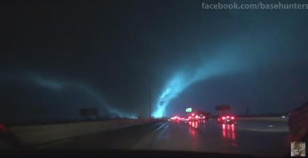
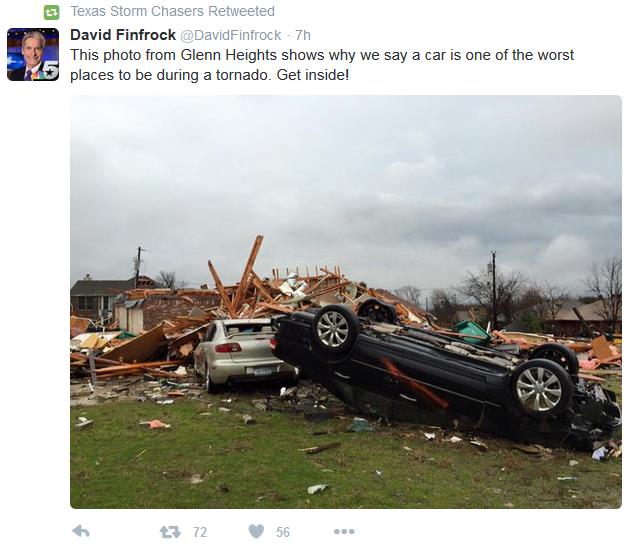
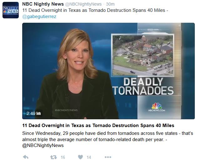
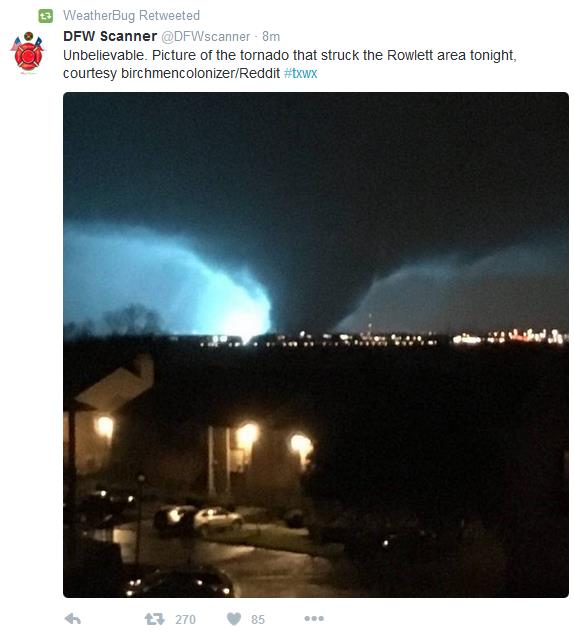
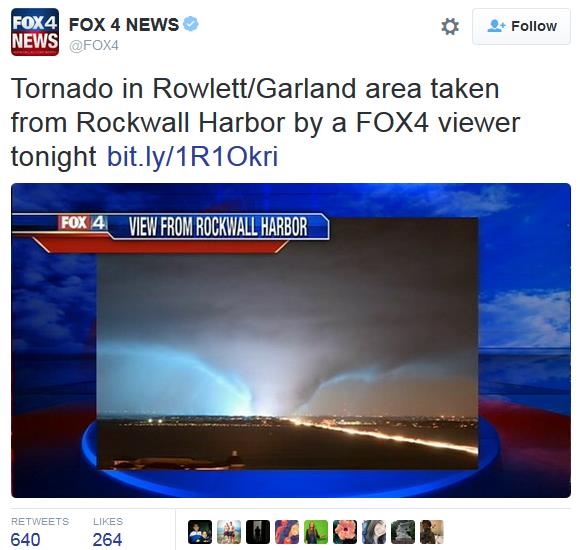
Video of Texas Killer Tornadoes. Basehunters has some amazing
YouTube footage
of the EF-4 tornado that swept across the eastern suburbs of Dallas
Saturday evening; part of the same intense storm pushing snow northward
toward Minnesota and Wisconsin. Basehunters writes: "
A large
nighttime tornado roars across I-30 in Rowlett, TX causing numerous
power flashes and explosions. Tornado continues northward across Lavon
Lake and causes damage in Copeville, TX, continuing north along TX-78."
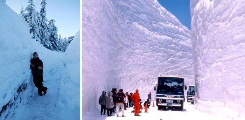
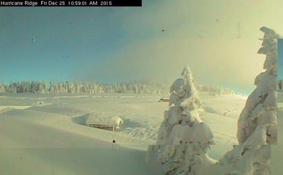
No Skiing Due To Too Much Snow? The Olympic Range west of Seattle has been hammered by snow; the risk of avalanches is high to extreme, as reported by
Olympic Peninsula Daily News: "
Hurricane
Ridge Ski and Snowboard Area will be closed Saturday because of too
much snow — more than 7 feet. However, extra ski days have been added
and the ski area will be open nearly all next week beginning Sunday. As
of this morning, the Hurricane Ridge Road was expected to open for
visitors at 9 a.m. Saturday, according to the Olympic National Park
information hotline. The lodge is closed on Christmas Day. The lodge is
open when the road is. Guided snowshoe tours, cross-country skiing and
other usual park activities are expected to open Saturday..."
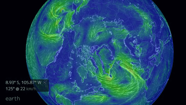
Warm Arctic Storm to Hurl Hurricane-Force Winds at UK and Iceland, Push Temperatures 72F Warmer than Average at North Pole. No wonder Santa is a little pissed - freakish weather is extending to the top of the world, according to Robert Scribbler: "We’ve
probably never seen weather like what’s being predicted for a vast
region stretching from the North Atlantic to the North Pole and on into
the broader Arctic this coming week. But it’s all in the forecast — an
Icelandic low that’s stronger than most hurricanes featuring a wind
field stretching over hundreds and hundreds of miles. One that taps warm
tropical air and hurls it all the way to the North Pole and beyond
during Winter time. And it all just reeks of a human-forced warming of
the Earth’s climate…
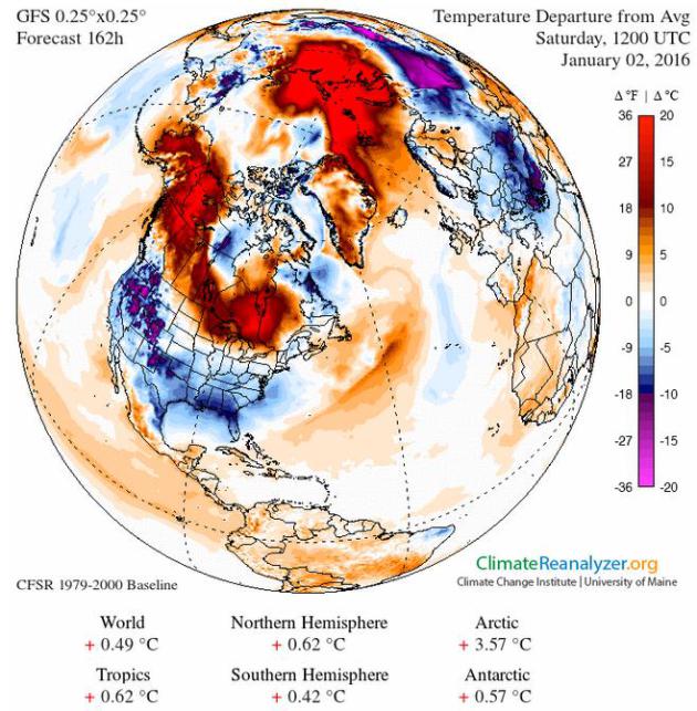
Unusual Warmth Unusually Far North.
Picking up on the previous post, check out the temperature anomalies
over much of the northern hemisphere, the GFS forecast for Saturday
morning, January 2. We've literally run out of colors near the North
Pole, where temperatures are forecast to climb above 32F.
Image source:
Climate Reanalyzer.
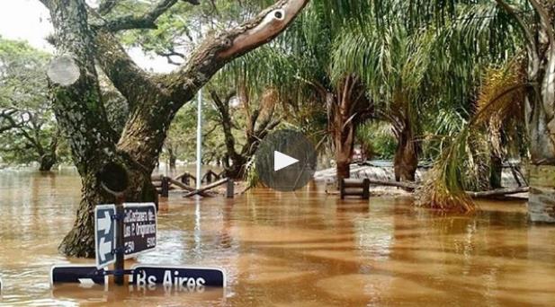
More Than 100,000 Flee El Nino Flooding in Paraguay, Argentina, Brazil and Uruguay.
Parts of South America are being hammered by record flooding, which may
be a symptom of the unusual warmth in the Pacific; here's an excerpt
from The Guardian: "More than 100,000 people evacuated their homes in the bordering areas of Paraguay, Uruguay, Brazil and Argentina
due to severe flooding in the wake of heavy summer rains brought on by
El Niño, authorities said. The Paraguayan government declared a state of
emergency in Asunción and seven regions of the country. Several people
were killed by falling trees, local media reported. “[The flooding] was
directly influenced by the El Niño phenomenon which has intensified the
frequency and intensity of rains,” the national emergencies office said..."
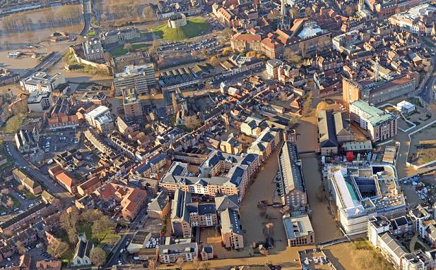
U.K. Floods: Aerial Footage Shows Streets in York Underwater. Extreme flooding is gripping much of Britain and the United Kingdom; here's an excerpt from
The Telegraph: "...
Soldiers
were mobilised this morning to join emergency services and mountain
rescue teams as they help people from their homes and bolster defences
with sand bags, while more than 20 roads across the city were closed
after being flooded. Around 3,500 properties are thought to be at risk
in the city, and rescue centres have been set up to help those affected.
Dozens of severe flood warnings remain in place in Yorkshire and the
North East, and engineers are working to restore power to more than
7,500 homes in Greater Manchester and Lancashire that have been left
without power..."
Photo credit above: "
Aerial view of York as flood waters cause misery for thousands "(Glen Minikin / SWNS)
Minneapolis, Victoria Take a Fresh Look at How to Deal with Major Flooding.
Yes, the rain is falling harder during the warm season and managing too
much (or too little) water will be a growing challenge in the years to
come. Here's an excerpt from
The Star Tribune: "
The
Twin Cities received record rainfall in 2014, but that was just the
start of what experts predict will be more extreme weather for the metro
area in the future. As a result, two cities in Hennepin and Carver
counties — one large, the other small — are taking a fresh look at ways
to manage flooding, as part of a federally funded study. The study,
conducted by the Minnehaha Creek Watershed District and the cities of
Minneapolis and Victoria, shows the various ways in which each city may
be prepared or not for the kind of heavy rain that fell in the summer of
2014..."
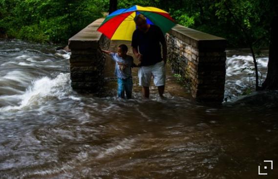
Photo credit above: Mark Vancleave. "
In June 2014, Craig Susag and his grandson crossed a flooded bridge over Minnehaha Creek in south Minneapolis".
Science Points to the Single Most Valuable Personality Trait. TIME has the results of an interesting study; here's a snippet of the secret sauce: "...
Conscientiousness
is the state of being thorough, careful, or vigilant; it implies a
desire to do a task well. Conscientiousness is also one trait of the
five-factor model of personality, and is manifested in characteristic
behaviors such as being efficient, organized, neat, and systematic. It
includes such elements as self-discipline, carefulness, thoroughness,
self-organization, deliberation (the tendency to think carefully before
acting), and need for achievement. Yeah, that sounds like a trait we all
respect. What’s amazing is just how predictive it is of so many things
we all desire..."
The Year of Good Things. Thanks to
Slate
for reminding us of all the good things that happened in 2015; one
good-news story for every day of the year. Here's the intro: "
Welcome to Slate’s
celebration of all the things that went right this year! Good news is
hard to find. One of journalism’s most important jobs is to call out
what’s wrong with the world so we know what to fix. But sometimes it’s
also a service to show what works, to admire people behaving honorably,
to appreciate signs of progress. In the interactive calendar above,
we’ve selected one story for each day of the year that was inspiring,
funny, or touching—stories of discoveries, artistic achievements, or
improvements in public health..."
TODAY:
Winter Storm Watch.
Dry morning as clouds thicken. PM snow develops, icy, snow-covered
roads by late afternoon and evening. Winds: NE 10-20. High: 25
TONIGHT: Snow, heavy at times. Near white-out conditions are possible. Low: 22
TUESDAY: Snow begins to taper - storm totals of 5-8" possible in the St. Cloud area, more over the Twin Cities and southeastern MN. Winds: N 8-13. High: 27
WEDNESDAY: Gray, few flurries in the air. Wake-up: 18. High: 23
NEW YEAR'S EVE: Mostly cloudy, feels like 5F. Wake-up: 10. High: 19
NEW YEAR'S DAY: Nippy New Year. Peeks of sun. Wake-up: 8. High: 25
SATURDAY: Partly sunny, closer to average. Winds: NW 7-12. Wake-up: 11. High: near 30
SUNDAY: Mix of clouds and sun, still dry. Winds: N 7-12. Wake-up: 18. High: 28
Climate Stories...
Anyone Else Worried About a Snowless December? Not
here in Minnesota, but much of the east coast has experienced a no-snow
December with green lawns and flowers in bloom. How much of this is El
Nino vs. planetary warming? Great question, but it's warming up, and the
symptoms are becoming harder to deny. It all depends on your point of
view, according to an interesting essay at
The Good Men Project; here's an excerpt: "...
The
answer, I suspect, is that we’ve reached a point where even our own
experiences can’t overcome our partisan biases. If you’re a global
warming denier, an unprecedented series of natural disasters won’t make
you budge, so it’s unlikely that uncharacteristically pleasant late
December weather would have that effect. If you support the scientific
evidence, you don’t need a snowless December to persuade you. As for the
people who don’t know or care about this issue, the chances are that
they’ll recognize the debate as so polarizing that they’ll just retain
their studied indifference for the sake of convenience. The net effect
is a social climate as dangerous as its meteorological counterpart. We
live in the era of anti-proof, in which people can rationalize away
facts that literally surround them because “proof” doesn’t count for
much anymore..."
"Hasn't The Climate Changed Before?" Yes
it has, in response to changes in Earth's orbit, planetary volcanoes
and solar radiation. But this time around we are the volcano; burning
fossil fuels has raised CO2 levels to 400 ppm, the highest value in at
least 800,000 years of ice core records from Greenland and Antarctica.
And the climate system is warming. Here's an excerpt from
Climate Reality Project: "
We’ve
all been there. Maybe you’re at a holiday party. The eggnog gets spiked
and the climate denier questions start up. Or perhaps you’re visiting
older relatives who ask what you’re up to these days. Then again, maybe
it’s yet another laughable Facebook post from that guy you met at your
cousin’s birthday party. “Isn’t the climate is always changing? How do
we know it’s us? Are we really so powerful that we can affect the entire
atmosphere? Maybe it’s the sun. Or volcanoes. Or a natural
cycle.” These are some of climate deniers’ favorite ways to foster
doubt. Meanwhile, big polluters love these statements since they
effectively absolve them of all responsibility for the detrimental
effects of dumping unlimited carbon pollution into our atmosphere..."
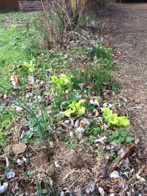
Climate Change has Changed My Backyard (and yours). 70s
and 80s in recent days of the east coast; flowers and trees are
blooming, and at least one resident of the Washington D.C. area finds
the weather surreal and unsettling. Here's an excerpt at
getenergysmart.com: "...
Daily
life is a form of cognitive dissonance. Physically, these warm
temperatures are a joy. Bike riding and walking with t-shirts, having
windows open for fresh air, not having to be bundled up with heavy
winter clothing. Yet … this is beyond bizarre, the changed backyard is
ominous to the extent of ‘climate changed’ rather than ‘the climate will
change’. In the past ‘normal’, roses from the garden aren’t supplying
cut flowers for the household at the end of the year. Wild lettuce
never provided a New Year’s day salad...."
How Bad of a Greenhouse Gas is Methane? And are we adequately accounting for all the man-made sources of methane? Here's an excerpt from
Scientific American: "...
At
issue is the global warming potential (GWP), a number that allows
experts to compare methane with its better-known cousin, carbon dioxide.
While CO2 persists in the atmosphere for centuries, or even millennia,
methane warms the planet on steroids for a decade or two before decaying
to CO2. In those short decades, methane warms the planet by 86 times as
much as CO2, according to the Intergovernmental Panel on Climate
Change. But policymakers typically ignore methane's warming potential
over 20 years (GWP20) when assembling a nation's emissions inventory..."
U.N. Chief: Bush Deserves Credit for Climate Change "Success". Here's an excerpt from
TheHill: "
President
George W. Bush deserves credit for kickstarting talks that led to a
landmark international agreement on climate change, according to U.N.
Secretary-General Ban Ki-Moon. Ban pointed to a 2007 U.N. climate
conference in Bali, when the United States pulled an about-face and
agreed to enter negotiations on a new global treaty to curb greenhouse
gas emissions. The secretary-general told the Associated Press
he still feels "very much grateful" to Bush. "That was the beginning of
our success," Ban said in an interview published Saturday..."
Photo credit above: "
Former
President W. George Bush, left, sits with his wife Laura Bush in the
stands during an NCAA college basketball game between Sam Houston State
and SMU Saturday, Nov. 14, 2015, in Dallas." (AP Photo/LM Otero)
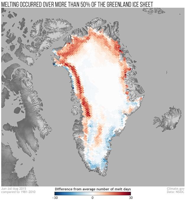
Surface Melting Affected More Than Half of Greenland's Ice Sheet in 2015. NOAA's
climate.gov has an update; here's an excerpt: "...
Adapted
from the Arctic Report Card: Update for 2015, this map shows the number
of melt days in June, July, and August 2015 compared to the 1981–2010
average. Areas that experienced a greater-than-normal number of melt
days appear in shades red. Areas that experienced a lower-than-normal
number of melt days appear in shades of blue. The melt season was up to
30 to 40 days longer than average in western, northwestern, and
northeastern Greenland, but was close to or below average elsewhere on
the ice sheet. On July 4, 2015, melt area extended over more than half
of the Greenland Ice Sheet for the first time since July 2012. For 52
days of the 90-day melt season, melt area exceeded the 1981–2010 average.."


No comments:
Post a Comment