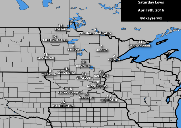
Record Cold Start In Parts Of The State Saturday
Many
of you probably reached for your jacket Saturday morning as you were
heading out the door to some pretty chilly conditions for this time of
year. The low got down to 20 in the Twin Cities, which was five degrees
shy of the record set in 1997. However, there were places across the
state that did see record lows Saturday morning:
- St. Cloud saw a low of 13, breaking the previous record of 14 in 1997 and 1960.
- Duluth saw a low of 2, breaking the previous record of 6 in 2007.
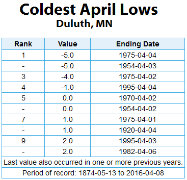
The
low of 2 Saturday morning in Duluth tied for the ninth coolest April
low on record, shared with a few other dates. The coldest April morning
in Duluth, though, occurred twice: a -5 that occurred on April 4th, 1975 and April 3rd, 1954.
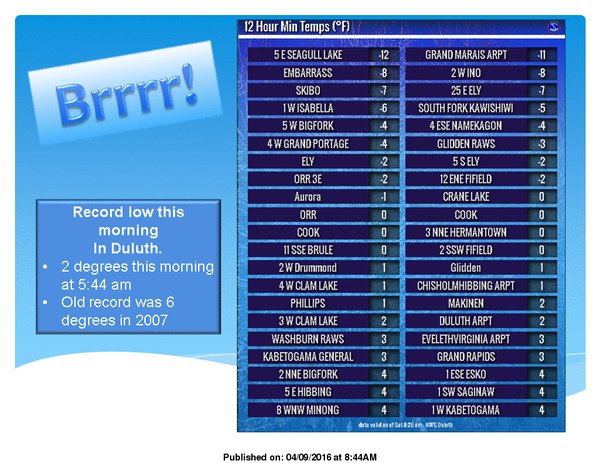
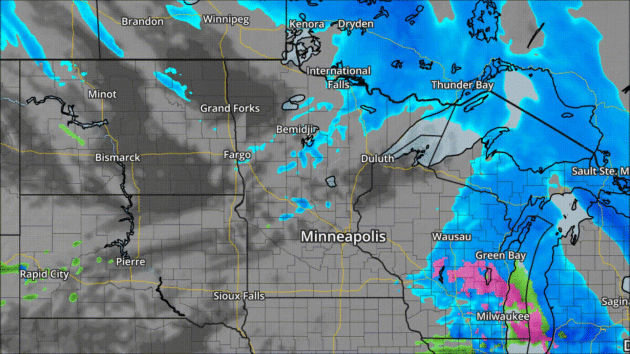
As
you would expect, though, there were even cooler spots on the map
versus where those record lows were set. You saw the low of -11 in Grand
Marais on the map above, but the coolest spot in the state was 5 miles
east of Seagull Lake which got down to -12. Even Embarrass didn't make
it that low - they only got down to -8.
_______________________________________________
Latest Twin Cities Snows On Record
After a half an inch of snow Friday in the Twin Cities as snow bursts/convective
snow showers moved through the metro, it made me wonder about when we
typically see the last "X" snowfall of the year. Unfortunately, we still
have over a month to go before we are in the clear of some of the
latest snows on record.
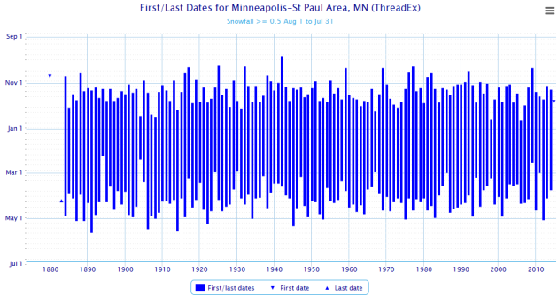
We'll
start off by looking at that amount we did see Friday, a half an inch.
First, the average day we see our last snowfall of at least that amount
is April 6th. So, if the snow we did see Friday was our last half inch
(or greater) daily total of the season, we'd be just about on average.
However, the latest half inch or greater snowfall on record was back in
1892 when it didn't occur until May 20th. Over the past few years, the last daily 0.5"+ has fallen on March 24th (2015), April 4th (2014), and May 3rd (2013).
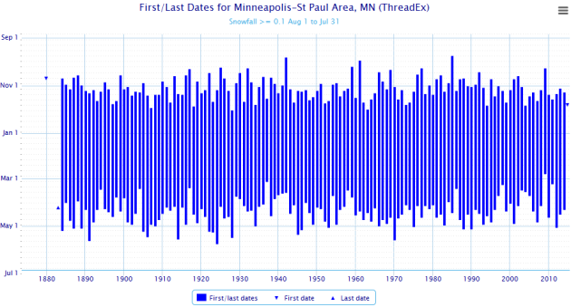
For
those who don't want any more accumulating snow, I do have some good
news. The date of the average last 0.1"+ snowfall in the Twin Cities is
April 14th - only a few short days away. We'll try to ignore the fact
that the latest date on record for the last 0.1"+ daily snowfall is May
24th, which occurred in 1925. Over the past few years, the last daily
0.1"+ snowfall has occurred on April 10th (2015), April 16th (2014) and
May 3rd (2013).
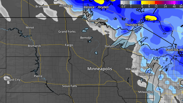
Current Snow Depth
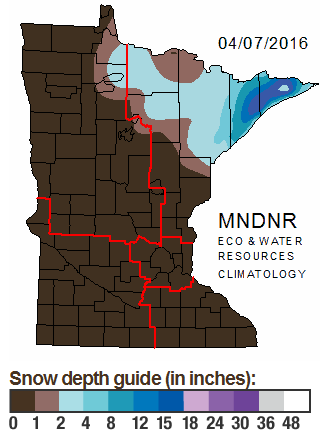
Every
Thursday the DNR updates snow depth across the state - and as you can
see the latest update looks pretty bare over much of Minnesota. If you
want snow, you have to head up to the Arrowhead, where 12-18" was still
on the ground in spots.
How
long may we continue to see snow depth maps being issued? Over the past
few years, the last snow depth map was issued by the DNR on the
following dates:
- 2014-2015: April 2
- 2013-2014: May 8
- 2012-2013: May 2
- 2011-2012: March 29
- 2010-2011: April 7
_______________________________________________
Monday: Twins Home Opener
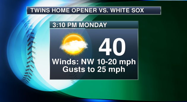
Are you ready for the Twins Home Opener? Be prepared to bundle up if heading out to the game
Monday at Target Field. I'm expecting a first pitch temperature of only
40 at 3:10 PM but with gusty northwest winds it'll feel more like the
upper 20s and low 30s throughout the game. Not the best baseball weather
in the world, but then again they are playing outside in the beginning
of April - just about anything can happen.
_______________________________________________
Food for Thought - And Good Reason to Smile
By: Paul Douglas
By: Paul Douglas
"People
were created to be loved. Things were created to be used. The reason
why the world is in chaos is because things are being loved and people
are being used."
Why
are we so angry? I have a theory. What worked in the 1950s isn't
working in the 2010s, when a tidal wave of factors is disrupting jobs -
in the blink of an eye.
Earn
a degree, then you're "set for life"? Hogwash. Most of us will have
multiple careers - and over a dozen jobs. We need to be ready for
opportunities that don't exist today. Embrace a new reality of lifetime
learning and retraining. We need new (online?) ways to remain viable and
employable deep into our golden years. I don't have the answer key, but
collectively, Minnesota does.
A stray shower this morning marks the leading edge of cooler air. Jackets early this week give way to 60s by Wednesday; 70F not out of the question by late week. An atmospheric jolt of adrenaline! Thunderclaps may interrupt spring euphoria by Friday; models hinting at a keep us mild next week.
Spring is always a sordid affair but I predict a risk of shorts in 3 days.
_______________________________________________
Extended Twin Cities Forecast
SUNDAY: Slow clearing, breezy. High 53. Low 31. Chance of Precipitation 20%. Wind NW 10-15 mph.
MONDAY: Plenty of sun, a cooler day. High 41. Low 27. Chance of Precipitation 0%. Wind NW 15-25 mph.
TUESDAY: Bright sunshine, less wind. High 47. Low 36. Chance of Precipitation 0%. Wind S 5-10 mph.
WEDNESDAY: Blue sky, spring fever returns. High 63. Low 47. Chance of Precipitation 0%. Wind S 10-20 mph.
THURSDAY: Intervals of sun, lukewarm breeze. High 65. Low 49. Chance of Precipitation 10%. Wind S 15-25 mph.
FRIDAY: Fading sun, isolated shower. High 64. Low 50. Chance of Precipitation 30%. Wind SE 10-20 mph.
SATURDAY: Mix of clouds and sun, still mild. High 66. Low 48. Chance of Precipitation 20%. Wind SE 10-15 mph.
_______________________________________________
This Day in Weather History
April 10th
1977: A record high of 86 is set at Redwood Falls.April 10th
_______________________________________________
Average Temperatures & Precipitation for Minneapolis
April 10th
April 10th
Average High: 55F (Record: 88F set in 1977)
Average Low: 35F (Record: 18F set in 1962)
Average Precipitation: 0.09" (Record: 1.33" set in 1883)
Average Snowfall: 0.1" (Record: 6.0" in 1891)
________________________________________________
Average Low: 35F (Record: 18F set in 1962)
Average Precipitation: 0.09" (Record: 1.33" set in 1883)
Average Snowfall: 0.1" (Record: 6.0" in 1891)
________________________________________________
Sunrise/Sunset Times for Minneapolis
April 10th
Sunrise: 6:36 AMApril 10th
Sunset: 7:53 PM
*Length Of Day: 13 hours, 16 minutes and 34 seconds
*Daylight Gained Since Yesterday: ~3mins & 3secs
*Next Sunrise That Is Before 6:30 AM: April 14th (6:29 am)
*Next Sunset That Is After 8 PM: April 16th (8:01 pm)
________________________________________________
Sunday Minnesota Weather Outlook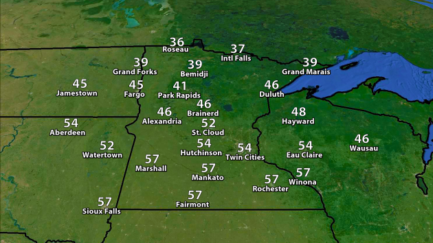
A
much warmer day is expected Sunday across Minnesota, with highs
reaching the 50s across the southern half of the state. 30s and 40s will
be common in the northern half, but in many places these highs will be at least a good ten degrees warmer versus where they were on Saturday.
Forecast clouds and precipitation every three hours between 7 AM Sunday and 7 AM Monday.
The day will start off mainly cloudy across the state, with the
potential of a few widely scattered rain showers across southern
Minnesota. Clearing skies will move in across southern Minnesota toward the afternoon hours. Across northern Minnesota, low pressure in Canada has the potential of sending some light rain/snow south across the border. The good news is that any accumulation will generally be light.
Not
much snow is expected across the state through Monday morning - the
best chance of accumulating snow being over far northeastern parts of
the state.
________________________________________________
National Weather Stories
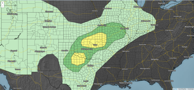
Severe
storms are expected to pop along a dryline Sunday afternoon over
western Texas, meanwhile a stationary front will likely allow storms to
form across parts of Oklahoma. Storms that do go severe on Sunday will
be capable of hail and wind.
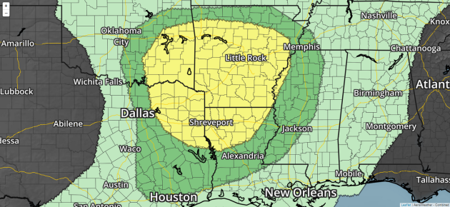
The
focus for severe storms will shift south on Monday, centering in and
around the Ark-La-Tex region. Storms capable of large hail, damaging
winds and even a few tornadoes will be possible. While only a Slight
Risk of severe weather was in effect as of posting, there is the
potential it could be upgraded in later outlooks.
________________________________________________
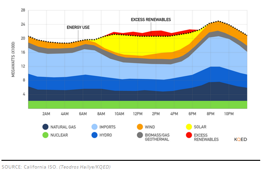
Image: Teodros Hailye/KQED
Too Much Solar Power? Now
this is something I wouldn't have expected - with so many solar farms
across California, there are days they are actually making too much
solar power. More from KQED: "Solar
energy records are falling left and right in California these days, as
the state steams ahead toward its ambitious renewable energy goals. But
the success of solar has brought about a hidden downside: on some
perfectly sunny days, solar farms are being told to turn off. That’s
because in the spring and fall, when Californians aren’t using much air
conditioning and demand for electricity is low, the surge of midday
solar power is more than the state can use."
________________________________________________
Thanks for checking in and have a great Sunday! Don't forget you can follow me on Twitter (@dkayserwx) or on Facebook (Meteorologist D.J. Kayser)!
- D.J. Kayser

No comments:
Post a Comment