53 F. average high on April 10.
58 F. high temperature on April 10, 2015.
April 11, 1929: An intense downpour occurs in Lynd, Minnesota (near Marshall), where 5.27 inches of rain would fall in 24 hours.
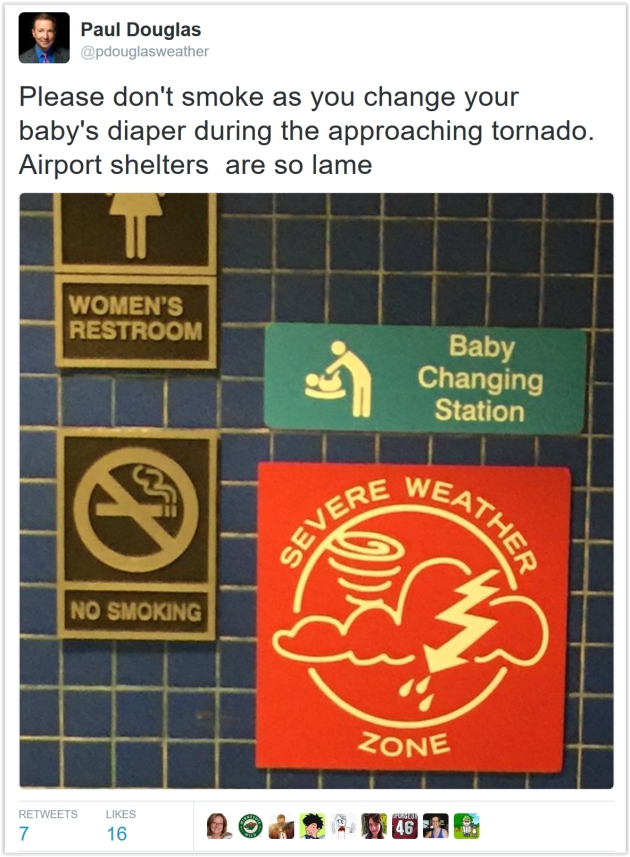
This is Severe Weather Awareness Week in Minnesota
Truth: you stand a better chance of sharing Sunday brunch with Prince than you do of seeing a devastating EF-4 tornado. Yet every year waves of severe thunderstorms sweep across Minnesota, sparking violent winds, large hail, flash flooding and lightning.
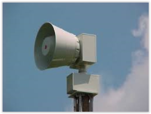
After 40 years of tracking storms here's my best advice: buy a NOAA Weather Radio. Nothing else will wake you up at 3 AM when severe storms are blowing through. Load up a few weather apps on your smartphone. For a few thousand dollars you can turn a closet into a reinforced, tornado-proof storm shelter. Don't rely on sirens (created for outdoor use only) or social media, where it's easy to get misinformation.
No big storms are in sight into next week as dry weather prevails. A cool wind today gives way to a lukewarm Pacific breeze 60s return by Wednesday with a shot at 70F by late week. I predict a raging rash of spring fever within 72 hours.
According to NOAA SPC Minnesota sees an average of 36 tornadoes every year. 24 were observed in 2015, but 2010 saw 145 twisters in the Gopher State; most in the USA.
Be a good Boy Scout. Be Prepared.

...According to the
National Weather Service, Minnesota experiences an average of 40
tornadoes per year. In 2012, 37 twisters touched down. A record was set
in 2010 with 104 tornadoes across the state.
Understanding
this threat and knowing what to do when a tornado is approaching can
save lives. Take advantage of Severe Weather Awareness Week to review
your own and your family's emergency procedures and
prepare for weather-related hazards. Each day of the week focuses on a
different weather safety topic:

- Tuesday — Severe Weather, Lightning and Hail
- Wednesday — Floods
- Thursday — Tornadoes (with statewide tornado drills)
- Friday — Extreme Heat
Weather Town Hall at Star Tribune on Wednesday. I'm
hoping you can join Vineeta Sawkar and me around midday Wednesday in
downtown Minneapolis to chat about the weather, severe storm technology
and broader trends; here's a link to more details: "...Join
chief meteorologist Paul Douglas and video news reporter Vineeta Sawkar
for a lively discussion about the warmer months ahead. Douglas
will offer a detailed forecast for spring/summer 2016, leaving plenty of
time for audience questions. The veteran newscasters will preside over a
round of Minnesota weather trivia. We'll be giving away free portable
umbrellas (while supplies last). And T-Rex Cookie will be there selling
weather-themed treats..."
- Store important documents in a safe location – Consider investing in a safe box to store your important documents, photos and other valuables.
- Create a home inventory – Keep an up-to-date inventory of all items in your home. Include photos of valuables such as electronics and jewelry. This may help speed up the claims process if damage occurs as a result of the storm.
- Review your insurance coverage – Contact your insurance carrier to find out if you're fully protected. Use your home inventory to help determine if you have purchased enough insurance.
- Pay attention to weather alerts – Be aware of weather alerts and updates. In the event that a tornado watch or tornado warning is issued, seek shelter immediately and follow any official instructions from local or national officials.
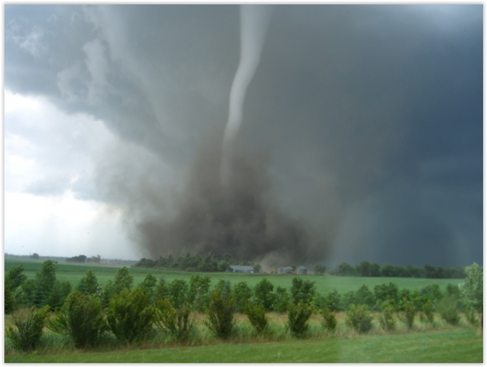
Photo credit:
Meteorologist Aaron Shafer, who snapped this near Albert Lea on June
16, 2010, the year Minnesota experienced 145 tornadoes, the most in the
nation.
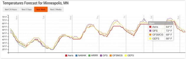
Welcome Warming Trend.
Models are pretty much singing the same tune, showing steady warming
into the weekend. GFS has the Twin Cities at 72F at 4 PM on Friday; 60s
are likely beginning Wednesday with warmth spilling into the weekend.
Graphic: NOAA and Aeris Enterprise.
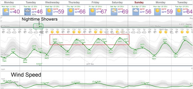
A Quiet Week.
I'm OK with that, btw. No complaints here. Today is the chilliest day
in sight; the approach of milder, Pacific air may set off a few showers
or sprinkles Tuesday night, but otherwise it's a dry forecast into early
next week - big storms continuing to detour well south of Minnesota.
Graphic: WeatherSpark.
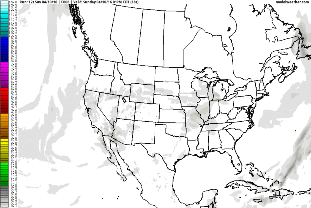
Rain Stays (Mostly) South and West.
Here is NOAA's estimate of 10-day rainfall amounts, based on GFS
guidance. The Gulf Coast may see some extreme 5-10"+ amounts, a decaying
frontal boundary pushing showers and T-showers across the Plains into
western Minnesota by Friday. Source: AerisWeather.
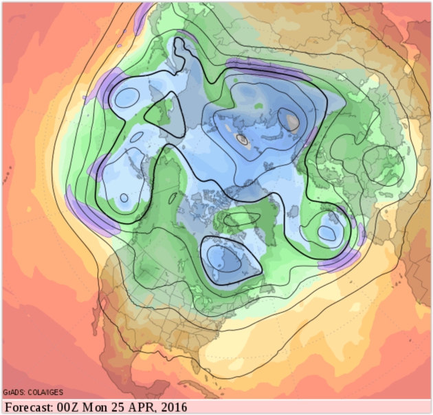
Relative Warmth Next 2 Weeks.
No more wintry flashbacks are brewing, if anything temperatures trend
above average again the next 1-2 weeks with a relatively mild, zonal,
west-to-east wind flow aloft keeping wind chills bottled up in Canada.
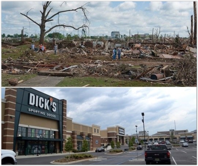
Tuscaloosa: 5 Years Later. AL.com
takes a look at the horrific tornado that hit Tuscaloosa on April 27,
2011, part of the biggest tornado swarm on record in the U.S.: "Wednesday,
April 27 will mark five years since an EF4 tornado ripped through and
destroyed 12.5 percent of the city in 2011. At least 53 people in
Tuscaloosa were killed in the storm. Inside the city limits, more than
5,300 homes were destroyed or severely damaged. Sixty-one percent of
those homes were rentals. More than 50 percent of those homes had median
incomes of $27,000 or less. Today we look look back at that day and the
city's recovery since and ahead to the continued path to rebuild the
rest of Tuscaloosa..."
Photo credit: "Photos of the Tuscaloosa's recovery progress in the areas most devastated by the EF4 tornado." (AL.com)

Photo credit above: "The High Roller is reflected in a puddle at the Linq in Las Vegas on Saturday, April 9, 2016." Brett Le Blanc/Las Vegas Review-Journal Follow @bleblancphoto.
* More details and perspective on the flooding around Las Vegas from The Weather Channel.
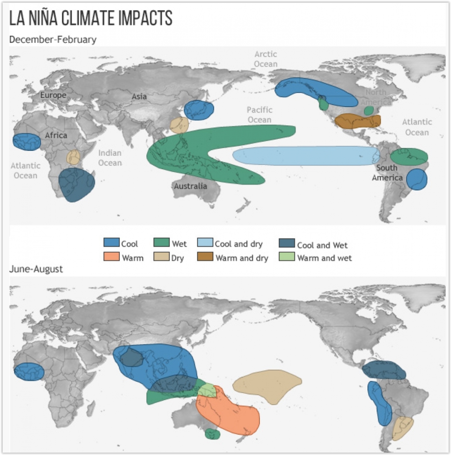
Will La Nina Follow One of the Strongest-Ever El Ninos? The odds are increasing, which (might) favor a more active hurricane season in the Atlantic, and a greater risk of drought for the Upper Midwest. Here's an excerpt from Climate Central: "...The Rossby waves usually disrupt the El Niño pattern about six months after it peaks, or, right about now. Indeed, forecasters have noted a cool down below the surface of the eastern tropical Pacific in recent weeks, though surface water temperatures are still firmly in El Niño territory. They will gradually follow the subsurface cool-off, though, likely reaching neutral territory by late spring. If a La Niña is in the offing, those waters should be cooling further by mid-summer, though, like El Niño, it wouldn’t peak until late fall or early winter. Right now Barnston puts the odds at slightly better than 50 percent that a La Niña does develop..." (Image credit: NOAA climate.gov).

Photo credit above: Volocopter VC200 (© e-volo, by Nikolay Kazakov).

TODAY: Brisk with a mix of sun and clouds. Feels like 20s. Winds: NW 15-25. High: near 40
MONDAY NIGHT: Clear and frosty. Low: 26
TUESDAY: Bright sun, feeling better. Winds: S 8-13. High: 47
WEDNESDAY: Early shower or sprinkle, then mild sun. Winds: S 10-20. Wake-up: 39. High: 60
THURSDAY: Partly sunny, feeling feverish. Winds: S 15-25. Wake-up: 46. High: 68
FRIDAY: Intervals of sun, take a comp day. Winds: S 15-25. Wake-up: 51. High: near 70
SATURDAY: Some sun, T-shower risk western MN. Winds: SE 10-20. Wake-up: 52. High: 67
SUNDAY: Isolated shower, a bit cooler. Winds: N 8-13. Wake-up: 49. High: 63
Climate Stories...
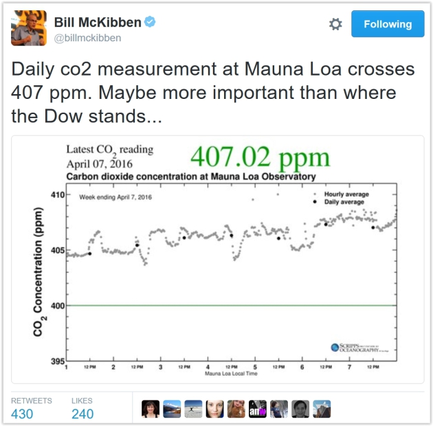
Climate-Related Death of Coral Around World Alarms Scientists. Here's a snippet from a New York Times article:
"...The damage off Kiritimati is part of a mass bleaching of coral
reefs around the world, only the third on record and possibly the worst
ever. Scientists believe that heat stress from multiple weather events
including the latest severe El Niño, compounded by climate change,
has threatened more than a third of Earth’s coral reefs. Many may not
recover. Coral reefs are the crucial incubators of the ocean’s
ecosystem, providing food and shelter to a quarter of all marine
species, and they support fish stocks that feed more than one billion
people. They are made up of millions of tiny animals, called polyps,
that form symbiotic relationships with algae, which in turn capture
sunlight and carbon dioxide to make sugars that feed the polyps..."
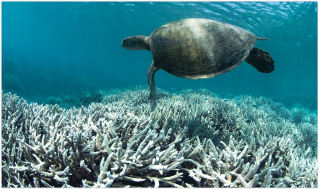
Photo credit above: "A turtle swimming over bleached coral near Heron Island, in the southern Great Barrier Reef." Credit XL Catlin Seaview Survey.
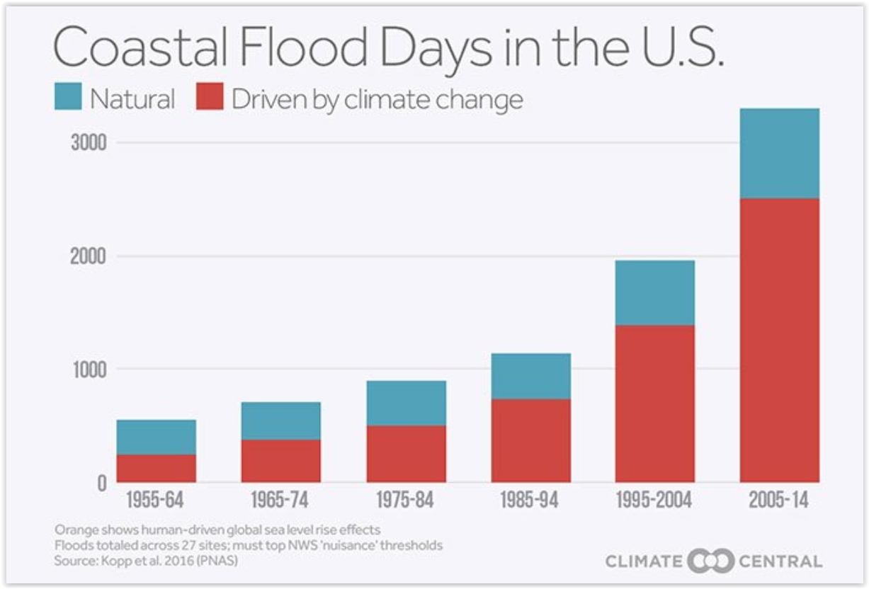
Oh Buoy, What's Happening With Sea-Level Rise? Here's an excerpt from a good summary from The Climate Reality Project: "...Carbon pollution from fossil fuel burning and industry is at an all-time high, and both atmospheric carbon dioxide levels and global temperatures have increased dramatically since the Industrial Revolution. Carbon pollution traps more and more heat in our atmosphere, and these warmer temperatures cause glaciers to melt and sea water to expand – leading to sea-level rise. Sea levels are rising faster than at any time in almost 3,000 years – and the reason why is clear: human-caused climate change..." (Graphic credit: Climate Central).
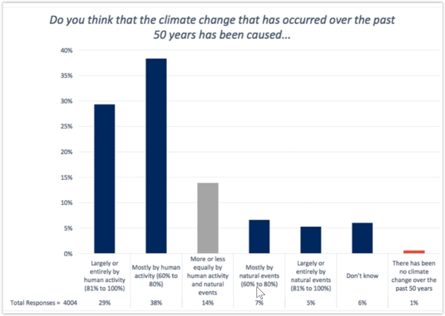
Graphic credit above: George Mason University, Center for Climate Change Communication.
No comments:
Post a Comment