68 F. high in the Twin Cities Sunday.
49 F. average high on April 3.
42 F. high on April 3, 2015.
April 5, 1999: Heavy snow falls over the Arrowhead, with 11 inches at Two Harbors.
April 5, 1929: A tornado cuts a path from Lake Minnetonka through North Minneapolis and leaves six dead.
Canadian Leakage - Another Warm Front Next Weekend
Here's my annual public service for brides planning outdoor weddings this summer: rent the tent. If you don't - all bets are off.
Here's my annual public service for brides planning outdoor weddings this summer: rent the tent. If you don't - all bets are off.
People
become illogical and borderline pathological when it comes to weddings
and the weather. My oldest son was married in late October. Mercifully
the sun came out for a few hours as the mercury hit 50F. Afterwards, in
the parking lot, a woman came up and said "I noticed you had a perfect
fall day for YOUR wedding. It POURED on my daughter's wedding yesterday.
How does that make you feel?" She was only half-joking. "Lucky?" I
said. Oy vey. The perils of trying to predict the weather.
After a stunning Sunday
Canadian air burbles south again today; temperatures much of the week a
few degrees below average. Under a scrappy sky that resembles late
October at times showery rains are likely Tuesday into Thursday.
The thrust of the cold air is Great Lakes and New England; Minnesota
just enjoys a glancing blow of brisk with 50s next weekend.
Outdoor events?
Hope for the best, but plan for worst-case. Just remember, Mother Nature doesn't owe you any favors.
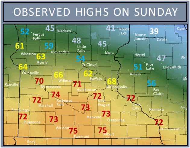
Perfectly Normal - For May 11.
Sunday was remarkable, even nicer than expected with upper 60s and a
few low 70s across the metro - but 40s over far northern suburbs - 30s
closer to Spooner. Map: Twin Cities National Weather Service.
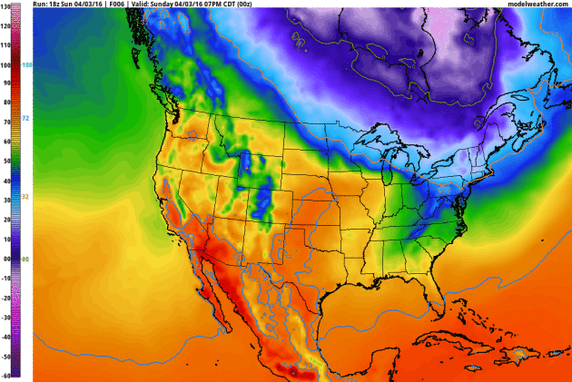
Cool Bias Next 10 Days.
After warming up to 68F Sunday (significantly milder than expected or
predicted - although I heard few complaints) Canada returns for an
encore performance much of this week and next with temperatures running a
few degrees below average. Although the core of the cold air is heading
toward the Great Lakes and New England I see a streak of 40s (with a
few 50s thrown in) into early next week. 2-meter (GFS) predicted
temperatures: NOAA and AerisWeather.
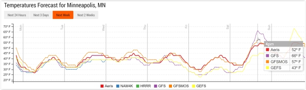
Mostly 40s - Weekend Warming.
Models are in fairly good agreement keeping it cool this week, an
upward blip into the 50s, possibly 60F by next Saturday. Source: Aeris
Enterprise.
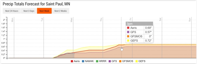
Showery Rains Metro Area - Mix Up North.
Models hint at over half an inch of rain by Thursday; the best chance
of showery rains coming on Tuesday. Now that it's April the maps look
like mid-March.
Sloppy Week.
Good news for your lawn and budding plants and trees. Another free
watering is on the way; the best chance of half inch precipitation
amounts north of MSP, where precipitation may fall as a mix - even a
couple inches of slushy snow. 12 KM NAM guidance: NOAA and AerisWeather.
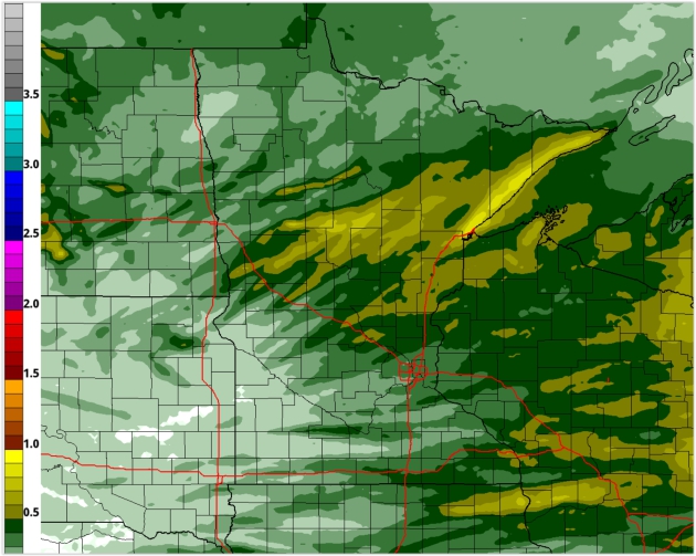
Echoes of The March We Never Had.
Back to the future - folks living in Duluth and the Minnesota Arrowhead
will enjoy a few inches of slushy snow by midweek. With a high sun
angle and UV radiation penetrating thick stratus roads should be
mostly-wet during the day, but potentially slippery after dark.
Warm(er) and Unsettled by Mid-April.
After a cool, damp start to the month temperatures should moderate a
bit within 1-2 weeks; more consistent 50s with a few 60s - even a
growing chance of T-storms by the third week of April.
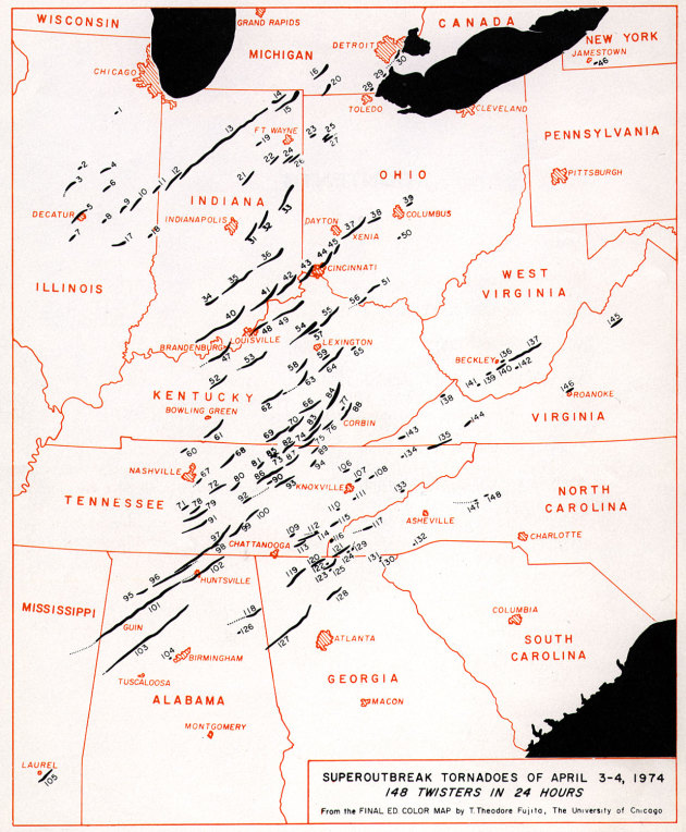
Graphic credit above: "Comparison of tornadoes F/EF3 or higher in 1974 and 2011." Chart by Kathryn Prociv.
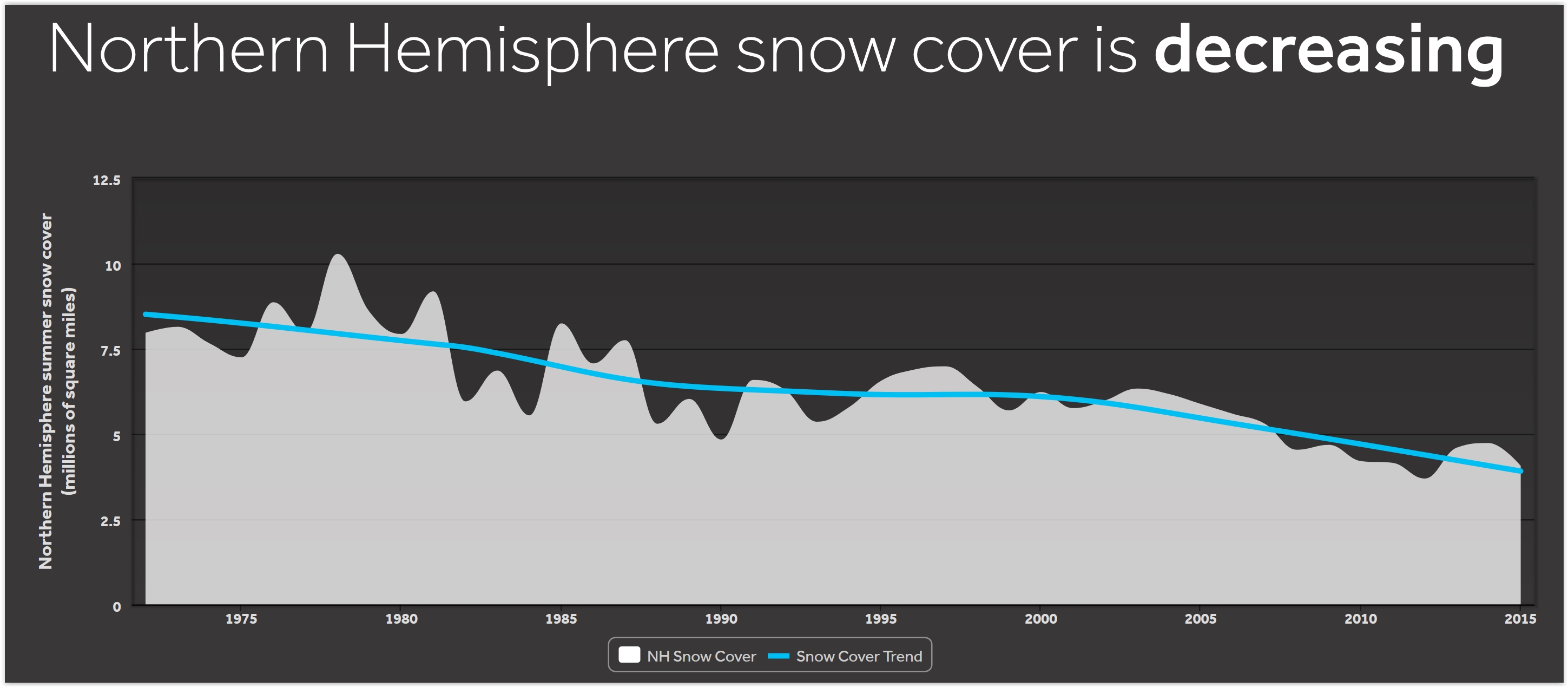
Northern Hemisphere Snowcover is Decreasing. No, you're not imagining it. Here's an excerpt from a post at WXshift: "Since
satellites started collecting data in the early 1970s, there has been a
trend toward less summer snow cover in the Northern Hemisphere. While
most people might think of the summer as beach time, snow still covers a
wide swath of land in the northern stretches of the globe. But over the
past 50 years, that snow cover has been receding from a peak of 10.28
million square miles set in 1979 to a record low 3.69 million square
miles set in 2013. Spring snow cover is also on the decline and this
reduced snow cover is consistent with rising temperatures driving
increased snowmelt..."
Even in a Warming World, It Will Still Snow Somewhere.
God help us if it stops snowing durinig the winter; but snowfall
patterns are becoming more sparse and erratic - continuous snow on the
ground from October to March is no longer a given, even in Minnesota.
Here's an excerpt from The New York Times: "...Adam H. Sobel, a climate scientist at Columbia University who wrote a recent book on Hurricane Sandy
and extreme weather, reminds people to make sure to differentiate
between weather and climate. If you really want to know what is going on
with climate change, he said, look at the long-term averages over large
areas. Do not be fooled by short-term weather fluctuations, or by
distractions like snowballs..."
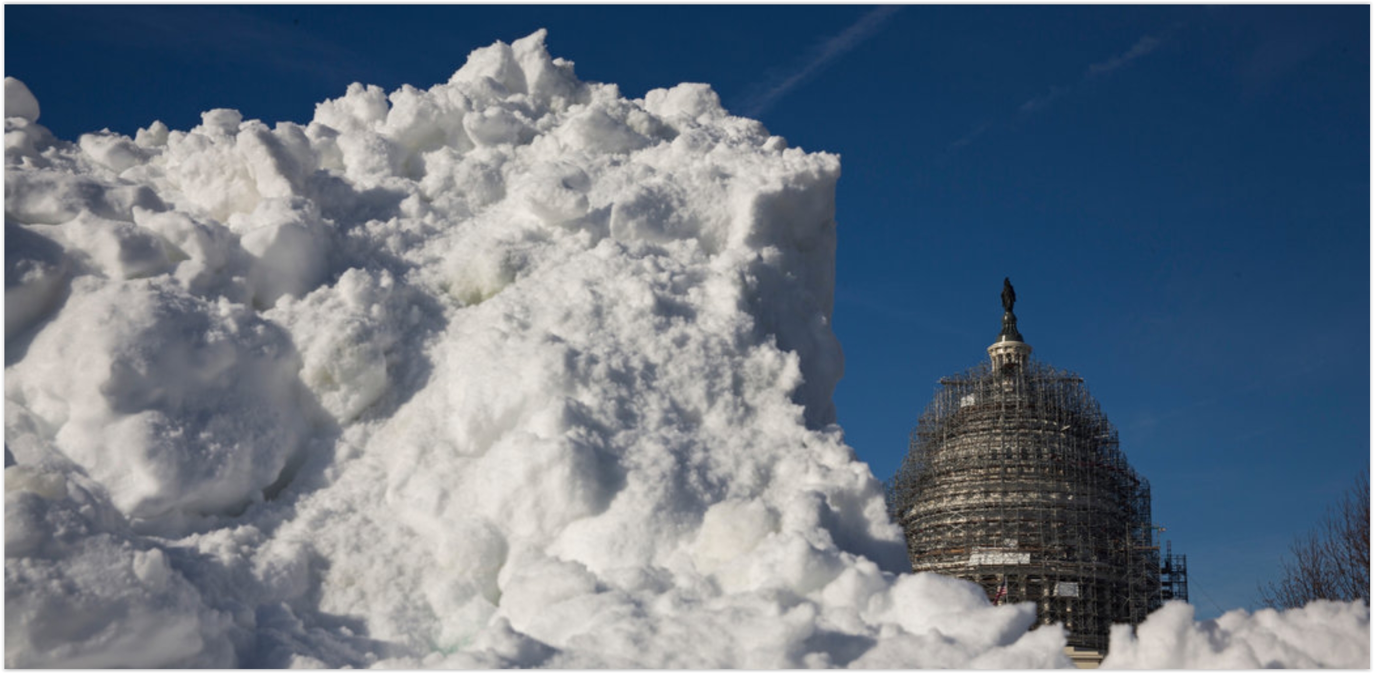
Photo credit above: "If
you really want to know what is going on with climate change, climate
scientists urge looking at long-term averages over large areas. A snow
storm on Capitol Hill does not mean climate change is not happening." Credit Drew Angerer for The New York Times.
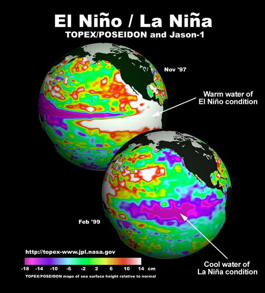
Will La Nina Affect the 2016 Presidential Election?
It's a generalization, but La Nina cool phases in the Pacific tend to
favor drought and more numerous hurricanes. Dr. Mashall Shepherd takes a
look at Forbes; here's an excerpt: "...Given
the timing of a possible La Niña onset, it is not unreasonable to ask
the question, “Could it affect the upcoming U.S. Presidential election
in November?” This question is not as far fetched as you may think.
Published research from the University of Georgia
found that Hurricane Sandy may have affected voter turnout in some
Northeast states. Previous studies have also indicated that extreme
temperatures, rainfall or snowfall can suppress turnout among sporadic
or less-intense voters, which often tend to vote Democrat. While some studies suggest adverse weather conditions favor Republicans, other studies have also contradicted this premise. It is clear that weather does have some effect..."
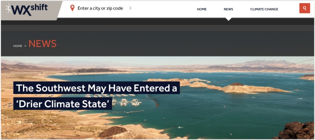
The Southwest May Have Entered a "Drier Climate State". Here's a good summary of new research findings, courtesy of WXshift: "The Southwest is already the most arid part of the U.S. Now new research indicates it’s becoming even more dry as wet weather patterns, quite literally, dry up. The change could herald a pattern shift and raises the specter of megadrought in the region. “We see a very intense trend in the Southwest,” Andreas Prein, a postdoctoral researcher at the National Corporation for Atmospheric Research, said. “The Southwest might already have drifted into a drier climate state...”

Photo credit above: "The American robin, a familiar species across much of the continental United States, has declined in some southern states, such as Mississippi and Louisiana, but increased in north-central states, such as the Dakotas." (U.S. Fish and Wildlife Service)
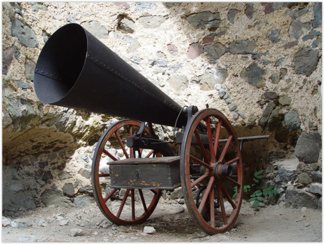
Hail Cannons, the Devices that Supposedly Blast Away Bad Weather. I'd like to order a dozen, please. Here's a snippet from Atlas Obscura: "Prior
to the 1890s, humans attempted to modify the weather using rain dances,
prayers, incantations, and bell ringing. Then came an exciting new form
of weather modification technology: the hail cannon. Employed to prevent or reduce hail’s deadly damage to crops, hail cannons can be traced back
to an Italian professor of mineralogy, who in 1880 raised the idea of
preventing hailstorm formation by injecting smoke particles into
thunderstorms via cannon..."
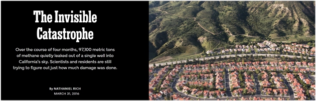
Image credit above: "A view of the neighborhood, Aliso Canyon and the methane wells (on the ridge)." Credit Ewan Telford for The New York Times.
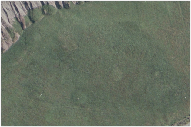
Image credit above: "An unprocessed satellite image of Point Rosee. Parcak and her team were alerted to the presence of an archaeological site here by almost imperceptible variations in the vegetation." (Courtesy Environmental Council of Newfoundland and Labrador)

Photo credit above: "Two sisters in their traditional, everyday, Lancaster County Amish attire." (Photo: Tessa Smucker).

TODAY: Partly sunny, cooler breeze. Winds: NW 7-12. High: 41
MONDAY NIGHT: Clouds increase, chilly. Low: 33
TUESDAY: Cool & damp, few showers likely. Winds: SE 15-30. High: 45
WEDNESDAY: Few instability showers possible. Winds: NW 10-20. Wake-up: 38. High: 46
THURSDAY: More showers, few flakes mixed in? Winds: NW 10-15. Wake-up: 36. High: 43
FRIDAY: Still chilly, sprinkles and flurries. Winds: N 10-15. Wake-up: 32. High: 41
SATURDAY: Partly sunny, breezy & milder. Winds: SE 10-20. Wake-up: 36. High: 58
SUNDAY: Clouds increase, few showers. Winds: SE 10-15. Wake-up: 43. High: 56
Climate Stories....
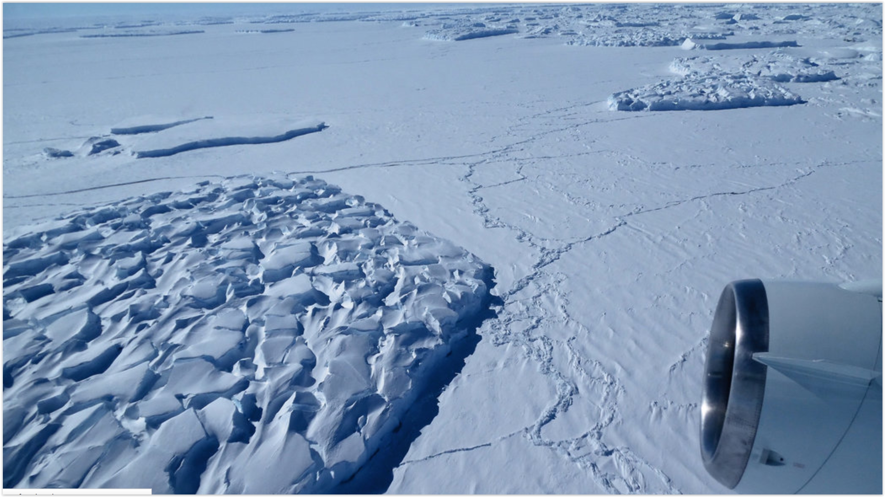
Climate Model Predicts West Antarctica Ice Sheet Could Melt Rapidly. In case you missed the Justin Gillis story at The New York Times; here's a clip: "For half a century, climate scientists have seen the West Antarctic
ice sheet, a remnant of the last ice age, as a sword of Damocles
hanging over human civilization. The great ice sheet, larger than
Mexico, is thought to be potentially vulnerable to disintegration from a
relatively small amount of global warming,
and capable of raising the sea level by 12 feet or more should it break
up. But researchers long assumed the worst effects would take hundreds —
if not thousands — of years to occur. Now, new research suggests the
disaster scenario could play out much sooner..."
Photo credit above: "A
view from a NASA airplane of large icebergs that have broken from the
calving side of Thwaites Glacier in Antarctica in November 2014. A
disaster scenario of West Antarctic ice sheet disintegration could occur
much sooner than previously thought, new research suggests." Credit Jim Yungel/NASA.
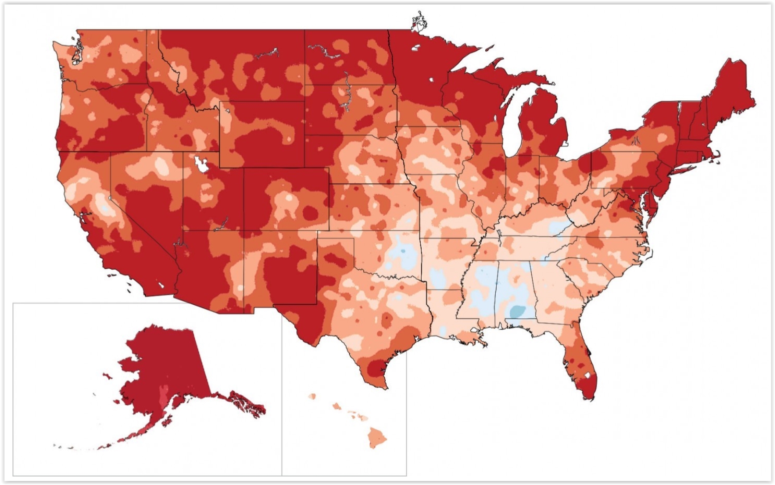
Map credit above: "Climate warming in U.S. from 1991-2012 compared to 1901-1960 average." (National Climate Assessment, 2014).
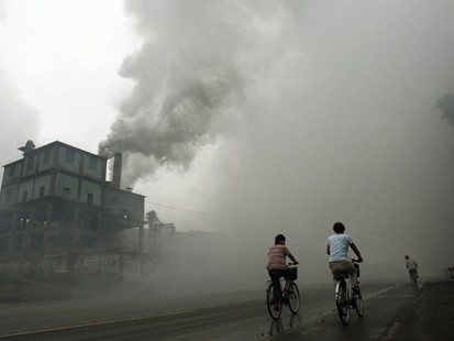
Its Hazy, But China's Carbon Emissions May Have Peaked. Here's a clip from a story at The New York Times: "...Now,
some researchers examining recent data from the slowing Chinese economy
are asking whether emissions of carbon dioxide, the main greenhouse
gas, are already falling in China — more than a decade earlier than
expected. If so, there could be important consequences. China’s success
could energize worldwide efforts to limit global warming
to 3.6 degrees Fahrenheit, or two degrees Celsius, above preindustrial
levels, considered a difficult mission but critical for forestalling
catastrophic environmental changes..."

No comments:
Post a Comment