Strong Winds On Saturday
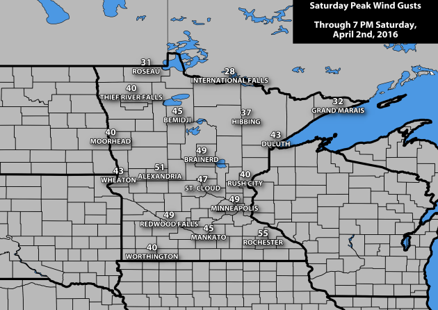
We saw a windy Saturday across the state, with numerous locations seeing gusts in the 40-50 mph range. Some
of the strongest gusts in places occurred before sunrise. Here is a list
of all the airport locations that saw a gust of 50 mph or higher on
Saturday:
Rochester - 55 mph (5:56 am)
St. Paul - 52 mph (7:09 am)
Morris - 52 mph (4:31 am)
Eden Prairie - 51 mph (4:32 am)
Slayton - 51 mph (5:42 am)
Owatonna - 51 mph (5:36 am)
Alexandria - 51 mph (2:33 am)
Jackson - 51 mph (6:53 am)
_______________________________________________
Saturday Snow Amounts
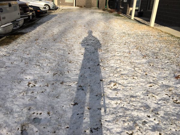
It
was also a snowy start to Saturday morning in some areas of the state.
This was my view as I woke up in the St. Cloud area Saturday - a coating
of snow on the ground, most of which had melted by midday.
The Twin Cities also got in on the action, officially
picking up a trace of snow Saturday. Those in St. Cloud were a little
luckier,
picking up 0.4" of snow.
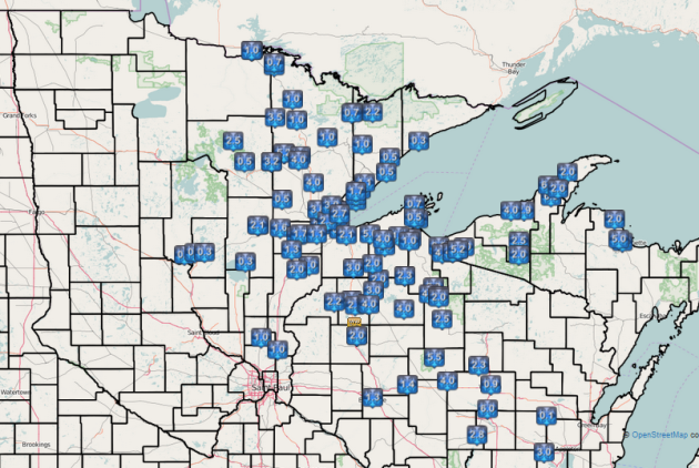
The
heaviest totals, though, were off to the north and east, with numerous
1-4" amounts common. The Duluth airport officially picked up 3.3" while
the heaviest total in the state was 5.5" recorded two miles west of
Leonidas in St. Louis County.
_______________________________________________
A Look At April Records
I'm
one who loves stats and climatology, so it only seems fitting that
while I am filling in today that we take a look at April records for the
Twin Cities, including highs, lows, precipitation and snow.
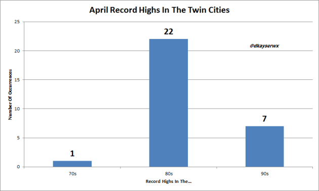
Since
it has been cool the past couple days, I thought I would start off with
April record highs. Most of the record highs fall within the 80-degree
range, with seven days of April seeing a record high in the 90s. The
"easiest" record to break during the month would be that one day in the 70-degree
range - a relatively cool 78 set back on the 2nd of 1981.
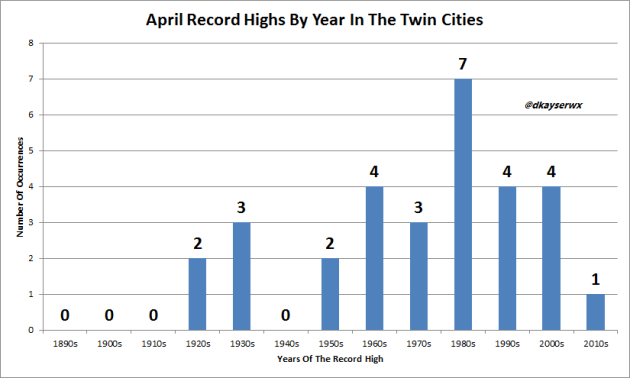
When
looking at when the record highs were set, only one has occurred within
the 2010s - the 84 degree day back on April Fools Day last year. Only
five of the current record highs on record occurred before 1950 - two in the 1920s
and three in the 1930s.
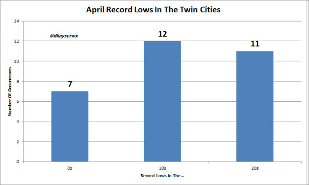
Turning
our attention to record lows, the good news is that we are out of the
subzero lows range - all of the April record lows are at/above zero. The
coldest April night we've ever had on record was 2, back on the 13th of
1962.
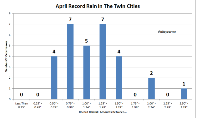
The
wettest April day ever was back on the 6th of 2006 when 2.58" was
recorded. Most of the records fall within the 0.50" to 1.75" range.
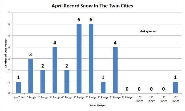
Even
though we are moving toward the warmer months of the year, we can still
see a wide range of snow during the month of April. The easiest snow
record to break is 0.4" of snow, set on the 24th of 1887. The heaviest
one day snow was back in 1983, when 13.6" fell on the 14th.
_______________________________________________
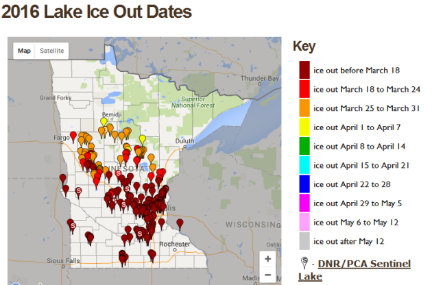
Ice out dates so far this spring. Image: Minnesota DNR.
Continued Early Ice Out Dates. We
continue to see lakes losing ice across the state, in many cases earlier
than average. According to climatologist Mark Seeley in his weekly WeatherTalk blog, "In
many cases lakes are losing their ice 2 to 3 weeks earlier than
average. For example Pearl Lake in Stearns County lost ice on March 15th
(reported by Sue Dudding) and this is the earliest of record, while
Lake George in Anoka County also lost ice cover on March 15th, a record
early date. Average ice-out date on Pearl Lake occurs on April 4th and
on Lake George it is April 6th."
_______________________________________________
Like Flicking on a Light-Switch: Instant Spring
By Paul Douglas
By Paul Douglas
Major
takeaways from the Severe Storm & Doppler Conference in Des Moines:
the new NWS dual-polarization Doppler upgrade is so sensitive it can
pick up a TDS, a "Tornado Debris Signature". A major tornado can loft debris 4-5 MILES into the sky. Tracking debris increases confidence that a tornado is, in fact, on the ground.
And suburban sprawl has increased the potential for tornado disasters. America's
population has doubled in the last 80 years. More suburbs, more
subdivisions, increase the likelihood that if a tornado DOES touch down
there will be damage and injury. We are inadvertently standing up more pins in lane 3 of the neighborhood bowling alley.
After
Saturday's blustery winds today should be a breath of fresh air with
50s, even a shot at 60F. Canada isn't done roughing us up: expect a family of clippers this week; each one dragging cool exhaust south of the border.
The best chance of rain comes Tuesday - by late week temperatures recover into the 50s. A reminder that spring is more theory than reality.
By mid-April we should see consistent 50s and 60s. In theory.
_______________________________________________
Extended Forecast for Minneapolis
SUNDAY: Sunny peeks, milder. High 58. Low 31. Chance of Precipitation: 20%. Wind SE 10-15 mph.
MONDAY: Sunnier and cooler. High 44. Low 33. Chance of Precipitation: 10%. Wind N 8-13 mph.
TUESDAY: Clouding up, showers likely. High 46. Low 38. Chance of Precipitation: 70%. Wind SE 15-25 mph.
WEDNESDAY: Blustery, cooler, lingering showers. High 42. Low 29. Chance of Precipitation: 50%. Wind NW 15-25 mph.
THURSDAY: Mostly cloudy, sprinkle or flurry. High 40. Low 27. Chance of Precipitation: 30%. Wind NW 10-20 mph.
FRIDAY: Plenty of sun, becoming breezy. High 43. Low 35. Chance of Precipitation: 10%. Wind S 10-15 mph.
SATURDAY: Intervals of sun, springy again. High 57. Low 34. Chance of Precipitation: 20%. Wind SW 10-15 mph.
1982: A sharp cold front causes the temperature at Lamberton in Redwood County to drop from 78 to 7 degrees. This 71 degree change in 24 hours is the maximum 24-hour temperature change in Minnesota.
1837: A snowstorm rages for four days at Ft. Snelling and dumps 9 inches.
Sunset: 7:44 PM
*Length Of Day: 12 hours, 54 minutes and 59 seconds
*Daylight Gained Since Yesterday: ~3mins & 6secs
*Next Sunrise That Is Before 6:30 AM: April 14th (6:29 am)
*Next Sunset That Is After 8 PM: April 16th (8:01 pm)
Sunday Minnesota Weather Outlook
MONDAY: Sunnier and cooler. High 44. Low 33. Chance of Precipitation: 10%. Wind N 8-13 mph.
TUESDAY: Clouding up, showers likely. High 46. Low 38. Chance of Precipitation: 70%. Wind SE 15-25 mph.
WEDNESDAY: Blustery, cooler, lingering showers. High 42. Low 29. Chance of Precipitation: 50%. Wind NW 15-25 mph.
THURSDAY: Mostly cloudy, sprinkle or flurry. High 40. Low 27. Chance of Precipitation: 30%. Wind NW 10-20 mph.
FRIDAY: Plenty of sun, becoming breezy. High 43. Low 35. Chance of Precipitation: 10%. Wind S 10-15 mph.
SATURDAY: Intervals of sun, springy again. High 57. Low 34. Chance of Precipitation: 20%. Wind SW 10-15 mph.
_______________________________________________
This Day in Weather History
April 3rd
1999: An ice storm hits Duluth and the Arrowhead. An 800 foot television tower in Duluth collapses due to the weight of the ice.April 3rd
1982: A sharp cold front causes the temperature at Lamberton in Redwood County to drop from 78 to 7 degrees. This 71 degree change in 24 hours is the maximum 24-hour temperature change in Minnesota.
1837: A snowstorm rages for four days at Ft. Snelling and dumps 9 inches.
_______________________________________________
Average Temperatures & Precipitation for Minneapolis
April 3rd
April 3rd
Average High: 51F (Record: 80F set in 1921)
Average Low: 32F (Record: 9F set in 1954)
Average Precipitation: 0.07" (Record: 0.84" set in 1974)
Average Snowfall: 0.1" (Record: 5.9" in 1974)
________________________________________________
Average Low: 32F (Record: 9F set in 1954)
Average Precipitation: 0.07" (Record: 0.84" set in 1974)
Average Snowfall: 0.1" (Record: 5.9" in 1974)
________________________________________________
Sunrise/Sunset Times for Minneapolis
April 3rd
Sunrise: 6:49 AMApril 3rd
Sunset: 7:44 PM
*Length Of Day: 12 hours, 54 minutes and 59 seconds
*Daylight Gained Since Yesterday: ~3mins & 6secs
*Next Sunrise That Is Before 6:30 AM: April 14th (6:29 am)
*Next Sunset That Is After 8 PM: April 16th (8:01 pm)
________________________________________________
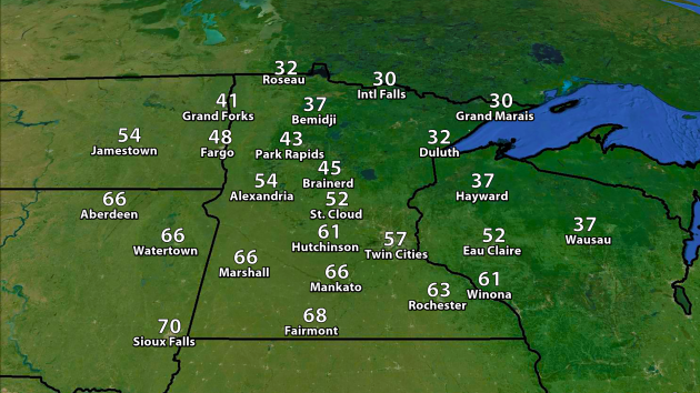
We
will be a state divided Sunday... Divided by temperature, that is.
Highs across southern Minnesota, squarely placed in a warm sector, will
make it into the 50s and 60s. There's even the chance some locations in
southwest Minnesota could make it into the low 70s. On the other half of
the dividing line, highs will only be in the 30s across northern
Minnesota.
On
the heels of the clipper that brought snow to northern Minnesota
Saturday, another will be moving through Sunday bringing the potential
of another 1-3" of snow to the region. Skies will be partly sunny across
southern Minnesota.
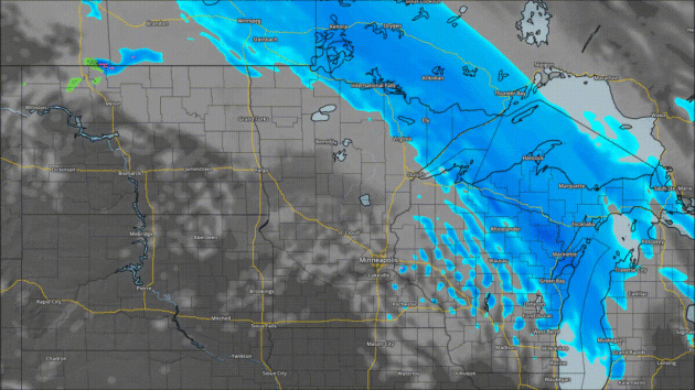
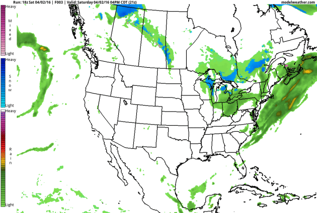
Here's
a look at the snowfall forecast through Monday at 7 AM - again, it
looks like 1-3" across parts of northern Minnesota, with potentially
some isolated 4-5" amounts.
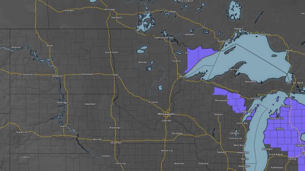
Due to that next batch of snow coming Sunday, Winter Weather Advisories have been put in place for parts of the Arrowhead.
________________________________________________
National Outlook
The
clipper that affected northern Minnesota Saturday will continue east
Sunday, bringing Buffalo and Rochester, NY the potential of 3-6" of
snow. It will also continue to bring windy weather with it, with the
potential of 50-60 mph wind gusts from Baltimore to Philadelphia, New
York City and Boston. Moisture will be moving off the Pacific as we head
into the beginning of the work week, bringing parts of the Pacific
Northwest rain. That moisture will travel east and bring us the chance of rain as we head toward the middle of the week.
________________________________________________
Thanks for checking in and have a great Sunday! Don't forget you can follow me on Twitter (@dkayserwx) or on Facebook (Meteorologist D.J. Kayser)!
- D.J. Kayser

No comments:
Post a Comment