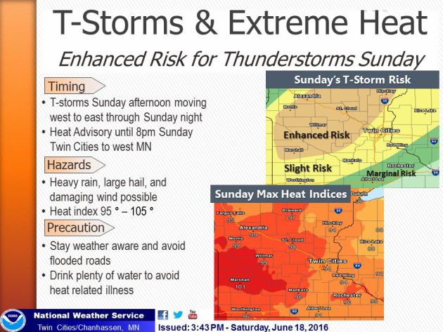
"Use caution during outdoor Father's Day activities! Expecting uncomfortable weather. Hot temperatures plus humidity will make it feel like 95-105°. Sunday afternoon enhanced risk for widespread thunderstorms. When thunder roars, go indoors!"
Rainbow Weather
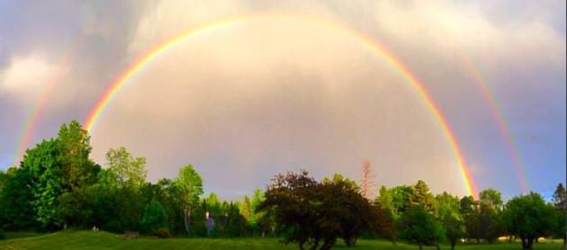
WOW! Thanks to Rien Schlecht for this incredible rainbow picture! She said it was the most vibrant one she's ever seen! Looks pretty spectacular Rien! Thank you for sharing.
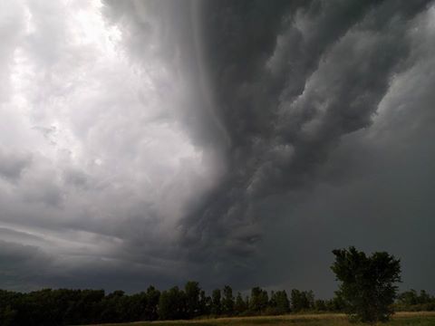
Outflow Near Kingston, MN
Thanks
to Michael Stanga for this neat picture from near Kingston, MN Friday
evening. This was from the same group of storms that started in eastern
ND on Thursday and pushed into NW Minnesota Friday morning and
eventually into SW Minnesota by Friday evening.
...HOT AND HUMID WEATHER SUNDAY...

.A SEASONABLY WARM AIRMASS WILL MOVE ACROSS THE REGION AND BRING
HEAT INDICES OF 95 TO 105 DEGREES ACROSS WESTERN AND CENTRAL MN.
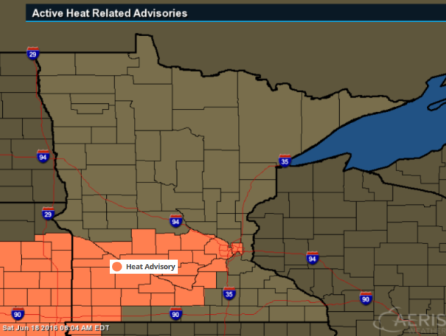
...HEAT ADVISORY IN EFFECT FROM 1 PM TO 8 PM CDT SUNDAY...

THE NATIONAL WEATHER SERVICE IN TWIN CITIES/CHANHASSEN HAS ISSUED
A HEAT ADVISORY...WHICH IS IN EFFECT FROM 1 PM TO 8 PM CDT
SUNDAY.

* TEMPERATURE...AIR TEMPERATURES 90 TO 95. HEAT INDICES 95 TO 105.

* IMPACTS...HEAT RELATED ILLNESS IS POSSIBLE IF PRECAUTIONS ARE
  NOT TAKEN.
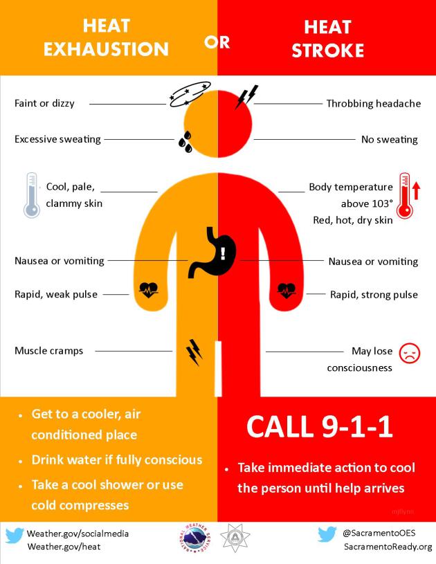
During extremely hot and humid weather, your body's ability to cool itself is challenged. When the body heats too rapidly to cool itself properly, or when too much fluid or salt is lost through dehydration or sweating, body temperature rises and you or someone you care about may experience a heat-related illness. It is important to know the symptoms of excessive heat exposure and the appropriate responses. The Centers for Disease Control and Prevention provides a list of warning signs and symptoms of heat illness, and recommended first aid steps.
See more from NOAA.gov HERE:
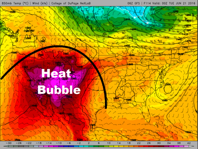
Excessive Heat Building in the Southwest
The
dome of hot weather will continue to build across the Southwestern part
of the nation with some spots nearing all-time record highs Sunday
and Monday.
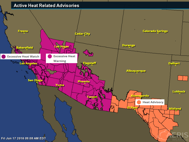
Excessive Heat Watches and Warnings
The
National Weather Service has issued a number of excessive heat watches
and warnings across the Southwest, which includes major cities like Los
Angeles, Las Vegas, Phoenix, Tucson and Yuma.
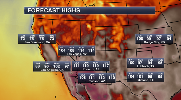
Potential High Temperatures & Stats
Phoenix, AZ
-
Highs will approach 120 on both Sunday and Monday. Phoenix has only had
a high of 120 or higher three times in their recorded history (since
1895).
- The last time Phoenix hit 120 or higher was back on July 28, 1995 when the thermometer hit 121.
- Whether the temperature touches 120 or not, record highs are likely. The current record high each day between Saturday and Tuesday is 115.
- The last time Phoenix hit 120 or higher was back on July 28, 1995 when the thermometer hit 121.
- Whether the temperature touches 120 or not, record highs are likely. The current record high each day between Saturday and Tuesday is 115.
Tucson, AZ
-
We are calling for a forecast high of 114 on Sunday. Only seven times
in Tucson recorded history (since 1894) has the city seen a high of 114
or higher – the last time occurring on July 28, 1995 when it also
reached 114.
- The all-time record in Tucson history is 117 set back on June 26, 1990.
- Record highs over the weekend and into next week are 113 Saturday, 112 Sunday, 110 Monday and 112 Tuesday.
- The all-time record in Tucson history is 117 set back on June 26, 1990.
- Record highs over the weekend and into next week are 113 Saturday, 112 Sunday, 110 Monday and 112 Tuesday.
Las Vegas, NV
-
Las Vegas is no stranger this type of higher heat in the forecast,
reaching a temperature of 115 or higher 55 times since 1937. The last
time Las Vegas saw a high of 115 or higher was back on July 2, 2013.
- The warmest high ever in Las Vegas history is 117 reached three times in their history. The most recent occurrence was back on June 30, 2013.
- Our forecast has Las Vegas reaching 114 both Monday and Tuesday next week.
- Record highs this weekend into next week are 115 Saturday, 114 Sunday, 113 Monday and 111 Tuesday.
Los Angeles, CA
- Even Los Angeles will get in on the heat this week into early next week, reaching at least the mid 90s Sunday through Tuesday.
- We could even see highs in downtown Los Angeles break the triple-digit mark next Monday. Down toward LAX, highs Monday will be near 90, which could break the record for the day of 86.
- We could even see highs in downtown Los Angeles break the triple-digit mark next Monday. Down toward LAX, highs Monday will be near 90, which could break the record for the day of 86.
(Image and stats courtesy: DJ Kayser @DKayserWX)
Heavy Rainfall Last Week
Here's
a look at rainfall from AM June 13th to AM June 18th. Note that there
were several locations that saw 1" to 2"+ amounts with some spots even
seeing 3" to 4"+. Here's an excerpt from Mark Seeley's Weather Talk on
the heavy rains last week.
The
warm and humid conditions of last weekend help set the stage for
numerous thunderstorms this week across much of the state. Recall that
the weather of last weekend produced widespread readings in the 90s F
around the state, including a record high of 98°F at Winnebago on the
11th, and a record high of 96°F at Lake Wilson on the same date. Many
observers also reported near record dew points in the 70s F, leading to
Heat Index readings over 100°F in many places. This represents a large
quantity of water vapor which does not allow the air to cool off much at
night. As a result, Tracy set a new record warm minimum temperature on
the 10th, with a reading of 73°F.
All of the water vapor in the atmosphere served as fuel for thunderstorms, which became widespread across the state over June 11-14. Over those 4 days many areas received from 2-4 inches of rain. A few highly localized amounts were even greater causing some short-lived flooding concerns. You can read more about the distribution of these storms at the Minnesota StateClimatology Office web site.
All of the water vapor in the atmosphere served as fuel for thunderstorms, which became widespread across the state over June 11-14. Over those 4 days many areas received from 2-4 inches of rain. A few highly localized amounts were even greater causing some short-lived flooding concerns. You can read more about the distribution of these storms at the Minnesota StateClimatology Office web site.
Some
climate stations reported new daily rainfall records as a result of
these thunderstorms. These included: on the 11th Lake City 2.03 inches;
on the 12th Thorhult 1.70 inches; on the 13th Eveleth 2.51", Dassel
3.19", Embarrass 1.96", and Stillwater 1.54"; on the 14th Amboy 2.00";
and on June 15th record values were reported for La Crescent 1.78",
Melrose 1.80", Caledonia 1.51", Harmony 2.07", Houston 2.83", Waseca
3.19", and Forest Lake 2.00".
The
strong thunderstorms on June 14th produced tornadoes in Pipestone,
Traverse, Big Stone, Le Sueur, and Blue Earth Counties. All were
relatively short-lived and produced relatively little damage. Very
strong winds up to 60mph were also reported from portions of Nobles,
Jackson, Cottonwood, Brown, and Watonwan Counties.
As a result of the rainy week, many climate stations are already reporting total monthly rainfall that exceeds the June normal. This continues a recent climate trend for June, as 15 of the most recent Junes have been normal or wetter than normal on a statewide basis.
As a result of the rainy week, many climate stations are already reporting total monthly rainfall that exceeds the June normal. This continues a recent climate trend for June, as 15 of the most recent Junes have been normal or wetter than normal on a statewide basis.

SHEAR WILL BECOME VERY SUPPORTIVE OF
   SUPERCELLS -- AND THUS A FEW INTENSE CELLS CAPABLE OF PRODUCING VERY
   LARGE HAIL AND LOCALLY DAMAGING WINDS ARE EXPECTED TO EVOLVE BY LATE
   AFTERNOON/EARLY EVENING.
By Todd Nelson, filling in for Douglas
I have good memories about my late father today. He always enjoyed sitting in a lawn chair on a hot summer day listening to John Gordon call a Twins game on the radio. I miss you pops!
Heat advisories have been posted across parts of southern Minnesota today for heat index values or feels like temperatures that could near 100 degrees. Today offers a free trip to the Minnesota sauna. Temps in the 90s combined with a tropical dewpoint near 70 degrees, will have your dripping in your Sunday best. However, there may be a little relief as a breeze from the southwest wind blows at 10 to 20mph.
An approaching cool front could make for a potentially bumpy later afternoon/evening as strong to severe storms develop. Have a plan 'B' ready if skies look threatening later today.
Post front Monday will feature cooler temps, less humidity and refreshing breeze; pretty nice for the first day of summer. Enjoy! The week ahead brings mostly dry weather with temperatures close to average. Note that daylight hours begin to dwindle after Monday
___________________________
Extended Forecast
SATURDAY NIGHT: Partly cloudy and warm. Winds: S 5-10. Low: 70
SUNDAY: Hot & sticky Father's Day. Heavy storms late evening (some severe?). Winds: SSW 15-20. Wake-up: 68. High: 92
SUNDAY NIGHT: Showers and storms early, (some severe?)? Winds: SSW 10-25. Low: 62.
MONDAY: Summer begins. Sunny with a refreshing breeze. Winds: WNW 10-20. High: 80
TUESDAY: Beautiful! Low humidity and bright sun. Winds: WNW 5-10. Wake-up: 58. High: 79
WEDNESDAY: Increasing thunder risk. Winds: E 5-10. Wake-up: 59. High: 79
THURSDAY: Spotty PM thunder. Winds: NW 5-10. Wake-up: 63. High: 82.
FRIDAY: Isolated PM T-shower. Winds: N 5-10. Wake-up: 64. High: 79
SATURDAY: Average for June. Stray PM thundershower. Winds:SE 5-10. Wake-up: 64. High: 81.
______________________________
______________________________
This Day in Weather History
June 19th
2014:
Heavy rain leads to widespread flooding in the Twin Cities metro area.
Minnehaha Creek has its record crest of 17.64 feet on this date. Eden
Prairie records 5.47 inches of rain, while MSP airport receives 4.13
inches, the highest daily total in 5 years.June 19th
1955: Hailstones the size of hen's eggs fall in Roseau County.
_______________________________
Average High/Low for Minneapolis
June 19th
June 19th
Average High: 80F (Record: 100F set in 1933)
Average Low: 60F (Record: 41F set in 1950)
________________________________
Average Low: 60F (Record: 41F set in 1950)
________________________________
Sunrise/Sunset Times for Minneapolis
June 19th
June 19th
Sunrise: 5:26am
Sunset: 9:02pm
Sunset: 9:02pm
*Daylight gained since yesterday: ~7seconds
*Daylight gained since Winter Solstice (December 22nd): ~6hours and 51mins
__________________________________
*Daylight gained since Winter Solstice (December 22nd): ~6hours and 51mins
__________________________________
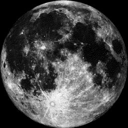
Moon Phase for June 19th at Midnight
0.2 Days Until Full (Strawberry) Moon
0.2 Days Until Full (Strawberry) Moon
June 20, 7:03 a.m. EDT — The Full Strawberry Moon. Known to every Algonquin tribe by that name. Europeans called it the Rose Moon. - Courtesy Space.com HERE:
____________________________________
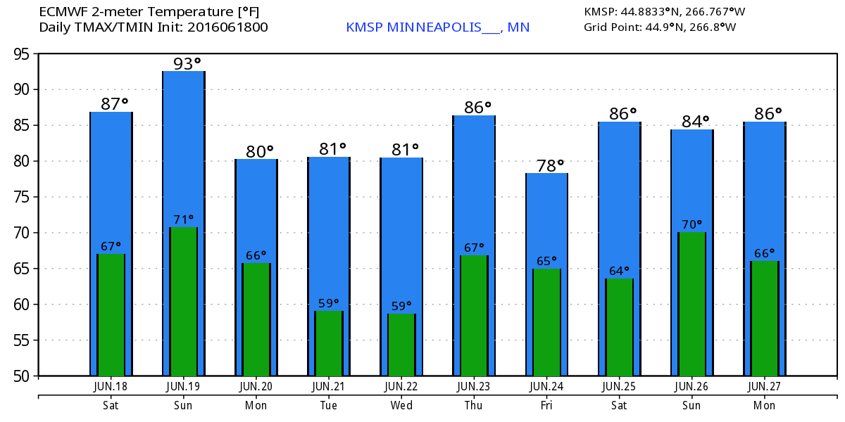
Extended Outlook
A
brief stint of sticky, hot summer weather will be with us through the
weekend, but we cool down back to near normal levels again early next
week. The extended forecast at this point doesn't show any major heat
moving back in through the next 10 days.
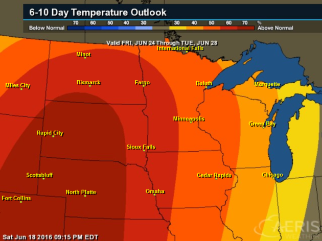
6 to 10 Day Temperature Outlook
According
to NOAA's CPC, the 6 to 10 day temperature outlook suggests above
average temperatures returning to the Midwest from June 24th - 28th. However, the warmest weather looks to stay west of us.
 ______________________________
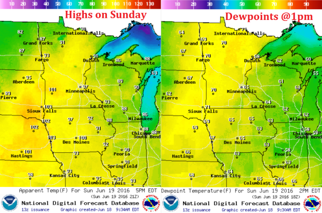
Sunday Weather Outlook
Sunday
will be a VERY warm and humid day with high temperatures across much of
the state in the 90s with a few locations in SW Minnesota nearing 100F!
The other factor will be high dewpoints in the upper 60s to low 70s,
which will bring feels like temps or heat index values to near 100F.
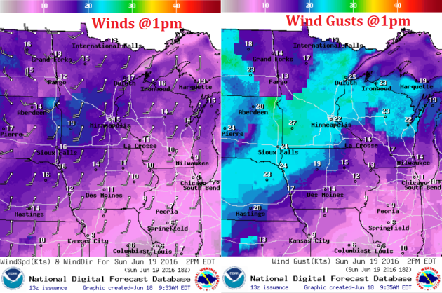
Saturday Weather Outlook
Not
only will Sunday be a hot and sticky day, but it'll also be breezy!
Gusty SSW winds will be up around 10-20mph with gusts approaching 25mph+
at times ahead of a cool front expected to move through the region late
in the day. This front looks to kick up showers and storms in the late
afternoon/evening hours, some of which could be strong to severe.
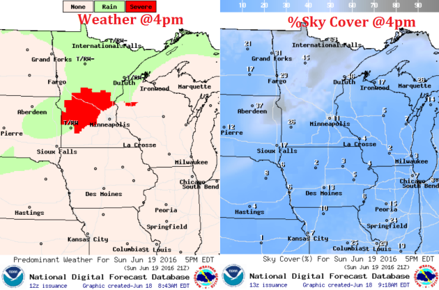
Saturday Weather Outlook
Here's
a look at the weather at 4pm Sunday. Note the red colors showing up in
Central MN, this indicates the potential of strong to severe storms.
Hail and high wind look to be the primary threat along with heavy
pockets of rain... stay tuned and keep an eye/ear on weather forecasts
later in the day.
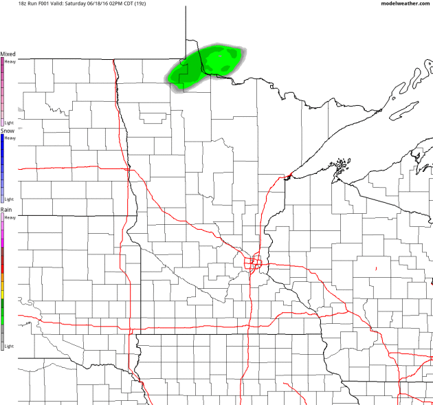
Simulated Radar
The simulated radar through PM
Monday suggests a line of storms popping Sunday across the state on
Sunday afternoon/evening. Keep in mind that some of these storms could
be strong to severe.
Rainfall Potential
Rainfall potential through AM Tuesday suggests heavier rainfall across parts of central and northern MN.
This heavier rainfall potential will be associated with scattered
showers and storms that will be develop late Sunday afternoon/evening.

___________________________________
National Weather Outlook
A
storm system moving into the Western U.S. that brought snow to parts of
the northern Sierra Nevada range will wash out a bit through early
weekend. As this happens, dangerous heat begins develop in the Southwest
through early next week. Meanwhile, scattered showers and storms will
be possible across parts of the Midwest through the early weekend.
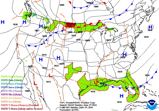
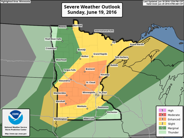
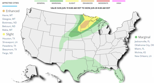
Severe Threat Sunday
...SUMMARY...
   SCATTERED SEVERE STORMS ARE POSSIBLE SUNDAY FROM EASTERN SOUTH
   DAKOTA ACROSS MUCH OF MINNESOTA AND INTO NORTHWEST WISCONSIN WITH
   HAIL AND WIND EXPECTED.

   ...SYNOPSIS...
   BROAD/FLAT RIDGING ALOFT SHOULD PREVAIL ACROSS MOST OF THE U.S. DAY
   2/SUNDAY...WITH LOWS/TROUGHS LINGERING OFF BOTH THE W AND E COASTS
   AND FAST/WLY FLOW AT MID AND UPPER LEVELS CONFINED TO THE NRN U.S.
   AND ADJACENT SRN CANADA.  A FAST-MOVING SHORT-WAVE TROUGH -- WITHIN
   THE AFOREMENTIONED WLY FLOW FIELD -- IS PROGGED TO SKIRT THE
   U.S./CANADA BORDER REGION...MOVING QUICKLY EWD FROM MT EARLY IN THE
   PERIOD TO THE UPPER GREAT LAKES  REGION/WRN ONTARIO LATE.

   AT THE SURFACE...A COLD FRONT INITIALLY PROGGED TO EXTEND FROM A LOW
   INVOF NERN ND/NWRN MN/SERN MANITOBA SWWD ACROSS THE DAKOTAS AND INTO
   THE INTERIOR WRN U.S. IS FORECAST TO MAKE STEADY EWD PROGRESS ACROSS
   THE N CENTRAL CONUS.  BY THE END OF THE PERIOD...THE FRONT SHOULD
   EXTEND FROM THE WRN UPPER GREAT LAKES REGION SWWD ACROSS THE UPPER
   MIDWEST/MID MO VALLEY AND THEN WWD INTO THE CENTRAL HIGH PLAINS.
   THIS FRONT WILL FOCUS THE PRIMARY ZONE OF SEVERE RISK THIS PERIOD.

   ...WRN UPPER GREAT LAKES/UPPER MS VALLEY REGION SWWD TO ERN SD/NWRN
   IA...
   AN OVERNIGHT/ONGOING MCS INVOF THE INTERNATIONAL BORDER -- I.E.
   PARTS OF ERN ND AND NWRN MN -- MAY BE ONGOING AT THE START OF THE
   PERIOD...WHICH COULD POSE LINGERING SEVERE RISK /HAIL AND/OR
   DAMAGING WINDS/ ACROSS PARTS OF THIS AREA.  EXPECT THIS ACTIVITY TO
   DIMINISH WITH SWD EXTENT THROUGH THE MORNING...PRIMARILY AFFECTING
   SWRN ONTARIO.  MEANWHILE...NEW/AFTERNOON THUNDERSTORM DEVELOPMENT IS
   FORECAST TO OCCUR ACROSS MN/ERN SD INVOF THE ESEWD-MOVING COLD
   FRONT...AS STEEP LAPSE RATES ALOFT COMBINE WITH A MOIST/HEATING
   BOUNDARY LAYER TO YIELD MODERATE TO STRONG INSTABILITY /3000 TO 4000
   J/KG MIXED-LAYER CAPE/.  CAPPING SHOULD HINDER DEVELOPMENT UNTIL MID
   AFTERNOON ACROSS THIS AREA...AND SHOULD MORE SUBSTANTIALLY LIMIT
   PROSPECTS FOR ANY MORE THAN ISOLATED STORMS WITH SWWD EXTENT ALONG
   THE FRONT INTO THE NEB VICINITY.

   AS THE UPPER TROUGH TRAVERSING THE INTERNATIONAL BORDER
   ADVANCES...STRONG MID-LEVEL FLOW /50 TO 60 KT/ SHOULD OVERSPREAD
   CENTRAL AND NRN MN DURING THE AFTERNOON.  ATOP BOUNDARY-LAYER SSWLY
   WINDS IN THE WARM SECTOR...SHEAR WILL BECOME VERY SUPPORTIVE OF
   SUPERCELLS -- AND THUS A FEW INTENSE CELLS CAPABLE OF PRODUCING VERY
   LARGE HAIL AND LOCALLY DAMAGING WINDS ARE EXPECTED TO EVOLVE BY LATE
   AFTERNOON/EARLY EVENING.  WITH THE LOSS OF DIURNAL
   HEATING/BOUNDARY-LAYER STABILIZATION AS THE EVENING WEARS
   ON...SEVERE RISK SHOULD GRADUALLY DIMINISH AS STORMS SPREAD EWD INTO
   THE UPPER GREAT LAKES REGION.
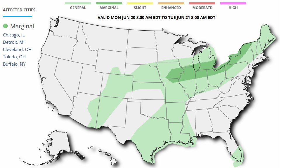
Severe Threat Monday
...SUMMARY...
   ISOLATED MARGINALLY SEVERE THUNDERSTORMS CAPABLE OF WIND AND HAIL
   ARE POSSIBLE ON MONDAY FROM EASTERN IOWA ACROSS THE LOWER GREAT
   LAKES REGION.

   ...SYNOPSIS...
   A LARGE AREA OF LOW PRESSURE WILL DEEPEN OVER WRN QUEBEC DURING THE
   DAY WITH A COLD FRONT DRAPED W-E FROM THE UPPER MS VALLEY EWD ACROSS
   THE LOWER GREAT LAKES AREA. AHEAD OF THIS FRONT...A WARM AND MOIST
   AIR MASS WILL EXIST...RESULTING IN MODEST LEVELS OF INSTABILITY.
   ALOFT...AN INTENSE SHORTWAVE TROUGH AND CYCLONICALLY-CURVED MIDLEVEL
   JET WILL DIVE SEWD ACROSS THE UPPER MS VALLEY AND INTO THE GREAT
   LAKES...WITH MOST OF THE STRONGER FLOW BEHIND THE SFC FRONT.

   ...ERN IA...NRN IL/IN/OH...SRN LOWER MI...NWRN PA AND WRN AND NRN
   NY...
   SPORADIC SHOWERS AND STORMS ARE EXPECTED TO BE ONGOING IN
   ASSOCIATION WITH THE COLD FRONT MONDAY MORNING FROM NEBRASKA EWD
   ACROSS IA...WI AND MI...WITH PERHAPS SOME MARGINALLY SEVERE WIND
   GUSTS WITH ANY ONGOING LINES OF STORMS. LATER IN THE DAY...STRONG
   HEATING WILL OCCUR AHEAD OF THE COLD FRONT AND AID IN REDEVELOPMENT.
   SINCE THE AREA IS S OF THE UPPER JET...THERE MAY BE SOME SUBSIDENCE
   ALOFT AS INDICATED IN FORECAST SOUNDINGS WITH WARM LAYERS IN THE
   MIDLEVELS. IN ADDITION...SHEAR WILL NOT BE PARTICULARLY STRONG...BUT
   MAY SUPPORT MARGINALLY SEVERE STORMS ESPECIALLY ACROSS THE LAKE
   ERIE/ONTARIO AREA CLOSER TO THE STRONGER FLOW ALOFT.
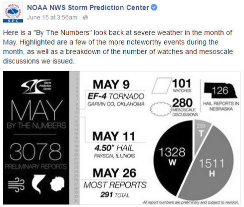
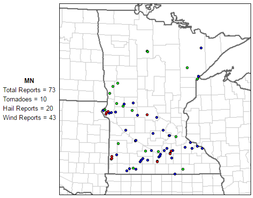
May Severe Weather
May,
on average, sees the most tornadoes out of any other month across the
nation, averaging 276. Here's a look at the severe weather numbers
across the nation for May 2016, which saw 239 tornado reports.
Average Tornadoes in June
While
May, on average, sees the most tornadoes across the nation, June is
typically the most active tornado month is Minnesota, averaging 18.
Interestingly, The yearly average tornado count is 45.
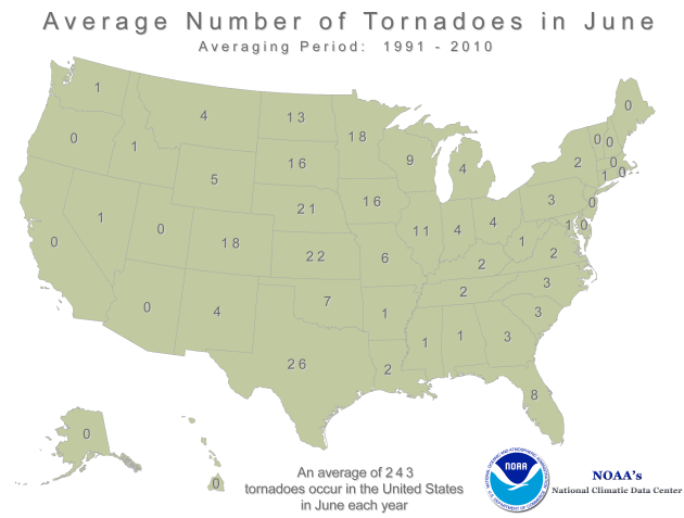
June Tornadoes in Minnesota
According
to NOAA's SPC, there have been 10 tornadoes in Minnesota so far this
month, most of which happened on Tuesday, June 14th.
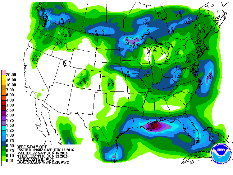
5 Day Rainfall Potential
According
to NOAA'S WPC, the 5 day rainfall forecast suggests heavier pockets of
rain across parts of the northern tier of the nation through the
Mid-Atlantic states and into the Southeastern U.S.. Keep in mind that
with thunderstorm activity, some locations could see 1" to 2"+ through
the end of the weekend.
 __________________________________
"Growing Up With Climate Change"
"y generation will be the first to have lived an entire lifetime in a climate changed world. We witnessed the first climate impacts. We will experience the worst. We were born into this crisis and did nothing to cause it. Everything that we know and love—from our backyards to the existence of Planet Earth—is threatened. This is a generation unlike any other.What is it like to grow up with this new climate reality? I spoke to six young people who have been working on climate change from a young age and know what it’s like to grow up with this crisis. Their ages range from 13 to 29. Each confronts a different face of the crisis, from the coal mines of West Virginia to the drought-stricken plains of Kenya. Their words offer a glimpse into the challenges, heartaches, opportunities, and hope of growing up with climate change. There is one key theme that unites these young people: the commitment to self-determination. Each has crisis thrust upon them. They know that climate change will inevitably impact their futures, homes, families, communities. There is a sense of doom, of unavoidable catastrophe. They could be passive victims, absorbing the consequences of a warmed world. They could allow climate change to dictate their destiny."
Read more from TheNation.com HERE:
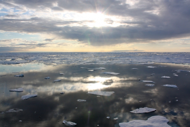
 ___________________________________________________"Scientists Urge Obama to Halt Oil Leasing in the Arctic"
In a letter being delivered to the White House on Thursday, nearly 400 scientists from more than a dozen countries are urging President Obama to stop future oil and gas drilling in the Arctic Ocean because of the significant environmental and climate risks associated with further fossil fuels exploration there. “No new oil and gas leasing or exploration should be allowed in the Chukchi and Beaufort seas in the foreseeable future,” the scientists said. Climate change is warming the Arctic twice as fast as the rest of the world, melting sea ice to historically low levels and threatening the viability of the region’s vibrant ecosystems. The scientists contend that environmentally sensitive areas of the Beaufort and Chukchi seas off of Alaska’s North Slope should be off-limits to oil and gas drilling while protecting the long-term health of the Arctic Ocean. “The Arctic is home to vibrant communities of indigenous peoples, provides vital marine habitats for iconic wildlife such as beluga whales, walruses, and ice seals found nowhere else in the United States, and plays a critical role in global climate systems,” the letter said. “The region is profoundly affected by climate change — including loss of sea ice, acidification of the ocean, and increased access for industries that pose significant risks to the ocean environment.”
Read more from Climate Central HERE:
(Sea ice in the Chukchi Sea off the North Slope of Alaska. Credit: NASA Goddard Space Flight Center/flickr)
 ________________________________________"IBM's Deep Thunder Shows How Weather is Big Business "
"IBM Research and The Weather Company are putting forecasting models and machine learning to work on historical data. The result? Deep Thunder, a hyper-local forecasting tool offering precision insights and predictions for business customers. The Weather Company, which is now a part of IBM, has a new commercial offering called Deep Thunder, announced this week. Deep Thunder combines hyperlocal, short-term custom forecasts developed by IBM Research with The Weather Company's existing global forecast model. Deep Thunder will use historical weather data to train machine learning models to help businesses predict the actual impact of weather, IBM said in a statement released June 15. The name Deep Thunder had already been in use by a team within IBM. This new commercial offering, however, marks the first time IBM has used Deep Thunder as a brand name, and the first time The Weather Company's capabilities have been combined into the project."
See more from Informationweek.com HERE:
(Image courtesy: Informationweek.com via DKart/iStockphoto)

"y generation will be the first to have lived an entire lifetime in a climate changed world. We witnessed the first climate impacts. We will experience the worst. We were born into this crisis and did nothing to cause it. Everything that we know and love—from our backyards to the existence of Planet Earth—is threatened. This is a generation unlike any other.What is it like to grow up with this new climate reality? I spoke to six young people who have been working on climate change from a young age and know what it’s like to grow up with this crisis. Their ages range from 13 to 29. Each confronts a different face of the crisis, from the coal mines of West Virginia to the drought-stricken plains of Kenya. Their words offer a glimpse into the challenges, heartaches, opportunities, and hope of growing up with climate change. There is one key theme that unites these young people: the commitment to self-determination. Each has crisis thrust upon them. They know that climate change will inevitably impact their futures, homes, families, communities. There is a sense of doom, of unavoidable catastrophe. They could be passive victims, absorbing the consequences of a warmed world. They could allow climate change to dictate their destiny."
Read more from TheNation.com HERE:
In a letter being delivered to the White House on Thursday, nearly 400 scientists from more than a dozen countries are urging President Obama to stop future oil and gas drilling in the Arctic Ocean because of the significant environmental and climate risks associated with further fossil fuels exploration there. “No new oil and gas leasing or exploration should be allowed in the Chukchi and Beaufort seas in the foreseeable future,” the scientists said. Climate change is warming the Arctic twice as fast as the rest of the world, melting sea ice to historically low levels and threatening the viability of the region’s vibrant ecosystems. The scientists contend that environmentally sensitive areas of the Beaufort and Chukchi seas off of Alaska’s North Slope should be off-limits to oil and gas drilling while protecting the long-term health of the Arctic Ocean. “The Arctic is home to vibrant communities of indigenous peoples, provides vital marine habitats for iconic wildlife such as beluga whales, walruses, and ice seals found nowhere else in the United States, and plays a critical role in global climate systems,” the letter said. “The region is profoundly affected by climate change — including loss of sea ice, acidification of the ocean, and increased access for industries that pose significant risks to the ocean environment.”
Read more from Climate Central HERE:
(Sea ice in the Chukchi Sea off the North Slope of Alaska. Credit: NASA Goddard Space Flight Center/flickr)
"IBM Research and The Weather Company are putting forecasting models and machine learning to work on historical data. The result? Deep Thunder, a hyper-local forecasting tool offering precision insights and predictions for business customers. The Weather Company, which is now a part of IBM, has a new commercial offering called Deep Thunder, announced this week. Deep Thunder combines hyperlocal, short-term custom forecasts developed by IBM Research with The Weather Company's existing global forecast model. Deep Thunder will use historical weather data to train machine learning models to help businesses predict the actual impact of weather, IBM said in a statement released June 15. The name Deep Thunder had already been in use by a team within IBM. This new commercial offering, however, marks the first time IBM has used Deep Thunder as a brand name, and the first time The Weather Company's capabilities have been combined into the project."
See more from Informationweek.com HERE:
(Image courtesy: Informationweek.com via DKart/iStockphoto)
_________________________________________
Thanks for checking in and don't forget to follow me on Twitter @TNelsonWX

No comments:
Post a Comment