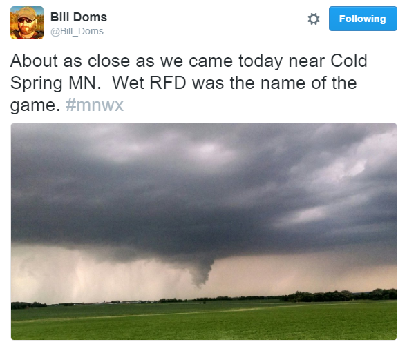
Severe Storms Sunday
Thanks to @Bil_Doms for this picture from near Cold Spring in Stearns county from PM Sunday.
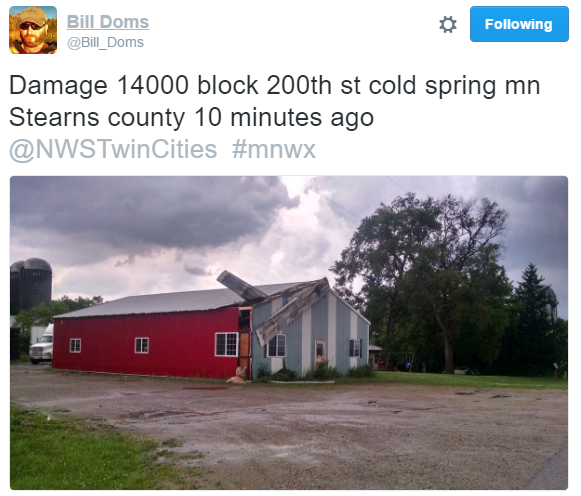
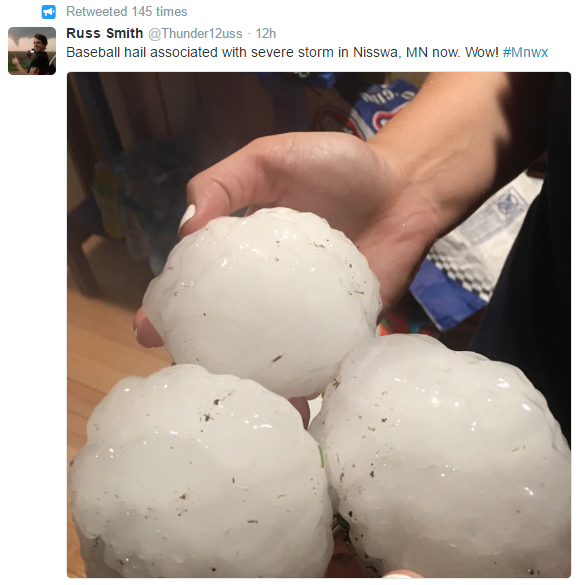
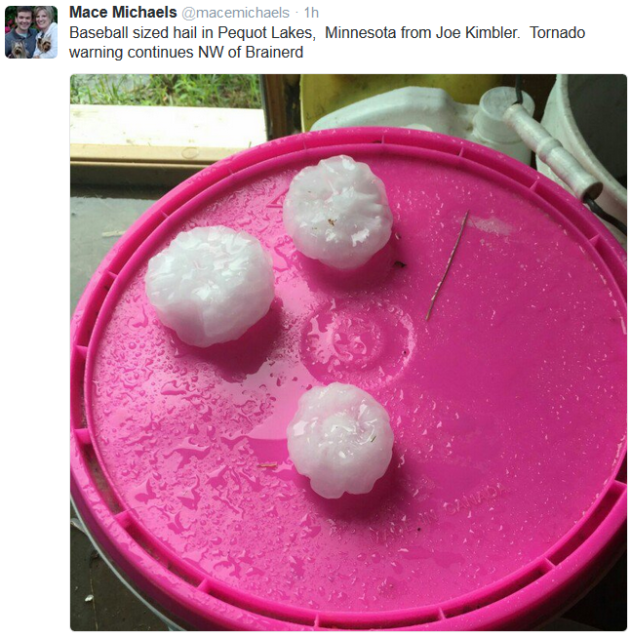
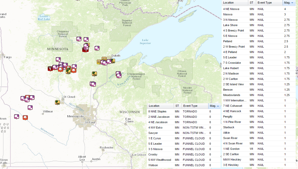
Large Hail Reports
Several Storm Reports Sunday
There were a number of large hail reports (up to grapefruit size (4") near Nisswa) and even tornado reports. The National Weather Service out of Duluth will be conducting damage surveys today to determine strength and path lengths of any tornadoes that may have developed yesterday.
Public Information Statement
National Weather Service Duluth MN
421 AM CDT MON JUN 20 2016

...Damage surveys will be conducted Monday across Northeast
Minnesota...

The National Weather Service in Duluth MN will be conducting damage
surveys on Monday to ascertain the extent of damage caused by severe
thunderstorms on Sunday evening.

We plan to survey three separate corridors:

1) From southern Cass County...eastward across Crow Wing county into
Aitkin County.

2) Along and north of state highway 200 from Hill City... to between
Swan River and Jacobson... to near Meadowlands.

3) From near Pengilly and Silica... eastward to Zim and Whiteface
Reservoir.

We will do our best to provide more detailed information on the
locations and magnitude of damage...and preliminary EF scale ratings
for tornadoes by the evening news.  However...the areas to survey
are rather expansive...and preliminary reports indicate that in some
areas...sorting out tornado versus non-tornadic wind damage could be
somewhat complicated...and we greatly appreciate patience from our
Media and Emergency Management partners during this process.

$$

MILLER/G2
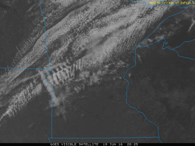
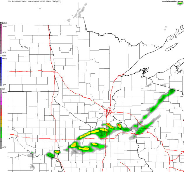
Stormy Sunday Night
Take a look at the storms that exploded PM Sunday across central and northeast MN. These storms were responsible for extremely large hail and even tornadoes.
.gif)
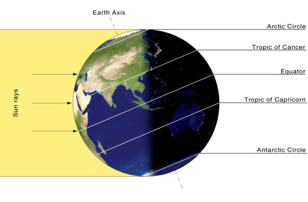
Summer Begins 5:34pm CDT
At 5:34pm CDT, the suns most direct rays will be shining over the Tropic of Cancer at 23.5° latitude N. Summer will then begin for folks in the northern hemisphere, while winter begins for folks in the southern hemisphere. It will be officially summer for 3 months until the 22nd of September.
____________________________________________
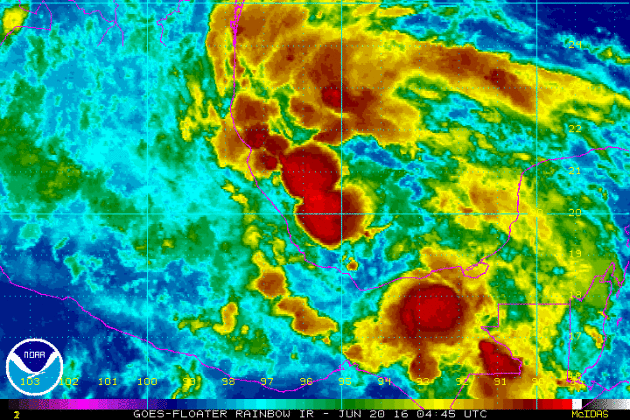
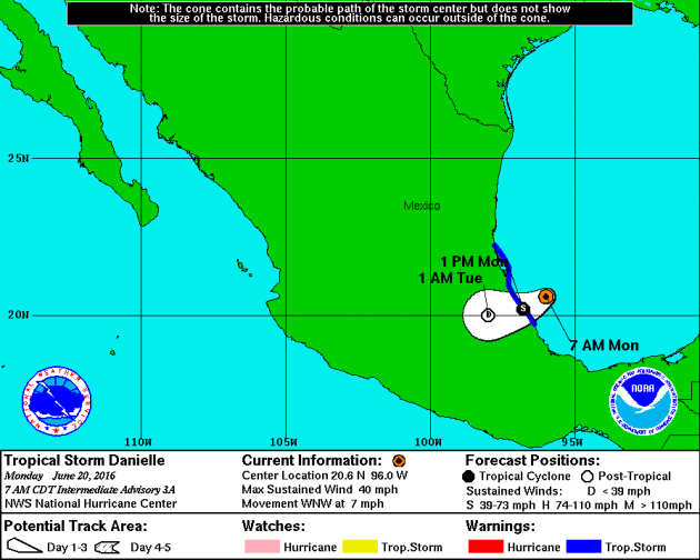
Tropical Storm DANIELLE
The National Hurricane Center started issuing statements on Tropical Depression FOUR in the Bay of Campeche Sunday afternoon and by AM Monday, it was upgraded to a tropical storm. DANIELLE is expected to continue pushing west into mainland Mexico before diminishing rather rapidly over land on Tuesday.
Tracking DANIELLE
Here's the official forecast track for DANIELLE, which shows the system making landfall in central Mexico around midday Monday and then falling to tropical depression status by early Tuesday morning.
____________________________________
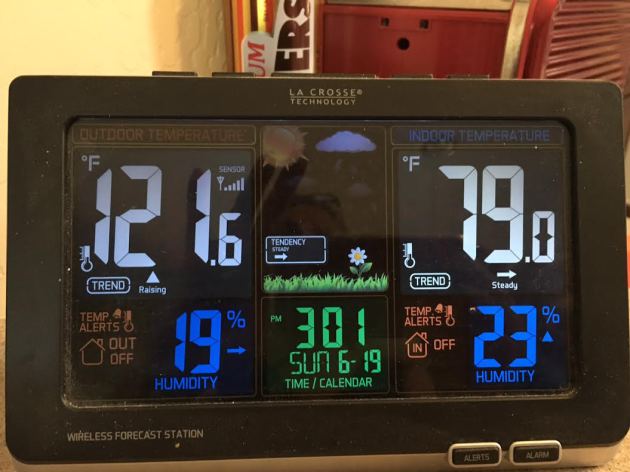
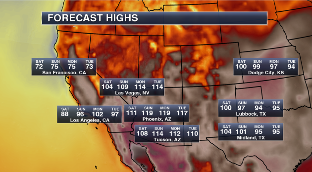
HOT HOT HOT!
Thanks to my mom for sending me this picture from Phoenix, AZ, where their outdoor thermometer on Sunday was already reading 121F by midday! Good grief! Sunday was expected to be the hottest day of the heat wave topping out near 120F with a slight cooldown on Monday to 115F - that heat is no joke!
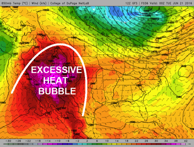
Excessive Heat Continues in the Southwest
This impressive dome of hot weather will continue into early this week with high temperatures in many locations will warm into the triple digits! Some may even be in record territory through the early week time frame.
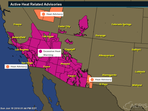
Excessive Heat Watches and Warnings
The National Weather Service has issued a number of excessive heat headlines across the Southwest, which includes major cities like San Diego, Los Angeles, Las Vegas, Phoenix, Tucson and Yuma.
...EXCESSIVE HEAT WARNING REMAINS IN EFFECT THROUGH 9 PM MST /9 PM PDT/ WEDNESDAY...
* AFFECTED AREA...THE SOUTHEAST CALIFORNIA...SOUTHWEST AND SOUTH CENTRAL ARIZONA DESERTS AND MOUNTAIN VALLEYS INCLUDING THE GREATER PHOENIX AREA... THE IMPERIAL VALLEY OF CALIFORNIA...THE COLORADO RIVER...GLOBE MIAMI...THE SALT RIVER RECREATIONAL LAKES...AND ROOSEVELT LAKE.
* TEMPERATURE...HIGHS THROUGH MONDAY IN THE LOWER DESERTS FROM 115 TO 120 DEGREES. HIGHS TUESDAY AND WEDNESDAY FROM 112 TO 115. IN THE HIGHER TERRAIN OF SOUTHERN GILA COUNTY...HIGH TEMPERATURES WILL TOP OUT AROUND 110 DEGREES SUNDAY AND MONDAY.
* IMPACTS...HEAT RELATED ILLNESS WILL BE LIKELY FOR THOSE DOING STRENUOUS ACTIVITY OUTDOORS...OR THOSE WITH HEALTH CONDITIONS THAT DO NOT HAVE ADEQUATE ACCESS TO AIR CONDITIONING. IF UNTREATED...SOME ILLNESS EVENTS COULD BE FATAL.
Potential High Temperatures & Stats
Phoenix, AZ
- Highs will approach 120 on both Sunday and Monday. Phoenix has only had a high of 120 or higher three times in their recorded history (since 1895).
- The last time Phoenix hit 120 or higher was back on July 28, 1995 when the thermometer hit 121.
- Whether the temperature touches 120 or not, record highs are likely. The current record high each day between Saturday and Tuesday is 115.
- The last time Phoenix hit 120 or higher was back on July 28, 1995 when the thermometer hit 121.
- Whether the temperature touches 120 or not, record highs are likely. The current record high each day between Saturday and Tuesday is 115.
Tucson, AZ
- We are calling for a forecast high of 114 on Sunday. Only seven times in Tucson recorded history (since 1894) has the city seen a high of 114 or higher – the last time occurring on July 28, 1995 when it also reached 114.
- The all-time record in Tucson history is 117 set back on June 26, 1990.
- Record highs over the weekend and into next week are 113 Saturday, 112 Sunday, 110 Monday and 112 Tuesday.
- The all-time record in Tucson history is 117 set back on June 26, 1990.
- Record highs over the weekend and into next week are 113 Saturday, 112 Sunday, 110 Monday and 112 Tuesday.
Las Vegas, NV
- Las Vegas is no stranger this type of higher heat in the forecast, reaching a temperature of 115 or higher 55 times since 1937. The last time Las Vegas saw a high of 115 or higher was back on July 2, 2013.
- The warmest high ever in Las Vegas history is 117 reached three times in their history. The most recent occurrence was back on June 30, 2013.
- Our forecast has Las Vegas reaching 114 both Monday and Tuesday next week.
- Record highs this weekend into next week are 115 Saturday, 114 Sunday, 113 Monday and 111 Tuesday.
Los Angeles, CA
- Even Los Angeles will get in on the heat this week into early next week, reaching at least the mid 90s Sunday through Tuesday.
- We could even see highs in downtown Los Angeles break the triple-digit mark next Monday. Down toward LAX, highs Monday will be near 90, which could break the record for the day of 86.
- We could even see highs in downtown Los Angeles break the triple-digit mark next Monday. Down toward LAX, highs Monday will be near 90, which could break the record for the day of 86.
(Image and stats courtesy: DJ Kayser @DKayserWX)
When will the heat end?
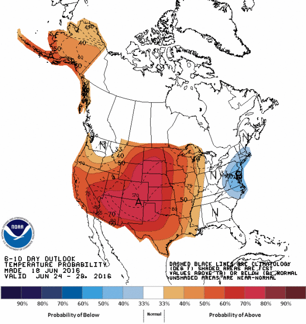
According to NOAA's CPC, the 6 to 10 day temperature outlook still suggest warmer than average weather continuing into next week with some of the heat spilling back out into the Plains. It appears that the 2nd half of June will remain VERY summer-like for many locations in the western half of the country.
Heavy Rainfall Last Week
Here's a look at rainfall from AM June 13th to AM June 18th. Note that there were several locations that saw 1" to 2"+ amounts with some spots even seeing 3" to 4"+. Here's an excerpt from Mark Seeley's Weather Talk on the heavy rains last week.
The warm and humid conditions of last weekend help set the stage for numerous thunderstorms this week across much of the state. Recall that the weather of last weekend produced widespread readings in the 90s F around the state, including a record high of 98°F at Winnebago on the 11th, and a record high of 96°F at Lake Wilson on the same date. Many observers also reported near record dew points in the 70s F, leading to Heat Index readings over 100°F in many places. This represents a large quantity of water vapor which does not allow the air to cool off much at night. As a result, Tracy set a new record warm minimum temperature on the 10th, with a reading of 73°F.
All of the water vapor in the atmosphere served as fuel for thunderstorms, which became widespread across the state over June 11-14. Over those 4 days many areas received from 2-4 inches of rain. A few highly localized amounts were even greater causing some short-lived flooding concerns. You can read more about the distribution of these storms at the Minnesota StateClimatology Office web site.
All of the water vapor in the atmosphere served as fuel for thunderstorms, which became widespread across the state over June 11-14. Over those 4 days many areas received from 2-4 inches of rain. A few highly localized amounts were even greater causing some short-lived flooding concerns. You can read more about the distribution of these storms at the Minnesota StateClimatology Office web site.
Some climate stations reported new daily rainfall records as a result of these thunderstorms. These included: on the 11th Lake City 2.03 inches; on the 12th Thorhult 1.70 inches; on the 13th Eveleth 2.51", Dassel 3.19", Embarrass 1.96", and Stillwater 1.54"; on the 14th Amboy 2.00"; and on June 15th record values were reported for La Crescent 1.78", Melrose 1.80", Caledonia 1.51", Harmony 2.07", Houston 2.83", Waseca 3.19", and Forest Lake 2.00".
The strong thunderstorms on June 14th produced tornadoes in Pipestone, Traverse, Big Stone, Le Sueur, and Blue Earth Counties. All were relatively short-lived and produced relatively little damage. Very strong winds up to 60mph were also reported from portions of Nobles, Jackson, Cottonwood, Brown, and Watonwan Counties.
As a result of the rainy week, many climate stations are already reporting total monthly rainfall that exceeds the June normal. This continues a recent climate trend for June, as 15 of the most recent Junes have been normal or wetter than normal on a statewide basis.
As a result of the rainy week, many climate stations are already reporting total monthly rainfall that exceeds the June normal. This continues a recent climate trend for June, as 15 of the most recent Junes have been normal or wetter than normal on a statewide basis.

Summer begins! Not quite as hot or humid.
By Todd Nelson, filling in for Douglas
By Todd Nelson, filling in for Douglas
WOW, what a weekend! Although it was a bit hot and sticky, this is the type of weather that I tend to long for in the deep of winter. Keep in mind that just 4 short months ago, we were dealing with sub-zero overnight lows. We earn our summers in Minnesota, enjoy it!
Today at 5:34pm CDT, the suns most direct rays will shine over the Tropic of Cancer at 23.5 degrees latitude N, which means that is when summer begins for the northern hemisphere. The summer solstice coincides with the longest days of the year and here in Minneapolis, we'll peak at around 15 hours and 37 minutes of daylight! That's up nearly 6 hours and 51 minutes from the winter solstice on December 22. Interestingly, daylight hours start dwindling after today, but it won't be too noticeable until maybe late mid/late July.
Weather this week features cooler, less muggy conditions with a few spotty showers possible during the second half of the week. All in all, not too bad for mid June. Higher humidity returns this weekend, but hey, it's summer!
___________________________
___________________________
Extended Forecast
MONDAY: Summer begins at 5:34pm CDT. Sunny with a refreshing breeze. Winds: NW 10-20. High: 80
MONDAY NIGHT: Mostly clear and a little breeze. Winds: NW 10-15. Low: 60.
TUESDAY: Beautiful! Low humidity and bright sun. Spotty thunder chance develops overnight. Winds: WNW 5-10. High: 81
WEDNESDAY: More humid. Afternoon thunder risk. Winds: E 5-15. Wake-up: 62. High: 79
THURSDAY: Lingering AM shower, sunnier by PM. Winds: NNE 5-10. Wake-up: 62. High: 78.
FRIDAY: Warmer, few clouds. Winds: SW 5-10. Wake-up: 63. High: 82
SATURDAY: Getting sticky again. PM storm threat. Winds:SSW 10-15. Wake-up: 64. High: 86.
SUNDAY: Unsettled. Late day T-showers. Winds: SW 10-15. Wake-up: 69. High: 86.
______________________________
______________________________
This Day in Weather History
June 20th
June 20th
1992: Abnormally cold conditions occur across the north. Temperatures drop to 26 at Embarrass, MN and Hayward, WI, but the cold spot is 24 at Brimson, MN.
_______________________________
_______________________________
Average High/Low for Minneapolis
June 20th
June 20th
Average High: 80F (Record: 98F set in 1933)
Average Low: 61F (Record: 41F set in 1992)
________________________________
Average Low: 61F (Record: 41F set in 1992)
________________________________
Sunrise/Sunset Times for Minneapolis
June 20th
June 20th
Sunrise: 5:27am
Sunset: 9:03pm
Sunset: 9:03pm
*Daylight gained since yesterday: ~3seconds
*Daylight gained since Winter Solstice (December 22nd): ~6hours and 51mins
__________________________________
*Daylight gained since Winter Solstice (December 22nd): ~6hours and 51mins
__________________________________
Moon Phase for June 20th at Midnight
0.8 Days After Full (Strawberry) Moon
0.8 Days After Full (Strawberry) Moon
June 20, 6:03 a.m. CDT — The Full Strawberry Moon. Known to every Algonquin tribe by that name. Europeans called it the Rose Moon. - Courtesy Space.com HERE:
____________________________________
Extended Outlook
Here's the extended outlook through the end of June and note that doesn't appear to be too much in the way of extensive heat through that time period. We may have a few instances of warm days and higher humidity values, but it doesn't look to bad.
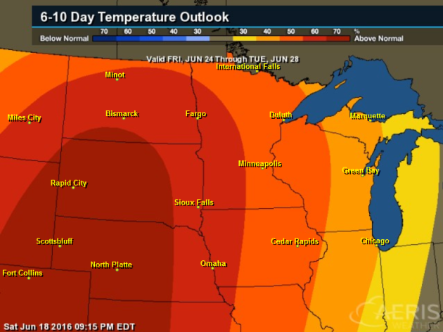
6 to 10 Day Temperature Outlook
According to NOAA's CPC, the 6 to 10 day temperature outlook suggests a fairly good chance of above average temperatures from June 24th to the 28th.
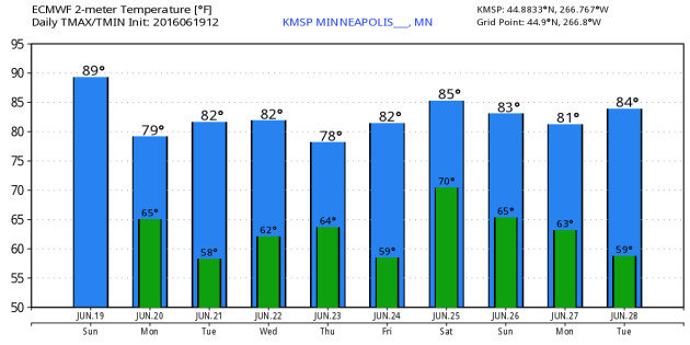
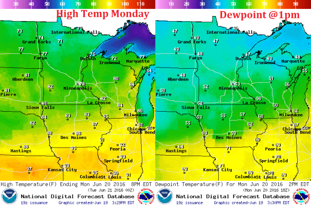
Monday Weather Outlook
After a hot and sticky Sunday, temperatures on Monday look quite a bit cooler with much lower humidity values. Dewpoints look to drop into the 40s and 50s across much of the state, which is nearly 20 degrees lower in some locations than they were on Saturday and Sunday. Keep in mind that for every 20 degree dewpoint drop, there is half as much water in the air than as before.
Monday Weather Outlook
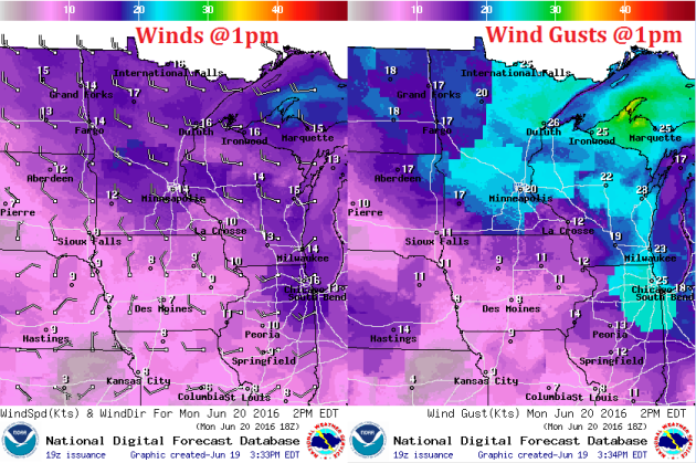
Winds on Sunday were quite breezy out of the SSW helping to usher in lots of heat and humidity. We will be behind the cool front on Monday, so a WNW wind will blow at 15-25mph across the state, but it will be a much cooler and drier wind! It will feel quite a bit nicer than it did this weekend.
Monday Weather Outlook
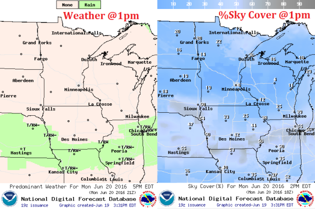
The front will quickly dive south on Monday, which will push spotty shower and storm chances well south of the region. This will also help to bring cooler and drier air to the region, which will help to produce more sunshine as we head into the early part of the week.
Simulated Radar
Here's the simulated radar through midday Tuesday, which shows much quieter conditions across the region on Monday post front. However, unsettled weather looks to return as we head into teh PM Tuesday to Wednesday time frame.
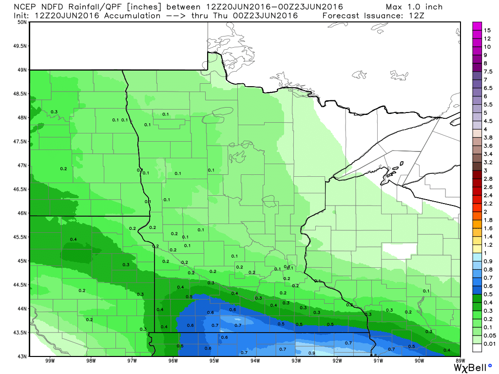
Rainfall Potential
Here's the rainfall potential through 7pm Wednesday, which shows spotty heavy rainfall potential across far southern MN as showers and storms push back into the region late Tuesday into Wednesday.
___________________________________
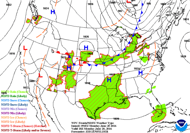
National Weather Outlook
A cold front sweeping through the Upper Midwest PM Sunday into Monday will set up over parts of the Great Lakes/Ohio Valley on Monday and Tuesday with chances of strong to severe storms in those locations. As the next storm system develop and pushes east, better chances of severe weather develop across the Midwest/Great Lakes/Ohio Valley on Wednesday.
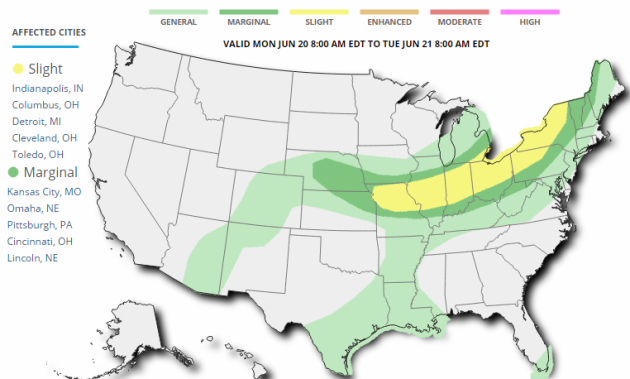
Severe Threat Monday
...SUMMARY...
   ISOLATED TO SCATTERED SEVERE THUNDERSTORMS CAPABLE OF WIND AND HAIL
   ARE POSSIBLE DURING THE AFTERNOON AND EVENING FROM SOUTHEAST LOWER
   MICHIGAN INTO OHIO AND INDIANA AND WESTWARD THROUGH ILLINOIS TO
   NORTHERN MISSOURI AND PERHAPS NORTHEAST KANSAS.  MEANWHILE...THE
   GREATEST POTENTIAL FOR STRONG TO SEVERE STORMS FURTHER EAST ACROSS
   PARTS OF PA TO THE WESTERN AND NORTHERN NEW YORK REGION SHOULD BE
   DURING THIS EVENING.  ISOLATED STRONG TO SEVERE STORMS PRODUCING
   MAINLY HAIL WILL BE POSSIBLE THIS EVENING INTO EARLY TUESDAY MORNING
   ACROSS PARTS OF NEBRASKA TO SOUTHERN IOWA AND NORTHERN MISSOURI.

   ...SYNOPSIS...
   A SHORTWAVE TROUGH ENTERING THE BASE OF A LARGE-SCALE TROUGH
   /CENTERED OVER HUDSON BAY CANADA/ THIS FORECAST PERIOD WILL AMPLIFY
   AS IT MOVES INTO THE GREAT LAKES AND ONTARIO THIS MORNING AND
   AFTERNOON...AND THEN PROGRESS THROUGH SOUTHERN ONTARIO/QUEBEC AND
   NORTHERN NEW ENGLAND THIS EVENING TO EARLY TUESDAY MORNING /21/12Z/.
    A BAND OF STRONG CYCLONIC MID- TO UPPER-LEVEL WINDS WILL ACCOMPANY
   THE SHORTWAVE TROUGH...SPREADING ACROSS MUCH OF THE GREAT LAKES
   REGION THROUGH THIS AFTERNOON.  THIS STRONG WIND FIELD WILL THEN
   SPREAD INTO NORTH PORTIONS OF IL/IN AND THROUGH THE UPPER OH VALLEY
   AND PA INTO NORTHERN NEW ENGLAND THIS EVENING.

   AT THE SURFACE...A COLD FRONT...ATTENDANT TO THE GREAT LAKES UPPER
   TROUGH...WILL ADVANCE TO THE EAST AND SOUTH THROUGH MUCH OF THE
   GREAT LAKES REGION AND SHOULD EXTEND FROM SOUTHERN ONTARIO TO FAR
   NORTHWEST OH AND NORTHERN IND TO NORTHERN MO BY 21/00Z.  THIS FRONT
   WILL PERSIST EAST AND SOUTH THROUGH TONIGHT...REACHING WESTERN NEW
   ENGLAND AND SOUTHERN PORTIONS OF PA/OH/IND/IL BY 12Z TUESDAY.  THE
   WESTERN PORTION OF THIS FRONT IS EXPECTED TO STALL IN VICINITY OF
   THE NEB/KS BORDER INTO NORTHERN MO.
Severe Threat Tuesday
...SUMMARY...
   SCATTERED STRONG TO SEVERE STORMS ARE POSSIBLE FROM THE OHIO VALLEY
   EASTWARD TO THE DELMARVA ON TUESDAY. ISOLATED SEVERE STORMS ARE ALSO
   POSSIBLE TUESDAY NIGHT FROM FAR EASTERN NEBRASKA INTO NORTHWESTERN
   ILLINOIS...AND ACROSS THE NORTHERN HIGH PLAINS. WIND AND HAIL WILL
   BE THE PRIMARY THREATS IN ALL AREAS.

   ...SYNOPSIS...
   AN UPPER LOW WILL BE CENTERED OVER WRN QUEBEC WITH A BROAD AREA OF
   STRONG CYCLONIC FLOW ALOFT SPREADING SWD ACROSS THE NERN QUARTER OF
   THE USA. IN BETWEEN THIS LOW AND THE SWRN U.S. UPPER HIGH WILL BE A
   STRONG JET MAX WHICH WILL NOSE INTO THE UPPER OH VALLEY DURING THE
   DAY WITH COOLING ALOFT INTO THE MID ATLANTIC AS WELL. TO THE W...A
   PROGRESSIVE AND COMPACT SHORTWAVE TROUGH WILL MOVE ACROSS MT LATE IN
   THE DAY...REACHING THE NRN PLAINS WED MORNING.

   AT THE SURFACE...A COLD FRONT WILL SURGE EWD ACROSS NEW
   ENGLAND...WILL STALL SWWD INTO THE OH VALLEY...AND RETURN NWD AS A
   WARM FRONT OVER THE MD MS/MO VALLEYS. WIDESPREAD 60S F DEWPOINTS AND
   DAYTIME HEATING WILL DESTABILIZE A LARGE AREA...WITH SEVERE STORMS
   FOCUSED NEAR THE FRONT.  FARTHER NW INTO MT AND ND...A SFC LOW IS
   FORECAST TO MOVE FROM ERN MT INTO THE DAKOTAS...IN ASSOCIATION WITH
   THE SHORTWAVE TROUGH...AND WILL PROVIDE A FOCUS FOR NIGHTTIME
   STORMS.

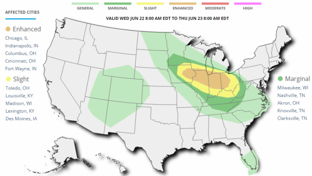
Severe Threat Wednesday
...SUMMARY...
   SEVERE STORMS CAPABLE OF WIDESPREAD DAMAGING WIND...A FEW TORNADOES
   AND LARGE HAIL ARE POSSIBLE ACROSS A LARGE AREA FROM THE UPPER
   MISSISSIPPI VALLEY SOUTHEASTWARD INTO THE OHIO VALLEY DURING THE DAY
   AND OVERNIGHT ON WEDNESDAY.

   ...SYNOPSIS...
   A BROAD BELT OF STRONG NWLY FLOW ALOFT WILL EXIST ACROSS THE NRN
   STATES...WITH MAIN LONG-WAVE TROUGH OVER THE NERN STATES AND UPPER
   HIGH CENTERED OVER THE SRN PLAINS. WITHIN THIS NWLY FLOW REGIME WILL
   BE MULTIPLE DISTURBANCES WHICH ARE LIKELY TO BE ASSOCIATED WITH
   CLUSTERS OF SEVERE STORMS FROM THE UPPER MS VALLEY SEWD TOWARD THE
   OH VALLEY. A SFC LOW WILL MOVE FROM NEBRASKA WED MORNING INTO IA BY
   00Z...WITH A WARM FRONT LIFTING NWD ACROSS THE UPPER MS VALLEY AND
   TOWARD SRN LAKE MICHIGAN. AMPLE MOISTURE AND INSTABILITY WILL BE
   PRESENT TO SUPPORT SEVERE STORMS...WITH STRONG WIND FIELDS POSSIBLY
   SUPPORTING A CORRIDOR OF WIDESPREAD SEVERE STORMS...THE CENTROID OF
   WHICH MAY SHIFT IN LATER OUTLOOKS AS PREDICTABILITY CHANGES.

   ...UPPER MS VALLEY SEWD TOWARD THE OH VALLEY...
   MODELS SHOW A COMPLEX OF STORMS...POSSIBLY SEVERE WITH HAIL AND
   WIND...ONGOING NEAR THE WARM FRONT ROUGHLY FROM IA INTO SRN WI AND
   NRN IL WED MORNING IN ASSOCIATION WITH STRONG WARM ADVECTION.
   COINCIDENT WITH THESE STORMS IS ALSO A SMALL MIDLEVEL SPEED
   MAX/JETLET. AS SUCH...THIS POTENTIAL SYSTEM COULD PERSIST FOR MUCH
   OF THE DAY. BY LATE AFTERNOON...THE AIR MASS WILL BECOME MORE
   UNSTABLE...WITH MUCAPE TO AROUND 3000 J/KG LIKELY...WITH ANOTHER
   SPEED MAX ALOFT POSSIBLY EMBEDDED WITHIN THE NW FLOW. RENEWED
   DEVELOPMENT IS EXPECTED NEAR THE SFC LOW OVER IA DURING THE LATE
   AFTERNOON...WHICH MAY TRACK ALONG ANY OUTFLOW BOUNDARY FROM EARLY
   CONVECTION. THE STRONG FLOW ALOFT AS WELL AS IMPRESSIVE 850 MB
   JET...RESULTING IN VERY STRONG MEAN WIND SPEEDS...ALL POINT TOWARD A
   POSSIBLE WIDESPREAD DAMAGING WIND EVENT IN AND CLOSE TO THE ENHANCED
   RISK AREA. INITIALLY...SUPERCELLS MAY BE PRESENT PRIOR TO STORM
   MERGERS...WITH TORNADOES AND LARGE HAIL.
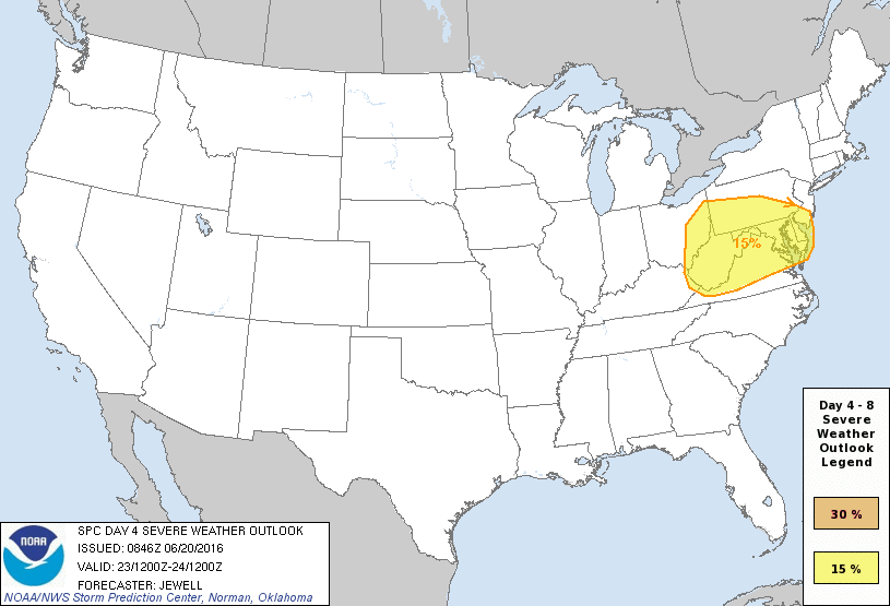
Severe Threat Thursday
...DISCUSSION...
   ON THU/D4...NUMEROUS THUNDERSTORMS...POSSIBLY AN ONGOING MCS...MAY
   EXIST ACROSS OH OR WV THU MORNING...WITH EXACT LOCATION DEPENDING ON
   THE EVOLUTION OF STORMS ON THE PREVIOUS DAY. DESPITE
   UNCERTAINTY...STRONG WLY FLOW WILL BRING A MOIST AND UNSTABLE AIR
   MASS INTO THE REGION AND TO THE ATLANTIC COAST BY MIDDAY. STRONG
   FORCING FOR ASCENT WITH A SFC LOW AND COOLING ALOFT WILL SUPPORT A
   CONTINUATION OF ANY ONGOING ACTIVITY...AND POSSIBLE REDEVELOPMENT
   ESPECIALLY ON SWRN FRINGE WHERE ACCESS TO A MORE PRISTINE AIR MASS
   IS MOST LIKELY. STRONG MEAN WIND FIELDS AND FAVORABLE LIFT WILL BE
   SUPPORTIVE OF DAMAGING WINDS. WILL INTRODUCE A BROAD 15% SLIGHT RISK
   AREA NOW THAT MODELS ARE IN BETTER AGREEMENT WITH THE UPPER
   SHORTWAVE TROUGH AND SFC LOW TRACK.

   ON FRI/D5...ANOTHER STRONG SHORTWAVE TROUGH WILL MOVE INTO THE NRN
   ROCKIES...WITH UPPER RIDGE AXIS SHIFTING EWD TOWARD THE UPPER MS
   VALLEY. MAINLY NOCTURNAL THUNDERSTORMS ARE EXPECTED FRIDAY NIGHT
   ACROSS PARTS OF THE NRN PLAINS AND UPPER MS VALLEY COINCIDENT WITH
   STRONG WARM ADVECTION AND AN APPROACHING COLD FRONT. A BETTER SEVERE
   THREAT MAY EXIST INTO SAT/D6 ACROSS PARTS OF THE MO/UPPER MS VALLEY
   REGION AS THE LOW AND COLD FRONT MATURE...AND A LESSER SEVERE THREAT
   THE NEXT DAY INTO THE OH VALLEY AREA. HOWEVER...PREDICTABILITY IS
   CURRENTLY LOW FOR THIS SYSTEM.
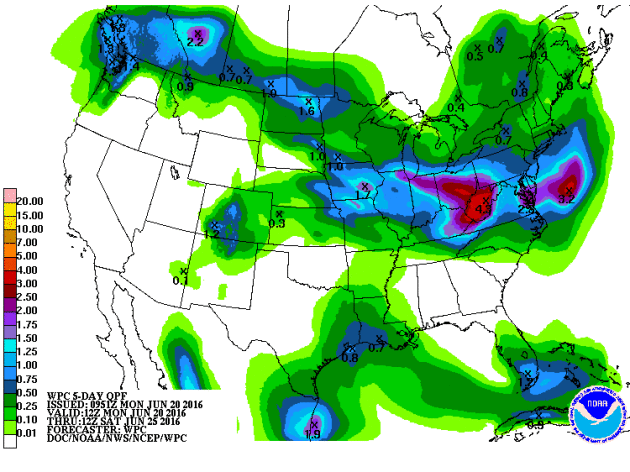
5 Day Rainfall Potential
Here's the 5 day rainfall forecast through the end of the week, which shows heavy rainfall potential from parts of the Midwest to the Ohio Valley with numerous shower and thunderstorm chances through the week ahead.
___________________________________
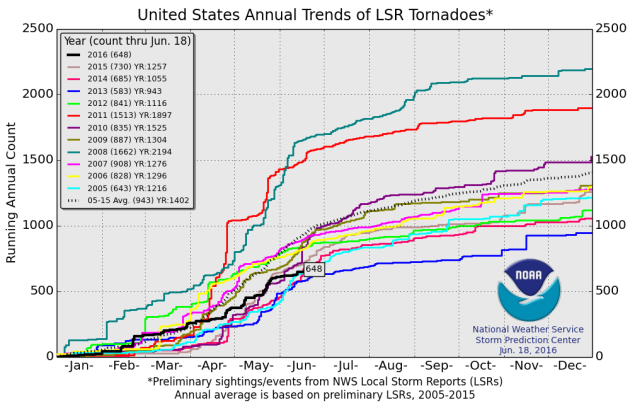
National Tornado Count for 2016
According to NOAA's SPC, the PRELIMINARY tornado count for 2016 (thru June 18th) is 648, which is nearly 300 reports lower than the 2005 to 2015 average.
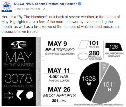
May Severe Weather
May, on average, sees the most tornadoes out of any other month across the nation, averaging 276. Here's a look at the severe weather numbers across the nation for May 2016, which saw 239 tornado reports.
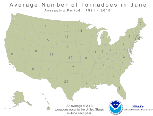
Average Tornadoes in June
While May, on average, sees the most tornadoes across the nation, June is typically the most active tornado month is Minnesota, averaging 18. Interestingly, The yearly average tornado count is 45.
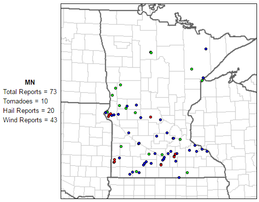
June Tornadoes in Minnesota
According to NOAA's SPC, there have been 10 tornadoes in Minnesota so far this month, most of which happened on Tuesday, June 14th.
__________________________________
"Obama breaks from Yosemite family trip to urge Americans to stop climate change"
"President Obama on Saturday broke from his family vacation in Yosemite National Park to urge Americans to act on climate change, which he argued is destroying the country’s precious natural resources. “Make no mistake, climate change is no longer a threat, it’s a reality,” the president said in a roughly 10-minute speech, ahead of the upcoming 100th anniversary of the National Parks system. Obama said Yosemite rangers told him that signs of climate change, or global warming, are already occurring across the roughly 761,000-acre park in California. “Yosemite’s largest glacier, (once) almost a mile long, is almost gone,” said Obama, standing behind the majestic Yosemite falls. Global warming has in large part been blamed on human activity and on coal and other fossil fuel-burning plants."

________________________________________
"Amid melting Arctic ice, Kerry sees looming climate catastrophe"
"Standing near Greenland's Jakobshavn glacier, the reputed source of the iceberg that sank the Titanic over a century ago, U.S Secretary of State John Kerry saw evidence of another looming catastrophe. Giant icebergs broken off from the glacier seemed to groan as they drifted behind him, signaling eventual rising oceans that scientists warn will submerge islands and populated coastal region. Briefed by researchers aboard a Royal Danish Navy patrol ship, Kerry appeared stunned by how fast the ice sheets are melting. He was struck by the more dire warnings he heard about the same process underway in more remote Antarctica."
Read more from Rueters.com HERE:
U.S. Secretary of State John Kerry waves as he arrives in Greenland with Danish Foreign Minister Kristian Jensen for a tour of the Illulissat Icefjord and Jakobshavn Glacier, June 17, 2016, in Kangerlussuaq, Greenland.
REUTERS/EVAN VUCCI/POOL

__________________________________________"Bringing back the bayou: NASA helps Louisiana wetlands avoid bleak future"
"Louisiana’s coastal wetland habitats are imperiled by several natural and anthropogenic phenomena, including the extreme effects of climate change. They’re home to 40 percent of the nation’s wetlands and account for 80 percent of the annual wetland loss, prompting scientists to project they’ll completely disappear in the next 200 years. “It’s a really big deal right now because Louisiana is losing so much land,” according to Mark Barker, communications fellow for NASA’s DEVELOP Program, part of the agency’s Applied Sciences Program. The program takes a multidisciplinary research approach to bridge the gap between science and society."
Read more from NASA HERE:
Louisiana's Wax Lake Delta in flux
Satellite views of Louisiana's growing Wax Lake Delta from November 7, 1984, to October 25, 2014. Also see this image pair and visit the 'Images of Change' gallery for more views of your changing planet.
__________________________________________
"Standing near Greenland's Jakobshavn glacier, the reputed source of the iceberg that sank the Titanic over a century ago, U.S Secretary of State John Kerry saw evidence of another looming catastrophe. Giant icebergs broken off from the glacier seemed to groan as they drifted behind him, signaling eventual rising oceans that scientists warn will submerge islands and populated coastal region. Briefed by researchers aboard a Royal Danish Navy patrol ship, Kerry appeared stunned by how fast the ice sheets are melting. He was struck by the more dire warnings he heard about the same process underway in more remote Antarctica."
Read more from Rueters.com HERE:
U.S. Secretary of State John Kerry waves as he arrives in Greenland with Danish Foreign Minister Kristian Jensen for a tour of the Illulissat Icefjord and Jakobshavn Glacier, June 17, 2016, in Kangerlussuaq, Greenland.
REUTERS/EVAN VUCCI/POOL
__________________________________________"Bringing back the bayou: NASA helps Louisiana wetlands avoid bleak future"
"Louisiana’s coastal wetland habitats are imperiled by several natural and anthropogenic phenomena, including the extreme effects of climate change. They’re home to 40 percent of the nation’s wetlands and account for 80 percent of the annual wetland loss, prompting scientists to project they’ll completely disappear in the next 200 years. “It’s a really big deal right now because Louisiana is losing so much land,” according to Mark Barker, communications fellow for NASA’s DEVELOP Program, part of the agency’s Applied Sciences Program. The program takes a multidisciplinary research approach to bridge the gap between science and society."
Read more from NASA HERE:
Louisiana's Wax Lake Delta in flux
Satellite views of Louisiana's growing Wax Lake Delta from November 7, 1984, to October 25, 2014. Also see this image pair and visit the 'Images of Change' gallery for more views of your changing planet.
__________________________________________
Thanks for checking in and don't forget to follow me on Twitter @TNelsonWX

No comments:
Post a Comment