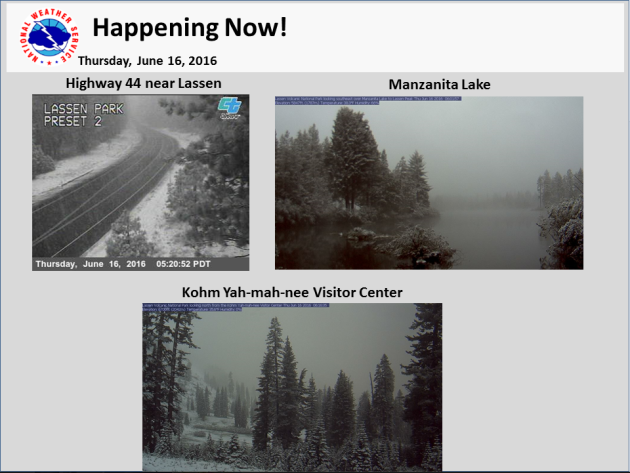
Snow in June?
A
storm system moving into the Western U.S. brought cold enough
temperatures to in the high elevations of the northern Sierra Nevada
range for some minor snow accumulations. Take a look at some of the
webcams that the National Weather Service of of Sacramento, CA posted
early Thursday.
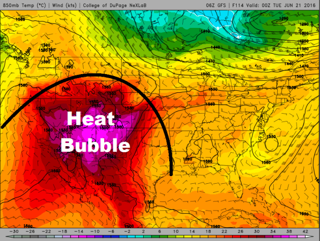
Excessive Heat Building in the Southwest
While
snow was falling in the high elevations of the Sierra Nevada Range on
Thursday morning, dangerous heat is getting ready to build across the
Desert Southwest by the weekend and into early next week. The image
below show the heat bubble near its peak on Monday.
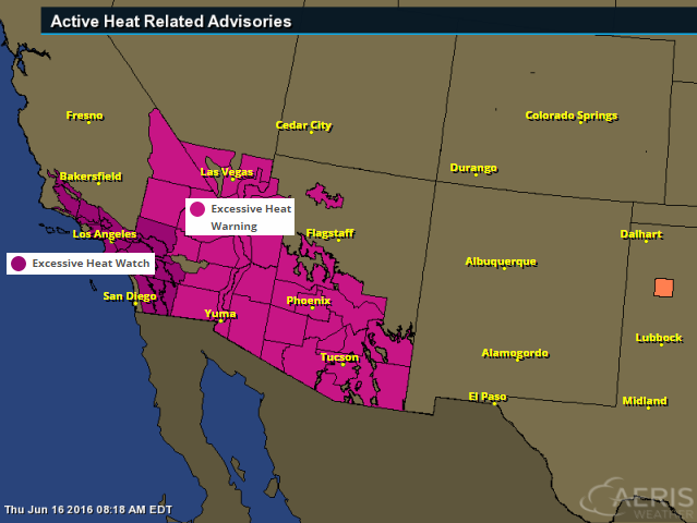
Excessive Heat Watches and Warnings
The
National Weather Service has issued a number of excessive heat watches
and warnings across the Southwest, which includes major cities like Los
Angeles, Las Vegas, Phoenix, Tucson and Yuma.
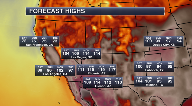
Potential High Temperatures & Stats
Phoenix, AZ- Highs will approach 120 on both Sunday and Monday. Phoenix has only had a high of 120 or higher three times in their recorded history (since 1895).
- The last time Phoenix hit 120 or higher was back on July 28, 1995 when the thermometer hit 121.
- Whether the temperature touches 120 or not, record highs are likely. The current record high each day between Saturday and Tuesday is 115.
Tucson, AZ
- We are calling for a forecast high of 114 on Sunday. Only seven times in Tucson recorded history (since 1894) has the city seen a high of 114 or higher – the last time occurring on July 28, 1995 when it also reached 114.
- The all-time record in Tucson history is 117 set back on June 26, 1990.
- Record highs over the weekend and into next week are 113 Saturday, 112 Sunday, 110 Monday and 112 Tuesday.
Las Vegas, NV
- Las Vegas is no stranger this type of higher heat in the forecast, reaching a temperature of 115 or higher 55 times since 1937. The last time Las Vegas saw a high of 115 or higher was back on July 2, 2013.
- The warmest high ever in Las Vegas history is 117 reached three times in their history. The most recent occurrence was back on June 30, 2013.
- Our forecast has Las Vegas reaching 114 both Monday and Tuesday next week.
- Record highs this weekend into next week are 115 Saturday, 114 Sunday, 113 Monday and 111 Tuesday.
Los Angeles, CA
- Even Los Angeles will get in on the heat this week into early next week, reaching at least the mid 90s Sunday through Tuesday.
- We could even see highs in downtown Los Angeles break the triple-digit mark next Monday. Down toward LAX, highs Monday will be near 90, which could break the record for the day of 86.
(Image and stats courtesy: DJ Kayser @DKayserWX)
__________________________________________
Summer heat surges in for Father's Day weekend
By Todd Nelson, filling in for Douglas.
I
slapped my first mosquito yesterday. Yep. Recent heavy rains and warm
temperatures have created ideal conditions for swarms of skeeters to
attack. Keep in mind that those pesky buggers will likely be more
prevalent around dusk and dawn, so if you're plans take you outdoors
during those times, have the bug spray ready. Happy swatting!By Todd Nelson, filling in for Douglas.
Friday is the first day that our average high in Minneapolis has reached 80 degrees in 2016 and it will be at 80 degrees or warmer through August 23rd. Summer heat and humidity looks to surge back into the Upper Midwest through the weekend with highs approaching 90 degrees by Father's Day. Scattered storms and heavy pockets of rain across northern Minnesota on Saturday will slide south and become a late day threat for the rest of us on Sunday.
Keep in mind that a near full strawberry moon will be visible over the weekend. It will be officially full on Monday, which coincides with the Summer Solstice!
Sure it'll be hot here, but Los Angeles, CA could hit 100 degrees Monday. No thanks
___________________________
Extended Forecast
THURSDAY NIGHT: Mostly clear and quiet with patchy fog Winds: ENE 5mph. Low: 62
FRIDAY: Warmer, more humid. Spotty thunder west. Winds: SE 7-12. High: 85
FRIDAY NIGHT: Partly cloudy. Winds: SE 5. Low: 66.
SATURDAY: Feels like summer. More PM storms N. Winds: S 5-10. High: 86
SUNDAY: Sticky Father's Day. Heavy storms late. Winds: SW 10-20. Wake-up: 68. High: 90
MONDAY: Lingering AM T-storms. Not as muggy. Winds: WNW 10-15. Wake-up: 67. High: 82
TUESDAY: Bright sun, refreshing breeze. Winds: WNW 5-15. Wake-up: 59. High: 77
WEDNESDAY: Comfy. Stray afternoon T-shower? Winds: WSW 5. Wake-up: 59. High: 78
THURSDAY: A touch warmer. Afternoon rumble? Winds: WSW 5-10. Wake-up: 63. High: 81
______________________________
______________________________
This Day in Weather History
June 17th
June 17th
2010:
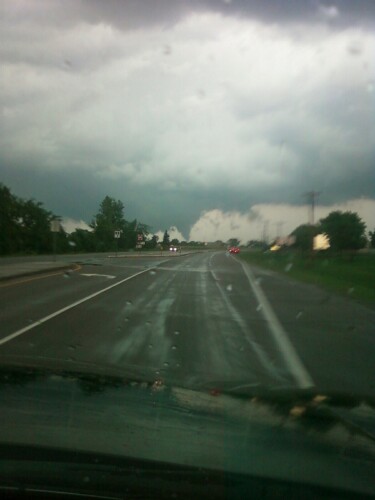
The largest single-day tornado outbreak in Minnesota history occurs
with 48 tornadoes across the state. This outbreak would set the stage
for a record breaking tornado year in Minnesota that finished with 113
tornadoes, the most of any state in the US that year. There were three
EF-4 tornadoes and four EF-3 tornadoes in Minnesota. Four tornado
fatalities occurred, which was the highest daily number since July 5,
1978.
(Tornado near Buffalo, Wright County. Photo credit: Dave Wierstad)
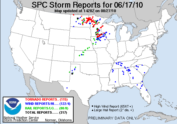
(Storm reports from June 17th, 2010)
_______________________________
Average High/Low for Minneapolis
June 17th
June 17th
Average High: 80F (Record: 97F set in 1933)
Average Low: 60F (Record: 42F set in 1960)
________________________________
Average Low: 60F (Record: 42F set in 1960)
________________________________
Sunrise/Sunset Times for Minneapolis
June 17th
June 17th
Sunrise: 5:26am
Sunset: 9:02pm
Sunset: 9:02pm
*Daylight gained since yesterday: ~16seconds
*Daylight gained since Winter Solstice (December 22nd): ~6hours and 50mins
__________________________________
*Daylight gained since Winter Solstice (December 22nd): ~6hours and 50mins
__________________________________
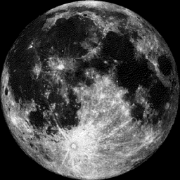
Moon Phase for June 16th at Midnight
2.2 Days Until Full (Strawberry) Moon
2.2 Days Until Full (Strawberry) Moon
____________________________________
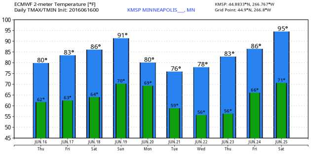
Extended Outlook
More
Heat on the way? Here's the extended forecast depicted from the ECMWF
model, which suggests another hot front arriving on Father's Day Sunday
with high temperatures getting to near 90F! However, it doesn't appear
to last too long as highs much of next week look to settle into the
low/mid 80s.
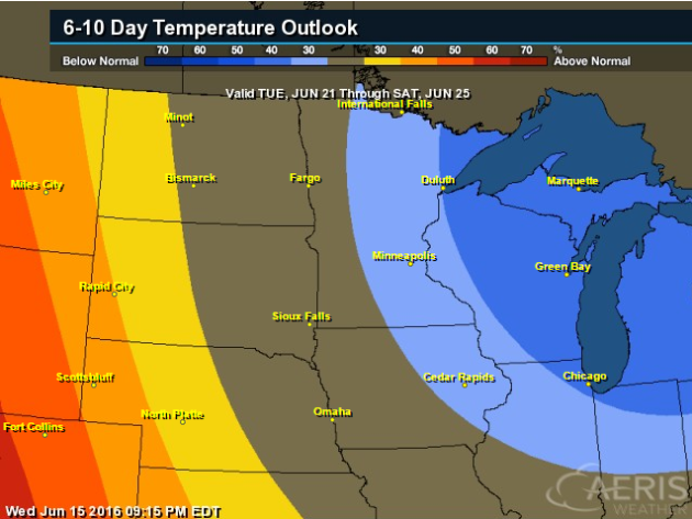
6 to 10 Day Temperature Outlook
According
to NOAA's CPC, the 6 to 10 day temperature outlook suggests a slight
chance of below normal temperatures from June 21st - 25th across the
Great Lakes. As we head into next week, temperatures will like be closer
to where we should be at this time of the year. Side note; the Summer
Solstice is Monday, June 20th!
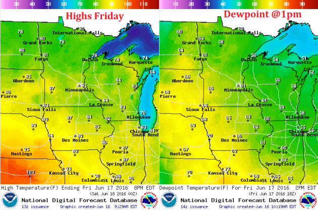
Friday Weather Outlook
High
temperatures across the state on Friday will be a little warmer than
they were on Thursday with a few more 80s showing up across the southern
half of the state. The other thing to note is that dewpoint values will
start to increase as we head into the the weekend, so it'll start
feeling quite a bit more muggy over the coming days.
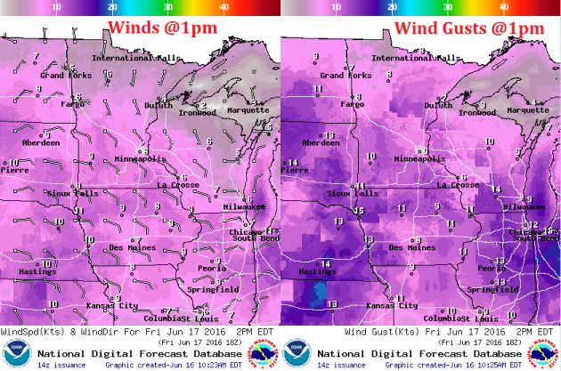
Friday Weather Outlook
An
area of low pressure approaching from the west will allow winds to pick
up out of the east/southeast on Friday, however, wind speeds will stay
fairly light.
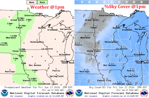
Friday Weather Outlook
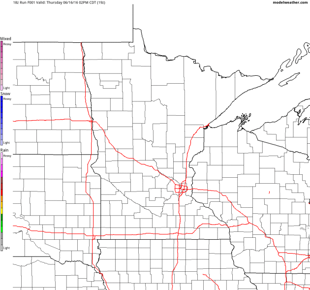
Here's
the weather outlook around midday Friday, which suggests a little light
shower/thunderstorm activity across the eastern Dakotas and parts of
western MN. it appears that this unsettled weather will try to advance
east, but it will run into drier, more stable air and tend to fall
apart, so not much eastward advancement is expected. Most of eastern MN
and WI should see more sun during the day Friday, while a few lingering
showers and storms will be found across parts of western MN.
Simulated Radar
The
simulated radar through Saturday suggests strong storms across the
Dakotas fading as they move into western MN by early Friday. While a few
lingering clouds and rumbles of thunder can't be ruled out on Friday,
most of the heavy rain looks to dissipated before any deeper into
Minnesota. Another round of showers and storms is expected late Saturday
across NW MN and again on Sunday.
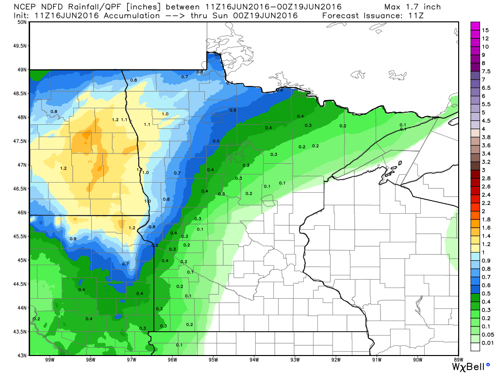
Rainfall Potential
Rainfall
potential through suggests heavier rainfall across NW MN through PM
Saturday. This heavier rainfall potential will be associated with
scattered showers and storms that will be on and off through the
weekend.
___________________________________
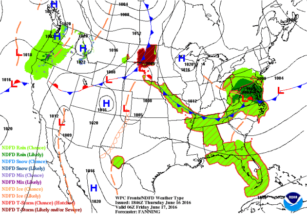
National Weather Outlook
A
storm system moving into the Western U.S. that brought snow to parts of
the northern Sierra Nevada range will wash out a bit through early
weekend. As this happens, dangerous heat begins develop in the Southwest
through early next week. Meanwhile, scattered showers and storms will
be possible across parts of the Midwest and Eastern U.S. through the end
of the week.
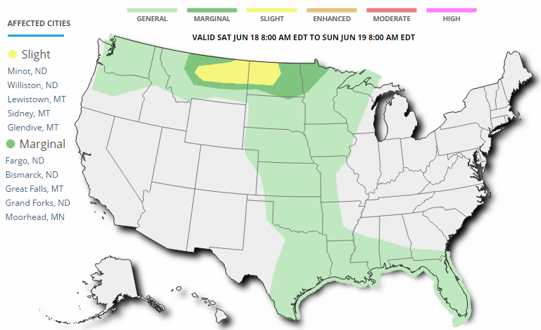
...SUMMARY...
   SCATTERED STRONG TO SEVERE THUNDERSTORMS ARE POSSIBLE FRIDAY ACROSS
   PARTS OF THE SOUTHEAST...AS WELL AS PARTS OF THE NORTHERN ROCKIES
   INTO THE NORTHERN PLAINS.
...PARTS OF THE NORTHERN PLAINS TO UPSLOPE REGIONS OF NORTHERN HIGH
   PLAINS...
   MODELS CONTINUE TO INDICATE THE RISK FOR GENERALLY ISOLATED STRONG
   TO SEVERE STORM DEVELOPMENT IN DEVELOPING EAST/SOUTHEASTERLY
   LOW-LEVEL UPSLOPE FLOW...CLOSER TO THE HIGHER TERRAIN LATE FRIDAY
   AFTERNOON AND EVENING.  STRONGER MID-LEVEL FLOW...AND DEEP LAYER
   SHEAR...WILL BE CONFINED TO PARTS OF MT/WY AND ND.  STORMS SHOULD BE
   ONGOING ACROSS PARTS OF ND INTO NORTHWEST MN AND PERHAPS NORTHEAST
   SD.

   A COLD FRONT MOVING ACROSS THE NORTHERN PLAINS TODAY SHOULD STALL
   FROM NORTHWEST MN THROUGH EASTERN SD TO WESTERN NEB BY FRIDAY
   AFTERNOON.  ALTHOUGH FORCING ALOFT WILL BE RELATIVELY WEAK...
   CONVERGENCE ALONG THIS FRONT /ESPECIALLY AT THE INTERSECTION OF ANY
   LEFT OVER CONVECTIVE BOUNDARIES FROM DAY 1/ MAY PROVE SUFFICIENT FOR
   NEW STORM INITIATIONS.  THIS LIKELIHOOD WILL BE ENHANCED BY VERY
   STRONG INSTABILITY /MUCAPE 3000-4500 J PER KG/...WITH SOME DRY AIR
   ABOVE THE BOUNDARY LAYER SUPPORTING AT THREAT FOR ISOLATED DAMAGING
   WIND GUSTS.  FOR THESE REASONS...THE MARGINAL SEVERE-WEATHER RISK
   HAS BEEN EXTENDED TO THE NORTHEAST THROUGH SOUTHERN/EASTERN SD TO
   FAR SOUTHEAST ND AND WEST-CENTRAL/SOUTHWEST MN.
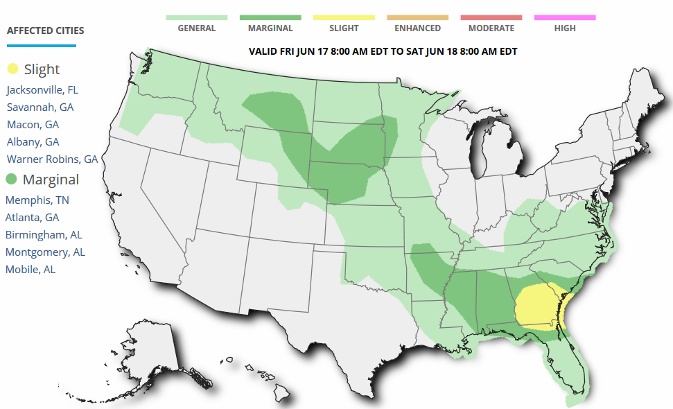
Severe Threat Saturday
...SUMMARY...
   THUNDERSTORMS CAPABLE OF PRODUCING LARGE HAIL AND STRONG SURFACE
   WIND GUSTS ARE POSSIBLE LATE SATURDAY AFTERNOON INTO SATURDAY
   NIGHT...ACROSS PARTS OF CENTRAL THROUGH NORTHEAST MONTANA...INTO
   PORTIONS OF WESTERN AND CENTRAL NORTH DAKOTA.

   ...SYNOPSIS...
   A SIGNIFICANT SHORT WAVE IMPULSE WITHIN A NORTHERN BRANCH OF SPLIT
   WESTERLIES APPEARS LIKELY TO CONTINUE TO GRADUALLY FLATTEN UPPER
   RIDGING ACROSS CENTRAL INTO EASTERN CANADA DURING THIS PERIOD.  AS
   THIS OCCURS...PROMINENT SUBTROPICAL RIDGING...CENTERED OVER THE
   SOUTHERN ROCKIES BY THE BEGINNING OF THE PERIOD...MAY ELONGATE
   EASTWARD ALONG AN AXIS ACROSS THE CENTRAL PLAINS AND MIDDLE
   MISSISSIPPI VALLEY...TOWARD THE MID ATLANTIC COAST.  ON THE
   NORTHWESTERN PERIPHERY OF THIS RIDGE...THE REMNANTS OF A CLOSED LOW
   MIGRATING INTO THE PACIFIC NORTHWEST ARE EXPECTED TO BECOME
   INCREASINGLY DEFORMED/SHEARED WHILE CONTINUING INLAND ACROSS THE
   WESTERN INTERNATIONAL BORDER AREA.

   IN RESPONSE TO THESE DEVELOPMENTS...A MODEST SURFACE LOW IS EXPECTED
   TO DEVELOP ACROSS SOUTH CENTRAL INTO SOUTHEASTERN MONTANA...AHEAD OF
   ANOTHER COLD FRONT ADVANCING INTO/ACROSS THE NORTHERN ROCKIES.  BY
   LATE SATURDAY INTO SATURDAY NIGHT...A WARM FRONT PROBABLY WILL
   STRENGTHEN TO THE EAST OF THE  LOW...ACROSS THE DAKOTAS.
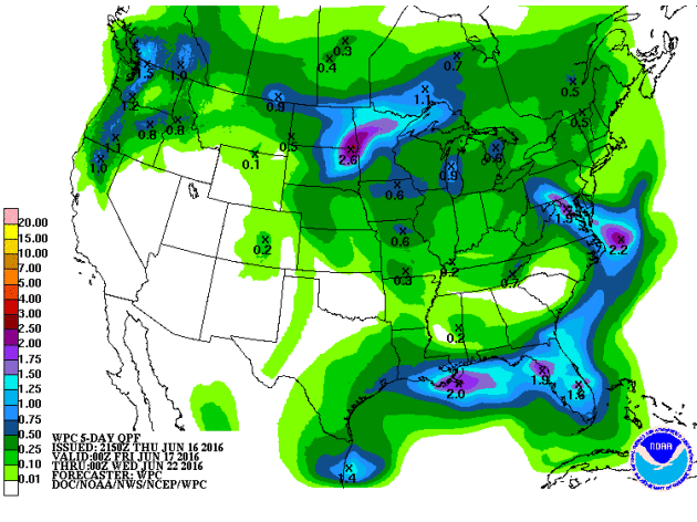
5 Day Rainfall Potential
According
to NOAA'S WPC, the 5 day rainfall forecast suggests heavier pockets of
rain across parts of the northern tier of the nation through the
Mid-Atlantic states and into the Southeastern U.S.. Keep in mind that
with thunderstorm activity, some locations could see 1" to 2"+ through
the end of the weekend.
__________________________________
"Climate Impacts From Farming Are Getting Worse"
As
signs emerge that the global energy sector is beginning to rein in what
once had been unbridled levels of climate-changing pollution, new
United Nations figures show pollution from farming is continuing to get
worse. Greenhouse gases released from the growing of crops and livestock
directly increased by a little more than 1 percent in 2014, compared
with a year prior, the newly updated data shows. Burning
fossil fuels for energy grew by about half that amount during the same
period, research published in December showed, with further reductions
anticipated for 2015. That’s seen as a key first step toward achieving
the vast pollution reductions needed to start to stabilize the climate. “Historically,
it’s been the opposite — fossil fuel emissions have grown exponentially
and agricultural emissions have grown linearly,” said Francesco
Tubiello, a team leader in the statistics division of the Food and
Agriculture Organization of the United Nations, which compiles the data.
("Dairy
cows are a major source of methane pollution, which heats the
atmosphere faster than carbon dioxide." Credit: John Upton)

_________________________________________________
"The Mosaic-Tailed Rat From The Great Barrier Reef Is Now Extinct Due To Climate Change"
"The first mammal wiped out from climate change is an Australian rat that lived on a tiny island on the Great Barrier Reef. Bramble
Cay is so small, it's not technically an island, but a cay, at 340m by
150m which is a 20-minute walk from end to end or about the size of
three Melbourne Cricket Grounds. In
a report released in June 2016 by the Queensland Government and the
University of Queensland, researchers found the last anecdotal sighting
of the rat was from fishermen in the area in 2009. The
report found climate change-exacerbated sea level rise seriously
impacted the island, which was only 3m above sea level at its highest
point, and the presumption is that the cay was temporarily submerged,
killing the rats."
(DAVID CARTER / DEPARTMENT OF ENVIRONMENT AND HERITAGE PROTECTION)

______________________________________________
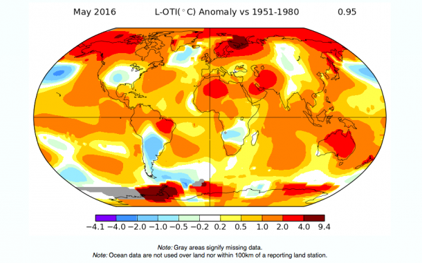
"Global climate experiencing 'fundamental change' says UN"
The
global climate is undergoing "fundamental change" with abnormal weather
conditions becoming the "new normal", the United Nations warned on
Tuesday, as the month of May was declared the hottest on record. The
northern hemisphere also experienced the hottest spring on record,
including heavy rain across much of Europe, according to the World
Meteorological Organisation (WMO), a Geneva-based branch of the
UN. Meanwhile, the Arctic ice cap began melting unusually early. By
March, the ice was disappearing at rates not normally seen until July. The
average temperature in May was 0.95 degrees centigrade higher than the
average recorded between 1951 and 1980, while the world had now seen 370
consecutive months of warm or warmer than average temperatures, the
agency said. “The state of the
climate so far this year gives us much cause for alarm,” said Dr David
Carlson, the director of the Climate Research Programme at the WMO. “The
super El Niño is only partly to blame. Abnormal is the new normal.”
_________________________________________
Thanks for checking in and don't forget to follow me on Twitter @TNelsonWX

No comments:
Post a Comment