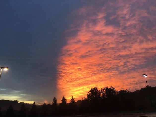
Thanks to Susie for this picture out of Eden Prairie after the storms cleared on Tuesday evening. Much of southern Minnesota had strong to severe thunderstorms with heavy rainfall.
Here are the storm reports from Tuesday and note that there were nearly a dozen tornado and or funnel cloud reports on Tuesday, most of which were in southern MN.

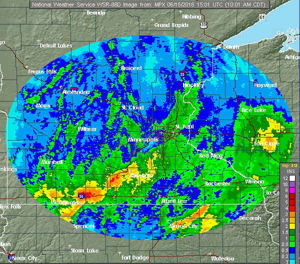
Heavy Rainfall
Scattered
showers and storm on Tuesday dropped heavy rainfall across parts of the
state. Take a look at the radar estimated rainfall from Tuesday and
note how widespread the near 1" (green colors) were. Also note the near
2" to 4"+ estimates across southern MN!
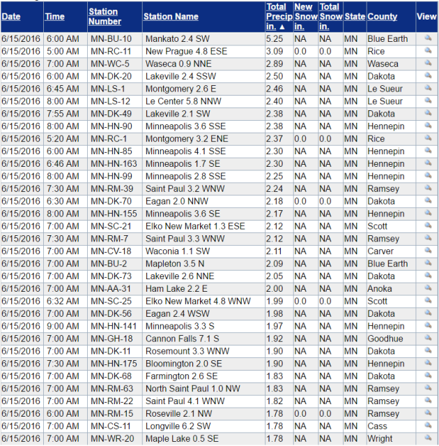
CoCoRaHS Rainfall Reports
Here are some of CoCoRaHS reports from Tuesday, which show several 1" to 2"+ amounts with the heaviest near Mankato with 5.25"!!
________________________________________
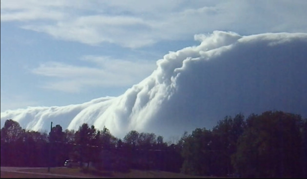
This video was taken from the Sleeping Bear Heritage Trail, which currently runs 16 miles from Empire, MI to Port Oneida, MI. The amazing cloud is a Kelvin-Helmholtz cloud, formed when two different layers of air in our atmosphere are moving at different speeds, making the cloud roll like a wave. After this long, narrow cloud passed, the sky was blue!
See the video from Sleeping Bear Dunes National Lakeshore Facebook HERE:
__________________________________________
By Todd Nelson
I'd have to say that this is by far my favorite time of the year. Long days, warm nights, rumbles of thunder and a green garden. However, I feel like I can't slow Mother Nature's sprint.
Get this, we're only a few days away from the Summer Solstice (Monday, June 20th). On that day, when the sun's most direct rays are shining over the the Tropic of Cancer at 23.5 degrees latitude north, we peak at around 15 and a half hours of daylight; almost 7 hours more daylight than on the Winter Solstice (Dec. 22). I feel good until the 4th of July, but then we hit the summer slide. Dwindling daylight and the "Dog Days of Summer". With that said, enjoy the summer weather while you can!
Thursday will be a fine day with lighter winds, lower humidity values and bright sun! A storm system approaching slowly from the west will bring spotty showers and storms to western and northwestern Minnesota late Friday and Saturday. Father's Day looks hot and sticky with a late day thunder threat.
Meanwhile, Phoenix AZ could hit 120° by Sunday - WHEW!
___________________________
Extended Forecast
WEDNESDAY NIGHT: Mostly cloudy and more comfortable. Low: 60. Winds: WNW 5.
THURSDAY: Plenty of sunshine, less humid. Winds: ESE 7-12. High: 79.
THURSDAY NIGHT: Mostly clear and quiet. Winds: ESE 5mph. Low: 63
FRIDAY: Warmer, more humid. PM storms west. Winds: ESE 5-10. High: 84
SATURDAY: Feels like summer. Late day rumble. Winds: S 10-20. Wake-up: 63. High: 85
SUNDAY: Muggy Dad's day. Scattered PM storms Winds: SSW 10-15. Wake-up: 69. High: 88
MONDAY: Summer begins. Lingering T-showers. Winds: NNW 5-10. Wake-up: 68. High: 80
TUESDAY: Mostly sunny, refreshing breeze. Winds: NNW 5-10. Wake-up: 60. High: 77
WEDNESDAY: Partly cloudy and mild. Winds: W 5. Wake-up: 61. High: 80F
______________________________
This Day in Weather History
June 16th
1992: A total of 27 tornadoes touch down across Minnesota, the second most in Minnesota history. The communities of Chandler, Lake Wilson, Clarkfield and Cokato are badly damaged. 80 million dollars worth of damage would occur, and Presidential disaster declarations would be made for many counties.
1989: Frost develops across Minnesota with crops destroyed on high ground in southeast Minnesota. Preston got down to 32.
_______________________________
Average High/Low for Minneapolis
June 16th
Average High: 79F (Record: 97F set in 1933)
Average Low: 59F (Record: 43F set in 1951)
________________________________
Sunrise/Sunset Times for Minneapolis
June 16th
Sunrise: 5:26am
Sunset: 9:02pm
*Daylight gained since yesterday: ~20seconds
*Daylight gained since Winter Solstice (December 22nd): ~6hours and 50mins
__________________________________
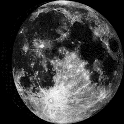
Moon Phase for June 16th at Midnight
4.2 Days Until Full (Strawberry) Moon
Extended Outlook
More Heat on the way? Here's the extended forecast depicted from the ECMWF model, which suggests another hot front arriving on Father's Day Sunday with high temperatures getting to near 90F! However, it doesn't appear to last too long as highs much of next week look to settle into the low/mid 80s.

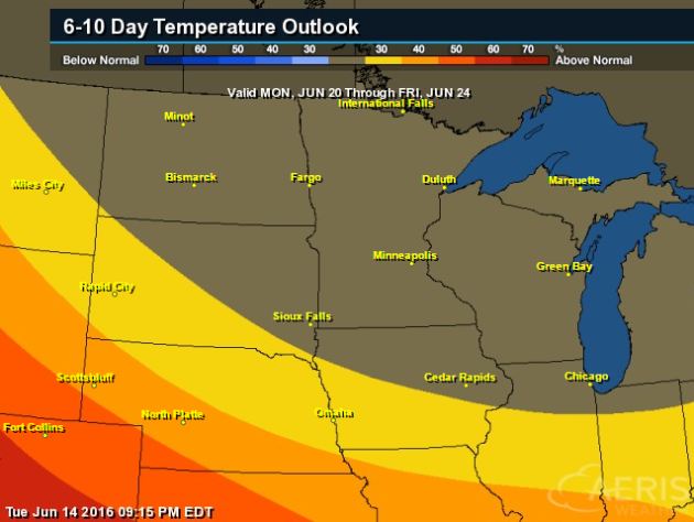
According to NOAA's CPC, the 6 to 10 day temperature outlook suggests equal chances of above and below normal temperatures from June 20th - 24th. So, as we head into next week, temperatures will like be closer to where we should be at this time of the year. Side note; the Summer Solstice is Monday, June 20th!
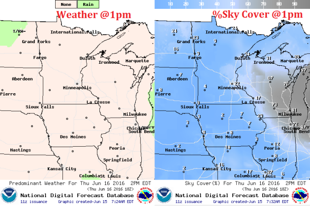
Thursday Weather Outlook
High temperatures across the state on Thursday don't look to terribly warm. In fact, we should be pretty close to average for mid June with highs in the 70s and low 80s. However, note that readings closer to Lake Superior will be much cooler with a wind off the lake. Dewpoints won't be too sticky either as most of us hover in the 50s to near 60s.
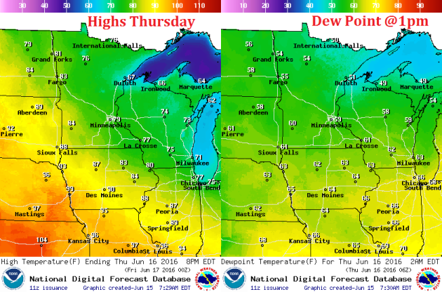
Winds on Thursday won't be a problem either as most of us will see a 5 to 10 mph wind out of the east. Wind gusts could be a little stronger across the western part of the state during the afternoon in advance of another storm system that may kick out spotty thunder later this week/weekend across the Dakotas.
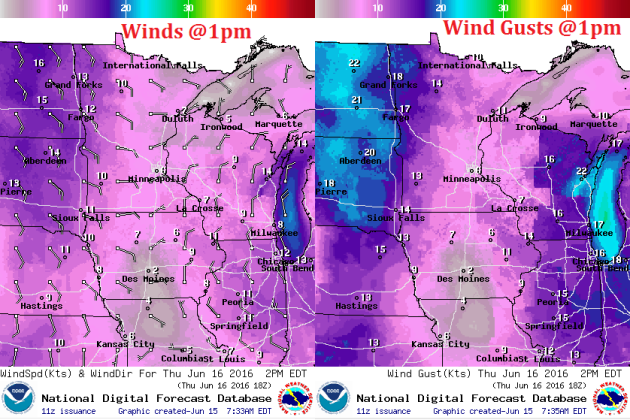
After a fairly cloudy day Wednesday, Thursday should feature more sunshine and lighter winds. With highs near average, dewpoints fairly comfortable and plenty of sunshine, Thursday should be a pretty nice day! Enjoy!
Here's the simulated radar into the early weekend timeframe, which suggests fairly quiet weather Thursday and much of Friday except across far western Minnesota. The next best chance of showers and storms doesn't look to arrive until the second half of the weekend... Stay tuned.

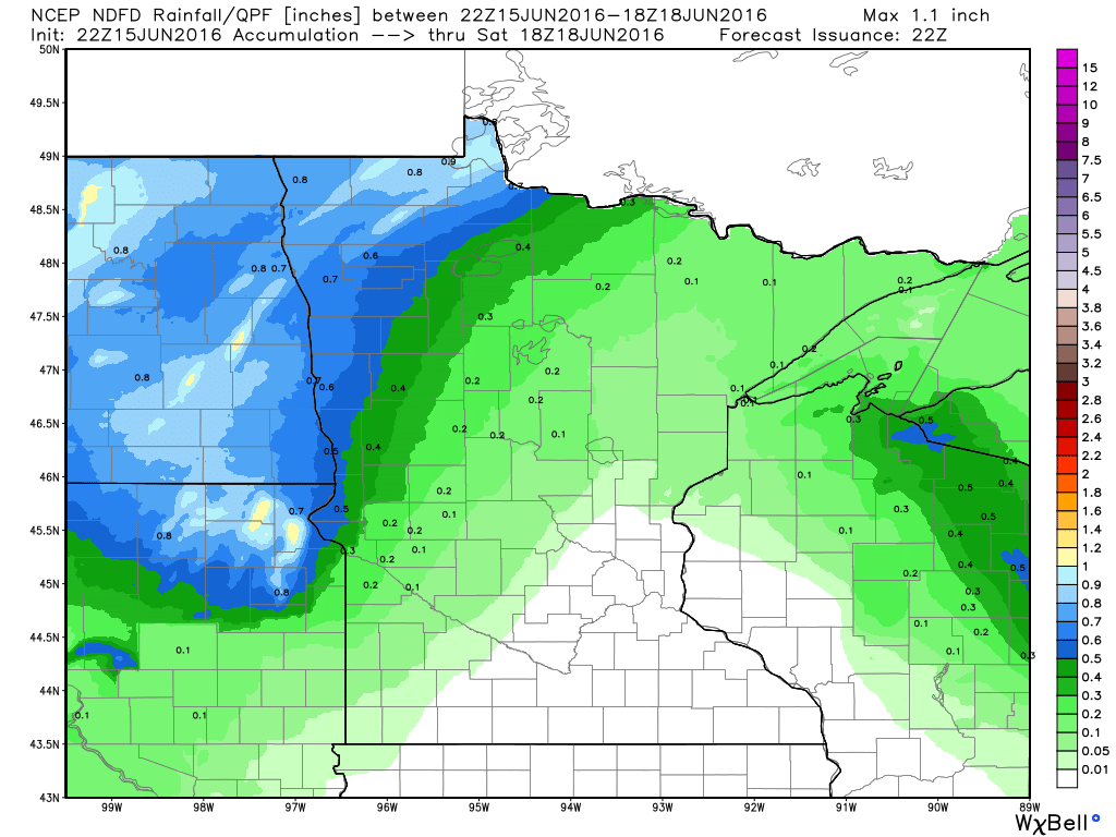
Rainfall potential through midday Sunday doesn't look at that impressive with most spots staying dry. It appears that only up to a couple of tenths of an inch of rain may be possible across far northern Minnesota through the end of the week.
___________________________________
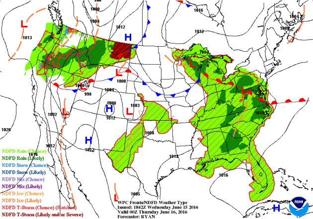
National Weather Outlook
While hot temperatures continue to take up residency in the Central U.S., scattered showers and storms will continue to erupt on the outer periphery of this hot dome over the next few days. Note that most of the rainfall will be found from the Northwest to the Midwest and back down through the Mid-Atlantic states.
...SUMMARY...
   THE GREATEST POTENTIAL FOR SEVERE STORMS THURSDAY INTO THURSDAY
   NIGHT IS ACROSS PARTS OF THE OHIO VALLEY INTO THE CENTRAL AND
   SOUTHERN APPALACHIANS AND PORTIONS OF THE SOUTHERN MID-ATLANTIC
   STATES.

   ...SYNOPSIS...
   MODELS REMAIN CONSISTENT WITH THE EVOLUTION OF THE SYNOPTIC PATTERN
   THIS FORECAST PERIOD.  AS INDICATED IN THE INITIAL DAY 2 OUTLOOK...A
   SUBTROPICAL HIGH CENTER SHOULD BECOME MORE PROMINENT WITHIN THE
   LARGER-SCALE RIDGING...ACROSS THE NORTHERN MEXICAN PLATEAU AND
   ADJACENT PORTIONS OF SOUTHERN AZ/NM AND SOUTHWEST TX.  500-MB
   HEIGHTS WILL RISE ACROSS THE NORTHERN EXTENT OF THE NORTH AMERICAN
   RIDGE THROUGH NORTHERN ONTARIO TO HUDSON BAY...AS A SHORTWAVE TROUGH
   BECOMES MORE PROGRESSIVE ON THURSDAY...TRACKING FROM THE GREAT LAKES
   TO THE CENTRAL APPALACHIANS/MID-ATLANTIC REGION.  LARGE-SCALE TROUGH
   DEVELOPMENT IS EXPECTED ACROSS THE EASTERN STATES WHILE A LARGE
   TROUGH REMAINS POSITIONED FROM THE NORTHEAST PACIFIC TO WESTERN
   CANADA.

   AT THE SURFACE...AN INITIALLY STALLED FRONT EXTENDING FROM CENTRAL
   PA THROUGH NORTHERN MD TO THE DELMARVA PENINSULA IS EXPECTED TO
   ADVANCE TO THE WEST AS A COLD FRONT.  THIS WILL BE SUPPORTED BY
   WINDS BECOMING EASTERLY TO THE EAST AND NORTH OF THIS FRONT ACROSS
   THE NORTHERN MID-ATLANTIC REGION...AS A SURFACE LOW SHIFTS AWAY FROM
   THE VA COAST.  MEANWHILE...A SURFACE LOW ATTENDANT TO THE GREAT
   LAKES SHORTWAVE TROUGH WILL SHIFT SOUTHEAST ALONG THE COLD
   FRONT...WITH THIS BOUNDARY FORECAST TO EXTEND FROM FAR NORTHERN TO
   SOUTHEAST VA BY LATE THURSDAY AFTERNOON.  A COLD FRONT TRAILING THE
   GREAT LAKES/UPPER OH VALLEY LOW WILL ADVANCE SOUTH ACROSS THE OH/MID
   MS INTO THE TN VALLEYS.  THE WESTERN FLANK OF THIS COLD FRONT
   TRAILING THE SURFACE LOW IS EXPECTED TO REMAIN QUASI-STATIONARY
   ACROSS PARTS OF THE MIDDLE MISSOURI VALLEY INTO THE NORTHERN
   PLAINS...AHEAD OF ANOTHER COLD FRONT ADVANCING TO THE EAST OF THE
   NORTHERN ROCKIES.  THE PORTION OF THIS LATTER FRONT ACROSS THE
   INTERMOUNTAIN WEST SHOULD REMAIN STALLED...GIVEN GENERALLY
   FRONT-PARALLEL DEEP-LAYER WIND FIELDS.
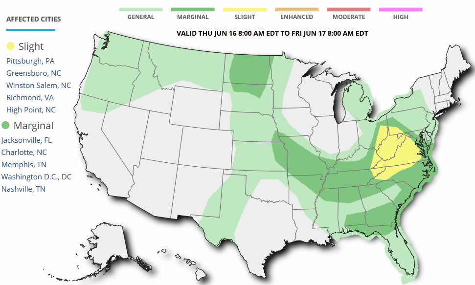
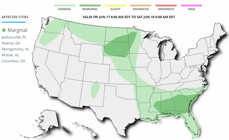
Severe Threat Friday
...SUMMARY...
   THUNDERSTORMS MAY IMPACT PARTS OF THE SOUTHEAST...AS WELL AS
   PORTIONS OF THE NORTHERN PLAINS...ON FRIDAY...WITH SOME RISK FOR
   SEVERE WEATHER.

   ...SYNOPSIS...
   MODELS INDICATE THAT AN INCREASINGLY PROMINENT SUBTROPICAL HIGH WILL
   BECOME CENTERED OVER NEW MEXICO DURING THIS PERIOD...WITHIN
   LARGER-SCALE RIDGING EXTENDING ALONG AN AXIS NORTHEASTWARD ACROSS
   THE UPPER GREAT LAKES REGION INTO ONTARIO AND QUEBEC.  IT APPEARS
   POSSIBLE THAT AN IMPULSE MAY EMERGE FROM THE ROCKIES ON THE
   PERIPHERY OF THIS FEATURE...BEFORE MIGRATING NORTHEASTWARD ACROSS
   THE DAKOTAS LATE FRIDAY INTO FRIDAY NIGHT.  AT THE SAME TIME...A
   BROAD CLOSED LOW WITHIN LARGER-SCALE UPSTREAM TROUGHING MAY CONTINUE
   TO EDGE EAST NORTHEASTWARD ACROSS THE NORTHERN PACIFIC COAST.

   DOWNSTREAM...SHARP...POSITIVELY TILTED...MID/UPPER TROUGHING IS
   FORECAST TO GRADUALLY SHIFT EAST OF THE ATLANTIC COAST.  THE MAIN
   IMPULSE WITHIN THE SOUTHWESTERN PERIPHERY OF THIS REGIME MAY TURN
   EASTWARD OFF THE SOUTHERN MID ATLANTIC COAST BY EARLY
   AFTERNOON...BUT WEAK TROUGHING MAY LINGER ACROSS PARTS OF THE
   SOUTHEAST THROUGH MUCH OF THE PERIOD.  AN ASSOCIATED SURFACE COLD
   FRONT APPEARS LIKELY TO ADVANCE FROM THE TENNESSEE VALLEY AND
   SOUTHERN MID ATLANTIC COAST STATES INTO NORTHERN FLORIDA AND CENTRAL
   GULF COASTAL AREAS BY EARLY SATURDAY.
5 Day Rainfall Potential
According to NOAA'S WPC, the 5 day rainfall forecast suggests heavier pockets of rain across parts of the northern tier of the nation through the Mid-Atlantic states and into the Southeastern U.S.. Keep in mind that with thunderstorm activity, some locations could see 1" to 2"+ through the end of the weekend.

___________________________________
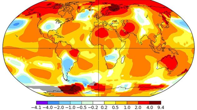
"Earth's hot streak continues with warmest May since at least 1880"
"Another month, another shattered global temperature record. According to preliminary readings from NASA, May 2016 was the warmest such month on record for the planet, dating back to 1880. Global average surface temperatures were 0.93 degrees Celsius, or 1.67 degrees Fahrenheit, above average for the month, beating out the old record, which was set in May 2014. This makes May the 8th straight warmest month on record in NASA's database. According to the World Meteorological Organization, it was also the warmest northern hemisphere spring on record, in part due to much milder than average conditions in the Arctic. If the National Oceanic and Atmospheric Administration (NOAA) also ranks May as the warmest such month, it would make it the 13th straight warmest month in NOAA's records, which has never happened before. (Although the two agencies use similar data, they differ in how they analyze global temperature measurements.)"
See more from Mashable.com HERE:
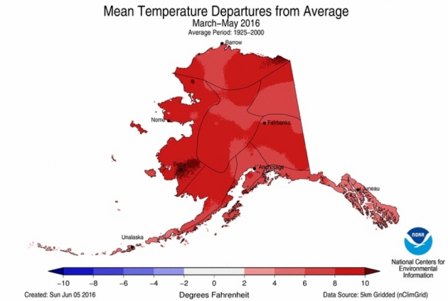
"Alaska Continues to Bake, on Track For Hottest Year"
"Alaska
just can’t seem to shake the fever it has been running. This spring was
easily the hottest the state has ever recorded and it contributed to a
year-to-date temperature that is more than 10°F (5.5°C) above average,
according to data released Wednesday by the National Oceanic and
Atmospheric Administration.The Lower 48, meanwhile, had its warmest
spring since the record-breaking scorcher of 2012.While May as a whole
was only slightly above average — thanks in part to whiplashing weather
from the beginning of the month to the end — every state in the
contiguous U.S. had warmer-than-normal temperatures for the spring as a
whole."
______________________________________________
And So It Begins: Weather Market 2016
 ________________________________________________
No comments:
Post a Comment