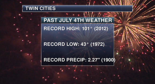
Independence Day Climatology
Happy
Fourth of July! While you continue to enjoy the almost
too-good-to-be-true weather we've had this holiday weekend, lets take a
look back at some past Fourth of July weather. First, 15% of July 4ths
since 1872 have seen a high of 90 or above, with a 100+ high only
occurring twice. The warmest was only four years ago in 2012 when the
thermometer reached 101. The coolest start to the day we've had on July
4th was back in 1972 with a low of 43. The wettest was when 2.27" of
rain fell in 1990. About 41% of the Fourth of July's on record for the
Twin Cities have seen measurable rainfall (more than a trace) at some
point during the day.
_______________________________________________
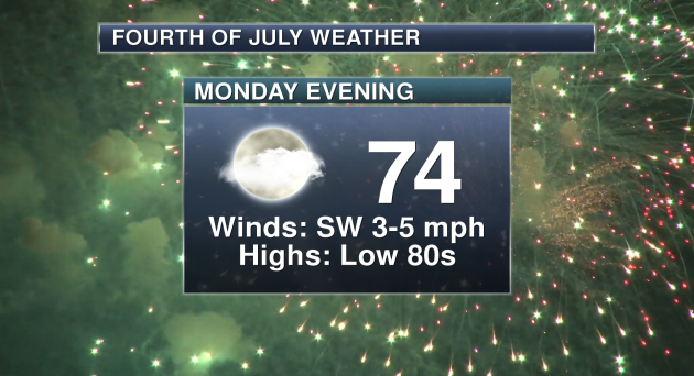
Twin Cities Fourth of July Planner
This
Fourth of July looks spectacular across the Twin Cities, with partly
cloudy skies and highs climbing into the low 80s. By the time fireworks
go off during the evening, winds will be out of the southwest at 3-5 mph
with temps in the low to mid 70s.
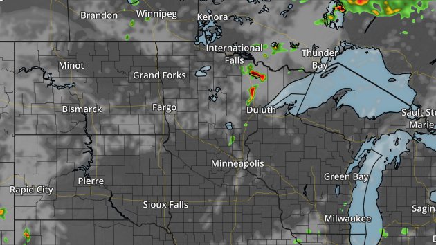
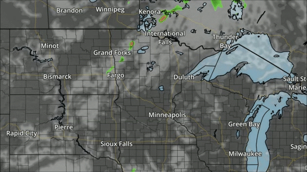
Here's
a look at 10 PM Monday night - about the time many fireworks shows will
be ongoing across the region. We will see a partly cloudy sky across
much of southern Minnesota, with the best chance of any storms over
northern Minnesota. Here's hoping the firework shows go off without a
hitch - especially weatherwise!
_______________________________________________
Past July Weather
We
are now halfway through the year - can you believe that? Which
*typically* means it's time for the heat to settle in across the region,
unlike the lows in the 30s parts of northern Minnesota saw Friday
morning. I thought I would take a look at where our typical records are
for the seventh month of the year - and while it can be warm, it can
also be quite cool this time of year across the region.
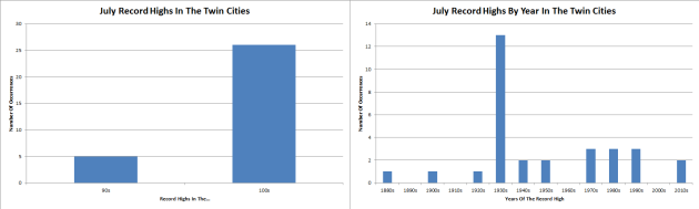
First,
we'll take a look at record highs. Did you know that only five days
during the month of July have never hit 100 over the 100+ years of data
there is for the Twin Cities? The "coolest" record highs of the month
are on the following days: 2nd (99), 9th (99), 17th (99), 25th (99), and
the 29th (98). The warmest record of the month - and the warmest day
ever recorded in the Twin Cities - was back on July 14th, 1936, when the
mercury hit 108. This was during the stretch of Minnesota's worst heat
wave, something we'll talk about more in a minute. Only two of the
current record highs for the month of July have occurred since 2000 -
both in 2012 - on the 2nd (99) and the 4th (101).
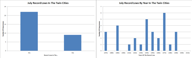
On
the cooler side of things, 22 of the current monthly lows are in the
40s - the coolest morning being July 4th of 1972, when the low was 43.
None of the current record lows on record were set in the 21st century.
The most recent July record low was set back on the 10th of 1996, when
the thermometer dropped to 49 in the Twin Cities.
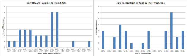
While
July holds the warmest day in Twin Cities history, it also holds the
wettest day. This year will mark the 29th anniversary of the Twin Cities
Superstorm, in which 9.15" of rain fell on July 23rd, 1987, causing
major flooding across the Twin Cities. Meanwhile, the easiest record to
break is at the end of the month, when 0.79" of rain fell on the 31st of
1911.
_______________________________________________
80th Anniversary of the 1936 Heat Wave
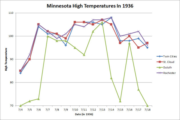
This
week marks the 80th anniversary of the worst heat wave in Minnesota
history back in 1936, when highs for a good majority of 1-2 weeks were
in the 100s across the region. Many of these records still are in place
today, and this heat wave brought the warmest high ever record in the
Twin Cities - 108 degrees on July 14th. Not only was the warmest
temperature on record at the Twin Cities recorded during this stretch,
but at St. Cloud (107 on the 13th which is also tied with two days from
1934), Duluth (106 on the 13th), and Rochester (108 on the 14th) as
well. The warmest Minnesota temperature on record was also tied in this
heat wave, when it reached 114 on July 6th, 1936 in Moorhead.
Here's a recap of the heat wave from Mark Seeley's WeatherTalk blog: "It
started in southern counties on July 4, 1936 with many observers
reporting daytime temperatures over 100F. The Heat Wave spread north
over the next 12-15 days. Even northern communities reported
temperatures close to 100F, and nighttime temperatures remained in the
80s F in many areas, falling into the 70s F near lakes and in low lying
areas. There was no respite from the heat, as many citizens chose to
sleep outside. It is estimated that this Heat Wave caused over 900
deaths in Minnesota and at least 5000 deaths across the nation. It was
also combined with serious drought."
_______________________________________________
Declaring Independence from Lousy Holiday Weather
By Paul Douglas
"For what avail the plough or sail, or land or life, if freedom fail?" asked Ralph Waldo Emerson. Minnesotans are stunned; meteorologists at a rare and welcome loss for words. The weather maps are miraculously quiet. Doppler is turned off. No tropical deluges, dock-ripping winds or burrito-size hail to track. The 4th of July usually brings storms and steamy dew points. This year we get a touch of September with low 80s, a light south breeze, and with the possible exception of far northern Minnesota, an absence of thunderstorms for evening fireworks displays.
"For what avail the plough or sail, or land or life, if freedom fail?" asked Ralph Waldo Emerson. Minnesotans are stunned; meteorologists at a rare and welcome loss for words. The weather maps are miraculously quiet. Doppler is turned off. No tropical deluges, dock-ripping winds or burrito-size hail to track. The 4th of July usually brings storms and steamy dew points. This year we get a touch of September with low 80s, a light south breeze, and with the possible exception of far northern Minnesota, an absence of thunderstorms for evening fireworks displays.
Storms sprout Tuesday afternoon along an approaching warm front; sticky humidity and swarms of storms linger into Thursday
before a slight drop in temperature and dew point by next weekend. The
extended outlook into July is warm, but I see no sign of any
debilitating heat waves setting up close to home.
Feeling
lucky? I sure am. West Virginia is recovering from a 1 in 1,000 year
flood, parts of the west are on fire, and neon-green, toxic algae is
choking south Florida's coastline.
The North Woods are looking even better.
_______________________________________________
Extended Forecast for Minneapolis
MONDAY: Warm sunshine. High 83. Low 67. Chance of precipitation 10%. Winds S 8-13 mph.
TUESDAY: Sticky, PM T-storms may be severe. High 86. Low 66. Chance of precipitation 60%. Winds SW 8-13 mph.
WEDNESDAY: Drying out, still sticky. High 85. Low 71. Chance of precipitation 10%. Winds NE 8-13 mph.
THURSDAY: More showers and T-storms. High 83. Low 66. Chance of precipitation 60%. Winds E 8-13 mph.
FRIDAY: Sunny peeks, few instability showers. High 81. Low 61. Chance of precipitation 50%. Winds NW 10-15 mph.
SATURDAY: Partly sunny, less humid. High 77. Low 58. Chance of precipitation 10%. Winds NE 7-12 mph.
SUNDAY: Plenty of sun, a bit milder. High 81. Low 63. Chance of precipitation 10%. Winds SE 7-12 mph.
_______________________________________________
Sunset: 9:02 PM
*Length Of Day: 15 hours, 29 minutes and 53 seconds
*Daylight Lost Since Yesterday: ~0 mins & 57 secs
*Next Sunrise That Is Before 6 AM: August 3rd (6:01 AM)
*Next Sunset That Is Before 9 PM: July 11th (8:59 PM)
Monday (Independence Day) And Beyond Minnesota Weather Outlook
This Day in Weather History
July 4th
July 4th
1999: Severe winds knock down millions of trees in the BWCA, injuring 19 people. Click for more information on the Fourth of July derecho from the SPC.
1977: Winds of 80-100 mph blasted parts of central Minnesota, causing thousands of dollars in damage. Read more on the July 4, 1977 derecho from the SPC.
1962: An extremely heavy downpour falls at Jackson, dumping 7.5 inches of rain in two hours.
1977: Winds of 80-100 mph blasted parts of central Minnesota, causing thousands of dollars in damage. Read more on the July 4, 1977 derecho from the SPC.
1962: An extremely heavy downpour falls at Jackson, dumping 7.5 inches of rain in two hours.
_______________________________________________
Average Temperatures & Precipitation for Minneapolis
July 4th
July 4th
Average High: 83F (Record: 101F set in 2012)
Average Low: 64F (Record: 43F set in 1972)
Average Precipitation: 0.13" (Record: 2.27" set in 1900)
________________________________________________
Average Low: 64F (Record: 43F set in 1972)
Average Precipitation: 0.13" (Record: 2.27" set in 1900)
________________________________________________
Sunrise/Sunset Times for Minneapolis
July 4th
Sunrise: 5:33 AMJuly 4th
Sunset: 9:02 PM
*Length Of Day: 15 hours, 29 minutes and 53 seconds
*Daylight Lost Since Yesterday: ~0 mins & 57 secs
*Next Sunrise That Is Before 6 AM: August 3rd (6:01 AM)
*Next Sunset That Is Before 9 PM: July 11th (8:59 PM)
________________________________________________
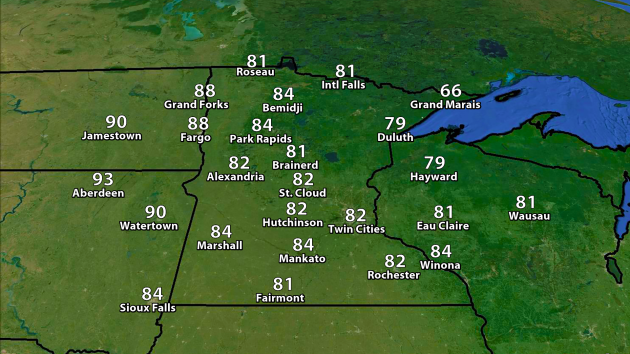
Highs
for the Fourth of July will range in the 70s and 80s across much of the
state of Minnesota, with the coolest weather occurring in the northeast
portion of the state, where places like Grand Marais may not make it
out of the 60s. However, if your travels take you west during the day
Monday, highs will climb into the 90s across parts of the Dakotas.
 NAM forecast clouds and precipitation every three hours between 7 am Monday and 7 am Tuesday.
The
only weather concern across the state Monday will likely be in northern
Minnesota, where some storms may be possible. Otherwise, we're expected
a mix of clouds and sun across the rest of the state for the holiday!
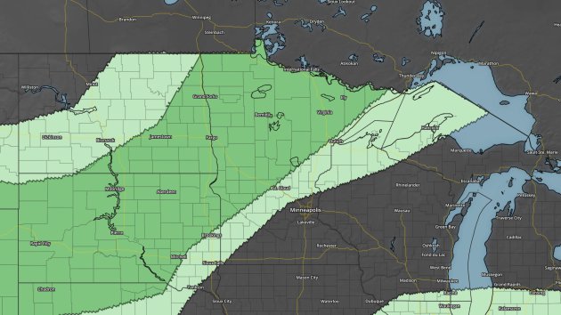
A
few of those storms late in the day Monday, however, could be strong to
severe across parts of northern Minnesota with large hail and damaging
winds the main threats with an incoming front. A Marginal Risk (dark
green) of severe weather is in place.
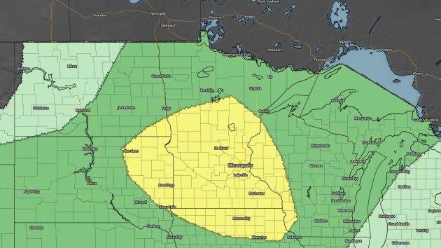
Moving
ahead to Tuesday, we are under a Slight Risk of severe weather (yellow)
across much of central and southern Minnesota as that front continue to
move south. These storms would also be capable of large hail and
damaging winds.
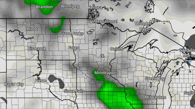
GFS rainfall forecast through Wednesday morning. Green = 1"+. Image: AerisWeather.
Heavy
rain will also be a concern with that front moving through. Analog
guidance is showing a higher potential of seeing at least one inch of
rain across much of southern Minnesota during the day Tuesday, and that
may lead to a flash flood threat across parts of the region.
GFS rainfall forecast through Saturday morning. Green = 1"+, yellow = 2"+, orange = 3"+, red = 4"+. Image: AerisWeather.
As
we head through the rest of the week, that front will linger across the
region, which could lead to more heavy rain and severe weather. We'll
have to watch to see where the front ends up situating over the next few
days to determine who/what time frame has the largest threat. This GFS
model guidance above shows the potential of 2"+ of rain over parts of
the Twin Cities through Saturday morning, with the potential of 3-4"+
across parts of southern Minnesota.
With
that front sagging south of the region this week, temperatures will
hover around to just above average for this time of year, which is
around 83. The models don't really show the next shot at 90 until the
second full week of July at the moment.
________________________________________________
National Forecast Outlook And Stories
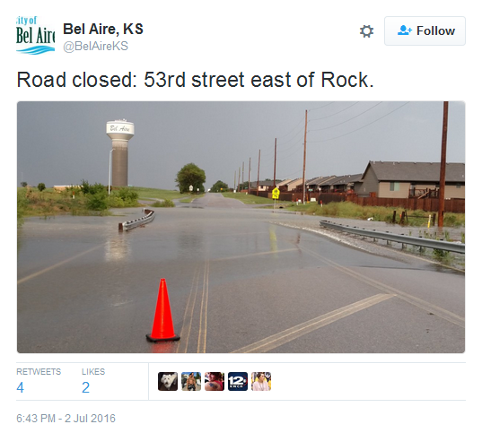
The
main story across the nation right now is the heavy rain falling across
parts of the central United States. This was a picture of flooding in
Bel Aire, KS on Saturday. Numerous flash flood warnings have been in
effect throughout the weekend due to rainfall totals of 3-6"+ in a
relatively short amount of time.
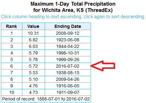
A
total of 5.72" of rain fell Saturday in Wichita, KS, making it not only
the wettest July day on record, but also the sixth overall wettest day
on record for the city.
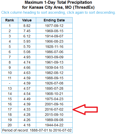
Meanwhile,
Kansas City saw 4.33" of rain on Saturday, marking the 17th wettest day
overall on record and their 4th wettest July day on record.
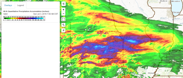
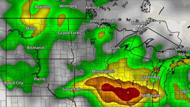
Here's
a look at 48 hour rainfall ending at 7 AM Sunday across the Central
Plains. Radar estimates show many areas receiving over 3" of rain across
parts of Kansas, Missouri, Illinois and Oklahoma, with some topping
10".
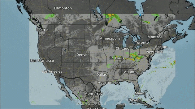
NAM forecast clouds and precipitation every three hours between 7 am Monday and 7 am Tuesday.
For
the Fourth of July, the heaviest rain will move off into parts of the
Mid-Atlantic states, where some flooding could be possible. We will also
see the potential of some storms in parts of the Rockies, Southeast and
toward the panhandles of Oklahoma and Texas.
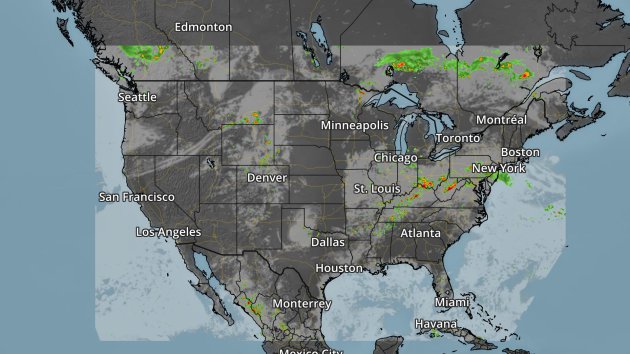
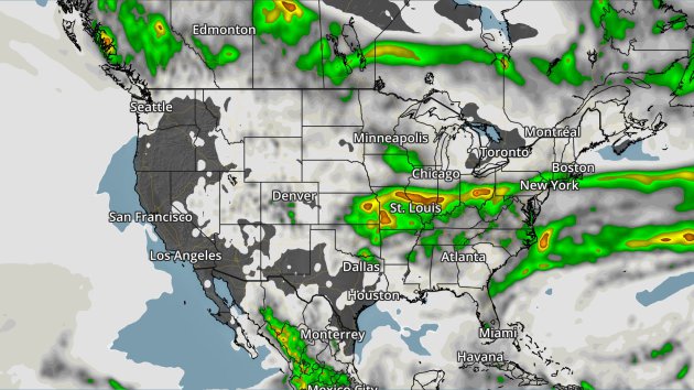
Here's
a look at 10 PM CT Monday Night, showing that some firework displays
during the evening hours across the Ohio Valley and Mid-Atlantic -
potentially up to New York City - could see some rain.
GFS rainfall forecast from Sunday through Wednesday morning. Green = 1"+, yellow = 2"+, orange = 3"+. Image: AerisWeather.
You
can see from Sunday through Wednesday morning the heaviest of the rain
across the nation will fall from Kansas into parts of the Mid-Atlantic
and Northeast, with 1-3"+ amounts possible.
________________________________________________
Thanks for checking in and have a great Fourth of July! Don't forget you can follow me on Twitter (@dkayserwx) or on Facebook (Meteorologist D.J. Kayser)!-D.J. Kayser

No comments:
Post a Comment