Past July Weather
We are
now halfway through the year - can you believe that? Which *typically*
means it's time for the heat to settle in across the region, unlike the
lows in the 30s parts of northern Minnesota saw Friday morning. I
thought I would take a look at where our typical records are for the
seventh month of the year - and while it can be warm, it can also be
quite cool this time of year across the region.
First,
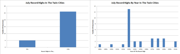
we'll take a look at record highs. Did you know that only five days
during the month of July have never hit 100 over the 100+ years of data
there is for the Twin Cities? The "coolest" record highs of the month
are on the following days: 2nd (99), 9th (99), 17th (99), 25th (99), and
the 29th (98). The warmest record of the month - and the warmest day
ever recorded in the Twin Cities - was back on July 14th, 1936, when the
mercury hit 108. This was during the stretch of Minnesota's worst heat
wave, something we'll talk about more in a minute. Only two of the
current record highs for the month of July have occurred since 2000 -
both in 2012 - on the 2nd (99) and the 4th (101).
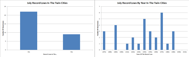
On
the cooler side of things, 22 of the current monthly lows are in the
40s - the coolest morning being July 4th of 1972, when the low was 43.
None of the current record lows on record were set in the 21st century.
The most recent July record low was set back on the 10th of 1996, when
the thermometer dropped to 49 in the Twin Cities.
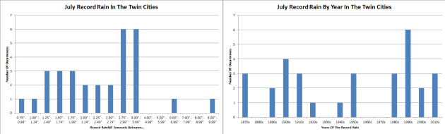
While
July holds the warmest day in Twin Cities history, it also holds the
wettest day. This year will mark the 29th anniversary of the Twin Cities
Superstorm, in which 9.15" of rain fell on July 23rd, 1987, causing
major flooding across the Twin Cities. Meanwhile, the easiest record to
break is at the end of the month, when 0.79" of rain fell on the 31st of
1911.
_______________________________________________
80th Anniversary of the 1936 Heat Wave
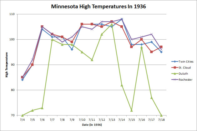
This
week marks the 80th anniversary of the worst heat wave in Minnesota
history back in 1936, when highs for a good majority of 1-2 weeks were
in the 100s across the region. Many of these records still are in place
today, and this heat wave brought the warmest high ever record in the
Twin Cities - 108 degrees on July 14th. Not only was the warmest
temperature on record at the Twin Cities recorded during this stretch,
but at St. Cloud (107 on the 13th which is also tied with two days from
1934), Duluth (106 on the 13th), and Rochester (108 on the 14th) as
well. The warmest Minnesota temperature on record was also tied in this
heat wave, when it reached 114 on July 6th, 1936 in Moorhead.
Here's a recap of the heat wave from Mark Seeley's WeatherTalk blog: "It
started in southern counties on July 4, 1936 with many observers
reporting daytime temperatures over 100F. The Heat Wave spread north
over the next 12-15 days. Even northern communities reported
temperatures close to 100F, and nighttime temperatures remained in the
80s F in many areas, falling into the 70s F near lakes and in low lying
areas. There was no respite from the heat, as many citizens chose to
sleep outside. It is estimated that this Heat Wave caused over 900
deaths in Minnesota and at least 5000 deaths across the nation. It was
also combined with serious drought."
_______________________________________________
Enhanced Severe Risk - No Such Thing as "Safe Sun"
By Paul Douglas
There were more clouds around yesterday than predicted, otherwise holiday weekend weather was better than most years. Less humidity, fewer raging thunderstorms and washed-out picnics; less running and screaming.
Yesterday's persistent cloud cover got me thinking about 'safe sunshine', which is probably an oxymoron. Unprotected exposure to sun results in aging, sagging and wrinkling of skin. The sun is linked to 2 out of 3 cases of melanoma (skin cancer) in the USA. Over 76,000 new cases of invasive melanoma were diagnosed in 2012; over 9,000 resulting in death, according to the American Cancer Society. Everything in moderation, including sunshine.
Dew points surge into the 70s today. Toss in a high near 90F and it feels like 100F later today with an enhanced risk of severe T-storms. Keep an eye out for angry skies later today.
Skies clear Wednesday before the next round of T-storms Thursday. A drop in humidity Friday sets the stage for another fine weekend with highs near 80F under a partly sunny, pleasant sky.
It would appear we've all won the Weather Lotto this summer.
_______________________________________________
Extended Forecast for Minneapolis
WEDNESDAY: More sunshine, a dry sky. High 85. Low 68. Chance of precipitation 10%. Wind NE 5-10 mph.
THURSDAY: Another round of showers, T-storms. High 83. Low 65. Chance of precipitation 60%. Wind SE 10-20 mph.
FRIDAY: Partly sunny, turning less humid. High 80. Low 62. Chance of precipitation 20%. Wind NW 8-13 mph.
SATURDAY: Plenty of sunshine, quite comfortable. High 80. Low 61. Chance of precipitation 10%. Wind E 5-10 mph.
SUNDAY: Windier and a bit warmer. High 83. Low 67. Chance of precipitation 20%. Wind SE 10-15 mph.
MONDAY: Sticky, swarm of T-storms late? High 89. Low 70. Chance of precipitation 50%. Wind S 10-20 mph.
_______________________________________________
This Day in Weather History
July 5th
Tuesday And Beyond Minnesota Weather Outlook
This Day in Weather History
July 5th
1999: Flooding occurs over the Arrowhead. The largest 24-hour rainfall total is 8.84 inches in central St. Louis County.
_______________________________________________
Average Temperatures & Precipitation for Minneapolis
July 5th
Average High: 83F (Record: 100F set in 1982)
Average Low: 64F (Record: 45F set in 1972)
Average Precipitation: 0.13" (Record: 1.62" set in 1994)
________________________________________________
Sunrise/Sunset Times for Minneapolis
July 5th
Sunrise: 5:33 AM
Sunset: 9:02 PM
*Length Of Day: 15 hours, 28 minutes and 51 seconds
*Daylight Lost Since Yesterday: ~1 mins & 2 secs
*Next Sunrise That Is Before 6 AM: August 3rd (6:01 AM)
*Next Sunset That Is Before 9 PM: July 11th (8:59 PM)
________________________________________________
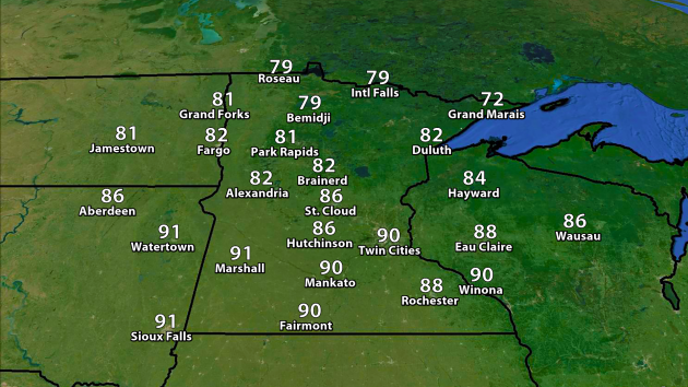
We
have had five days so far this summer with a 90 degree high in the Twin
Cities - could we make it six Tuesday? Highs will soar into the upper
80s and low 90s across southern Minnesota Tuesday, with the Twin Cities
potentially seeing enough warmth to make it to 90. With dewpoints
climbing to near 70, it'll feel more like the mid to upper 90s at times.
Meanwhile, temperatures will be cooler in parts of northern Minnesota,
with places such as Bemidji and International Falls likely not making it
out of the 70s.
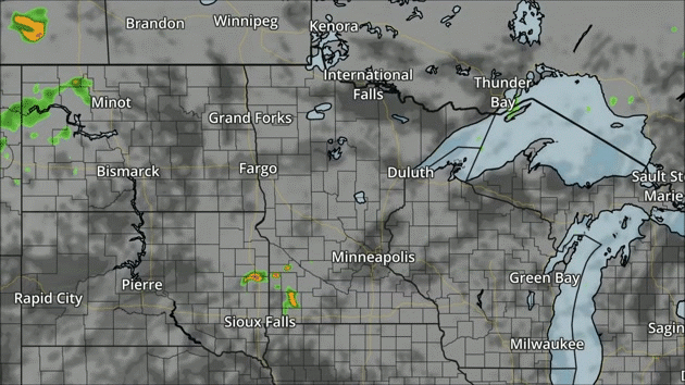
NAM forecast precipitation and clouds every three hours between 7 AM Tuesday and 7 AM Wednesday.
We'll
be watching a cold front drag south across the region Tuesday, with
storms popping in the afternoon hours across central and southern
Minnesota. These storms could be strong to severe and bring heavy
rainfall with them.
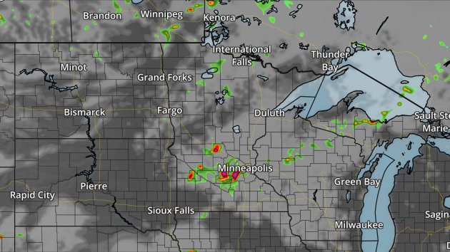
This is a snapshot of the NAM at 7 PM Tuesday, showing storms moving into the metro area.
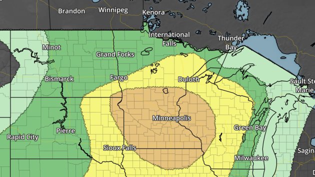
Severe risk Tuesday. Dark green - marginal threat. Yellow - slight threat. Orange - enhanced threat.
There
is an Enhanced Threat of severe weather across central and southern
Minnesota Tuesday, including places like the Twin Cities, St. Cloud,
Mankato and Rochester. We'll be watching for the potential of all modes
of severe weather, including large hail, damaging winds, and (especially
early on in storm formation during the afternoon) isolated tornadoes.
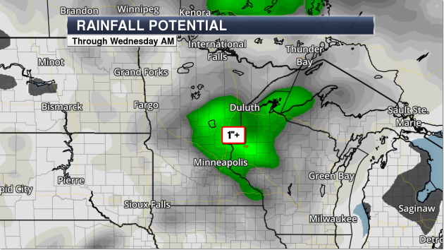
GFS rainfall forecast through Wednesday morning. Green = 1"+. Image: AerisWeather.
Atmospheric
water levels will be high tomorrow with this system (precipitable water
values will approach 2") which will mean we will watch the potential
for very heavy rain. The GFS model (shown above) shows the potential for
at least an inch of rain to fall through Wednesday morning across parts
of eastern and southern Minnesota.
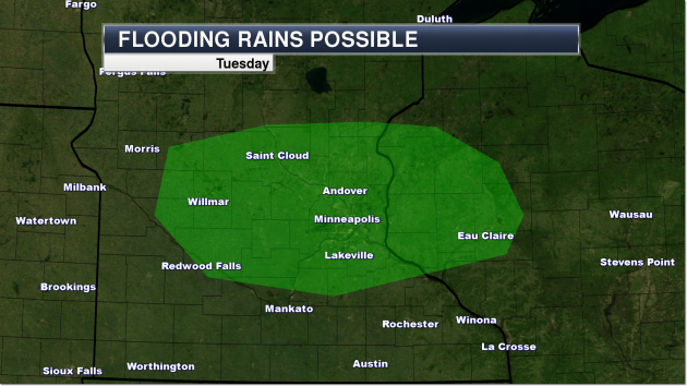
The
Weather Prediction Center has highlighted an area across central
Minnesota (including the Twin Cities) Tuesday where rainfall amounts
could exceed flash flood guidance with the incoming storms.
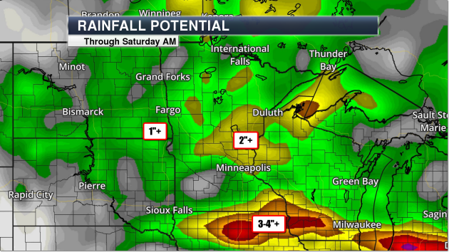
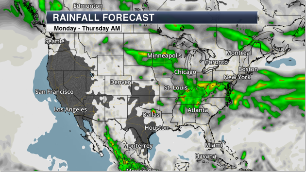
GFS rainfall forecast through Saturday morning. Green = 1"+, yellow = 2"+, orange = 3"+, red = 4"+. Image: AerisWeather.
While
we will see the rain move out of the area (for the most part) by
Wednesday, we will watch another round move in for Thursday and Friday
which could be another severe weather and heavy rain producer across the
region. As we get closer we'll be able to pin down timing and location a
bit more.

Temperatures
will hover around average for much of the next seven days in the Twin
Cities. Models continue to hint at a possible warm up heading into late
next week, with 90s possible once again.
________________________________________________
National Forecast Outlook And Stories
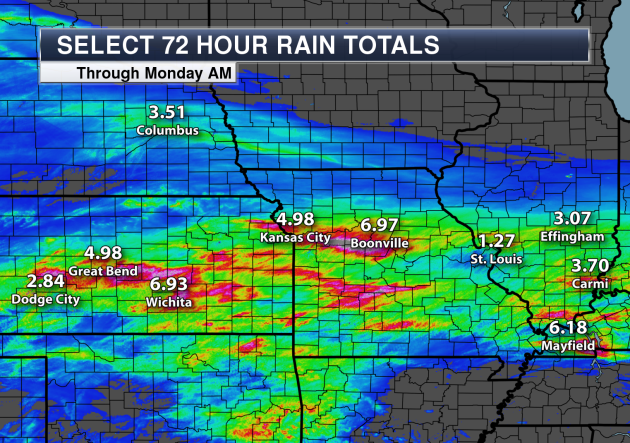
Heavy
rain has been the main story over the past few days across the Central
Plains. Check out some of these select 72-hour rainfall totals through 7
AM Monday morning - some areas receiving over a half a foot of rain
within a short amount of time. Columbia, MO saw 3.58" of rain Sunday,
not only shattering the old record of 3.14" set in 1984 but also placing
as the fourth wettest July day on record.
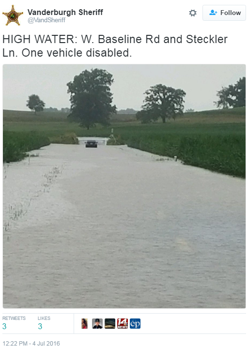
Flooding In Southern Indiana Monday Morning (photo: @VandSheriff on Twitter):
NAM forecast precipitation and clouds every three hours between 7 AM Tuesday and 7 AM Wednesday.
Storms
will be possible across the Northern Plains Tuesday as a cold front
moves through, with storms potentially reaching the Chicago area by
Wednesday morning. Elsewhere, some showers are possible in the
Northeast, especially in the morning hours, meanwhile scattered showers
and storms will be possible throughout the day in the Mid-Atlantic and
Southeast.
GFS rainfall forecast through Thursday morning. Green = 1"+, yellow = 2"+, orange = 3"+. Image: AerisWeather.
The
heaviest of rain from Monday through Thursday morning will be across
parts of the northern Plains with that incoming cold front and in parts
of the Mid-Atlantic and Southeast, where rain totals could top 2" in
spots.
Political Convention Weather
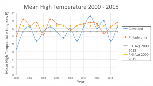
The
Republican and Democratic conventions are coming up later this month in
Cleveland and Philadelphia (respectively), and cleveland.com asks the
most important question of the political season: who typically sees better weather? Here is a snippet from their section on temperatures: "If
you like hot temperatures, then visiting the DNC in Philadelphia is for
you. If you like to stay on the cooler side, then stick to the RNC in
the CLE. Philadelphia averages about 4 degrees hotter than Cleveland."
Seven Climate Record Already In 2016
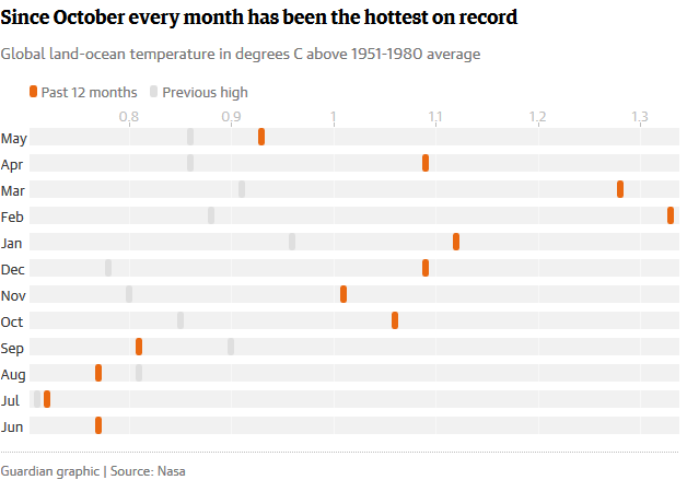
Numerous climate records have already been broken around the world so far this year. The Guardian put together a list of seven climate records already smashed in 2016: "From
soaring temperatures in Alaska and India to Arctic sea ice melting and
CO2 concentrations rising, this year is smashing records around the
world."
________________________________________________
Thanks for checking in and have a great Tuesday! Don't forget you can follow me on Twitter (@dkayserwx) or on Facebook (Meteorologist D.J. Kayser)!-D.J. Kayser

No comments:
Post a Comment