79 F. average high on August 21.
78 F. high on August 21, 2015.
August 22, 1910: Daylight is dimmed in Duluth due to smoke from Rocky Mountain forest fires.
August 22, 1870: Downpours across southern Minnesota produce 5 inches at Sibley, and 3.49 at Ft. Snelling. Much of the wheat crop is damaged.

Another Atmospheric Gift - Storms by Midweek
"God's gifts put man's best dreams to shame" wrote Elizabeth Barrett Browning. At the end of Sunday's Marathon in Rio USA bronze medal winner Galen Rupp said "there's always another chapter".
We all have gifts; every individual is one-of-a-kind. Unique. Precious.
My father just turned 86. He was a salesman, a printer - but he was born with a photographic memory and a gift for story-telling. He has thousands of stories from his youth; he remembers conversations, colors, even favorite desserts from 75 years ago! Growing up he would leave clippings of weather stories by my cereal bowl every morning. Now he sends links to stories on the web.
May we never lose our appreciation for a good story.
After free weekend A/C - 80s return the next couple of days; models hinting at another inch of rain midweek, before a cleansing breath of Canadian air by late week.
The lake out back is higher than I've ever seen it in late August. No sign of brown lawns or drought creeping back anytime soon. Quite the contrary: it was a hot and soggy summer - like having 3 sloppy Junes in a row this year.
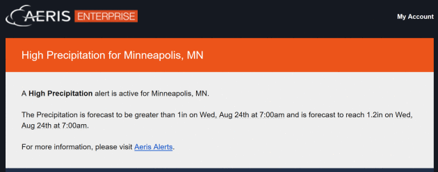
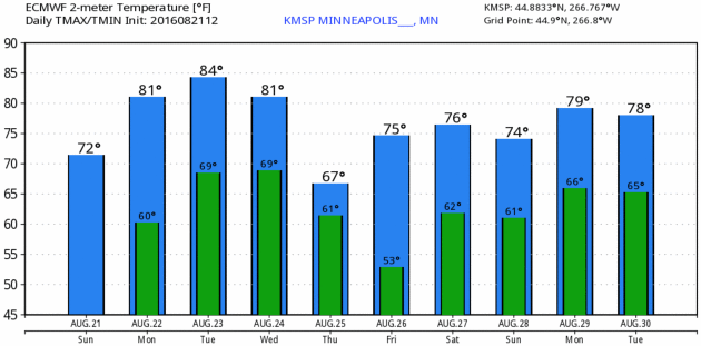
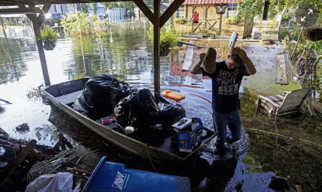
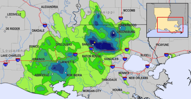
Photo credit: "Daniel Stover, 17, wipes his head as he helps rescue people’s belongings in Sorrento, Louisiana, on Saturday." Photograph: Max Becherer/AP.
Louisiana Ignored Dire Forecasts and Flash Flood Warnings. The fact that this epic storm didn't have a name, it wasn't a tropical storm or hurricane, helped to downplay overall consumer awareness of what was coming. Here's an excerpt of an interview at NPR:
SHEPHERD: People have a hard time grasping things that they haven't experienced.
KAILATH: According to the research Shepherd cites, people around the world are going to see more and more weather for which they have no reference point.
SHEPHERD: People just assume a heavy rainstorm is a heavy rainstorm, just like the storms they experienced growing up as a child or perhaps 10 years ago.
KAILATH: But in fact, Shepherd says, today's storms are different - more destructive and only getting stronger. Inland communities like Baton Rouge haven't experienced floods like this before, but increasingly, they'll have to learn to prepare for them anyway. Ultimately, Shepherd says, the responsibility for getting ahead of a disaster is personal..." (File photo: NOAA).
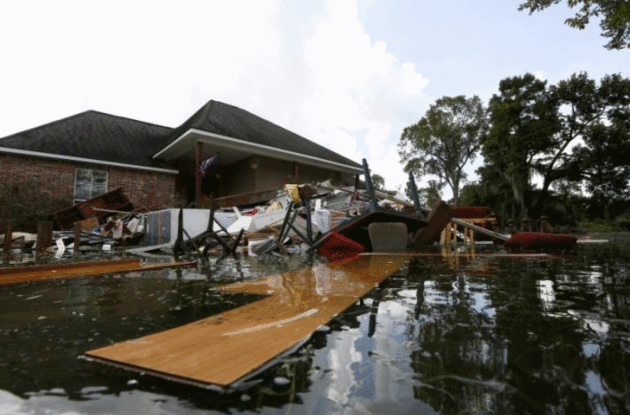
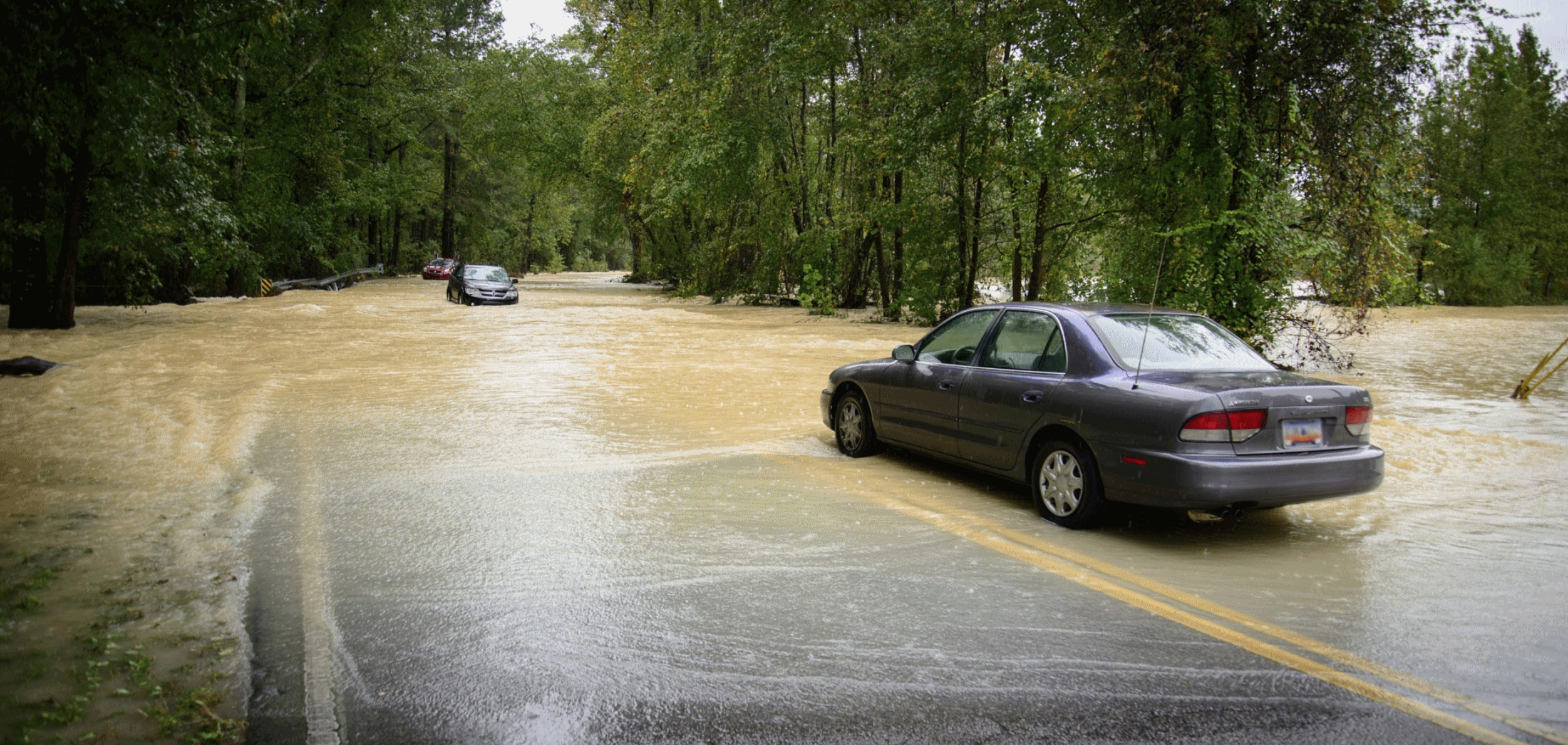
Photo credit: "Debris is seen floating in flood water in front of a damaged home in St. Amant, Louisiana, U.S., August 21, 2016." REUTERS/Jonathan Bachman.
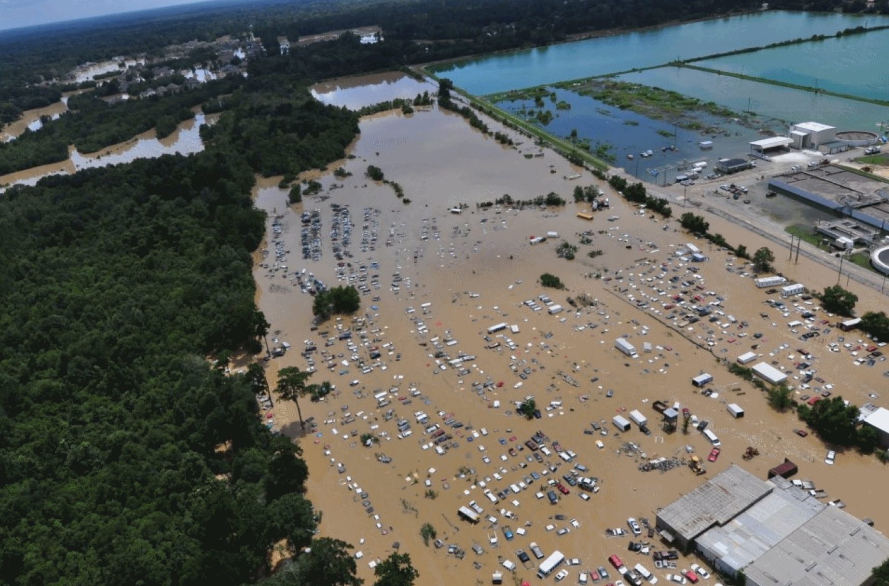
110,000 Homes Worth a Combined $21 Billion Are In Louisiana's Flood-Affected Zones, Study Says. The Washington Post reports: "The first attempt to assess the scope of damage from the past week’s historic flooding in Louisiana has produced staggering numbers. Approximately 280,000 people live in the areas that flooded, according to an analysis released Friday by the Baton Rouge Area Chamber. In those flood-affected areas are 110,000 homes worth a combined $20.7 billion and more than 7,000 businesses — about one in every five businesses in the region — that together employ more than 73,000 people. The figures underscore two of the biggest challenges that families as well as local, state and federal officials face as they work to recover from the unprecedented flooding: How to house those left suddenly homeless, and how to pay for the recovery..."
Photo credit: "In this Aug. 15, 2016, U.S. Coast Guard handout photo, flooded areas of Baton Rouge are seen from the air."
"They Didn't Warn You": Louisiana Disaster Reveals Deep Challenges in Flood Communication.
There was no formal tropical storm or hurricane to track or warn on.
Did the stalled tropical depression get the media time and attention it
deserved? Here's an excerpt from Jason Samenow at Capital Weather Gang: "...Some
Louisiana residents said they were completely caught off guard by the
severity of this extreme event. “With a hurricane, they kind of warn
you. But this, they didn’t warn you,” Jayda Guidry, a resident forced
from her home, told The Washington Post.
“We just thought it was raining.” Meteorologists knew this storm could
wreak havoc days before the first drops of rain. And they issued
strongly worded predictions. But now they are soul-searching, wondering
how the message could’ve been more forcefully conveyed and attained
greater reach..."
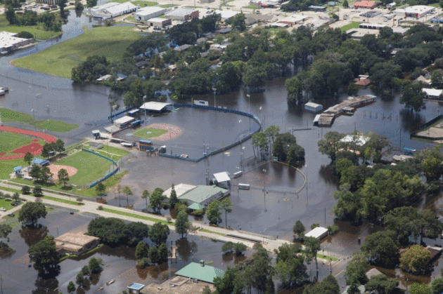
Photo credit: "A flooded baseball field at the Gonzales Civic Center in Gonzales, La., on Aug. 17." (Jeffrey Dubinsky via Reuters).
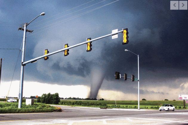
Scientists Explore Future of Storm Prediction.
The University of Oklahoma has an interesting look at how social media
and drones are impacting tornado detection, prediction and
communications; here's an excerpt at normantranscript.com: "The
panel trumpeted the impact of social media and pointed to a potential
shift in the way people stay ahead of the storm. The Weather Channel’s
Mike Bettes said people still flock to their TVs for up-to-date storm
information but said more people are looking to social media outlets for
vital updates. “If you look at something like Twitter now, you can do
live video,” Bettes said. “Facebook is a way for families to reconnect
after [the storm]. I think it’s just evolving now. I think this is
probably bad to say, because I’m a TV broadcaster, but I think TV is
becoming a bit of a dinosaur...”
Photo credit: Nick Rutledge for The Transcript.
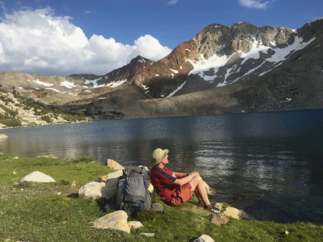
Photo credit: "Nicholas Kristof enjoying part of his inheritance (as an American citizen), a lake on the John Muir Trail in California." Credit Caroline Kristof.

What Does a Dog Want More - "Good Boy" or Treats? Here's a clip from The Washington Post: "...New research shows that my effort may be overkill. According to the study, published online in the journal Social, Cognitive and Affective Neuroscience, more dogs prefer praise over food. The finding by Emory University neuroscientist Gregory Berns followed a novel method of investigation: He used an MRI to scan a dog’s brain while the dog was awake and unrestrained..."
TODAY: Warm sunshine, windy. Winds: S 15-30. High: 84
MONDAY NIGHT: Clear and mild. Low: 68
TUESDAY: Sunny, minor whining about humidity. Winds: S 15-25. High: 86
WEDNESDAY: Showers and T-storms taper. Winds: W 10-15. Wake-up: 69. High: 82
THURSDAY: Partly sunny, cooler breeze. Winds: NW 10-20. Wake-up: 58. High: 72
FRIDAY: More sunshine, probably pleasant. Winds: SW 8-13. Wake-up: 57. High: 79
SATURDAY: Some sun, isolated T-storm risk. Winds: S 10-15. Wake-up: 61. High: 82
Climate Stories...

Photo credit: "Peter Wadhams in the Arctic in 2007: ‘We may able to raise the Thames barrier in Britain but in Bangladesh, people will be drowned."
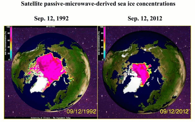
Historical Data Shows Arctic Melt of Last Two Decades is "Unprecedented". Here's an excerpt from InsideClimate News: "...Now, scientists have compiled the most detailed study to date
of sea ice records going back more than a century and a half. The data
shows that the rapid meltdown that satellites have been documenting
since 1979 is unprecedented since at least 1850 and coincides with the
buildup of heat-trapping greenhouse gases in the atmosphere from burning
fossil fuels. Arctic sea ice has not been at levels as low as today's for at least 5,000 to 7,000 years, according to Julienne Stroeve, a researcher with the National Snow and Ice Data Center (NSIDC), who was not involved in the study.
"It may have been sometime during the mid-Holocene, based on driftwood
found in Greenland that came from Siberia," she said. "Some other
studies have suggested at least 800,000 years..."
Image credit: "A gridded database of Arctic sea ice extending back to the 1800s."
No comments:
Post a Comment