79 F. average high on August 20.
73 F. high on August 20, 2015.
.22" rain fell at St. Cloud yesterday.
4.17" rain so far in August.
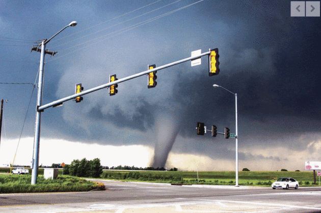
August 21, 1918: Minnesota's third deadliest tornado strikes Tyler and destroys the downtown area, leaving 36 dead.
August 21, 1886: High winds hit Northfield with winds blowing at 60 mph for 20 minutes. Peak gusts up to 75-80 mph are recorded.
August 21, 1883: The 4th deadliest tornado in Minnesota history hits Rochester. The tornado kills 31 residents and injures 100 more. Appalled by the lack of medical care received by the tornado's victims, Mother Alfred Moes, founder of the Sisters of St. Francis, proposes to build and staff a hospital if Dr. W.W. Mayo will provide medical care. St. Marys Hospital opens in 1889 with 27 beds and eventually grows into the Mayo Clinic.

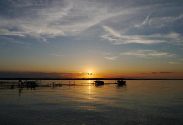
A Touch of October Today, But 80s Return Monday
Nobody will be complaining about the heat index today. Sunscreen is optional. Your favorite lake is warmer than the air temperature. And a flurry of light jackets this morning give way to shorts by afternoon.
The sun is as high in the sky as it was on April 21. Longer nights are brewing up progressively colder airmasses over Canada. One such cheap shot of chilly air spun up Saturday's comma-shaped swirl of rain over Minnesota, with temperatures stunted in the 60s. Perfectly average for early October.
Note to self: summers are expanding, with a longer growing season. Two more months of boating; 70s well into October. It would be premature to write an obituary for the Summer of '16.
Sunshine returns today; 40s and 50s early giving way to low 70s by late afternoon. Expect 80s Monday and Tuesday with midweek showers giving way to another push of cooler air by late week. No cold fronts, no torrential rains and storms with names. NOAA's GFS model is hinting at a hurricane near New England by early September.
I'm skeptical - but remind me not to complain about a few cool fronts.
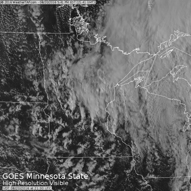
A Volatile Atmosphere.
I saved a loop of the visible satellite animation Saturday evening,
showing the showers and T-storms that sprouted in response to severe
instability. The result: a mix of sunshine and tropical downpours with
temperatures in the 60s. The definition of a fickle sky.
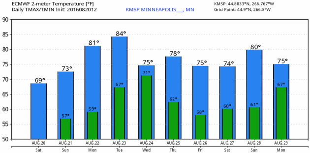
Warming Trend into Tuesday.
No more stinking hot weather is brewing, looking out 2 weeks or so.
Cool fronts will become more frequent and formidable as we sail into
September. Nothing controversial about that. With any luck it'll dry out
a little to help with fall harvest. MSP Meteogram: WeatherBell.
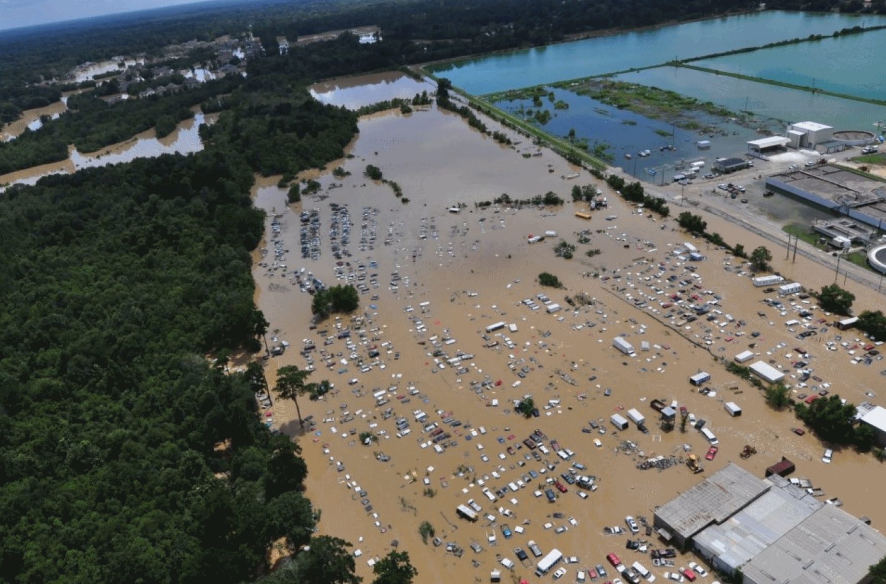
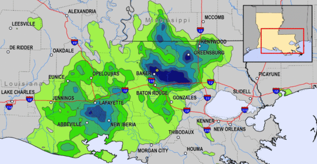
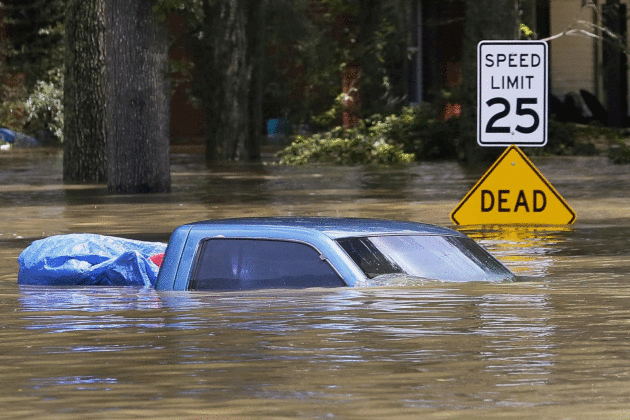
110,000 Homes Worth a Combined $21 Billion Are In Louisiana's Flood-Affected Zones, Study Says. The Washington Post reports: "The first attempt to assess the scope of damage from the past week’s historic flooding in Louisiana has produced staggering numbers. Approximately 280,000 people live in the areas that flooded, according to an analysis released Friday by the Baton Rouge Area Chamber. In those flood-affected areas are 110,000 homes worth a combined $20.7 billion and more than 7,000 businesses — about one in every five businesses in the region — that together employ more than 73,000 people. The figures underscore two of the biggest challenges that families as well as local, state and federal officials face as they work to recover from the unprecedented flooding: How to house those left suddenly homeless, and how to pay for the recovery..."
Photo credit: "In this Aug. 15, 2016, U.S. Coast Guard handout photo, flooded areas of Baton Rouge are seen from the air."
"They Didn't Warn You": Louisiana Disaster Reveals Deep Challenges in Flood Communication.
There was no formal tropical storm or hurricane to track or warn on.
Did the stalled tropical depression get the media time and attention it
deserved? Here's an excerpt from Jason Samenow at Capital Weather Gang: "...Some
Louisiana residents said they were completely caught off guard by the
severity of this extreme event. “With a hurricane, they kind of warn
you. But this, they didn’t warn you,” Jayda Guidry, a resident forced
from her home, told The Washington Post.
“We just thought it was raining.” Meteorologists knew this storm could
wreak havoc days before the first drops of rain. And they issued
strongly worded predictions. But now they are soul-searching, wondering
how the message could’ve been more forcefully conveyed and attained
greater reach..."
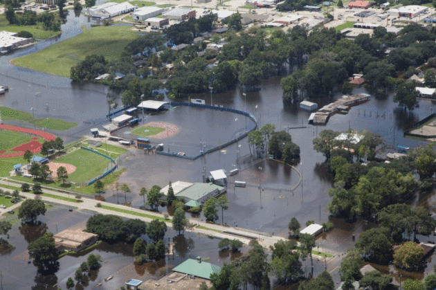
Photo credit: "A flooded baseball field at the Gonzales Civic Center in Gonzales, La., on Aug. 17." (Jeffrey Dubinsky via Reuters).

How Louisiana Plans to Rebuild After Historically Damaging Floods. Here's an excerpt of an interview at PBS NewsHour: "...Well,
FEMA will give up to $33,000 if you weren’t in a flood zone and had no
insurance, but the average — that’s the maximum you can get. The average
is about $7,500. We’re going to have to make up that difference with
volunteers and the giving of people from all over the country working
with nonprofits to help make those people back in their house and make
them whole. A lot of elderly people that had never flooded, lived in a
house 40 or 50 years, didn’t see the need or couldn’t afford the flood
insurance. So, those are — those are the ones that we’re really
concerned about...."
Scientists Explore Future of Storm Prediction.
The University of Oklahoma has an interesting look at how social media
and drones are impacting tornado detection, prediction and
communications; here's an excerpt at normantranscript.com: "The
panel trumpeted the impact of social media and pointed to a potential
shift in the way people stay ahead of the storm. The Weather Channel’s
Mike Bettes said people still flock to their TVs for up-to-date storm
information but said more people are looking to social media outlets for
vital updates. “If you look at something like Twitter now, you can do
live video,” Bettes said. “Facebook is a way for families to reconnect
after [the storm]. I think it’s just evolving now. I think this is
probably bad to say, because I’m a TV broadcaster, but I think TV is
becoming a bit of a dinosaur...”
Photo credit: Nick Rutledge for The Transcript.
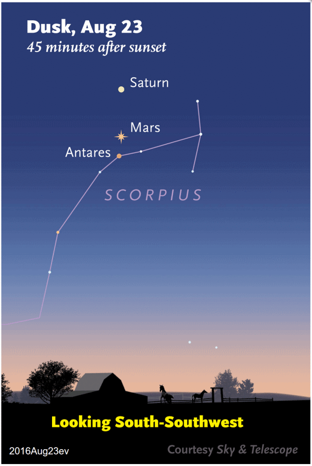
Image credit: "Saturn, Mars, and Antares line up almost vertically on the evening of August 23 and 24, 2016. Have a look!" Credit: Sky & Telescope diagram.

Bigger, Better, Cheaper: Wind Power is Flourishing in the U.S. Dave Roberts reports for Vox; here's the intro: "Here’s some good news for your weekend: Wind power is kicking ass in the US. That is the TL;DR version of the annual Wind Technologies Market Report
just released by the US Department of Energy and Lawrence Berkeley
National Laboratory (LBNL). With 73,992 MW, the US is now the No. 2
country in the world in installed wind capacity (after China, which has a
mind-boggling 145,053 MW).
And we are No. 1 in actual wind electricity generated. All that wind
only provides about 5.6 percent of US electricity, though, which puts us
well behind leaders like Denmark (40 percent), Portugal, Ireland, and
Spain (between 20 and 30 percent)..." (File photo: Shutterstock).

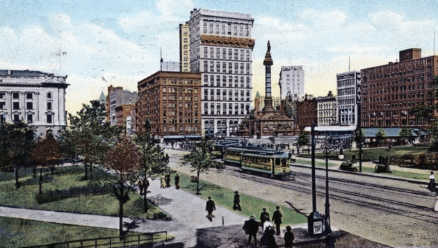
Image credit: "Cleveland's Public Square in the 1910s." (Photo: Public domain)
“If you can't be a good example, then you'll just have to serve as a horrible warning.” – Catherine Aird
TODAY: Cool sun, a much better day. Winds: NW 8-13. High: 73
SUNDAY NIGHT: Clear and comfortable. Low: 59
MONDAY: Partly sunny with a warm wind. Winds: S 15-30. High: 84
TUESDAY: Sticky sun, feels like summer again. Winds: S 10-20. Wake-up: 68. High: 89
WEDNESDAY: Showers and T-storms likely. Winds: NW 7-12. Wake-up: 67. High: 81
THURSDAY: Intervals of sun, cooler breeze. Winds: NW 10-15. Wake-up: 60. High: 76
FRIDAY: Plenty of lukewarm sunshine. Winds: NW 8-13. Wake-up: 58. High: 77
SATURDAY: Chance of showers, few T-storms. Winds: SE 8-13. Wake-up: 60. High: 76
Climate Stories...
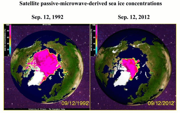
Historical Data Shows Arctic Melt of Last Two Decades is "Unprecedented". Here's an excerpt from InsideClimate News: "...Now, scientists have compiled the most detailed study to date
of sea ice records going back more than a century and a half. The data
shows that the rapid meltdown that satellites have been documenting
since 1979 is unprecedented since at least 1850 and coincides with the
buildup of heat-trapping greenhouse gases in the atmosphere from burning
fossil fuels. Arctic sea ice has not been at levels as low as today's for at least 5,000 to 7,000 years, according to Julienne Stroeve, a researcher with the National Snow and Ice Data Center (NSIDC), who was not involved in the study.
"It may have been sometime during the mid-Holocene, based on driftwood
found in Greenland that came from Siberia," she said. "Some other
studies have suggested at least 800,000 years..."
Image credit: "A gridded database of Arctic sea ice extending back to the 1800s."

Enlist the Market in the Climate-Change Fight. Here's the intro to an Op-Ed at The Wall Street Journal: "Even before the devastating flooding began in Louisiana last week, and we learned that July 2016
shattered all global temperature records, mounting data had
demonstrated the growing risks climate change poses to the global
economy. Whether you are an investor assessing the $2 trillion in bonds
that Moody’s
found carry elevated near-term climate risk, one of the nearly two
million U.S. homeowners facing significant risk from climate-related
flooding, or a U.S. taxpayer staring at $360 billion in direct
government costs from extreme weather over the past decade—these threats
are looming, large and increasing. This year’s World Economic Forum Global Risks Report declared the “failure of climate-change mitigation and adaptation” the “risk with the greatest potential impact in 2016...”
Climate Change Will Redraw Louisiana's Flood Risk Maps. Here's an excerpt from Newsweek: "...And
FEMA is going with another, more direct way of managing the increasing
risks of climate change: encouraging more severe weather-resistant
infrastructure. Some of the funds FEMA provides for a disaster go
towards rebuilding cities and houses to stricter code and in areas that
aren’t quite so risky—say, at higher elevations or further away from the
ocean. “Instead of constantly rebuilding for the next disaster, it’s
much smarter to use federal dollars to build safer and build back,” says
Lemaitre. As climate change risks climb and insurance costs rise to
reflect reality, the shoreline of Louisiana will change, too: fewer
buildings on the coast, and a lot more houses on stilts."
Photo credit: "

Space, Climate Change, and the Real Meaning of Theory. Here's an excerpt of an excellent essay from Piers Sellers at The New Yorker: "...Climate-change deniers in the United States have done a first-class job in spreading confusion and misinformation. As a result, many prominent politicians insist, and get away with insisting, that climate change is a hoax, a mantra that has gained some credibility through sheer repetition. Climate deniers are also fond of saying that global warming is not resolved in science or is “just” a theory. This is a perfect example of Orwellian Newspeak which also flies in the face of three hundred years of scientific progress, in which intellectual argument and conviction must be based on facts and substantiated theories, rather than personal beliefs or biases. It is also dangerous. If nothing is done to reduce carbon emissions over the next couple of decades, our climate models predict that there will be massive changes in the global precipitation and temperature patterns, with huge effects on water and food security, and dramatic sea-level rise..." (Image credit: NASA).
No comments:
Post a Comment