74 F. high temperature in St. Cloud Friday.
81 F. average high on August 12.
85 F. high on August 12, 2015.
.29" rain fell in the Twin Cities yesterday as of 8pm. Only .04" fell at St. Cloud.
August 13, 1964: Minnesota receives a taste of fall, with lows of 26 in Bigfork and 30 in Campbell.
 A Bronze Saturday, but Sunday Gets a Gold Medal
I'm
still waiting for a call back from NBC. My idea is simple but
revolutionary. For every Olympic event pick someone at random, sitting
up in the stands, to compete. Because we need perspective to appreciate
how amazing these super-athletes really are.
The ratings would
double. Think "Rio Olympics" meets "America's Got Talent" meets "Biggest
Loser". I'll keep waiting by the phone.
We react to weather, not
climate. It's in our DNA to respond to daily swings in temperature &
moisture, but long-term trends can be just as interesting. Even though
weekend temperatures cool back down to "normal" the summer of '16 is
running warmer than the 30-year average. Based on cooling degree days
since
June 1 we've spent 26 percent more than average cooling our homes this summer. And that doesn't factor dew point or heat index.
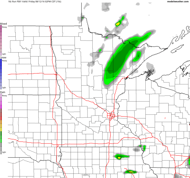
The cold pool aloft responsible for
Friday's
showers is pushing east; a stray instability shower can't be ruled out
this afternoon. Expect warm sunshine with highs near 80F
Sunday, a chance for your yard to dry out after waves of tropical downpours.
More June than August.
Drier Than Friday - But PM Instability Shower Possible.
NOAA's 4km NAM model hints at instability showers and possible
T-showers by mid and late afternoon, especially south and west of the
Twin Cities. Not as widespread or heavy as yesterday, but a renegade
shower can't be ruled out later today. Source: NOAA and AerisWeather.
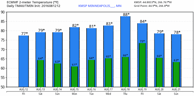
Comfortable Weekend - Warming Up Next Week.
ECMWF (European) model guidance may be a couple degrees too cool today
and Sunday, but there's little doubt we'll warm up to near 90F by next
Thursday. Source: WeatherBell.
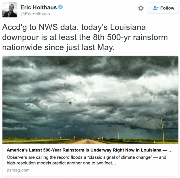
America's Latest 500-Year Rainstorm is Underway Right Now in Louisiana. Meteorologist Eric Holthaus provides perspective at
Pacific Standard; here's an excerpt: "...
An instant analysis
from Climate Nexus refers to today’s Louisiana rainstorm as a “classic
signal of climate change.” It’s right. The NWS maintains a statistical database
used to calculate the “annual exceedance probability” of a given
rainfall event — basically, the expected frequency this event would
occur in any given year. Today’s rainstorm in Louisiana is at least the
eighth 500-year rainfall event across America in little more than a
year, including similarly extreme downpours in Oklahoma last May,
central Texas (twice: last May and last October), South Carolina last
October, northern Louisiana this March, West Virginia in June, and
Maryland last month..."
The Times Picayune in New Orleans has live-blogging on the ongoing flooding disaster across Louisiana and Mississippi at
NOLA.com.
Aeris Weather Briefing: Issued Friday, August 12
th, 2016
- Flash Flood Emergencies
have been issued this morning across portions of Louisiana and
Mississippi after 8-12”+ of rain has fallen in the past 24 hours.
- An
additional 4-9” of rain are possible over the next couple days across
parts of Louisiana, Mississippi and southwest Texas, including New Orleans, Beaumont and Alexandria.
- Heavy rains will also be possible today in the Milwaukee and Chicago areas and through the weekend from Oklahoma into Ohio. Flooding will be possible in both of these regions.
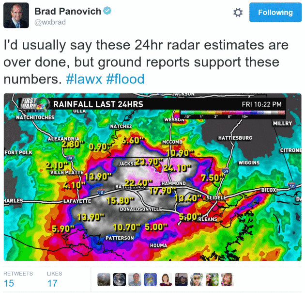
At Least Eight Inches Of Rain. The
heaviest of the rain over the past 24 hours has been across portions of
Louisiana and Mississippi. Over 8” of rain has been reported from
Hammond and Amite (LA) toward Centerville and Osyka (LA). In Central,
LA, 11.10” of rain was reported in the past 24 hours by an observer as
of 6 AM.
Flash Flood Emergencies. Parts
of Louisiana and Mississippi are under Flash Flood Warnings and even
Flash Flood Emergencies due to the heavy rain. Flash Flood Emergencies
are more serious and life-threatening than traditional Flash Flood
Warnings, as they are indicative of widespread flash flooding that will
cause significant/catastrophic impacts to property and life. Numerous
water rescues have been conducted across the region, and some roads are
flooded.
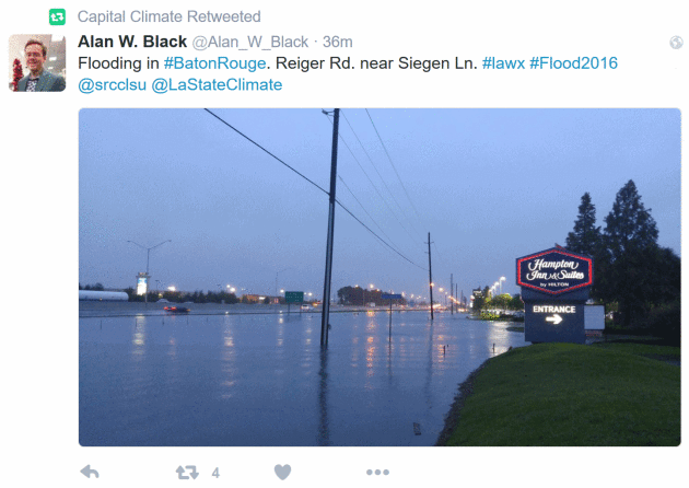
Roads Closed Due To Flooding In Louisiana.
As of earlier this morning, parts of LA 427 in Baton Rouge and I-55 in
the Flunker, LA area were closed due to flooding. For more information:
http://hb.511la.org/#roadReportsHome?layers=roadReports%2Cflooding&timeFrame=TODAY
Additional Rain Through Monday.
Very heavy rain will continue over the next couple days across parts of
Mississippi and Louisiana, with the potential of another 4-9” in spots.
Forecast Rain Through Sunday:
Mobile, AL: 2-4”
New Orleans, LA: 3-6”
Baton Rouge, LA: 5-8”
Lafayette, LA: 5-8”
Beaumont, TX: 3-5”
Shreveport, LA: 2-4”
Alexandria, LA: 3-6”
Flood Watches In Effect.
Flood Watches remain in effect for parts of the Gulf Coast into the
early weekend for the heavy rain expected over the next few days.
Flooding Concerns Today.
The Weather Prediction Center has outlined areas across parts of the
Gulf Coast today where the best opportunity of flash flooding will occur
with heavy rain falling and already saturated ground. The best
probability of heavy rain that could lead to flooding will be across
parts of eastern Louisiana and southern Mississippi, where they have
placed a “High” threat of flooding. The flooding rain potential will
continue through
Saturday across these areas.
Heavy Rain Spreads North.
As the moisture-laden low pressure center finally starts moving north
into late this weekend and early next week, it will meet a slow moving
front. While the front will have enough moisture to produce heavy rain
this weekend (potentially 3-6”), more heavy rain will be expected from
Oklahoma into the Ohio Valley into the middle of next week.
Flood Watches.
Flood Watches have been issued for the weekend from northern Arkansas
to Ohio for the potential of 3-6” of rain this weekend, which could lead
to flooding issues.
Flooding Across The Upper Midwest.
Flash Flood Watches are also in effect for parts of the upper Midwest
for the potential of 2-4” of rain throughout the day today, including in
the
Chicago and Milwaukee areas.
Summary. Water
rescues have occurred over parts of Louisiana and Mississippi this
morning as 6-12”+ of rain has fallen across parts of the region over the
past 24 hours. More heavy rain is possible across the region into the
weekend, with another 4-9”+ possible from
New Orleans to Alexandria and Beaumont. Meanwhile, heavy rain will also be possible today across parts the upper Midwest, including the
Chicago and Milwaukee
areas, and into the weekend from Oklahoma to Ohio. Facilities across
these areas that normally experience problems during flash flood
scenarios should be on alert for issues over the next few days.
D.J. Kayser, Meteorologist, AerisWeather
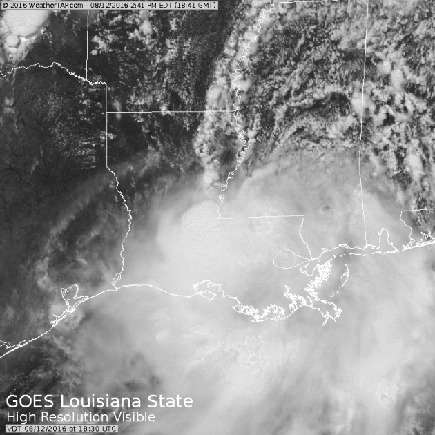
Gulf Storm of August 2016.
Not a named tropical storm or hurricane, but the stalled tropical
disturbance over the Gulf of Mexico has wreaked havoc, especially across
Louisiana and Mississippi. Here's some perspective from
Climate Signals: "
A
slow-moving storm system, fed by unusually warm seas in the Gulf of
Mexico, began on August 7 to unleash heavy rains in the Southeastern
United States. The storm may trigger flash flooding in spots, and parts
of the Gulf Coast could see up to 20 inches of rainfall through August
14. On August 11, a measure of atmospheric moisture, precipitable water,
was in historic territory at 2.78 inches, a measurement higher than
during some past hurricanes in the region. Increased moisture in the air
and unusually heavy rainfall are classic signals of climate change. As
the world warms, storms are able to feed on warmer ocean waters, and the
air is able to hold and dump more water. These trends have led to a
pronounced increase in intense rainfall events and an increase in
flooding risk. In the Southeastern US, extreme precipitation has
increased 27 percent from 1958 to 2012." (Visible loop: WeatherTap).
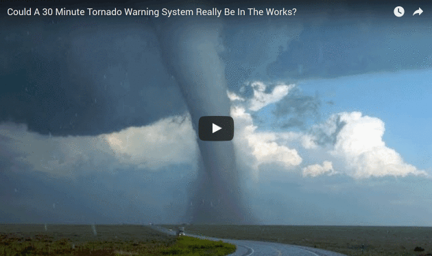
Could a 30-Minute Tornado Warning System Really Be In The Works? Don't hold your breath.
Inside Science reports; here's an excerpt: "...
Angela
looked at data from an instrument called a ring laser. Lamb described
the instrument “a ring laser detects any kind of disruption within
Earth’s normal frequencies.” She also said, “the ring laser is able to
detect infrasound, which is just any kind of wave that is below 20 hertz
which is below anything that we can hear. But can be caused by
tornadoes coming through, that’s actually what we’ve been finding.” The
hours she spent combing through data paid off because the ring laser
data revealed something new. “Something that we found last summer, is
that we were getting these frequency peaks not only while a tornado was
on the ground, but 30 minutes before,” replied Lamb..."
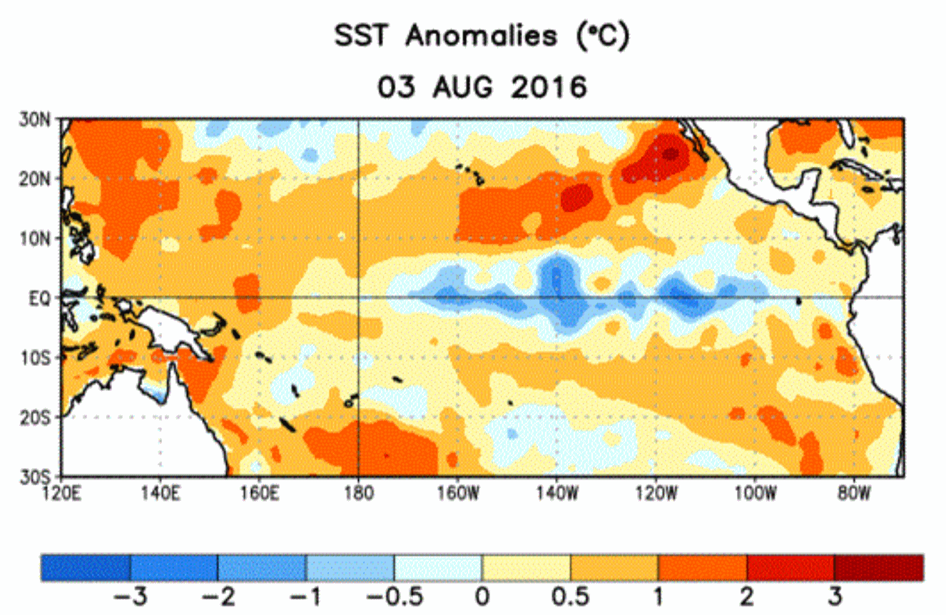 NOAA Maintains La Nina Forecast for Fall or Winter
.
The observed cooling of Pacific ocean water has been tame, the forecast
of official La Nina conditions pushed back, according to
Reuters: "
A
U.S. government weather forecaster on Thursday reduced its outlook that
La Nina conditions would develop in next few months but said it still
expected the weather phenomenon to occur this fall or winter. The
National Weather Service's Climate Prediction Center said in its monthly
forecast that La Nina was "slightly favored" to develop through
October. That was a small change from July, when it stated the
conditions were "favored" to occur. The agency maintained its forecast
of a 55 percent to 60 percent chance that La Nina would develop during
the fall and winter of 2016/17..."
* More details from NOAA CPC
here.
 Surveyed Scientists Debunk Chemtrails Conspiracy Theory
. Here's the intro to a story at
UCI News: "
The
world’s leading atmospheric scientists overwhelmingly deny the
existence of a secret, elite-driven plot to release harmful chemicals
into the air from high-flying aircraft, according to the first
peer-reviewed journal paper to address the “chemtrails” conspiracy
theory. Researchers from the University of California, Irvine, the Carnegie Institution for Science and the nonprofit Near Zero
organization asked 77 atmospheric chemists and geochemists if they had
come across evidence of such a large-scale spraying program, and 76
responded that they had not. The survey results were published Wednesday
in Environmental Research Letters.
Heat from aircraft engines produces condensation trails that can be
clearly seen from the ground. A small but vocal segment of the
population firmly believes that these are composed not merely of
condensed water vapor but of chemicals and elements such as strontium,
barium and aluminum that powerful, high-level entities have been
intentionally and covertly releasing into the atmosphere for decades..."
Photo credit: "
A commercial airliner produces a condensation trail in the skies over California." Mick West
The Superglue Diet: How To Make a Lighter, Fuel-Sipping Car. Here's a clip from
The New York Times: "
The 2017 GMC Acadia
sport utility vehicle that is just starting to arrive in dealerships
around the country is 700 pounds lighter than the version it replaces,
and can go 23 miles on a gallon of gasoline, up from 18 m.p.g., a 28
percent improvement. One of the secrets to the big weight loss? Glue.
Many of the steel parts of the Acadia’s underbody are held together not
by rivets or welds but by advanced adhesives similar to those used in
modern airplanes like the Boeing Dreamliner...."
Photo credit: "
Robots
applied adhesive to bond parts of a GMC Acadia at General Motors’
Spring Hill plant in Tennessee. The glue helps reduce the weight of the
vehicle."
Credit Sanford Myers for General Motors
The Brave New World of Robots and Lost Jobs.
Here's the debate we should be having. Be less worried about bad trade
deals with China - and more worried about AI and intelligent robots
doing your job within 5-10 years.
The Washington Post reports: "...
The
“automation bomb” could destroy 45 percent of the work activities
currently performed in the United States, representing about $2 trillion
in annual wages, according to a study last year by the consulting firm McKinsey & Co.
We’ve seen only the beginning of this change, they warned. Currently,
only 5 percent of occupations can be entirely automated, but 60 percent
of occupations could soon see machines doing 30 percent or more of the
work. The McKinsey analysts sharpened their argument in a paper released last month.
Their estimates, based on U.S. Bureau of Labor Statistics data covering
more than 800 occupations, draw a shocking picture of the future...."
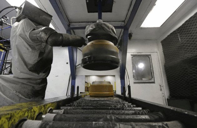
Photo credit: "
A robot paints brake drums at Webb Wheel Products in Cullman, Ala." (Dave Martin/Associated Press).
 TODAY
TODAY: AM sunshine, PM clouds, passing shower or T-shower. Winds: NW 8-13. High: near 80
SATURDAY NIGHT: Clearing skies, risk of a meteor shower. Low: 62
SUNDAY: More sun, a dry, comfortable sky. Winds: NW 5-10. High: 81
MONDAY: Warm sunshine, looking good. Winds: SE 8-13. Wake-up: 65. High: 84
TUESDAY: Unsettled, few T-storms may pop. Wake-up: 68. High: 83
WEDNESDAY: Sunnier, drier, warmer. Winds: NW 5-10. Wake-up: 67. High: 86
THURSDAY: Sticky sun, heating up. Winds: S 8-13. Wake-up: 69. High: near 90
FRIDAY: Few T-storms likely as a cooler front approaches. Winds: SW 8-13. Wake-up: 72. High: 85
Climate Stories...
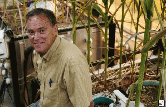
Growing Corn Like It's 2065 To Study Climate Change Effects. The Star Tribune reports: "
At
the University of Minnesota, researchers are growing corn in
greenhouses like it’s the year 2065. The effort is part of a long-term
plan to study how corn will grow under weather conditions considerably
different from today’s, predicted in climate change models for a
half-century out. “Many models show that with increasing temperatures we
could be seeing a reduction in corn yields, so that’s something we
would like to investigate under controlled conditions,” said Tim
Griffis, University of Minnesota professor of biometeorology and one of
several researchers directing projects..."
Photo credit: "Richard TSONG-TAATARII, Star Tribune. "
John Baker of the Agricultural Research Service is studying how climate change may affect crop yields."
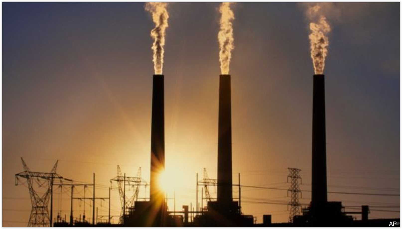 As Earth Swelters, Global Warming Target In Danger of Being Missed.
 Here's the intro to an update at
Reuters: "
The
Earth is so hot this year that a limit for global warming agreed by
world leaders at a climate summit in Paris just a few months ago is in
danger of being breached. In December, almost 200 nations agreed a
radical shift away from fossil fuels with a goal of limiting a rise in
average global temperatures to well below 2 degrees Celsius (3.6
Fahrenheit) above pre-industrial times while "pursuing efforts" for 1.5C
(2.7F). But 2016 is on track to be the hottest year on record, also
buoyed by a natural El Nino event warming the Pacific, according to the
U.N.'s World Meteorological Organization. The first six months were a
sweltering 1.3C above pre-industrial times..." (File photo: AP).
Epic Middle Eastern Heatwave Could Be Global Warming's Hellish Curtain Raiser.
Not the headline I would have written, but there's little doubt that
things are heating up in an already-volatile region of the planet.
Access to clean, reliable water may be a bigger factor that actual air
temperatures and record highs. Here's an excerpt from
Sydney Morning Herald: "
Record-shattering
temperatures this summer have scorched countries from Morocco to Saudi
Arabia and beyond, as climate experts warn that the severe weather could
be a harbinger of worse to come. UN officials and climate scientists
predict that, in coming decades, the region's mushrooming populations
will face extreme water scarcity, temperatures almost too hot for human
survival and other consequences of global warming..."
Photo credit:
"Iraqis
jump off the ruins of an old building into the Tigris River to beat the
heat in Baghdad this month. The temperature in Baghdad reached 47
degrees." Photo: AP.
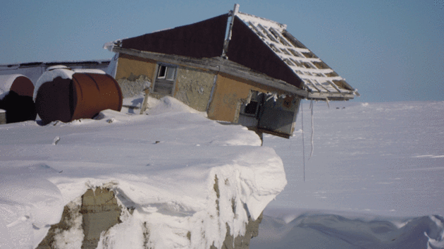
In Picture: Russian Weather Station on the Edge of Melting Permafrost.
Climate Home has the story: "
The
tiny island of Vize in the Kara Sea is fast disappearing as a warming
atmosphere melts Arctic sea ice and the Russian permafrost. That’s the
warning from WWF Russia, which has released pictures of what it says is a
government weather station about to topple into the sea. Since 2009
over 70 metres of coastline has been eroded, said glaciologist Alexander
Aleynikov, a development he describes as “very impressive”..."
Photo credit: "
Vize island weather station on the edge." (Pic: WWF Russia).
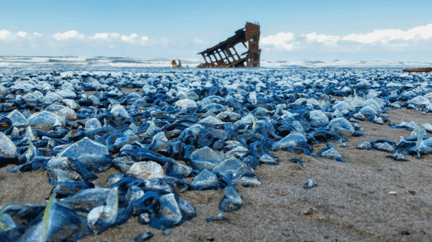
The Blob That Cooked the Pacific. How much is natural vs. influenced by a global warming trend of the atmosphere and oceans? Here's a clip from
National Geographic: "...
As
hotter oceans destroy coral reefs in the tropics and melting ice alters
life in the Arctic, it’s been easy to overlook how much warm water can
reshape temperate seas. No more. Between 2013 and earlier this year,
some West Coast waters grew so astonishingly hot that the marine world
experienced unprecedented upheaval.
Animals showed up in places they’d never been. A toxic bloom of algae,
the biggest of its kind on record, shut down California’s crab industry
for months. Key portions of the food web crashed. It’s not clear if
greenhouse gas emissions exacerbated this ocean heat wave or if the
event simply represented an outer edge of natural weather and climate
patterns..."
Photo credit: "Jellyfish-like
animals known as “by-the-wind sailors” blanket an Oregon beach near an
old shipwreck. Some of the same unusual wind patterns and currents that
recently warmed the Pacific pushed these floating creatures by the
millions onto beaches from Southern California to British Columbia." Photo by Tiffany Boothe, Seaside Aquarium.
Seven Ways Climate Change Affects Our Health. Here's an excerpt of an article from climate scientist Katherine Hayhoe at Huffington Post: "Climate
change is making heat waves stronger and more frequent, air pollution
worse, and allowing vector-borne diseases to expand their range. It’s
also compromising our drinking water, causing more extreme weather
events, and impacting our mental health. And the costs will be great:
just this June, the World Health Organization estimated
that in the twenty years after 2030, climate change will cause
“approximately 250,000 additional deaths per year, from malnutrition,
malaria, diarrhoea and heat stress...”
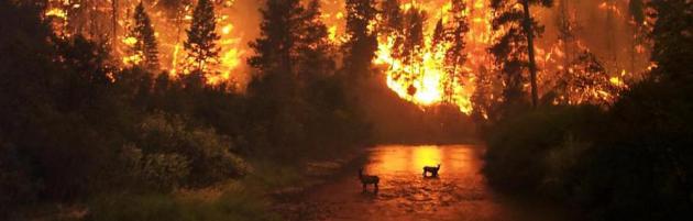
How Climate Change is Increasing Forest Fires Around the World. Here's an excerpt from a story at
Deutsche Welle: "...
So,
have wildfires actually increased globally, or does it just seem that
way because we're tuned in more to bad news and social media? Science
suggests that over the past few decades, the number of wildfires has
indeed increased, especially in the western United States. According to the Union of Concerned Scientists (UCS), every state in the western US has experienced an increase in the average annual number of large wildfires over past decades. Extensive studies
have found that large forest fires in the western US have been
occurring nearly five times more often since the 1970s and 80s. Such
fires are burning more than six times the land area as before, and
lasting almost five times longer..."


Using Car Rental 8 you can discover the cheapest rental cars at over 50,000 international locations.
ReplyDelete