More June Than August - Severe Threat Today - Cool, Saturday Soaking Possible
83 F. high temperature at St. Cloud Wednesday. 80 F. average high on August 17. 74 F. high on August 17, 2015.
August 18, 1953: Four heifers near St. Martin were lucky; a tornado picked them up and set them back down again, unharmed.
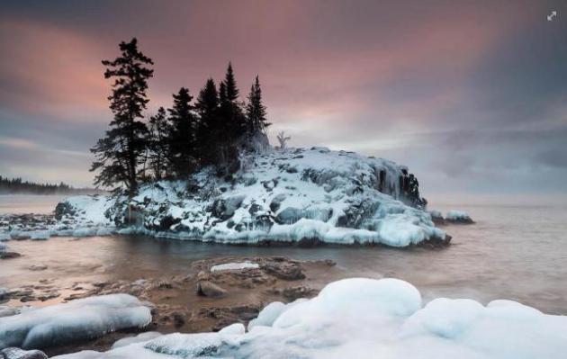
Winter is Coming But Panic Is Optional (and Premature)
Can
you predict where the stock market or interest rates will be the second
week of February, 2017? If so I have a weather forecast I'd like to
sell you. The Old Farmer's Almanac is predicting a harsh, snowy winter
for Minnesota and the Midwest.
"Polar Vortex, The Sequel".
In
my humble opinion the odds of this forecast verifying are less than 1
in 3. It could happen, but odds favor another milder-than-average
winter, with fickle snow cover and fewer subzero nights than average.
This, in spite of a weak La Nina cool phase in the Pacific. There's just
too much warm air and water.
First meteorological rule: persistence (don't buck the trends) - and don't always assume a worst-case scenario.
We've lost 2 hours of daylight since June 21;
nights are cooling off now and a taste of Autumn arrives just in time
for weekend plans. The approach of cooler air sets off strong to severe
T-storms later today and showery rains may linger Friday and Saturday, when rain may be heavy at times. Sunday looks like the drier, nicer day of the weekend.
Rainfall is 3-5 inches above normal since June 1. That's like having an extra month's worth of rain this summer.
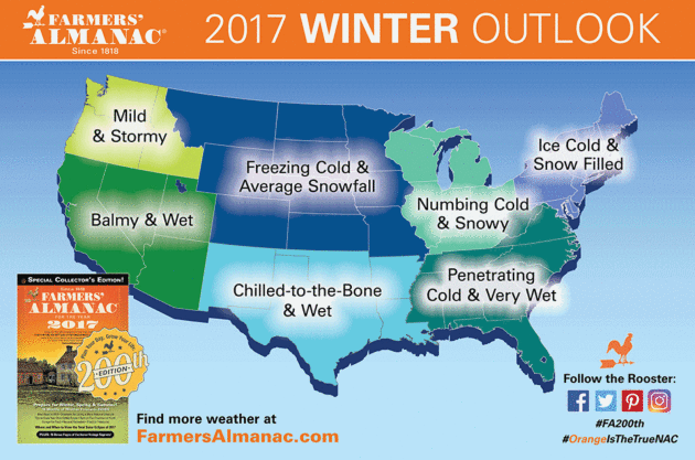
Bitter Winter for Minnesota? Take It With a Grain of (Road) Salt. Here's an excerpt from The Star Tribune: "Minnesota
and much of the rest of the United States are in for an especially
frigid winter, according to the newly released Farmers’ Almanac and its
older rival, which comes out later in August. In its 200th anniversary
edition unveiled Monday, the Farmers’ Almanac said a deep freeze will
grip the Northern Plains, the Great Lakes, the Midwest, the Ohio Valley,
the mid-Atlantic and New England. For a warm winter, head west, said
the folksy, Maine-based publication. A local meteorologist was quick to
call the almanac a curiosity that lacks “scientific validity...” Graphic credit: Farmer’s Almanac
This Is Getting Old.
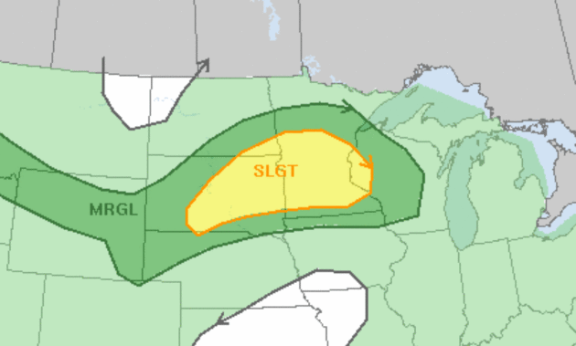
Here's a shocker: there's a slight risk of severe T-storms across
central and southern Minnesota today, the primary risk large hail and 70
mph straight-line wind gusts. And no, we don't need the rain - but it's
coming anyway. Map: NOAA SPC.
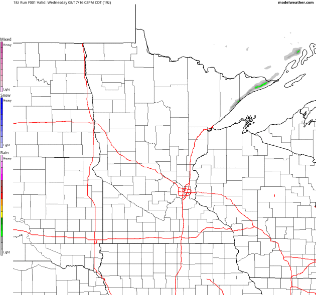
Atmospheric Rocking and Rolling.
NOAA's 4km NAM model shows strong to severe T-storms pushing across the
state during the late afternoon and evening hours. Heavier, steadier
rain is possible late Friday into Saturday as a wave of low pressure
tracks along the leading edge of (much) cooler air. Future Radar: NOAA
and AerisWeather.
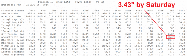
A Computer Typo - I Hope.
The 00z NAM model prints out 3.43" of rain for the Twin Cities by
Saturday evening. Even if it's off by an order of magnitude there's
little doubt we'll pick up at least an inch of rain, maybe significantly
more than that. Have a Plan B (indoors) for Saturday.
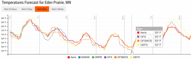
Sweatshirt-Worthy?
Models show wake-up temperatures in the low to mid 50s Monday morning
in the metro area; some 40s up north. Temperatures moderate rapidly next
week. Source: Aeris Enterprise.
Weekend Cool-Down, Mellowing Out Next Week.
If NOAA guidance verifies temperatures may be stuck in the 60s all day
Saturday and most of Sunday as well, the first real taste of autumn is
shaping up. But typical August warmth returns again next week. MSP
Meteogram: WeatherBell.
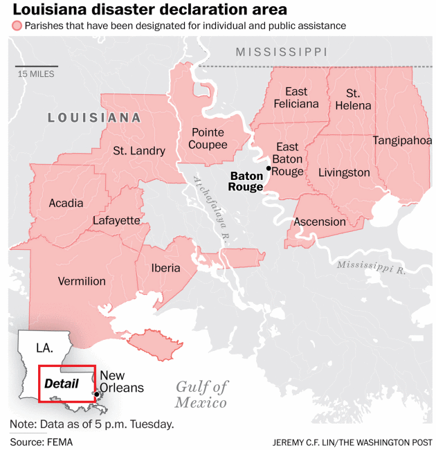
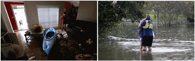
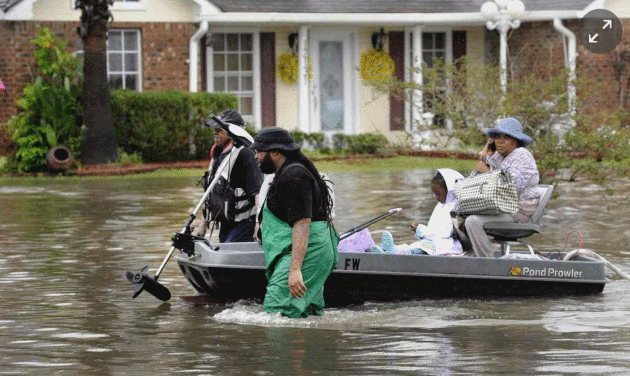
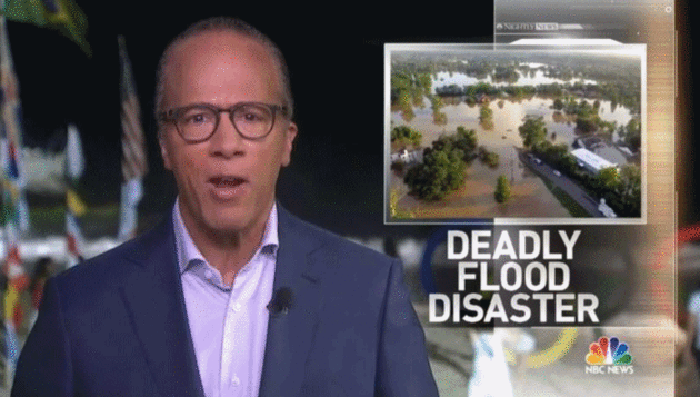
Louisiana Flooding Leaves 11 Dead, Forces Thousands From Their Homes. Here's an excerpt of an update from The Washington Post: "The
waters and the death toll continued to rise Tuesday in rain-battered
Louisiana, as flooding of historic levels swept anew into some
communities and stubbornly lingered in hundreds more. The scope of the
disaster was unprecedented, officials said. At least 40,000 homes had
been damaged, Louisiana’s governor said, and 11 people have been killed
since two feet of rain began falling Thursday night. More than 10,000
people were in shelters, miles of roads remained impassable, the start
of the school year was canceled and first responders began the grim work
of door-to-door inspections to check for drowning victims..."
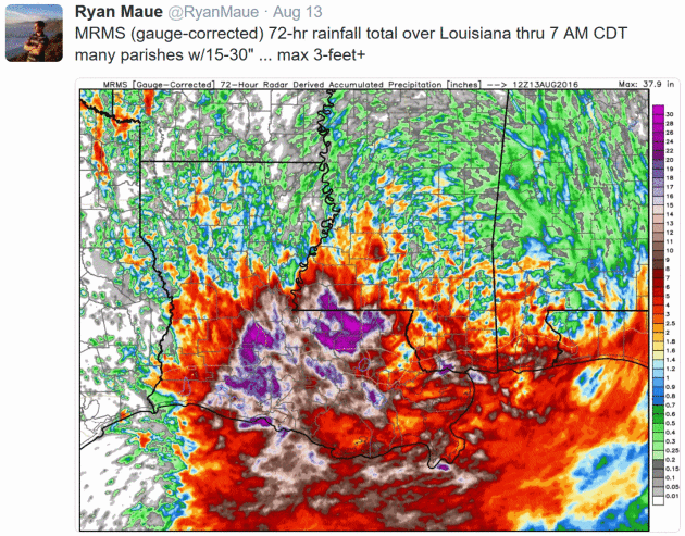
Louisiana Flood of 2016 Resulted from 2-Day, "1,000-Year" Rainfall. NOLA.com in New Orleans has details: "The Louisiana Flood of 2016 was triggered by a complicated, slow-moving low-pressure weather system that dumped as much as two feet of rain on parts of East Baton Rouge,Livingston and St. Helena
parishes in 48 hours. The record two-day rainfall in those areas had a
0.1 percent chance of occurring in any year, the equivalent of a
"1,000-year rain", according to the Lower Mississippi River Forecast Center, based at the Slidell office of the National Weather Service..."
Map credit: "This
color-coded map shows the chance that the 48-hour rainfall totals
through 7 a.m. Saturday have of occurring in any year. The areas marked
white have a 0.1 percent chance of occurring any year, the equivalent of
a so-called 1,000-year rainfall event."
Worst Natural Disaster Since Superstorm Sandy in 2012? So says the American Red Cross: "The
American Red Cross is helping thousands of people in Louisiana affected
by devastating flooding, likely the worst natural disaster since
Superstorm Sandy in 2012. “Relief efforts in Louisiana are challenging
with life-threatening floods and road closures making conditions
dangerous,” said Brad Kieserman, vice president, Disaster Services
Operations and Logistics for the Red Cross. “We are mobilizing a massive
relief effort with volunteers providing shelter, food and comfort right
now. The Red Cross is also sending in additional relief supplies and
volunteers to expand our response in the coming days...”
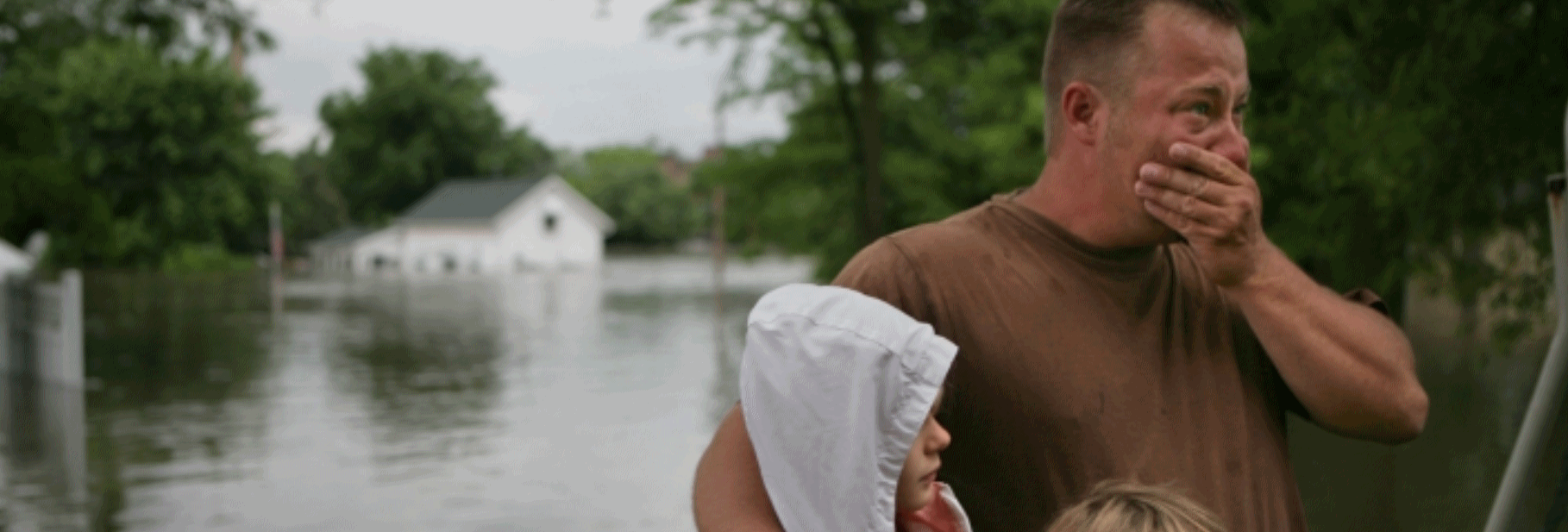
No Words.
It's easy to get hung up on statistics and meteorological explanations
and forget the human tragedy. Hundreds of thousands of Louisiana
residents are being impacted, directly or indirectly. Reuters has a
poignant photo essay that helps to humanize this overwhelming tragedy.
Why The Deadly Louisiana Flood Occurred.
The fact that there was no named tropical system probably added to the
overall lack of preparation for this level of historic flooding. No-name
tropical disturbances that stall for extended periods of time can be
even more damaging (from an inland flooding perspective) as Category 5
hurricanes. Here's an excerpt at Scientific American: "...The
Louisiana storm was a freak event driven by the atmosphere and the
ocean. At present, scientists do not know enough to attribute dynamic
storms of this sort to climate change. But broaden the focus a little,
and some links appear. The frequency and intensity of heavy rainfall
events have increased globally, said Kenneth Kunkel, a climate scientist
at NOAA’s National Centers for Environmental Information. “Each decade,
it has been higher than the previous decade, for about the last 30 to
40 years,” he said. Both the land and the oceans have been warming up,
which has increased the amount of water vapor in the atmosphere, he said..."
U.S. Losses from Hurricanes Set To Soar By 2100. Thinking of retiring on the coast? Might I suggest a nice rental at VRBO.com. Here's an excerpt from Thomson Reuters Foundation: "The
annual cost of damage caused by hurricanes in the United States may
rise eight times by the end of the century, as the number and intensity
of the storms increase on a warmer planet, researchers said on Tuesday.
Globally, tropical cyclones account for more than 50 percent of economic
losses caused by weather. Their impact is projected to increase
"substantially" as the number of people affected grows, incomes rise and
storms worsen, the researchers said. In the United States, the increase
in the cost of hurricanes may even outpace economic growth if climate
change is not curbed, the Germany-based Potsdam Institute for Climate
Impact Research (PIK) said in a paper..."
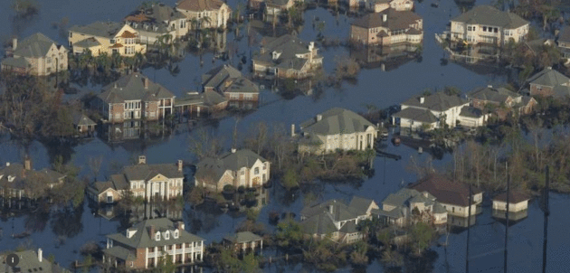
File photo: "In
this file photo, neighborhoods are flooded with oil and water two weeks
after Hurricane Katrina went though New Orleans, September 12, 2005." REUTERS/Carlos Barria.
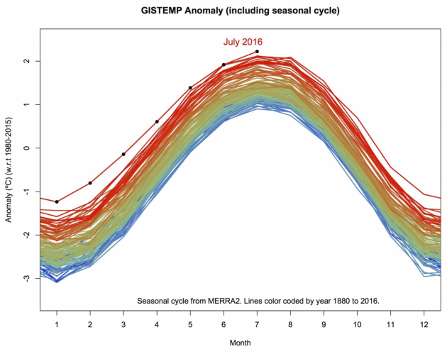
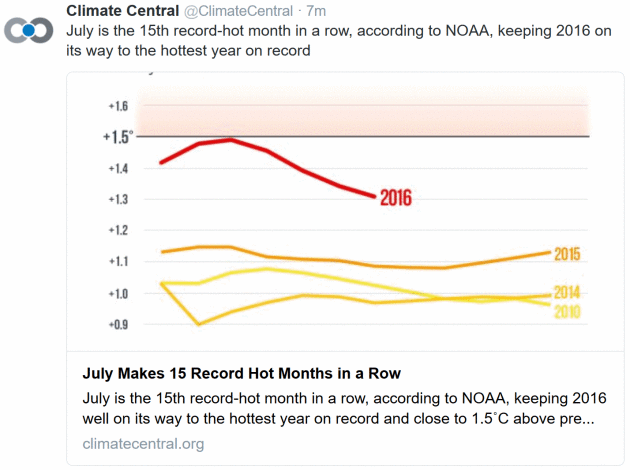
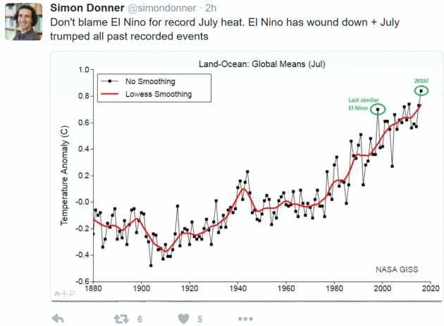
July Was "Absolutely" Earth's Hottest Month Ever Recorded. Capital Weather Gang reports: "NASA
data reveal the Earth’s temperature reached its highest point in 136
years of record-keeping during July. “July 2016 was absolutely the
hottest month since the instrumental records began,” tweeted Gavin Schmidt, who directs NASA’s Goddard Institute for Space Studies,
which is responsible for temperature measurements. It was the
10th-straight month of record-breaking temperatures in NASA’s analysis, a
substantial 0.18 degrees (0.1 Celsius) warmer than the previous hottest
July in 2011. “It’s a little alarming to me that we’re going through
these records like nothing this year,” said Jason Furtado, a professor
of meteorology at the University of Oklahoma..."
Image credit: "Annual global temperatures; each line indicates a year, spanning 1880-2016." (NASA/Gavin Schmidt).
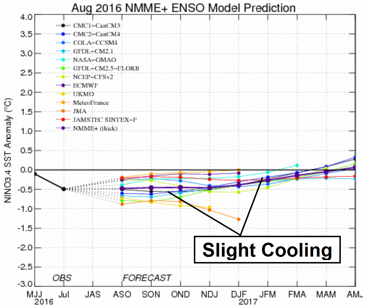
Mild La Nina?
I suspect much of the Farmer's Almanac winter forecast calling for
severe cold is based on the La Nina cool phase in the Pacific, but the
latest forecasts shohw only slight cooling in the months to come.
Graphic: Earth Institute at Columbia University.
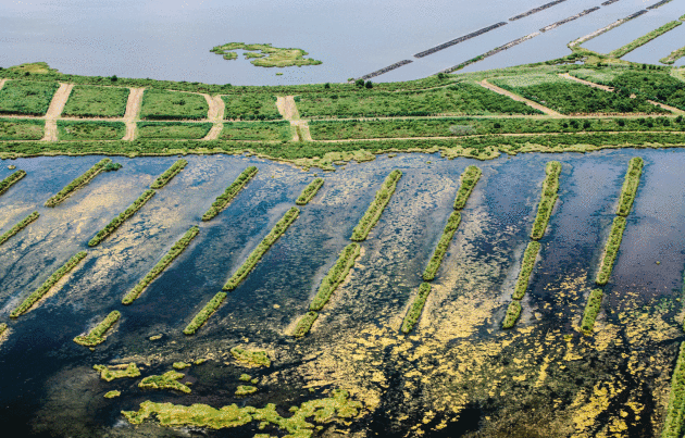
Louisiana's Sinking Coast is a $100 Billion Nightmare for Big Oil. Rising seas, land subsidence - significant infrastructure is threatened in the years to come, according to Bloomberg: "From
5,000 feet up, it’s difficult to make out where Louisiana’s coastline
used to be. But follow the skeletal remains of decades-old oil canals,
and you get an idea. Once, these lanes sliced through thick marshland,
clearing a path for pipelines or ships. Now they’re surrounded by open
water, green borders still visible as the sea swallows up the shore. The
canals tell a story about the industry’s ubiquity in Louisiana history,
but they also signal a grave future: $100 billion of energy
infrastructure threatened by rising sea levels and erosion. As the
coastline recedes, tangles of pipeline are exposed to corrosive
seawater; refineries, tank farms and ports are at risk..."
Photo credit: "A
restoration site for eroded wetlands near the town of Pointe Aux
Chenes, an unincorporated community located in south Terrebonne Parish." Photographer: William Widmer/Redux.
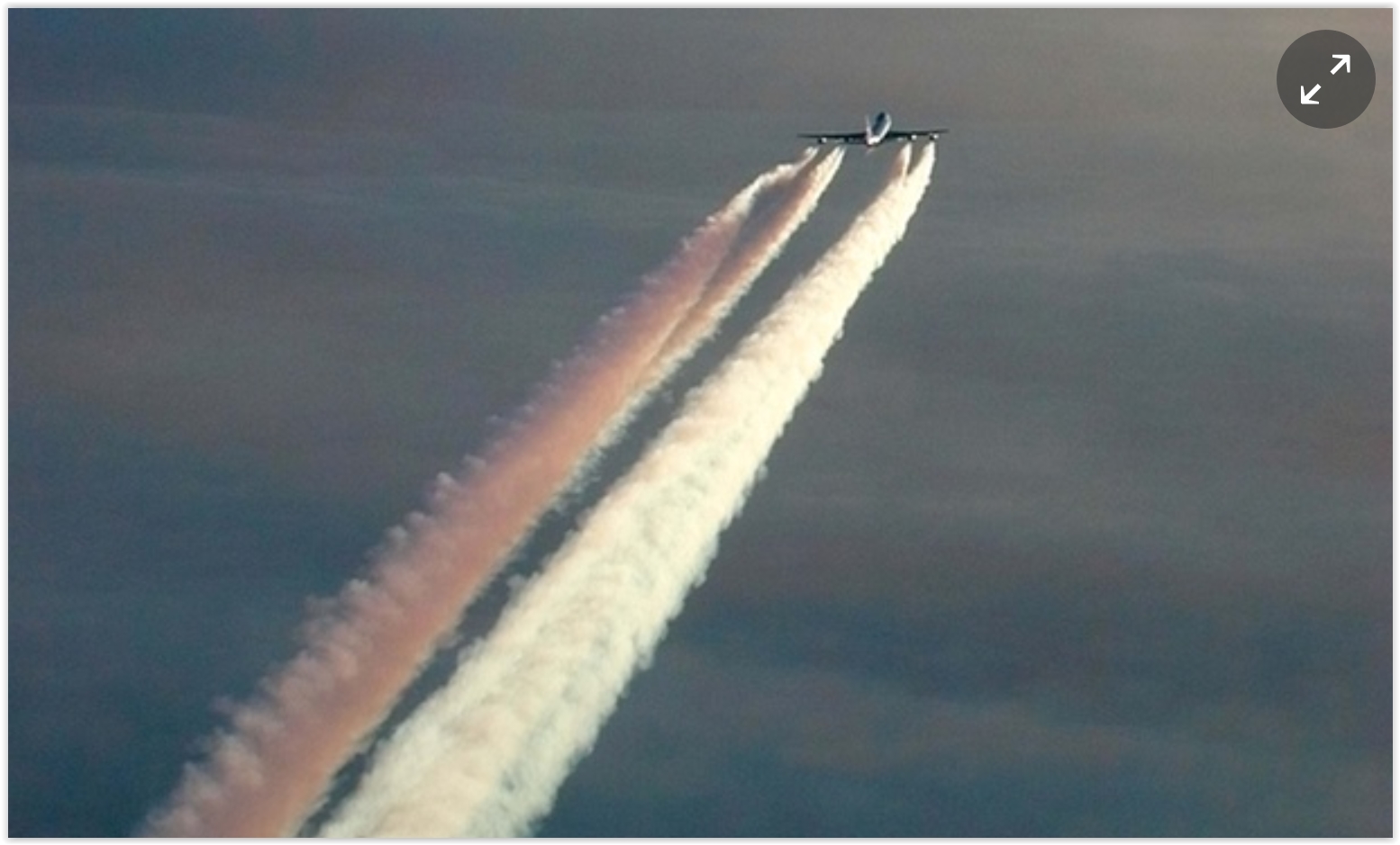
Scientists Just Say No to "Chemtrails" Conspiracy Theory.
Is the government really experimenting on us? Call me crazy, but I
doubt it - so do most scientists who have studied this. Here's the
intro to a New York Times story: "Conspiracy
theories can be stubborn, particularly in the echo chamber of the
internet. One persistent belief in some quarters is that the government —
or business, perhaps — is deploying a fleet of jet aircraft to spray
chemicals into the sky to control the population, food supply or other
things. As evidence, they point to what they call “chemtrails,” which
are more commonly known as contrails, or condensation trails, produced
at high altitudes as water vapor in jet engine exhaust condenses and
freezes..." (Image: Alamy).
Donald Trump's Lack of Respect for Science is Alarming. So says Scientific American; here's a clip from a recent post: "...The
current presidential race, however, is something special. It takes
antiscience to previously unexplored terrain. When the major Republican
candidate for president has tweeted that global warming is a Chinese
plot, threatens to dismantle a climate agreement 20 years in the making
and to eliminate an agency that enforces clean air and water
regulations, and speaks passionately about a link between vaccines and
autism that was utterly discredited years ago, we can only hope that
there is nowhere to go but up..."
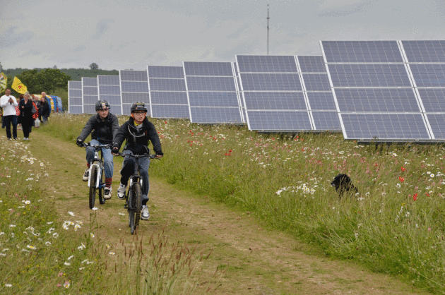
It's the Dawn of the Community Solar Farm. Here's a clip from Bloomberg Markets: "It’s
like rooftop solar, without the rooftops. A growing number of consumers
are buying into community solar farms that allow renters and apartment
dwellers to access renewable energy produced on neighborhood plots that
can be small enough to host a little league baseball game. Some are so
modest they’re referred to as “solar gardens.” Conventional solar farms
such as Berkshire Hathaway Inc.’s 550-megawatt Topaz plant in
California can spread over hundreds or thousands of acres. They sell
their electricity mainly to utilities through long-term contracts.
Rooftop panels, meanwhile, are mainly available for private homes, and
can only work on about 30 percent of U.S. houses. Community farms offer a
middle road..." (Photo: Wikipedia)
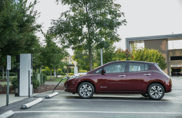
Shorter-Range Electric Cars Meet the Needs of Almost All U.S. Drivers. Here's a clip at Ars Technica: "The
vast majority of American drivers could switch to battery electric
vehicles (BEVs) tomorrow and carry on with their lives unaffected,
according to a new study in Nature Energy. What's more, those BEVs need
not be a $100,000 Tesla, either. That's the conclusion from a team at
MIT and the Santa Fe Institute in New Mexico that looked at the
potential for BEV adoption in the US in light of current driving
patterns. Perhaps most interestingly, the study found that claim to be
true for a wide range of cities with very distinct geography and even
per-capita gasoline consumption..." (Photo credit: Nissan).
* The paper referenced in the Ars Technica article above is here.
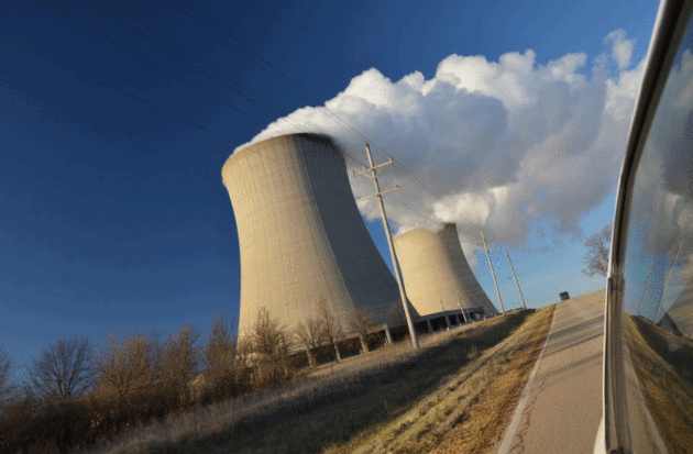
What's The Future of Nuclear in the Midwest? A State-by-State Look.
Call me crazy but if we want to lower CO2 levels quickly we will need
some level of nuclear power, until clean renewables are at scale, which
is going to take more time, in spite of great technology, tumbling
prices and consumer demand. Here's an excerpt from a story at Midwest Energy News: "...Minnesota,
also a regulated state, has two nuclear plants, Prairie Island and
Monticello. Both are owned by Xcel Energy and they provide about 30
percent of the energy for Xcel’s upper Midwest customers, not all of
them in Minnesota. Minnesota also has a moratorium on new nuclear
plants, but some have pushed to lift it, specifically to build another unit at Monticello. Xcel Energy has said it could close Prairie Island before its license expires in
2033/2034, because of increased expenditures required to make upgrades
required in response to the Fukushima Daiichi disaster, and other
federal requirements..." (Photo credit: The Byron nuclear plant in Illinois.)
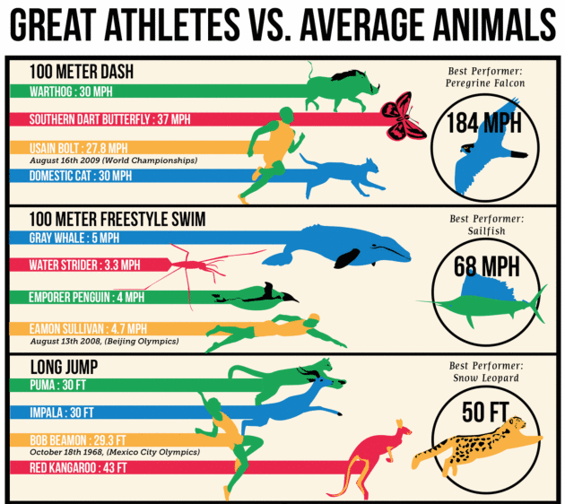
A Visual Guide to How Terribly the World's Best Human Athletes Fare Versus Most Average Animals. We're not as impressive as we think we are. Here's an excerpt from Atlas Obscura: "...But the world's most extraordinary human runner would not beat, say, an ordinary warthog. A warthog can run around 30 miles per hour on an average day—no training, no audience, no special wind conditions. Housecats also regularly reach this speed, as do grizzly bears, rabbits, and white-tailed deer. The roadrunner can run 25 mph even though it can also fly. A certain class of butterflies, called skippers,
can get up to 37. The Olympics may have us all misty-eyed at the
heights (and lengths, and speeds, and depths) of human achievement. But
if we were ever to open the stadium gates to the whole animal kingdom,
we'd quickly be put back in our place..."
Graphics credit: Michelle Enemark.
The Most Inaccessible Places In The World People Desperately Want to Visit. Here's an excerpt from Atlas Obscura: "...For
beer lovers, Starkenberger's Castle is one of only a few places in the
world where they can truly, literally, immerse themselves in beer. As
such it is a obviously a desirable travel destination. So why have no
Atlas users bathed in the hoppy aroma of "world’s only
beer-swimming-pools?” These 13-foot pools, each containing 42,000 pints
of warm beer (with some water) are the most unique attraction at the
beer-themed castle—and not just a gimmick. The beer is rich in vitamins
and calcium, and it is said that sitting in it is good for the skin and
helps cure open wounds and psoriasis..."
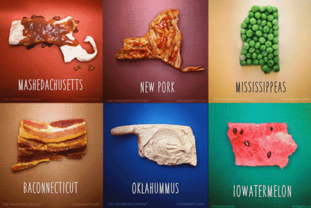
All 50 States Reimagined as Food Puns. Ramennesota? I defy you to check this out and not get hungry. Mental Floss has details: "If
you had to assign one piece of food to represent each state, which item
would you pick? For the good people at Foodiggity, the answer is
whatever is punniest. Armed with a set of state-shaped cookie cutters
and a love of wordplay, the team set out to make each state out of a
food. The series, called The Foodnited States of America,
features all 50 states. The project came about when Foodiggity founder
Chris Durso's young son suggested they make states out of food..." (Image credit: food diggity).
TODAY: Some sticky sun, watch for severe storms late. Winds: S 8-13. High: 88
THURSDAY NIGHT: Few heavy to severe T-storms in the area. Low: 70
FRIDAY: More showers, possible T-storms. Winds: NW 8-13. High: 76
SATURDAY: Cold rain, heavy at times. Winds: NW 10-15. Wake-up: 60. High: 66
MONDAY: Sunny and milder. Winds: SE 8-13. Wake-up: 57. High: 79
TUESDAY: Warm sun, feels like August again. Winds: S 10-20. Wake-up: 64. High: 85
WEDNESDAY: Showers and T-storms likely. Winds: S 10-15. Wake-up: 67. High: 82
Climate Stories...
Disasters Like Louisiana Floods Will Worsen as Planet Warms, Scientists Warn. Here's an excerpt from The Guardian: "...There’s
a very tight loop – as surface temperatures of the oceans warm up, the
immediate response is more water vapor in the atmosphere. We’re in a
system inherently capable of producing more floods.” The number of heavy
rainfall events in the US has risen well above the long-term average since the 1990s,
with large regional variances. While the north-east, midwest and upper
great plains have experienced a 30% increase in heavy rainfall episodes –
considered once-in-every-five year downpours – parts of the west,
particularly California, have been parched by drought. Warmer air,
influenced by heat-trapping gases released by human activity, can
contain more water vapor than cooler air..."
Photo credit: "Close
to two feet of rain fell over a 48-hour period in parts of southern
Louisiana, causing residents to scramble to safety from flooded homes
and cars." Photograph: John Oubre/AP.
Nightly Newscasts Ignore Climate Change in Coverage of Worst U.S. Weather Disaster Since Hurricane Sandy. Here's the intro to a story at Media Matters: "The major U.S. broadcast news networks have all ignored climate change in their nightly news coverage of Louisiana's recent record-breaking
rainfall and flooding. The New York Times and The Washington Post, by
contrast, have explained how the extreme weather and flooding in
Louisiana are in line with the predicted impacts of a warming planet.
The disaster in Louisiana killed at least 11 people and displaced thousands more. The American Red Cross described
the state’s flooding as “the worst natural disaster to strike the
United States since Superstorm Sandy,” and the National Oceanic and
Atmospheric Association classified the record rainfall as a once-in-every-500-years event -- the eighth such event to take place in the U.S. since May 2015..."
Can We Economically Outgrow Climate Change Damages? Not For Hurricanes We Can't. Here's the intro to a story at phys.org that caught my eye: "When
hurricanes like Katrina in 2005 or Sandy in 2012 impact on highly
populated regions they bring about tremendous damages. More than 50% of
all weather-related economic losses on the globe are caused by damages
due to tropical cyclones. Researchers from the Potsdam Institute for
Climate Impact Research (PIK) now analyzed the magnitude of future
hurricane losses in relation to economic growth. Showcasing the United
States they found that financial losses per hurricane could triple by
the end of the century in unmitigated climate change, while annual
losses could on average rise by a factor of eight. Most importantly and
contrary to prevalent opinion, they conclude that economic growth will
not be able to counterbalance the increase in damage..." (File image: NASA).
Bracing Ourselves For The Climate Tipping Point. Has that inflection point already arrived? Here's an excerpt of a post from Eric Holthaus at Pacific Standard: "...So,
what does it mean that we’re now in uncharted territory? And have we
already come too far to avoid key planetary tipping points? What hope
should we have that we’ll fix this sooner rather than later? This week,
scientists are gathering in Geneva, Switzerland, in an attempt to
answer these questions. That we’ve reached a new, increasingly urgent
phase of global warming is becoming apparent after a surge of millennial-scale floods, ecosystem collapses, and record-strong cyclones — all within the last year, coinciding with what’s likely to become the warmest year on record. The planet seems at the breaking point, with increasing evidence
that we’ve already locked in additional warming that will take us
further into uncharted territory — assuming we don’t rapidly change
course..." (File photo: Shutterstock).
Are We Feeling Collective Grief over Climate Change? Here's an excerpt of a guest post at Scientific American: "...That's
not where most people are with climate," Dr. Van Susteren states. "It
takes a long time for some people to lay down the sense within that
something is true." Yet she speaks of a collective anxiety that is
insidious, even if we haven't managed to connect all the dots. "There
isn't the slightest shred of doubt in my mind, that everyone on some
level is anxious, deeply anxious, about climate change," the forensic
psychiatrist says. She attributes her belief to decades of experience
with people who have difficulty knowing what they are feeling on a
deeper level, and she understands that anxiety comes from many
headwaters..." (File image: NASA).
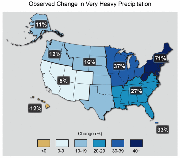
What We Can Say About the Louisiana Floods and Climate Change. Chris Mooney connects the dots at The Washington Post; here's an excerpt: "...Observations
over the US and many other places around the world show that heavy rain
events have been becoming heavier over the last several decades.
Climate models very consistently predict that this should happen as the
climate warms, and basic physics leads us to interpret this change as,
in large part, a consequence of increasing water vapor in
the atmosphere,” explains Adam Sobel, a climate scientist at Columbia
University. “On this basis we can say that climate change has most
likely increased the probability of an event like this. One still can’t
say that climate change ’caused’ this event, as each event has many
causes and no event can be viewed solely as a consequence of long-term
trends...”
Map credit above: "The
map shows percent increases in the amount of precipitation falling in
very heavy events (defined as the heaviest 1% of all daily events) from
1958 to 2012 for each region of the continental United States. (Figure
source: updated from Karl et al. 2009)." Image source: 2014 National Climate Assessment.
World's Hottest Month Shows Challenges Global Warming Will Bring. The Guardian reports: "In Siberia, melting permafrost released anthrax
that had been frozen in a reindeer carcass for decades, starting a
deadly outbreak. In Baghdad, soaring temperatures forced the government
to shut down for days at a time. In Kuwait, thermometers hit a record 54C (129F). July was the hottest month the world has endured since records began in 1880, scientists have said,
and brought a painful taste of the troubles people around the world may
have to grapple with as global warming intensifies. Results compiled by
Nasa showed the month was 0.84C hotter than the 1951-1980 average for
July, and 0.11C hotter than the previous record set in July 2015..."
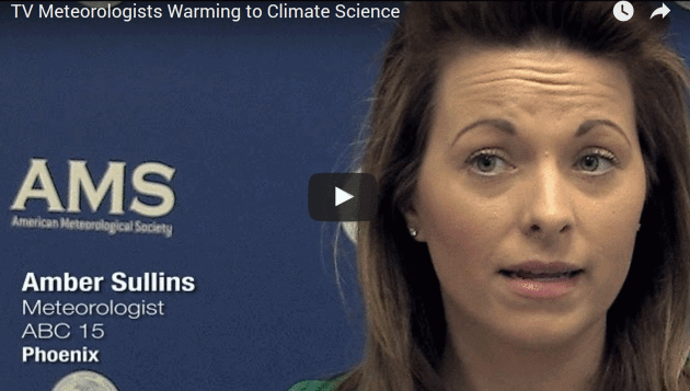
TV Meteorologists Seen Warming to Climate Science. Here's an excerpt from Yale Climate Connections: "Through
their own words in a series of in-person and Skype interviews, plus
clips from some recent broadcasts on extreme weather events, independent
videographer Peter Sinclair’s video describes the rapidly evolving
perspectives: prominent national and local broadcast meteorologists
saying they now see it as their responsibility to keep certain weather
events in the context of the changing climate. The TV weathercasters
featured in the video relate how their views on the science of climate
change have evolved in recent years. “I think you’re seeing more and
more TV meteorologists understand that responsibility,” says Washington
Post meteorologist Jason Samenow..."


No comments:
Post a Comment