82 F. high on Sunday at KSTC.
81 F. average high on August 7.
83 F. high temperature on August 7, 2015.
August 8, 1930: A record high of 102 is set at Redwood Falls.
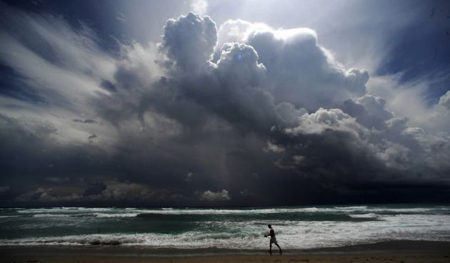
Increasingly Warm and Sticky, then Weekend ReliefWhat
keeps me up at night? The statistical inevitability of an EF-4 tornado
hitting the downtown core of a big city. A western fire growing out of
control, igniting close-in suburbs. A large urban area running out of
water. And "Hurricane Amnesia". It's been a decade since the U.S. was
hit by a Category 3 storm or stronger. Hubris. Overconfidence.
"Technology will save us from a series of poor decisions". Right.
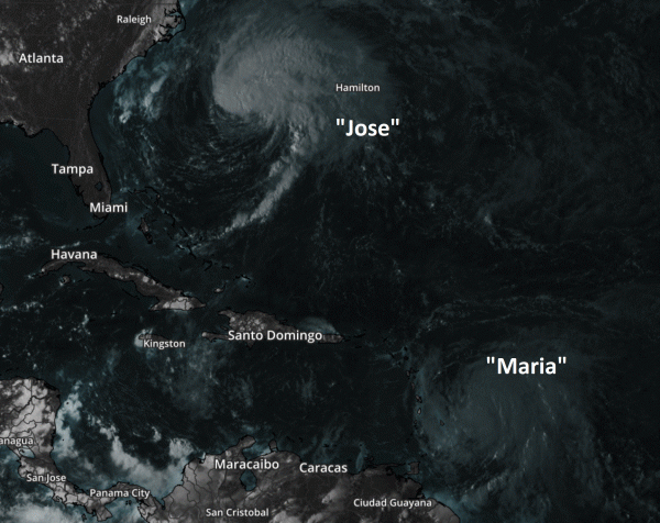
Track
and intensity of a storm is obviously important. But SPEED can be an
even better predictor of impacts, especially rain amounts. When systems
stall, bad things result. That may be the case along the Gulf Coast and
Florida Panhandle this week, with some 10-20 inch rain amounts. No
hurricane or tropical storm, just a stalled tropical low unleashing more
biblical rains.
We heat up into midweek; 90F possible
Wednesday before T-storms and a cool frontal wind shift drop high temperatures into the 70s next weekend with a slow clearing trend.
The
worst of the heat wave stays to our south; stormy ripples on the
northern edge of this sizzling air keeps us wetter than average.
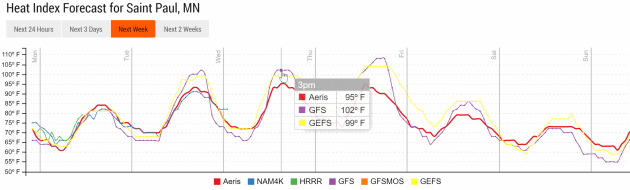
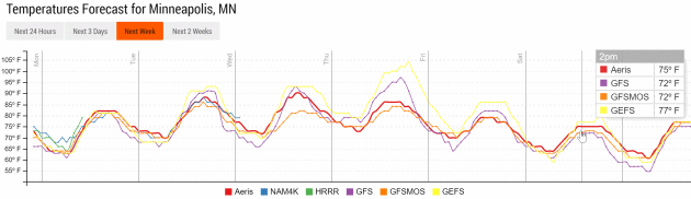
Midweek Sauna.
Models show a heat index well into the 90s by Wednesday and Thursday,
when T-storms may break the heat. A significant cool-down is likely by
the end of the week. Graphic: Aeris Enterprise.
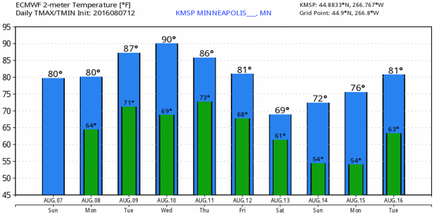
Big Temperature Swings.
After sweating it out Tuesday into Thursday temperatures cool off by
the weekend as surface winds blow from the northwest again, another
cool, Canadian kiss with highs in the 70s and lows dipping into the 50s.
ECMWF forecast: WeatherBell.
Cool
Nights by Friday. If you're heading north next weekend consider a light
jacket or sweatshirt - nights will be cool and crisp with lows in the
50s, even a few 40s possible over the Minnesota Arrowhead.
Aeris Weather Briefings: Issued Sunday afternoon, August 7, 2016.
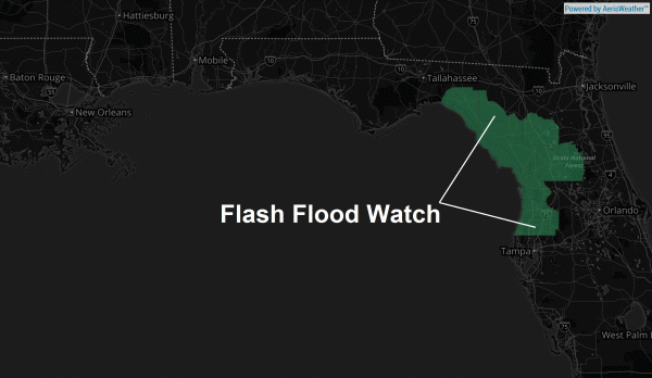
* Stalled tropical disturbance expected to drop a
hurricane's worth of rain on northern Florida and portions of the Gulf Coast this week.
*
10-15" rainfall totals can't be ruled out by next weekend, when rains will finally begin to wind down.
*
I expect serious, even historic flooding of urban areas, rivers and
streams later this week. Urban areas impacted will include
Tampa,
Ocala,
Panama City,
Pensacola,
Mobile and metropolitan
New Orleans. Facilities that experience flooding problems during tropical storms or hurricanes can anticipate problems this week.
Atmospheric Holding Pattern.
As we've discussed in previous briefings when weather stalls bad things
often result. Such will be the case this week as an area of tropical
low pressure rotates over the Gulf Coast, waves of heavy showers and
T-storms continuing to reform and push ashore with potentially record
rainfall totals by next weekend, especially over the Florida Panhandle.
First of (Many) Watches and Warnings.
Our confidence levels are high that significant flooding will be
reported along the Gulf Coast and Florida Panhandle this week, in spite
of no formal tropical storm or hurricane. Which underscores the reality
that the speed of a system can be even more important than the intensity
or track, at least when it comes to rainfall totals. (Graphic: Aeris
Enterprise).
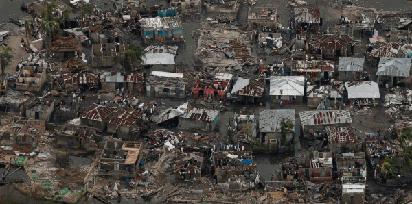
Why We're So Concerned.
All models show excessive rainfall amounts, including ECMWF (European)
guidance, which often does a better job, overall, than NOAA models when
it comes to tropical systems. No model is infallible, but we've seen
several days in a row of model rainfall predictions in excess of 10"
from near New Orleans and Mobile to Pensacola, Panama City and the
northern suburbs of Tampa and Clearwater. This stealthy, "no-name" storm
may result in greater impacts from heavy rain and subsequent flooding
than any named storm ever could. (Graphic credit above: WeatherBell).
We'll keep you posted - another update on Monday.
Paul Douglas, Senior Meteorologist, AerisWeather
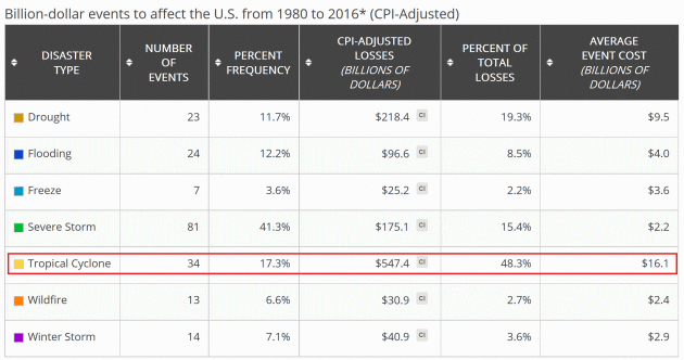
Billion Dollar Weather Disasters Since 1980. Dollar-adjusted damage from tropicals systems exceed all other forms of severe weather combined, according to data from
NOAA NCDC: "
The
distribution of damage from U.S. Billion-dollar disaster events across
the 1980-2016 period of record (as of July 2016) is dominated by
tropical cyclone losses. From 1980-2016, land falling tropical cyclones
have caused the most damage ($547 billion, CPI-adjusted) and also have
the highest average event cost ($16.1 billion per event, CPI-adjusted).
Drought ($218 billion, CPI-adjusted), severe storms ($175 billion,
CPI-adjusted) and inland flooding ($97 billion, CPI-adjusted) have also
caused considerable damage based on the list of billion-dollar events.
It is of note that severe storms are responsible for the highest number
of billion-dollar disaster events (81) yet the average event cost is
among the lowest ($2.2 billion, CPI-adjusted) but still substantial.
Tropical cyclones and drought represent the second and third most
frequent event types (34 and 23), respectively..."
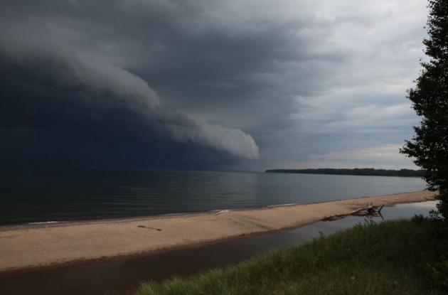
July: Much Wetter Than Average for Much of Minnesota. So says Dr. Mark Seeley in the latest edition of
Minnesota WeatherTalk: "...
The
monthly total rainfall was above normal for most places in the state,
except for a few northern communities which were drier than normal. Many
climate observers reported total monthly rainfall that was 2-3 times
normal, and on a statewide basis it was the 4th wettest July in history
and wettest since 1993. For many communities it was the wettest July in
history, including:
11.65 inches at Brainerd
10.02 inches at Mora
13.44 inches at Garrison
11.14 inches at Longville
9.92 inches at Bruno
9.88 inches at Morris
9.12 inches at St James
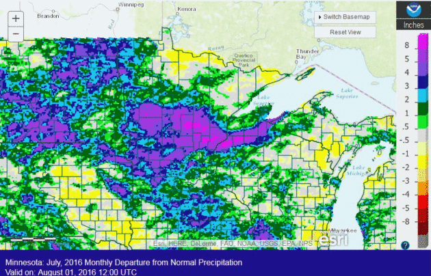
July Weather Recap from Minnesota HydroClim. Here's an excerpt from the
latest update, courtesy of the Minnesota DNR and State Climatology Office: "...
It
was a wet and stormy July for many sections of Minnesota. Precipitation
totals in July were well above normal across central, parts of northern
and south central Minnesota. The rest of the state was close to normal.
Central Minnesota was the wettest with Mora in Kanabec County seeing
10.02 inches of rain and Brainerd in Crow Wing County seeing 11.65
inches of rain for the month. Normal July precipitation for these areas
is about four inches. The last two weeks of July were relatively dry in
some southwest Minnesota counties, with some locations seeing a half an
inch or less..."
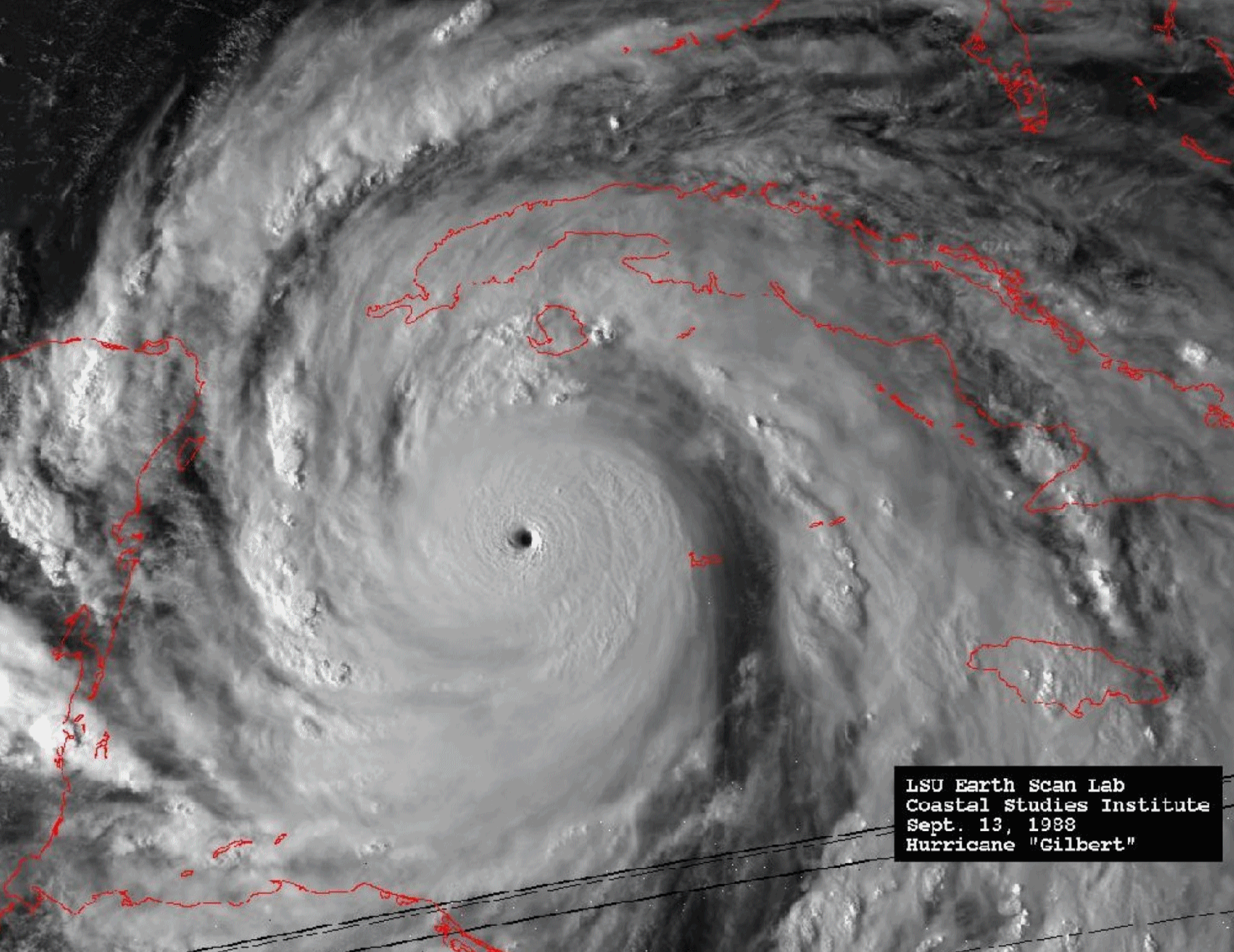 How Soviet and American Hurricane Fliers Set Aside Cold War Politics for Science
. Jack Williams has a fascinating story at
Capital Weather Gang; here's a clip that made me do a double-take: "...
Unknown
to the United States before Gilbert, Russian airplanes had flown out of
Cuba into Hurricane Emily in 1987, Hurricane Floyd and Tropical Storm
Chris the month before Gilbert. After Gilbert in 1988, the Russians flew
into Hurricanes Gabrielle and Hugo, Tropical Storm Iris and Hurricane
Jerry in 1989. In 1990, they flew into Hurricane Klaus and Tropical
Storm Marco. The Russians also flew into several Pacific Ocean typhoons
out of the Democratic Republic of Vietnam (commonly called North Vietnam
in the United States) from 1984 until 1990. They didn’t risk conflicts
with U.S. hurricane hunters; the United States had ended typhoon flights
in 1987..."
Image credit: "
Hurricane Gilbert, 1988." (National Oceanic and Atmospheric Administration).
This Company Has Built a Profile On Every American Adult. This article from
Bloomberg scores a 10 on the creep-o-meter; here's an excerpt: "...
IDI,
a year-old company in the so-called data-fusion business, is the first
to centralize and weaponize all that information for its customers. The
Boca Raton, Fla., company’s database service, idiCORE, combines public
records with purchasing, demographic, and behavioral data. Chief
Executive Officer Derek Dubner says the system isn’t waiting for
requests from clients—it’s already built a profile on every American
adult, including young people who wouldn’t be swept up in conventional
databases, which only index transactions. “We have data on that
21-year-old who’s living at home with mom and dad,” he says..."

 TODAY
TODAY: Partly sunny, balmy. Winds: SE 10-15. High: 82
MONDAY NIGHT: Partly cloudy and mild. Low: 70
TUESDAY: Hotter, stickier, stray T-storm possible. Winds: SW 8-13. High: 88
WEDNESDAY: Hot sun, still muggy. Winds: SE 10-15. Wake-up: 72. High: near 90
THURSDAY: Best chance of heavy T-storms all week. Winds: S 10-20. Wake-up: 74. High: 84
FRIDAY: Blue sky, more comfortable breeze. Winds: NW 10-20. Wake-up: 70. High: 82
SATURDAY: Morning sun, PM clouds, shower. Winds: NW 10-15. Wake-up: 62. High: 76
SUNDAY: Sunnier, nicer day of the weekend. Winds: NW 5-10. Wake-up: 58. High: 78
Climate Stories...
Scientists Warn World Will Miss Key Climate Target. The warming appears to be accelerating, with or without an El Nino turbo-boost. Here's an excerpt from
The Guardian: "...
However, figures – based on Met Office data – prepared by meteorologist Ed Hawkins of Reading University
show that average global temperatures were already more than 1C above
pre-industrial levels for every month except one over the past year and peaked at +1.38C in February and March. Keeping
within the 1.5C limit will be extremely difficult, say scientists,
given these rises. These alarming figures will form the backdrop to the
Intergovernmental Panel on Climate Change talks in Geneva this month,
when scientists will start to outline ways to implement the climate
goals set in Paris. Dates for abandoning all coal-burning power stations
and halting the use of combustion engines across the globe – possibly
within 15 years – are likely to be set..."
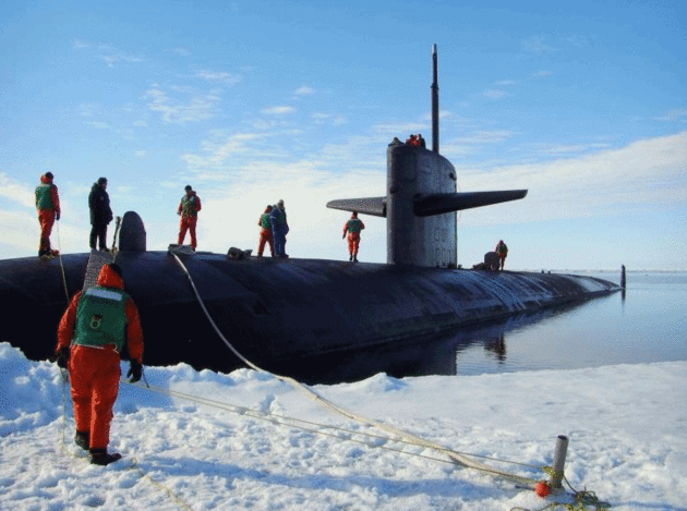
Climate Change Has Produced a New Underwater Sound Superhighway. I had no idea, but a story at
Nautilus brought me up to speed; here's a clip: "
In
March, a team of scientists dragged a blast furnace on a sled across a
giant slab of ice in the Beaufort Sea, above the Arctic Circle. With the
furnace, the researchers (from the United States Navy and the
Massachusetts Institute of Technology) melted a hole in the ice big
enough to fit their 850-pound, 12-foot drone,
which they dropped through to the icy waters below. Their mission: to
measure how climate change is altering the acoustics of the Arctic Ocean..."
Photo credit: "
The USS Providence in the Arctic Ocean." Marion Doss / Flickr
In Olympics Opening Ceremony, Brazil Goes Big on Climate Change. The Washington Post reports: "
Amid
the pomp and circumstance of the opening ceremony of the Olympic Games
on Friday, in between the fireworks and musical acts, the costumed
performers and the camera shots of Gisele Bundchen dancing giddily
alongside her fellow Brazilians in the crowd, came a more
somber message. In primetime, with the world watching, Brazil showed a
video focused on the problem of global warming and climate change. The
video, narrated by Academy Award-winning actor Judi Dench, included maps
and graphics showing how rapidly the earth’s temperature has
spiked over time, how drastically the Antarctic ice sheet has wilted in
recent decades and how steadily seas are rising around the globe..."
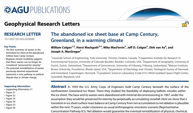
Global Warming Threatens to Release Nuclear Waste from Cold War Base in Greenland. A story at the
U.K. Telegraph had me doing a double-take: "
Nuclear waste buried underneath the ice in Greenland in a Cold War-era bunker is at risk of being exposed, scientists fear, due to global warming.
Radioactive coolant, thousands of gallons of sewage and diesel fuel,
and tons of PCBs – a chemical coolant, banned in 1979 - were abandoned
at the US Camp
Century base when it was decommissioned in 1967. The Americans left the
base nearly fully intact, under the assumption that it would be buried
forever under accumulated snowfall..."
* The paper from AGU Publications is
here.
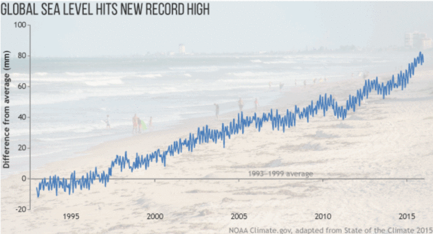
Global Sea Level Hits New Record High. Here's an excerpt from
NOAA's climate.gov: "...
The
graph (above) shows yearly global sea level since 1993 compared to the
1993–1999 average line (gray line at zero). Sea level has risen at an
average rate of 0.33 centimeters (0.1 inches) per year since the
satellite altimeter record began in 1993, which is faster than the rate
of rise in the early part of the twentieth century. Some ocean regions
are rising faster than others. Regions with high rates of sea level rise
in recent years include the western Pacific and Indian Oceans, while
some areas of the eastern Pacific, Southern, and North Atlantic Oceans
have experienced no change or falling sea level..."


No comments:
Post a Comment