_______________________________________________
Supernaturally Soggy Pattern Hangs On This Week
By Paul Douglas
By Paul Douglas
Local landscaping guru Mike Henslin asked me a thoughtful question: "Do wet summers increase the odds of a wet winter?" I sure hope not. And I have not seen a scientific link between soggy summers and snowfall amounts the following winter.
An El Nino warm phase in
the Pacific correlates with slightly milder winters for Minnesota. Last
winter's warmth was influenced by El Nino, but the La Nina cool phase
predicted for the upcoming winter has fizzled. Which means flip a coin,
but it probably won't be as mellow and Kansas City-like as last winter.
Just a gut feel. Could be nausea.
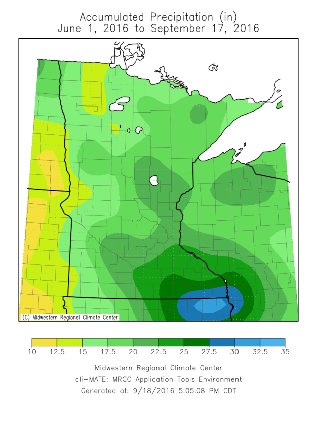
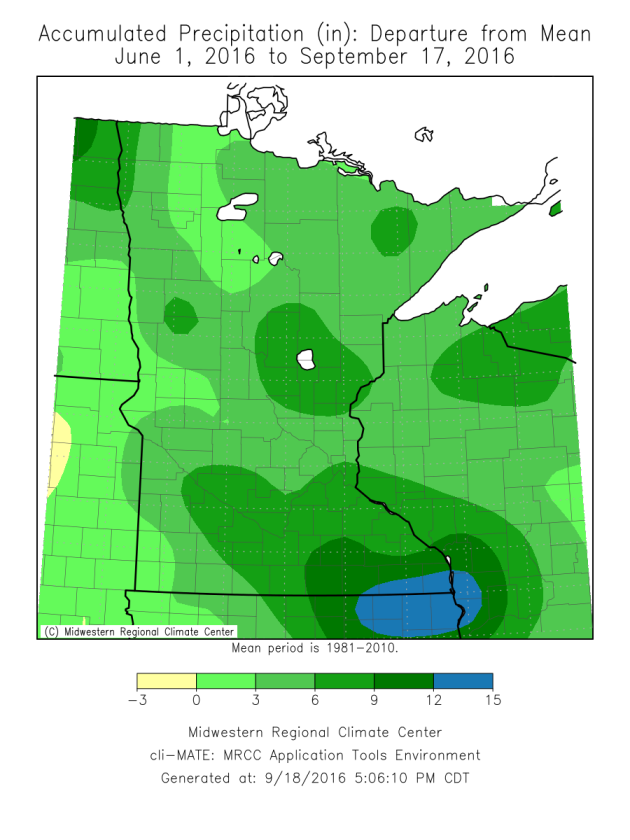
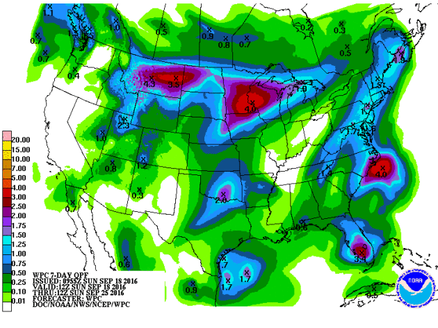
Extreme
drought is setting in across parts of New England, while here at home
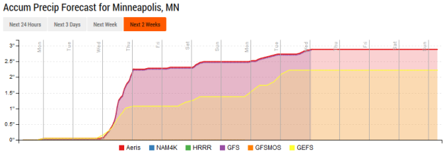
the monsoon rains just won't quit. Another 2-3 inches of rain may fall
between Wednesday and Sunday of next week. A warm frontal boundary sparks heavy T-storms Wednesday; a second frontal boundary temporarily stalls over Minnesota next weekend, prolonging prodigious puddles.
We finally dry out and cool off next week. No frost or flurries thru the end of September.
Or is it still June? The atmosphere remains very confused.
_______________________________________________

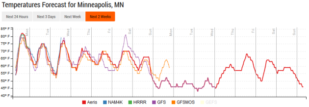
Extended Forecast for Minneapolis
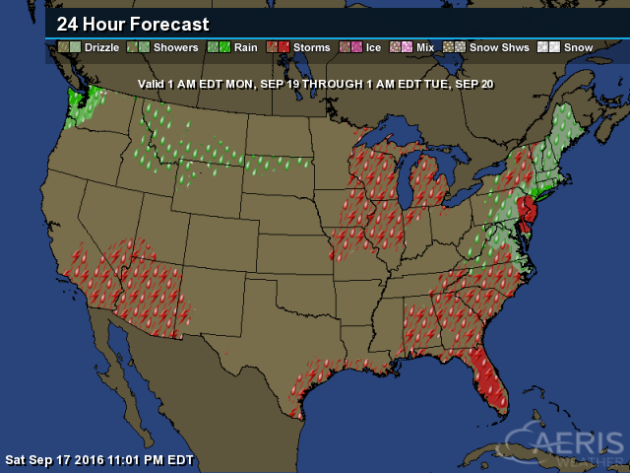
TUESDAY: Patchy clouds, stray PM shower. High 78. Low 63. Chance of rain 30%. Wind S 3-8 mph.
WEDNESDAY: T-storms, locally heavy rain. High 80. Low 61. Chance of rain 70%. Wind S 10-15 mph.
THURSDAY: Showers taper, gradual clearing. High 70. Low 58. Chance of rain 30%. Wind NE 8-13 mph.
FRIDAY: Dry start, more T-storms arrive late. High 73. Low 59. Chance of rain 60%. Wind E 10-15 mph.
SATURDAY: Sticky with T-storms, some heavy. High 76. Low 57. Chance of rain 70%. Wind SE 10-20 mph.
SUNDAY: Front stalls, more heavy T-storms. High 69. Low 55. Chance of rain 80%. Wind W 10-15 mph.
_______________________________________________
This Day in Weather History
September 19th
1998:
1 to 1 3/4 inch hail falls in Meeker, Wright, Todd, and Wilkin
Counties. Winds were also estimated over 50 knots / 58 miles per hour.September 19th
1980: Golfball to baseball sized hail hits St. Paul. One company has 75 to 95 percent of the glass in their greenhouses smashed.
_______________________________________________
Average Temperatures & Precipitation for Minneapolis
September 19th
September 19th
Average High: 70F (Record: 94F set in 1895)
Average Low: 51F (Record: 33F set in 1991)
Average Precipitation: 0.09" (Record: 2.98" set in 1907)
________________________________________________
Average Low: 51F (Record: 33F set in 1991)
Average Precipitation: 0.09" (Record: 2.98" set in 1907)
________________________________________________
Sunrise/Sunset Times for Minneapolis
September 19th
Sunrise: 6:57 AMSeptember 19th
Sunset: 7:15 PM
*Length Of Day: 12 hours, 18 minutes and 3 seconds
*Daylight Lost Since Yesterday: ~3 minutes and 6 seconds
*Next Sunrise That Is At/After 7 AM: September 21st (7:00 am)
*Next Sunset That Is Before 7 PM: September 28th (6:58 pm)
________________________________________________
Minnesota Weather Outlook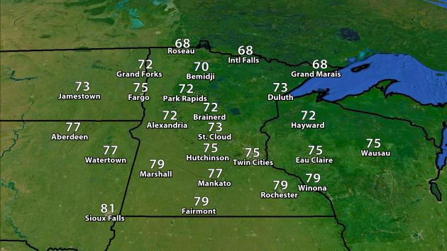
Highs will be a touch cooler Monday across the state behind a cold front, with mid 70s expected in the Twin Cities. Parts of northern Minnesota will be unlikely to get out of the 60s for highs once again.
________________________________________________
National Weather Stories
Storms
will be possible Monday along the East Coast and Gulf Coast along a
cold front. A second system will spark a storm chance across the Great
Lakes. Tropical moisture due to Paine in the Pacific will be surging
north, bringing a chance of storms to parts of the Southwest. A few
showers will be possible from South Dakota through Idaho, meanwhile a
weak front could bring some rain to the Pacific Northwest.
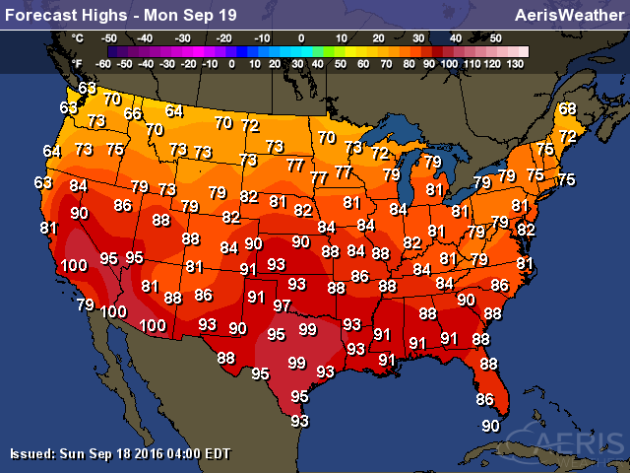
Highs will range from the 60s and 70s across the northern tier of states to the 90s and even some 100s across the south.
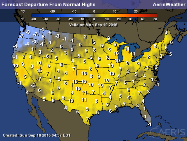
Highs
will once again be 5-10 degrees below average in parts of the Northwest
Monday. Some of the warmest weather (vs. average) will be from the
Southern Plains through the Great Lakes, with highs 5-15 degrees above
average.
iPhone 7 Has A Barometric Vent

Apparently
Apple has put a barometric vent in the new iPhones in the space where
the headphone jack used to be. What does that mean? More from The Verge: "Apparently
adding all the waterproofing to the iPhone 7 and 7 Plus meant that it
was more of a sealed box, and so to be able to have an accurate and
working barometer, Apple used that space. The barometer is the thing
that allows a phone to measure altitude, and Apple points out that on
the iPhone 7 it can measure even minor changes like climbing a flight of
stairs."
________________________________________________
Thanks for checking in and have a great Monday! Don't forget you can follow me on Twitter (@dkayserwx) or on Facebook (Meteorologist D.J. Kayser)!
- D.J. Kayser

No comments:
Post a Comment