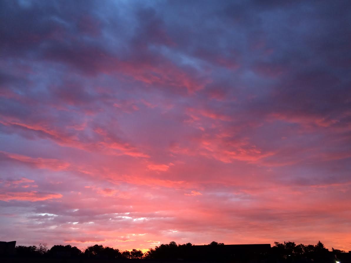
Sunrise Tuesday
This was the view of the sunrise on Tuesday as low clouds and light rain showers moved through the state. Much of Tuesday's rain fell during the early part of the day and across the central part of the state, so it actually turned out to be a pretty nice day!
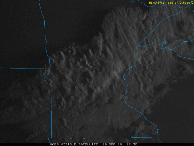
Sunny Tuesday
Here's a look at the cloud cover that brought areas of light rain to parts of Minnesota and Wisconsin on Tuesday morning. Note how quickly the clouds cleared out, which made for a very mild and pleasant afternoon.
Fall Color Continues
Slowly, but surely fall color is beginning to pop around the region. More widespread color will begin showing up within the next few weeks as cooler temps and dwindling daylight continues.

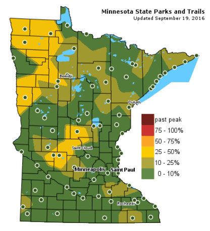
Fall Color Update
According to the MN DNR, we are well on our way in the fall color department with some 25%-50% color being reported across parts of Central and Northwestern Minnesota. Keep in mind that the average peak for the Twin Cities is generally late September to mid October.
___________________________________________________
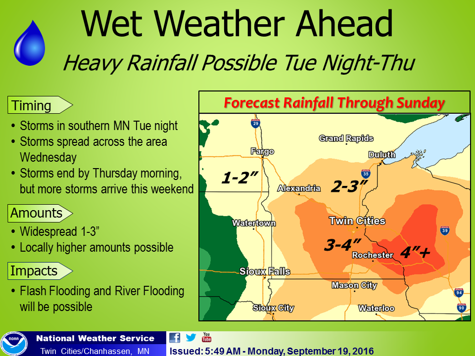
Heavy Rains on the Way...
"A few showers and thunderstorms will be scattered across the region Wednesday night and Thursday. Dry weather will follow into early next week. At this time there is a small chance for thunderstorms on Independence Day."
Heavy rain/flooding potential Tuesday night through early Thursday
"Between Tuesday night and Thursday morning, a widespread 1-3 inches of rain is expected across much of the area, with some areas seeing 3-5 inches.There could also be locally higher amounts.
Given saturated soil conditions, this excessive rainfall could lead to flooding"
Given saturated soil conditions, this excessive rainfall could lead to flooding"
"Timing: Tuesday evening into Wednesday morning: Round ONE of thunderstorms as a warm front lifts north across the area Wednesday into Thursday morning: Round TWO. This has potential to be the more significant round."
"Uncertainty: Moderate to high confidence that this pattern will generate heavy rainfall across central/southern MN and western WI"
"This pattern could generate rainfall amounts in excess of 6+ inches, but confidence regarding where the highest rainfall axis will set up is low at this point. The Wednesday & Wednesday night timeframe looks similar to the weather pattern of September 22nd-23rd, 2010 event; this event has the potential to draw in tropical moisture from Hurricane Paine as it dissipates over the southwestern U.S."
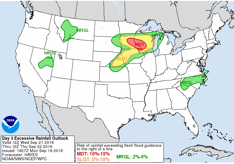
MODERATE Risk of Flash Flooding
According to NOAA's WPC, the Excessive Rainfall Outlook from AM Wednesday to AM Thursday suggests that there is a MODERATE risk or 10% to 15% risk of rainfall exceeding flash flood guidance from near the Twin Cities to western Wisconsin.
__________________________________________________
Flash Flood Potential Tuesday Night into Early Thursday
That hammering sound off in the distance is me, building an ark. It'll be a nice ark, complete with flush toilets, Wi-Fi, big-screen TV and a 50 year supply of SPAM. This requires a serious Costco run.
You may be sick of hearing about it but reality has a way of sneaking up and smacking you upside the head. Weather and climate are flip-sides of the same coin. Warmer air holds more water vapor; more high-octane fuel for storms. Basic physics.
NOAA scientists say climate change made recent historic flooding in Louisiana (up to 31 inches from a storm with no name) at least 40 percent more likely, but probably doubled the odds.
Just when you thought it couldn't get wetter here. Storms bubbling up along a stalled front wring out another 1-3 inches of rain tonight into early Thursday. A few towns could see considerably more - and urban and river flooding can't be ruled out.
NOAA models hint at drier, cooler weather next week as jet stream winds blow from the northwest.
All this warm wet weather in late September may delay peak fall color in the metro area until mid-October.
___________________________________________________
___________________________________________________
Extended Weather Outlook
MONDAY NIGHT: Clear and quiet. Wind: WSW 5. Low: 56.
TUESDAY: Warm sun early. Clouds thicken with storms late. Wind: S 7-12. High: 80
TUESDAY NIGHT: Mostly cloudy with thundershowers likely. Wind: ESE 5. Low: 62.
WEDNESDAY: T-storms with locally heavy rain. Wind: E 7-12. High: 72.
THURSDAY: Wet start, sun tries to peek thru. Wind: NE 8-13. Wake-up: 60. High: 74.
FRIDAY: Another round of showers and t-storm. Wind: E 10-15. Wake-up: 58. High: 70
SATURDAY: Sticky sun, feels like August. Winds: SE 10-15. Wake-up: 61. High: 80
SUNDAY: Showery rains, turning cooler. Winds: NW 10-20. Wake-up: 62. High: 71.
MONDAY: More clouds than sun. Drying out. Winds: NW 10-15. Wake-up: 58. High: 69.
_______________________________
_______________________________
This Day in Weather History
September 20th
September 20th
2001: 3/4 to 1 3/4 inch hail falls in Freeborn and Faribault counties.
1972: A downpour in Duluth produces 5 1/2 inches in ten hours.
________________________________
________________________________
Average High/Low for Minneapolis
September 20th
September 20th
Average High: 70F (Record: 91F set in 1931)
Average Low: 50F (Record: 28F set in 1962)
_________________________________
Average Low: 50F (Record: 28F set in 1962)
_________________________________
Sunrise/Sunset Times for Minneapolis
September 20th
September 20th
Sunrise: 6:58am
Sunset: 7:13pm
Sunset: 7:13pm
*Daylight Lost Since Yesterday: ~3mins & 6sec
*Daylight Lost Since Summer Solstice: ~3hours and 23mins
__________________________________
*Daylight Lost Since Summer Solstice: ~3hours and 23mins
__________________________________
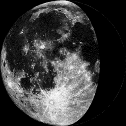
Moon Phase for September 20th
2.1 Days Before Last Quarter
2.1 Days Before Last Quarter
___________________________________
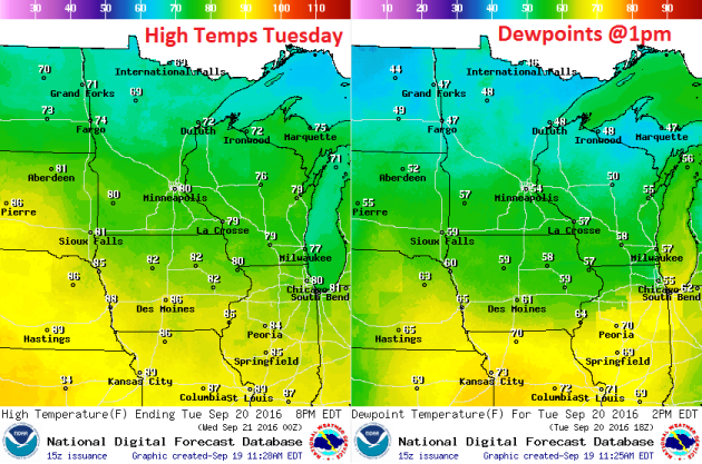
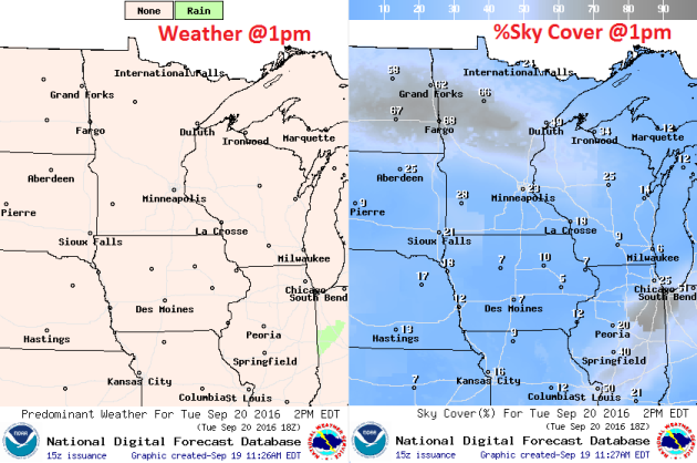
Weather Outlook Tuesday
Thanks to a warm front lifting into the region, high temperatures on Tuesday will rain from the upper 60s across the northern part of the state to the lower 80s across the southern part of the state. Dewpoints won't be too dramatic, but a few locations across southern Minnesota could see readings close to 60F.
Weather Outlook Tuesday
Winds on Tuesday won't be too much of an issue, but there could be a few gusts near 20mph across the far southwestern part of the state by the afternoon.
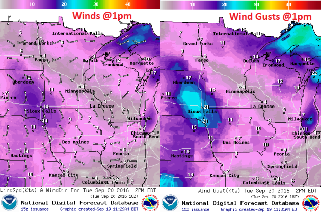
Weather Outlook Tuesday
Much of the day Tuesday will be dry, but a warm front lifting into the region will allow showers and storms to develop across the southern half of the state late in the day. These storms will lift northeast into central Minnesota and Wisconsin and could produce heavy rainfall, which may lead to flooding.
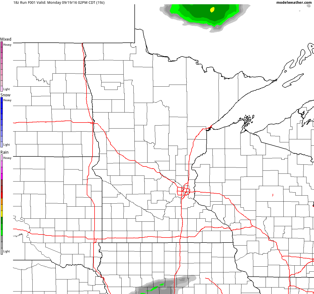
Simulated Radar
The simulated radar from PM Monday to Thursday suggests quiet weather as we start our Tuesday, but a round of heavy rainfall looks to develop along a warm front late Tuesday into Wednesday. Some of the storms could produce heavy rainfall.
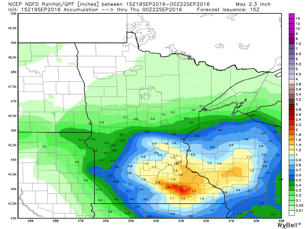
Rainfall Potential
Rainfall potential through PM Wednesday looks fairly heavy across parts of southern Minnesota and central Wisconsin with some 1" to near 2"+ amounts. Some locations could see locally heavier tallies if training thunderstorms linger over some areas for an extended amount of time.
__________________________________________
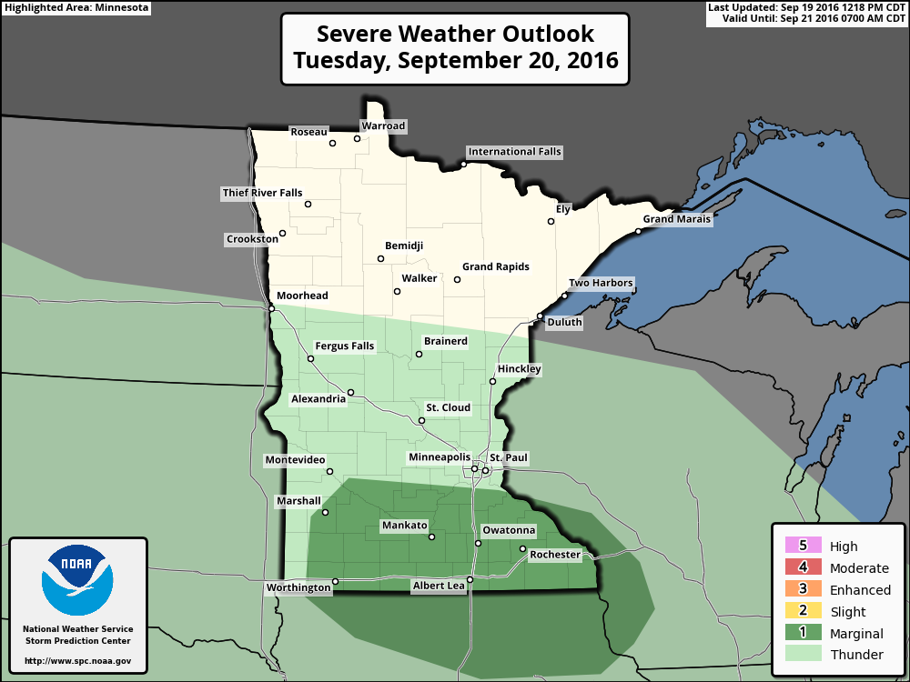
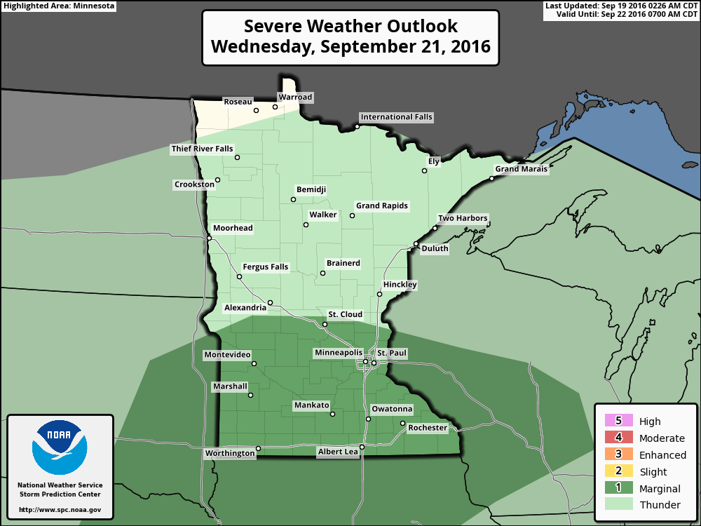
Severe Threat Tuesday
...SRN MN...NRN IA...FAR SW WI... COLD FRONT CURRENTLY DRAPED ACROSS THE REGION IS EXPECTED TO CONTINUE SEWD BUT MOISTURE IS EXPECTED TO RETURN QUICKLY IN ITS WAKE ON TUESDAY. CONSENSUS AMONGST THE GUIDANCE IS FOR DEWPOINTS TO BE ABOVE 65 DEG F ACROSS MUCH OF IA BY 21Z. HOWEVER...WARM TEMPERATURES ALOFT WILL BE ADVECTED INTO THE REGION /AROUND 20 DEG C AT 850 MB BY 21Z/...LIKELY KEEPING THE WARM SECTOR CAPPED AND FREE OF CONVECTION...PARTICULARLY GIVEN THE LACK OF LARGE SCALE FORCING FOR ASCENT. STEEP MID-LEVEL LAPSE RATES AND AMPLE SHEAR EXIST FOR SVR STORMS IF A STORM WAS ABLE TO FORM BUT THE PROSPECT OF ANY SURFACE-BASED DEVELOPMENT DURING THE AFTERNOON IS LOW. TSTMS ARE ANTICIPATED DURING THE EVENING AND OVERNIGHT AS A STRENGTHENING LOW-LEVEL JET ENCOURAGES ISENTROPIC ASCENT ALONG THE WARM FRONT. FORECAST SOUNDINGS SUGGEST STORM BASES AROUND 850 MB WITH STEEP MID-LEVEL LAPSE RATES REMAINING IN PLACE. AS SUCH...SUFFICIENT ELEVATED INSTABILITY WILL EXIST FOR STRONG UPDRAFTS. ADDITIONALLY...AMPLE VERTICAL SHEAR -- I.E. EFFECTIVE BULK SHEAR AROUND 40 KT -- WILL EXIST FOR UPDRAFT ROTATION/STORM ORGANIZATION. AS A RESULT...A FEW ELEVATED SUPERCELLS ARE POSSIBLE WITH A PRIMARY SVR THREAT OF LARGE HAIL. QUESTIONS REGARDING SVR COVERAGE AND STORM EVOLUTION -- I.E. IF THE TRANSITION TO MORE OF LINEAR/MCS MODE OCCURS -- PRECLUDES INTRODUCING 15-PERCENT PROBABILITIES WITH THIS FORECAST.
Severe Threat Wednesday
...PARTS OF THE CNTRL PLAINS/MID-MO VALLEY INTO THE UPPER MS VALLEY... RICH MOISTURE WILL BE IN PLACE FROM THE CNTRL PLAINS EWD INTO THE UPPER MS VALLEY AT THE START OF THE PERIOD S OF A QUASI-STATIONARY FRONT ORIENTED W-E ACROSS MN INTO NRN WI. EARLY CONVECTION WILL LIKELY BE OCCURRING TO THE N OF THIS BOUNDARY AS THE LLJ REMAINS FOCUSED ACROSS IA INTO SRN MN THROUGHOUT MOST OF THE DAY. MEANWHILE...A SHORTWAVE IMPULSE MOVING NEWD ACROSS THE CNTRL PLAINS SHOULD AID IN DEVELOPING ADDITIONAL CONVECTION ALONG A COLD FRONT S OF A WEAK SFC LOW OVER NERN NEB. A PLUME OF STEEP LAPSE RATES ALOFT WILL SUPPORT A VERY UNSTABLE AIR MASS...WITH MLCAPE VALUES FORECAST TO EXCEED 3000 J/KG IN MANY AREAS. ONE POTENTIAL LIMITING FACTOR IS A WEAKNESS WITHIN THE MID-UPPER LEVEL WINDS...WITH EFFECTIVE-LAYER SHEAR VALUES ONLY EXPECTED TO RANGE FROM 20-30 KT. TIMING OF CONVECTIVE INITIATION MAY ALSO BE DELAYED ALONG/AHEAD OF THE COLD FRONT INTO NEB/WRN IA UNTIL AFTER 22/00Z. GIVEN THESE FACTORS...AND THE POTENTIAL FOR EARLY CONVECTION N OF THE QUASI-STATIONARY FRONT TO AFFECT DETAILS OF THE MESOSCALE SETUP...A SLIGHT RISK WILL NOT BE INTRODUCED IN THIS OUTLOOK.
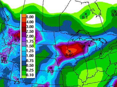
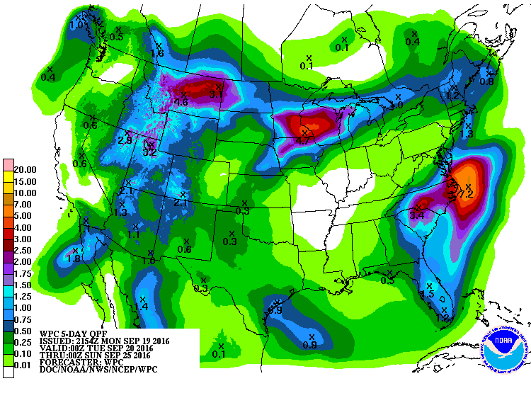
7 Day Rainfall Outlook
According to NOAA's HPC, the 7 day rainfall forecast through next Monday suggests some widespread 2" to 4" amounts with up to 5" possible in spots. This will come by way of 2 rounds of potentially heavy rainfall from PM Tuesday into AM Wednesday and another Wednesday into Thursday. Areas of heavy rain could lead to localized flooding.
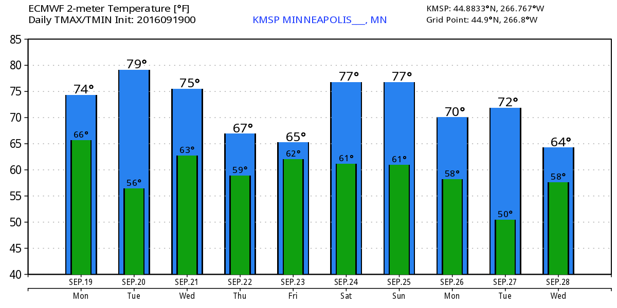
Extended Weather Outlook
The extended temperature outlook over the next 10 days suggests warmer than average temperatures hanging on through the middle part of the week before cooler temps arrive late week. It appears that warmer temperatures arrive by next weekend with highs back in the mid/upper 70s.
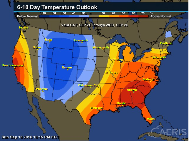
6 to 10 Day Temp Outlook
According to NOAA's Climate Prediction Center, there are equal chances of above and below normal temperatures from September 24th to the 28th. The warmer than average weather looks to be moving east, while cooler than average temperatures look to be settling into the Dakotas. Some of this cooler than average weather may be heading into our neck of the woods towards the end of the month.
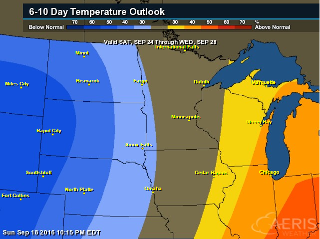
6 to 10 Day Temp Outlook
Here's the national temperature outlook from September 24th to th 28th, which shows the eastern half of the country still warmer than average, but note the big blob of cooler than average weather moving in across the Intermountain West.
__________________________________________
National Weather Outlook
Take a look at the national weather loop below. Note the heavy rain that looks to develop across the Midwest, which looks to begin late Tuesday into AM Wednesday and then another surge from Wednesday into Thursday. This heavy rainfall could lead to areas of flooding! Also note the heavier rainfall that looks to show up across the Southwest midweek. This moisture is linked to PAINE, a tropical system in the Eastern Pacific.

Precipitation Outlook
According to NOAA's WPC, the 5 day precipitation forecast shows pockets of heavy rain from the Mid-Atlantic to the Midwest and parts of the Intermountain West. Some of these heavier pockets of rain could lead to areas of flooding.
__________________________________________
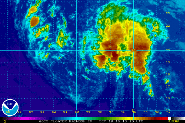
KARL
This was the view of Tropical Storm Karl from Monday evening, which showed a little more organization from earlier in day. Additional strengthening is expected over the next few days and could become a hurricane by the end of the week. The good news is that Karl should steer away from the Lower 48, but could impact Bermuda by the weekend.
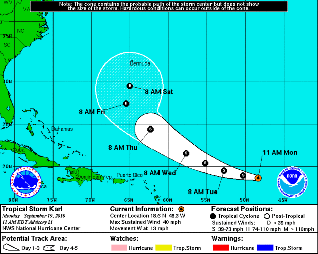
Tracking KARL
According to NOAA's NHC, Karl is expected to steer clear of the Lower 48, but will likely move closer to Bermuda by the weekend with potentially greater impacts.
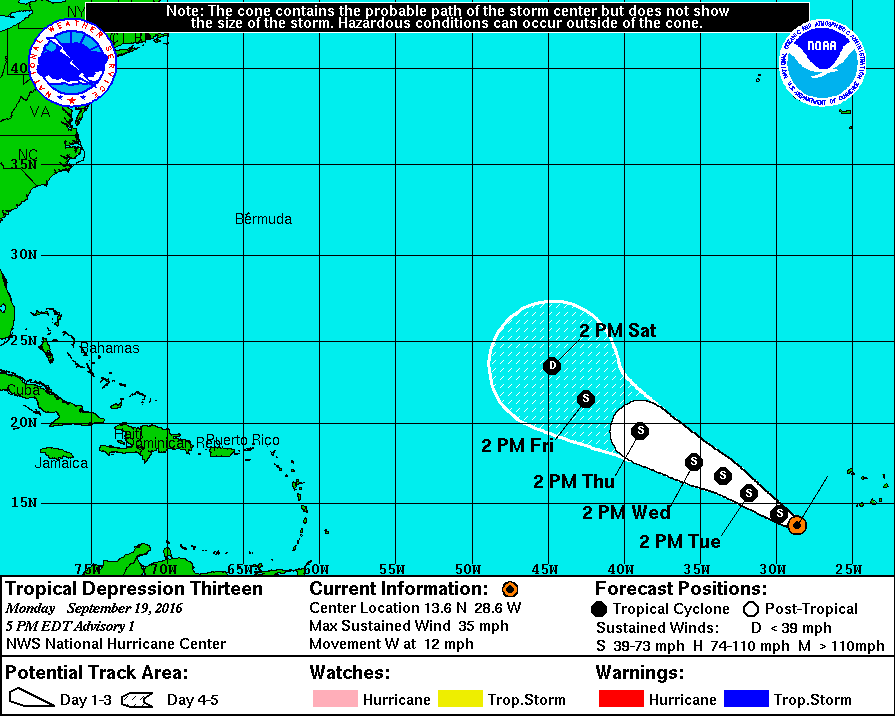
Tropical Depression THIRTEEN
This particular storm is likely to become LISA this week as it lifts northwest. At this point, this storm should pose no threat to the U.S.
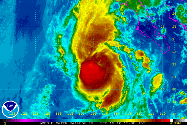
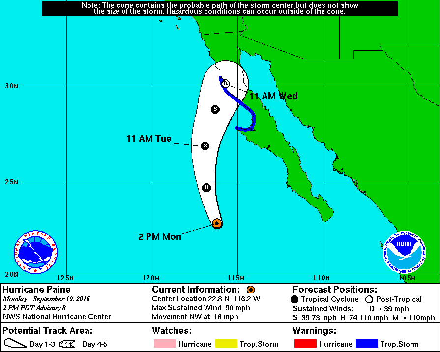
Paine in the Eastern Pacific
PAINE continues in the Eastern Pacific, but will diminish to tropical storm status as early as Tuesday. Note that this storm is heading north and will likely bring heavier rain to parts of the Southwestern U.S. by midweek.
Tracking Paine
According to NOAA's NHC, PAINE will continue to diminish in intensity as it lifts north toward Baja California.
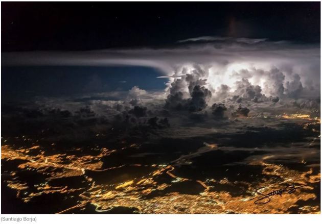
"This incredible thunderstorm photo was taken from a plane over Panama City"
"A thunderstorm exploded over Panama City last week. Towering cumulonimbus climb high around its core. An anvil cloud stretches out at the top of the troposphere, swept downwind by the jet stream. There’s a faint hint of an over-shooting top above the core, which indicates the storm’s updraft is so strong, it’s penetrating the super-stable stratosphere. The city lights are blurred, but the storm is in focus. A few stars are faintly visible. The photo was shot by Santiago Borja from the cockpit of a plane at the precise moment of a lightning flash, which illuminates the storm. It isn’t the first time he’s captured such a remarkable image."
See more from WashingtonPost.com HERE:
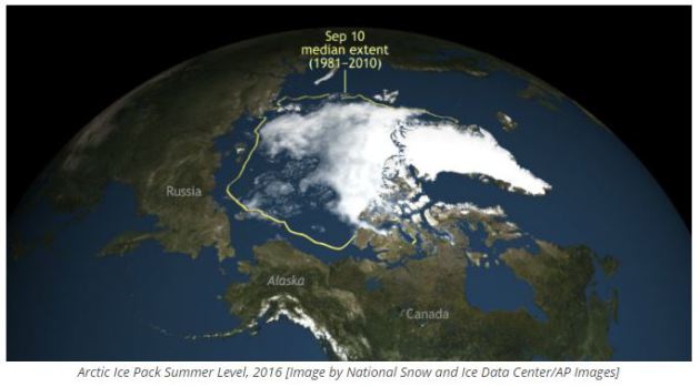
______________________________________"Arctic Ice Packing Melting at Record Levels at Climate Change Takes Hold"
"Arctic ice pack levels have receded to the second lowest level ever recorded in an ominous sign of global climate change. The Arctic ice pack, or the amount of solid ice that has formed in the Arctic Circle, fluctuates in size with the seasons. The summer low point this year was the second lowest recorded in history, exceeded only by the record low of 2012. Below, you can watch a NASA video of the Arctic ice pack at its minimum extent last year, which was the fourth lowest on record. Arctic ice is monitored by The National Snow and Ice Data Center in Colorado, who told the Guardian that the ice pack reached a mark of 1.6 million square miles, a record low and vastly less than the averages established between 1970 and 2000. Mark Serreze, director of the Center, said that the new low in Arctic ice confirms a frightening new reality."
See more from the Inquisitr.com HERE:
__________________________________________"This Map Shows How Climate Change May Force Animals To Find New Homes"
"By the middle of the century, the Baltimore oriole may no longer live in Maryland. And the brown pelican—the state bird of Louisiana—may no longer live in Louisiana. Thousands of other species are also likely to move as they try to adapt to a climate change. A new map from the Nature Conservancy shows that migration on a massive scale, based on a 2013 study that projected the movement of 2,903 mammals, birds, and amphibians in the Western Hemisphere."
See more from FastCoexist.com HERE:

_____________________________________
Thanks for checking in and have a great end of the week and weekend ahead!
Don't forget to follow me on Twitter @TNelsonWX
Don't forget to follow me on Twitter @TNelsonWX

No comments:
Post a Comment