Northern Lights Potential
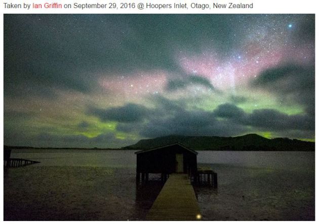
"SOLAR WIND STORM: Four days ago, Earth entered a fast-moving stream of solar wind. We're still inside. On Sept. 30th, the solar wind is clocking speeds in excess of 650 km/s (1.5 million mph) with little sign of slackening. This is putting pressure on Earth's magnetic field and sparking auroras around the poles. Ian Griffin photographed the colorful glow last night from Otago, New Zealand. "A beautiful pastel aurora daubed the sky above Hoopers Inlet on the Otago Peninsula on Sept. 29th," says Griffin. "Despite clouds, the view was absolutely sublime." More auroras are possible tonight. NOAA forecasters estimate a 35% chance ofG1-class geomagnetic storms on Sept. 30th as the solar wind continues to blow."
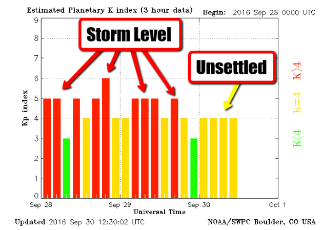
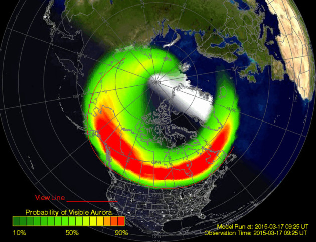
Here's a product that helps to describe how active the northern lights may be. Note that when the Planetary K-index reaches 5 or higher, we typically are able to see the northern lights from our latitude in Minnesota and Wisconsin. Note that this index has been at storm levels since Wednesday!
Weekend Northern Lights Forecast
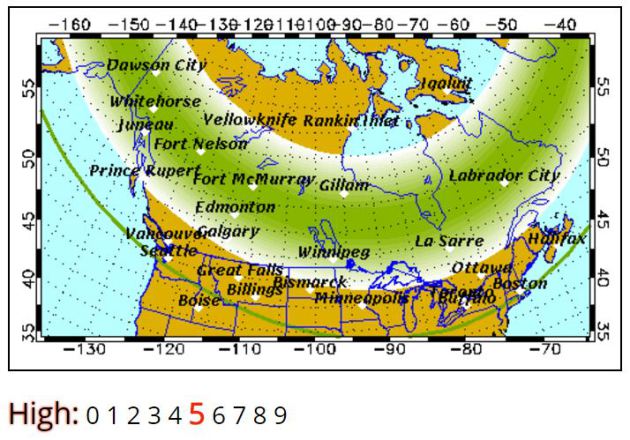
The geomagnetic storm that occurred on the sun earlier this week will continue to buffet Earth through the weekend. At this point, there is still a fairly decent chance at seeing northern lights as long as skies clear. Take a look at the weekend northern lights forecast from the Geophysical Institute at the University of Alaska Fairbanks.
"Forecast: Auroral activity will be high(+). Weather permitting, highly active auroral displays will be visible overhead from Inuvik, Yellowknife, Rankin and Igaluit to Vancouver, Helena, Minneapolis, Milwaukee, Bay City, Toronto, Montpelier, and Charlottetown, and visible low on the horizon from Salem, Boise, Cheyenne, Lincoln, Indianapolis and Annapolis."
Northern Lights
Here are a couple of other bookmark worthy northern lights website that will help you stay current with what's happening. The first is SpaceWeatherLive.com that shows the current aurora and the probability of seeing northern lights (weather permitting). The next is SoftServeNews.com
Hurricane Matthew
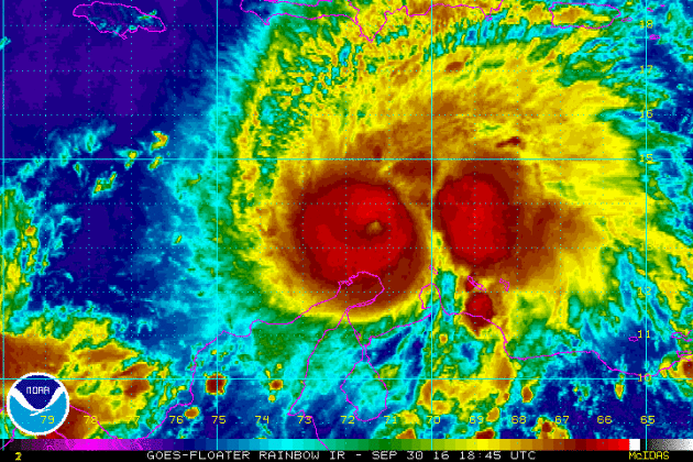
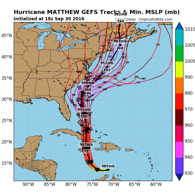
Hurricane Matthew became the 5th hurricane of the 2016 Atlantic hurricane season on Thursday and strengthened rapidly into a MAJOR category 3 hurricane Friday morning. As of PM Friday, Matthew was a category 4 hurricane with sustained winds up to 150mph. Matthew is located in the Caribbean and is expected to lift straight north this weekend toward Cuba and the Bahamas by early next week.
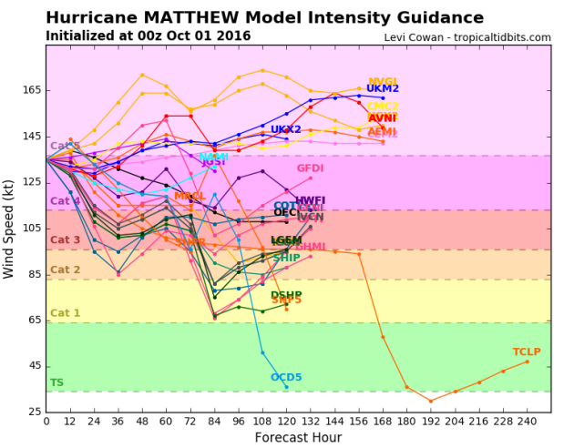
Model guidance suggests that that Matthew will possibly strengthen into a category 5 and or stay at category 4 strength before diminishing over the next few days. This is a very strong storm!
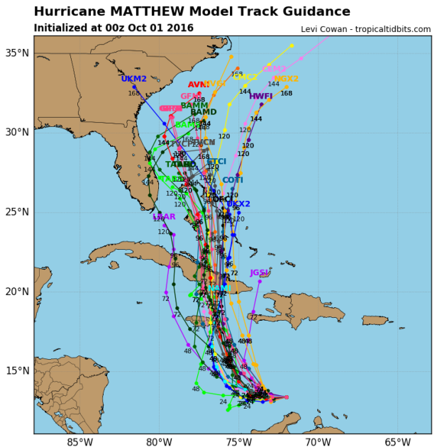
Tracking Matthew
The official track from the National Hurricane Center suggests Matthew will continue at major hurricane strength through early next week as it makes a close encounter with Jamaica and slides over western Cuba. Note that the the northerly track takes it over the Bahamas by the middle part of next week as a hurricane.
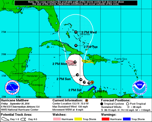
Here are a few different model solutions for Matthew. Note that most are pretty consistent as it tracks over eastern Cuba and the Bahamas early next week. The extended forecast for mid/late week gets a little hairy as some track the system into the Eastern U.S., while others take it out into the Atlantic Ocean.
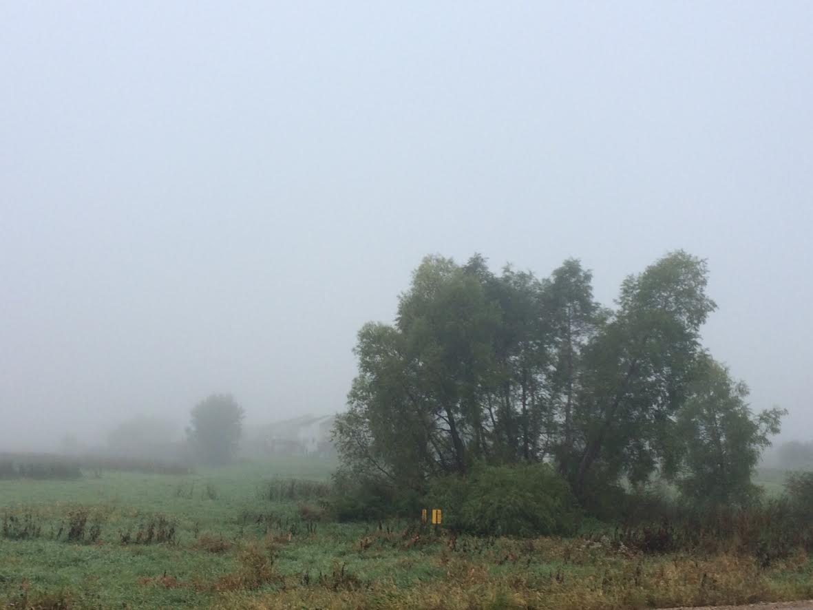
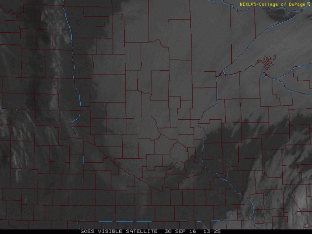
After a sunnier Thursday, most of us woke up to fog on Friday. Note that there the eastern side of the metro and into western Wisconsin woke up to sunshine, but not so much across the rest of the metro.
Signs of Fall Closer to Home
Charles A. Lindbergh State Park - Randy Keillor

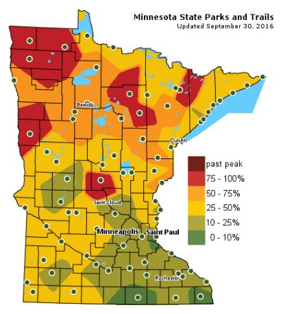
Fall Color Update
The latest update from the MN DNR shows that we are well on our way in the fall color department with some peak colors (75% - 100%) color being reported across parts of Central and Northwestern Minnesota. Note that only 10% to 25% color can be found across the Twin Cities; the average peak there is generally late September to mid October.
___________________________________________
Cloudy, but dry Saturday. September-like Sunday
USA! USA! USA!
Thunderous roars from the gallery at Hazeltine can be heard for miles. I am happy to report that weather conditions through the rest of the weekend will remain dry with high temperatures flirting with 70 degrees both Saturday and Sunday.
Note that the same stubborn storm system that brought us gusty winds and scattered showers earlier this week will once again plague us with more clouds today. The slow moving storm will finally drift east enough for gradually clearing skies on Sunday.
An approaching storm system will increase winds and temperatures early next week with highs in the mid 70s. Scattered showers and a few storms arrive midweek with temperatures plummeting late next week as the storm scoots east. I wouldn't be surprised to see more frost and freeze concerns up north late next week.
Meanwhile, hurricane Matthew strengthened into a major, category 3 storm on Friday with winds approaching 120mph in the Caribbean. Forecast to track over Cuba, through the Bahamas and close to the East Coast next week.
___________________________________________________
Extended Weather Outlook
FRIDAY NIGHT: Mostly cloudy. Winds: ENE 5. Low: 53
SATURDAY: Mostly cloudy, but a dry start to October. Winds: ENE 5-10. High: 67
SATURDAY NIGHT: Mostly cloudy. Winds: E 5. Low: 51.
SUNDAY: Clouds thin through the day. A touch warmer. Winds: ESE 5-10. High: 70
MONDAY: Mostly sunny and mild. More PM wind. Winds: SE 10-15. Wake-up: 52. High: 72
TUESDAY: Breezy. More PM clouds, storms overnight. Winds: SSE 15-25. Wake-up: 56. High: 72
WEDNESDAY: Breezy again. Scattered storms. Winds: S 15-25. Wake-up: 57. High: 67
THURSDAY: Chilly with a few wind-whipped showers. Winds: WSW 10-20. Wake-up: 50. High: 62.
FRIDAY: Low gray clouds. Jacket worth. Winds: NW 5-15. Wake-up: 50. High: 60.
_______________________________
_______________________________
This Day in Weather History
October 1st
1999: One of the earliest significant snowfalls in Minnesota history falls in a narrow track across southern Minnesota. Reported snowfall totals include 4.0 inches in Montgomery (Le Sueur County) and Northfield (Rice County), 3.8 inches in Springfield (Brown County), 3.0 inches in Vesta (Redwood county), and 2.8 inches in Mankato (Blue Earth County).October 1st
1989: High temperatures across central and southern Minnesota reach the 80's. Later in the day, a cold front would come through and drop the mercury to the 40's.
________________________________
Average High/Low for Minneapolis
October 1st
Average High: 65F (Record: 87F set in 1897)
Average Low: 45F (Record: 24F set in 1974)
_________________________________
Average Low: 45F (Record: 24F set in 1974)
_________________________________
Sunrise/Sunset Times for Minneapolis
October 1st
October 1st
Sunrise: 7:11am
Sunset: 6:52pm
Sunset: 6:52pm
*Daylight Lost Since Yesterday: ~3mins & 6sec
*Daylight Lost Since Summer Solstice: ~3hours and 52mins
______________________________________________________________________
*Daylight Lost Since Summer Solstice: ~3hours and 52mins
______________________________________________________________________
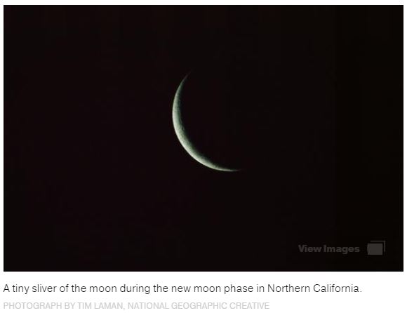
Moon Phase for October 1st at Midnight
1.3 Days After New Moon
1.3 Days After New Moon

_______________________________________________________________________
Black Moon Rises
"Humans have long had a fascination with lunar events—and with the rise of the Internet, all kinds of moon moments have become media sensations. Consider super moons, harvest moons, and the rare super blood moon total eclipse. On September 30, sky-watchers in the Western Hemisphere may be tempted to add another lunar moniker to the list: a “black moon,” popularly defined as the second new moon in a month. However, it’s not exactly going to make for good sky-watching. New moons occur when the moon’s orbit takes it between Earth and the sun, leaving the lunar orb’s unilluminated side facing Earth. At night, this phase of the moon is impossible to see: Since new moons are in the same part of the sky as the sun, they rise and set with the sun and are overwhelmed by its glare. New moons can be readily seen only when they pass directly in front of the sun, causing solar eclipses. Otherwise, sky-watchers must look to the days before or after a new moon, when just a sliver of the moon’s sunlit side is visible from Earth.".See more from NatGeo HERE:
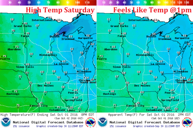
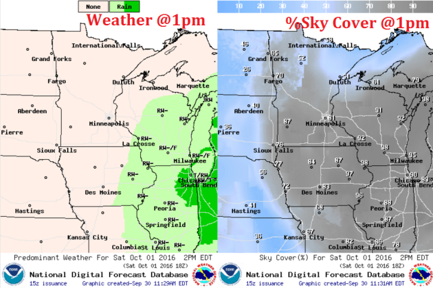
Weather Outlook Saturday
High temperatures on Saturday will be a little cooler across parts of the state due to a few more clouds drifting into the region for the same storm system that bothered us earlier this week. Some spots across western MN would still sneak up to 70F with a little more sunshine.
Weather Outlook Saturday
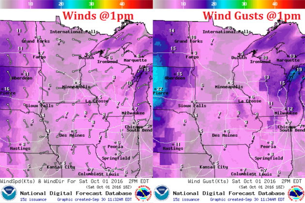
Winds will not be a problem on Saturday either as they blow from an easterly direction at 5-10mph.
Weather Outlook Saturday
The same stubborn storm system that brought us scattered showers and storms earlier this week settled into the Ohio Valley. It will begin lifting back north toward the Great Lakes this weekend, which means that additional clouds will push back into our neck of the woods both Saturday and Sunday. Note that rain chances will remain east of us, mainly across Wisconsin.
___________________________________________________________
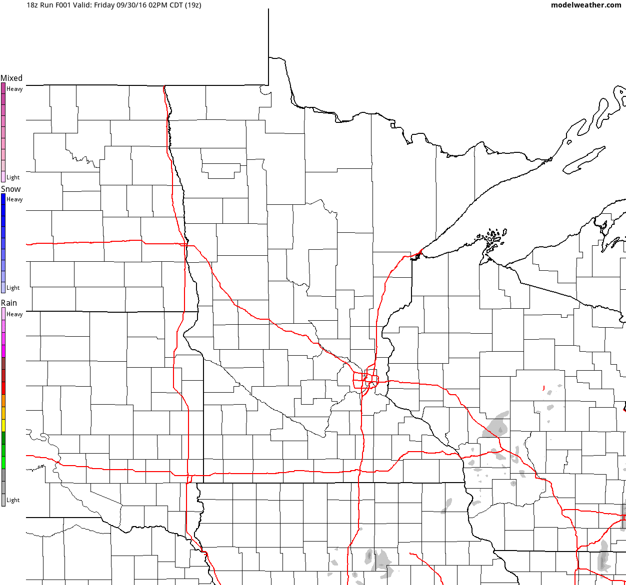
Simulated Radar
The simulated radar from Friday to Sunday shows mostly dry weather continuing across the region with only a few spotty showers possible closer to the Great Lakes.
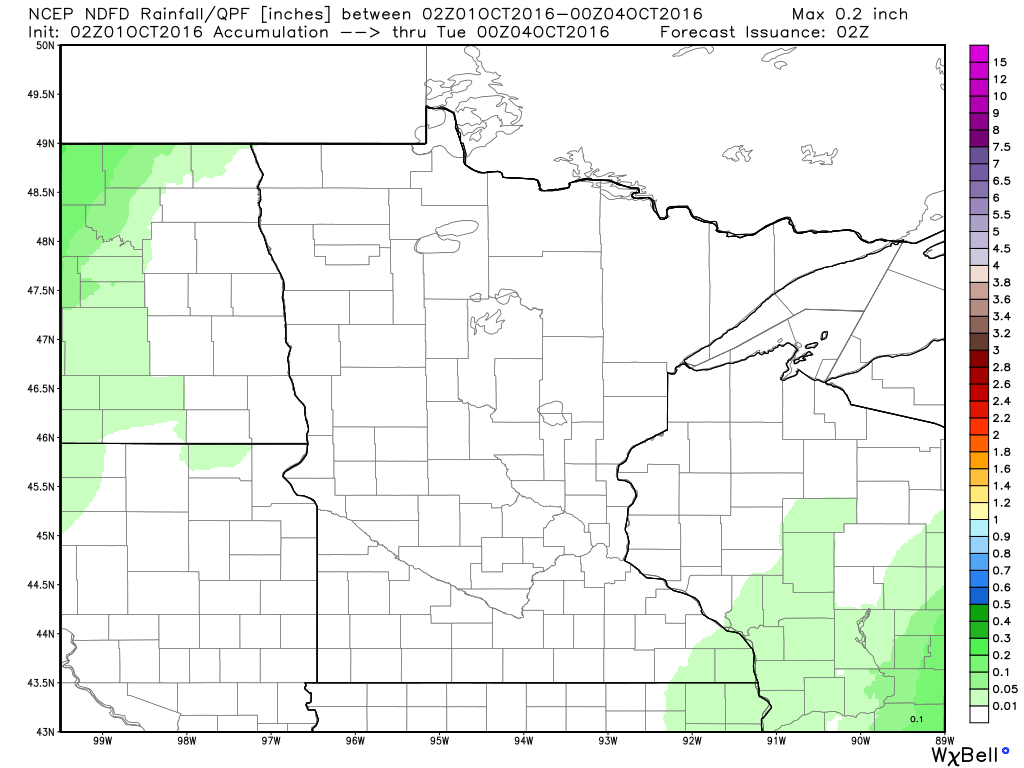
Rainfall Potential
Rainfall potential through PM Monday suggests a few light showers possible across the extreme southeastern Minnesota and central Wisconsin. Other than that, most locations will stay mostly dry through the weekend.
_________________________________________
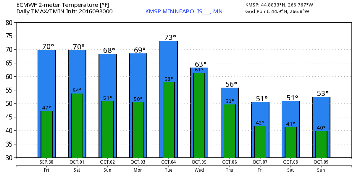
Extended Weather Outlook
The extended temperature outlook over the next 10 days suggests temperatures warming slowly over the next few days to near 70F over the weekend and early next week. There appears to be a quick jump into the mid 70s on Tuesday before a fairly significant cold front sweeps through by the end of next week. High temperatures by the second of October looks to be potentially very chilly.
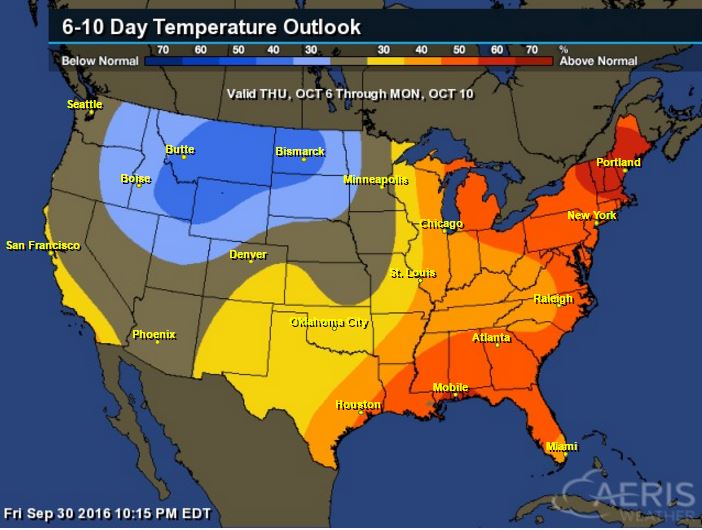
6 to 10 Day Temp Outlook
According to NOAA's Climate Prediction Center, warmer than average temperatures look to continue across the Great Lakes Region, but note the cooler than average temperatures lurking just to the west. This could potentially make for a chilly second weekend of October.
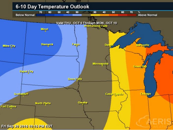
6 to 10 Day Temp Outlook
Here's the national temperature outlook from October 6th - 10th, which shows warmer than average conditions across the eastern half of the nation with cooler than average temperatures returning to places in the Intermountain-West
__________________________________________
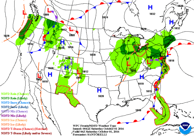
National Weather Outlook
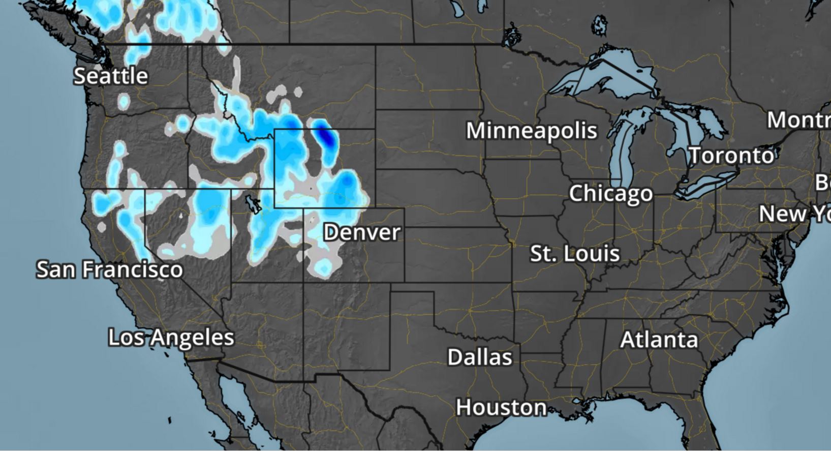
A stalled and slow moving area of low pressure over the Ohio Valley/Great Lakes Region will slowly move north/northeast over the weekend. Heavy rains will still be possible across parts of the northeastern U.S., while mostly dry weather looks to continue in the Central U.S.. Heavier, steadier rain looks to move in along the West Coast as a large storm system moves in. This will bring mountain snow back into the Western U.S. over the next 5 days.
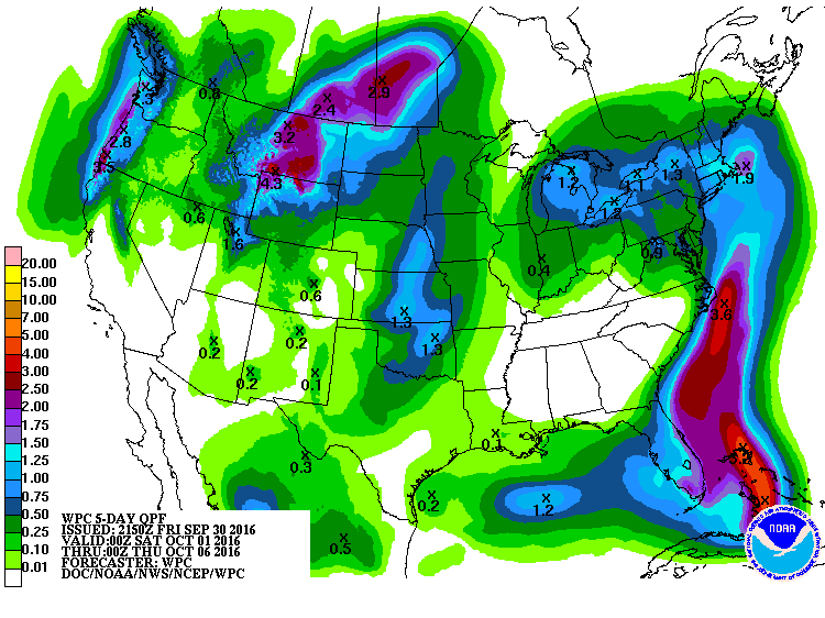
Precipitation Outlook
The heaviest rainfall over the next few days will be found in the Great Lakes Region and parts of the Northeast with some isolated flood concerns possible. There will also be some heavier rainfall tallies possible across the Intermountain West and along the West Coast.
 ___________________________________________
Western Storm System
The next storm system is forecast to move into the Western U.S. with some gusto by this weekend and early next week. Gusty winds, colder temps and high elevation snow will be possible. Interestingly, this storm will bring chances of widespread rain/thunder to the Upper Midwest by the middle part of next week.
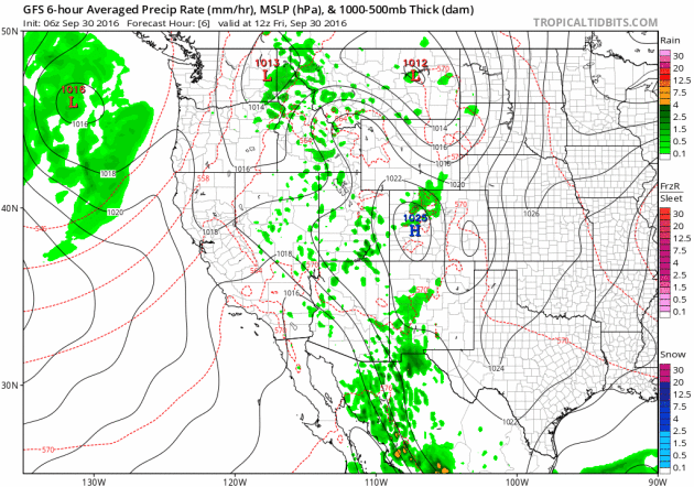
As the storm system works inland, moisture will turn to snow across the higher elevations from the Sierra Nevada Range to the Colorado Rockies. There may even be a little snow in the lower elevations along the Front Range.
______________________________________________
Colder Temps Late Next Week/Weekend
The same storm system that is expected bring snow to the Intermountain West will bring colder temperatures to the Upper Midwest by the end of the week and next weekend.
__________________________________________________
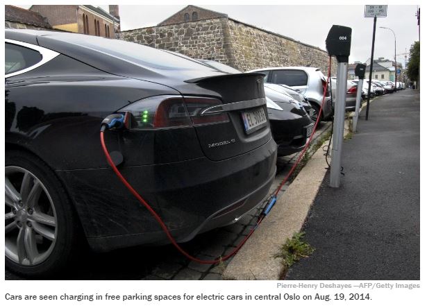
"Oslo Plans ‘Climate Budget’ to Cut Emissions in Half"
""We'll count carbon dioxide the same way as we count money" The city government in Oslo announced plans to prioritize greenhouse gas emissions with the creation of a “climate budget” that officials hope will help the city cut greenhouse gas emissions in half in just four years. “We’ll count carbon dioxide the same way as we count money,” said Vice Mayor Robert Steen, according to a Reuters report. Cities around the globe have introduced plans in recent years to reduce their greenhouse gas emissions, but Oslo’s plan leaves most others in the dust. The city will increase tolls for drivers who want to bring their cars into the city, remove parking spaces, reduce fossil fuel sources of heat in homes and switch the bus fleet to renewable fuel sources, among other things."
See more from Time.com HERE:
See more from Time.com HERE:
Thanks for checking in and don't forget to follow me on Twitter @TNelsonWX

No comments:
Post a Comment