Hurricane Matthew
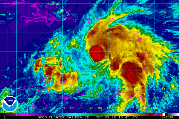
Hurricane Matthew became the 5th hurricane of the 2016 Atlantic hurricane season, which was located in the Caribbean on Thursday. Matthew will be an interesting storm as it intensifies and takes a hard right, lifting straight north this weekend.
Watching the Tropics
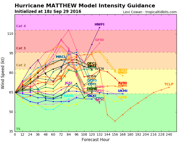
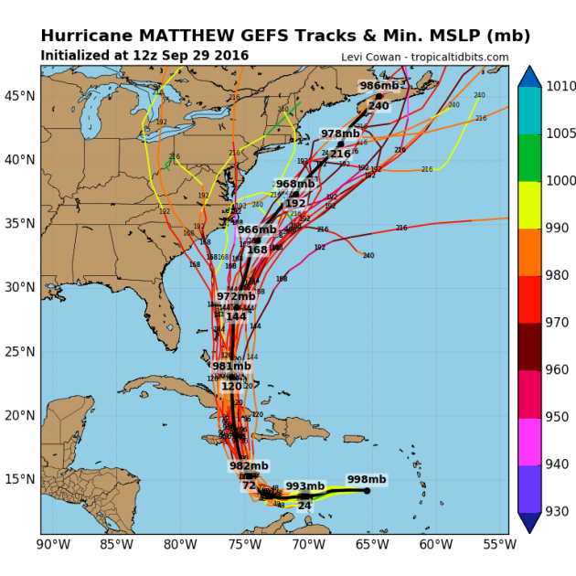
Model guidance suggests that that Matthew will possibly strengthen into a category 2, maybe even category 3 over the next few days. Regardless of what happens, latest trends suggest hurricane strength over the next few days.
Tracking the Tropics
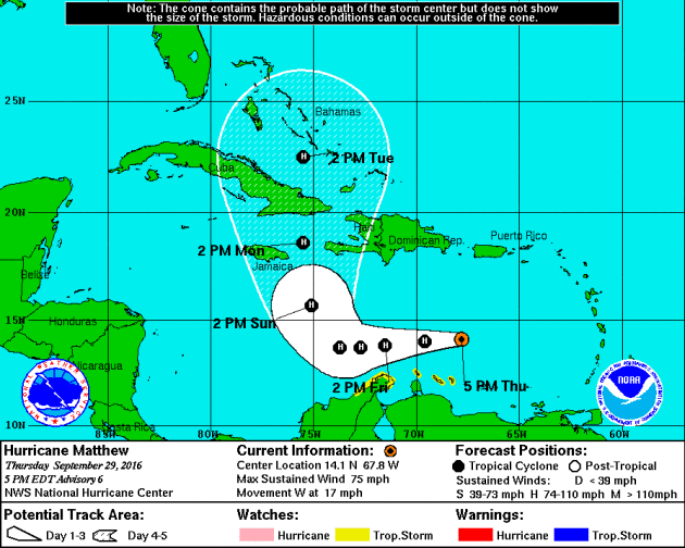
The official track from the National Hurricane Center suggests Matthew staying at hurricane status as is drifts north over Cuba and the Bahamas this weekend and early next week. Heavy rain and hurricane force wind gusts will be possible as this system tracks through the Caribbean.
Watching the Tropics
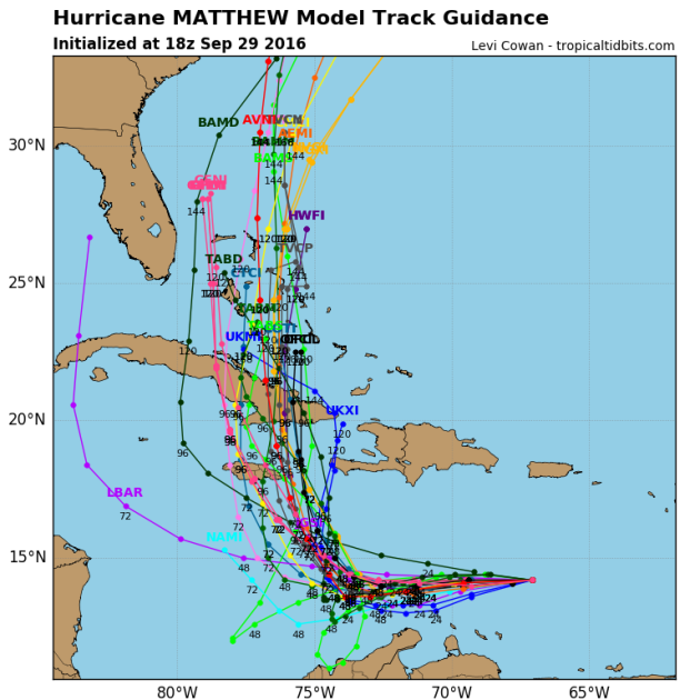
Here are a few different model solutions for Matthew. Note that most are pretty consistent as it tracks over western Cuba and the Bahamas this weekend and early next week. The extended forecast for mid/late week gets a little hairy as some track the system into the Eastern U.S., while others take it out into the Atlantic Ocean.
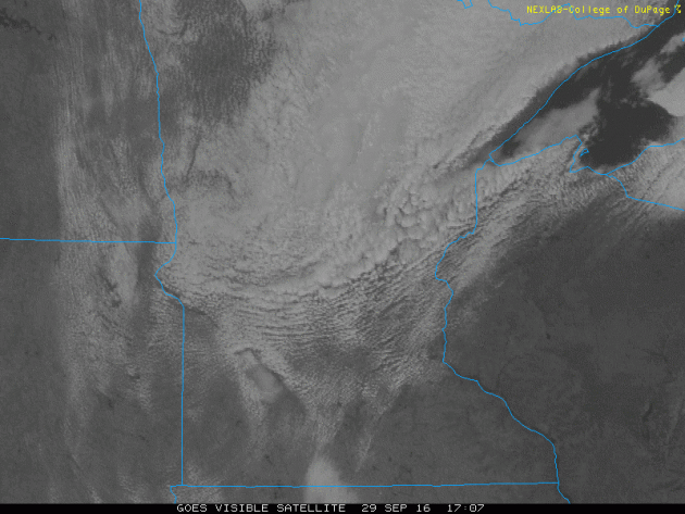
After several days of cool, windy and somewhat soggy weather, skies finally cleared Thursday. Here was the visible satellite loop from late Thursday as just a few clouds hung tight across the northern part of the state. Much of the Upper Midwest got back into sunshine, which looks to continue into some fashion Friday.
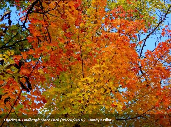
Signs of Fall Closer to Home
Charles A. Lindbergh State Park - Randy Keillor
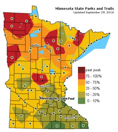
Fall Color Update
The latest update from the MN DNR shows that we are well on our way in the fall color department with some peak colors (75% - 100%) color being reported across parts of Central and Northwestern Minnesota. Note that only 10% to 25% color can be found across the Twin Cities; the average peak there is generally late September to mid October.
___________________________________________
Dry Ryder Cup FORE!-cast
The buzz around the Ryder cup is palpable. Folks have been flocking to Chaska by the thousands to see what some the world's greatest golfers will bring this weekend.
Minnesotans are making a big presence as our state boasts more golfers than any other state in the country. How about that.
Weather trends look good for the next 3 days. Whether you're golfing, leaf peeping or picking apples, dry weather looks to persist through early next week. The stubborn storm system that brought scattered showers and gusty winds early this week has stalled over the Ohio Valley for now. The pesky low begins wobbling north again this weekend, which will bring a few more clouds to neighborhoods near you Saturday and Sunday, though we'll continue to stay through Monday.
Most of next week looks warmer than average, but extended model runs are advertising a fairly potent storm system arriving late next week with scattered storms midweek. In the wake of the storm, a cold wind develops, which could bring another round of frost for folks up north.
___________________________________________________
Extended Weather Outlook
THURSDAY NIGHT: Mostly clear and cool. Some patchy fog possible. Winds: NNE 5. Low: 47
FRIDAY: Sunnier start, a few more PM clouds. Winds: E 5-10. High: 70
FRIDAY NIGHT: Mostly cloudy. Winds: ENE 5. Low: 52
SATURDAY: Partly sunny. Dry start to October. Winds: ESE 5-10. 52. High: 68
SUNDAY: Sun and cloud mix. Mild temps. Winds: SE 5-10. Wake-up: 52. High: 69
MONDAY: Partly cloudy, increasing winds. Winds: SE 10-15. Wake-up: 53. High: 70
TUESDAY: Breezy. Spotty storms possible late. Winds: SSE 15-25. Wake-up: 54. High: 72
WEDNESDAY: Mostly cloudy with scattered storms. Winds: SSW 10-15. Wake-up: 56. High: 68
THURSDAY: Chilly winds return. Showers taper late. Winds: NW 10-20. Wake-up: 51. High: 62.
_______________________________
_______________________________
This Day in Weather History
September 30th
1995: Lightning starts a house on fire in Washington County.September 30th
1985: 4 inches of snow falls in Ely, with just a trace in the Twin Cities.
________________________________
Average High/Low for Minneapolis
September 30th
Average High: 65F (Record: 87F set in 1897)
Average Low: 46F (Record: 26F set in 1939)
_________________________________
Average Low: 46F (Record: 26F set in 1939)
_________________________________
Sunrise/Sunset Times for Minneapolis
September 30th
September 30th
Sunrise: 7:10am
Sunset: 6:54pm
Sunset: 6:54pm
*Daylight Lost Since Yesterday: ~3mins & 6sec
*Daylight Lost Since Summer Solstice: ~3hours and 49mins
______________________________________________________________________
*Daylight Lost Since Summer Solstice: ~3hours and 49mins
______________________________________________________________________
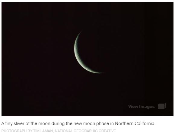
Moon Phase for September 30th at Midnight
0.3 Days After New Moon
0.3 Days After New Moon

_______________________________________________________________________
Black Moon Rises
"Humans have long had a fascination with lunar events—and with the rise of the Internet, all kinds of moon moments have become media sensations. Consider super moons, harvest moons, and the rare super blood moon total eclipse. On September 30, sky-watchers in the Western Hemisphere may be tempted to add another lunar moniker to the list: a “black moon,” popularly defined as the second new moon in a month. However, it’s not exactly going to make for good sky-watching. New moons occur when the moon’s orbit takes it between Earth and the sun, leaving the lunar orb’s unilluminated side facing Earth. At night, this phase of the moon is impossible to see: Since new moons are in the same part of the sky as the sun, they rise and set with the sun and are overwhelmed by its glare. New moons can be readily seen only when they pass directly in front of the sun, causing solar eclipses. Otherwise, sky-watchers must look to the days before or after a new moon, when just a sliver of the moon’s sunlit side is visible from Earth.".See more from NatGeo HERE:
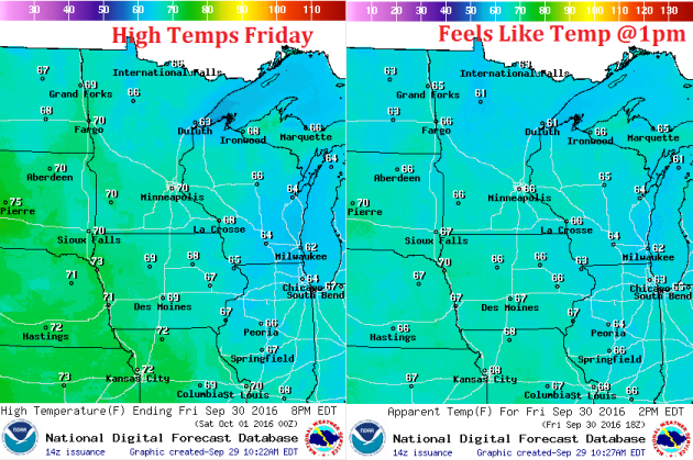
Weather Outlook Friday
High temperatures on Friday will approach 70F across much of the central and southern half the state. However, dry dewpoints and a light breeze will make it feel more like the mid/upper 60s for much of the day.
Weather Outlook Friday
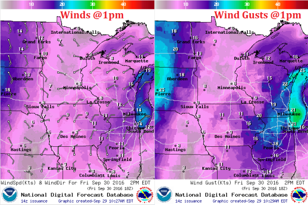
Winds certainly won't be an issue on Friday as they remain light out of the east. The storm system that produced wind conditions for us earlier this week will keep breezy conditions going across the Great Lakes Region Friday.
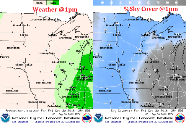
Weather Outlook Friday
The storm system that brought gusty winds and scattered rain showers to our neck of the woods early this week will be found across the Great Lakes and Ohio Valley on Friday. The storm system looks to wobble north toward the Great Lakes Region by the weekend, which may help to increase our cloud cover on Saturday and Sunday.
___________________________________________________________
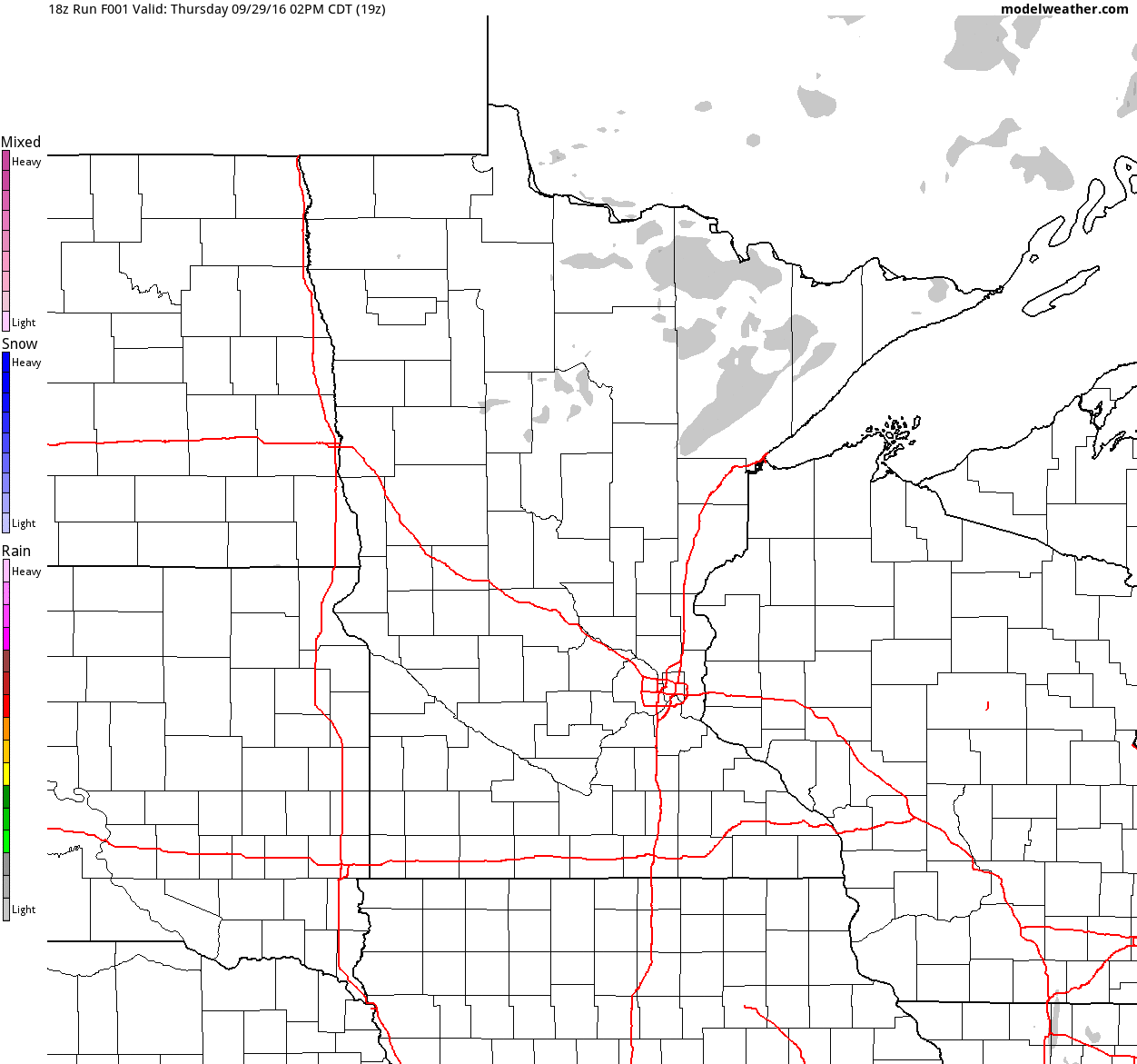
Simulated Radar
The simulated radar from Thursday to Sunday shows mostly dry weather continuing across the region with only a few spotty showers possible closer to the Great Lakes.
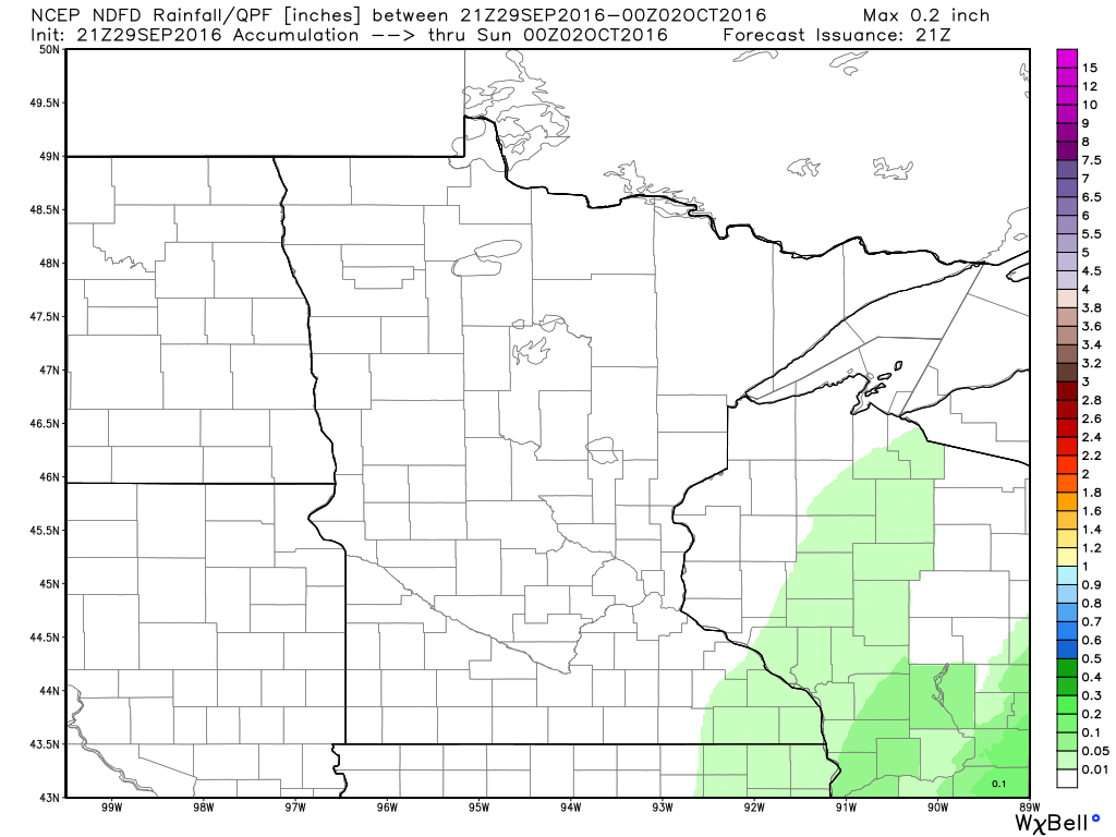
Rainfall Potential
Rainfall potential through PM Saturday suggests a few light showers possible across the extreme southeastern Minnesota and central Wisconsin. Other than that, most locations will stay mostly dry through the weekend.
_________________________________________
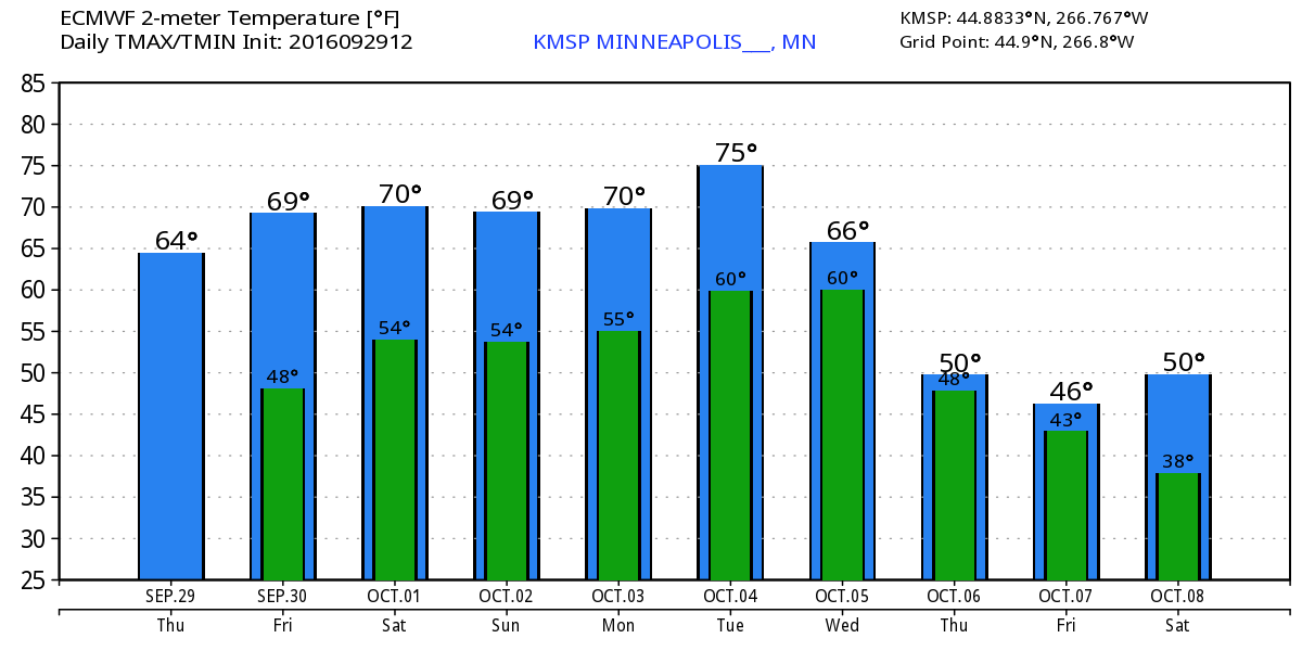
Extended Weather Outlook
The extended temperature outlook over the next 10 days suggests temperatures warming slowly over the next few days to near 70F over the weekend and early next week. There appears to be a quick jump into the mid 70s on Tuesday before a fairly significant cold front sweeps through by the end of next week. High temperatures by the second of October looks to be potentially very chilly.
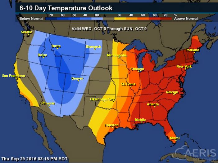
6 to 10 Day Temp Outlook
According to NOAA's Climate Prediction Center, warmer than average temperatures look to continue across the Great Lakes Region, but note the cooler than average temperatures lurking just to the west. This could potentially make for a chilly second weekend of October if it indeed does move through.
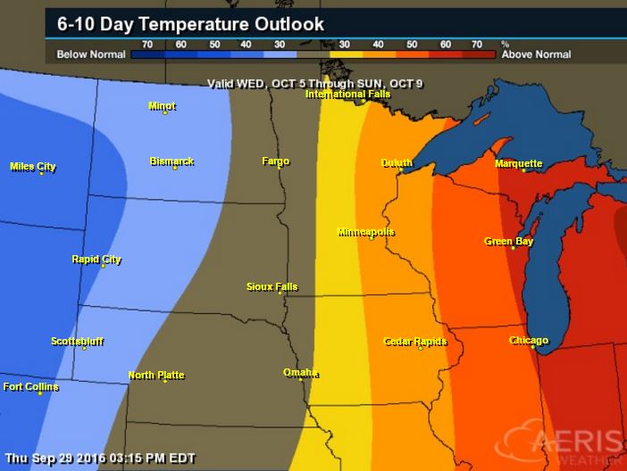
6 to 10 Day Temp Outlook
Here's the national temperature outlook from October 5th - 9th, which shows warmer than average conditions across the eastern two-thirds of the nation with cooler than average temperatures returning to places in the Intermountain-West
__________________________________________
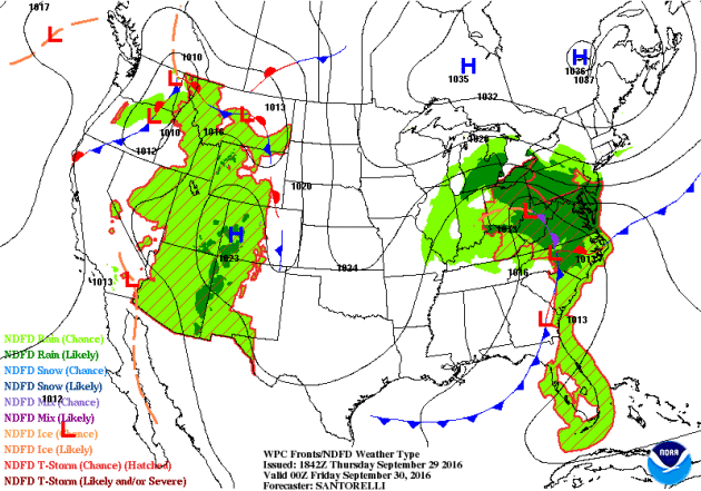
National Weather Outlook
A stalled and slow moving area of low pressure over the Ohio Valley/Great Lakes Region will slowly move north/northeast over the weekend. Heavy rains will still be possible across parts of the northeastern U.S., while mostly dry weather looks to continue in the Central U.S.. Heavier, steadier rain looks to move in along the West Coast as a large storm system moves in. This will bring mountain snow back into the Western U.S. over the next 5 days.
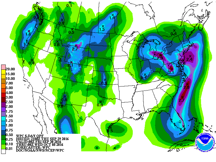
Precipitation Outlook
The heaviest rainfall over the next few days will be found in the Great Lakes Region and parts of the Northeast with some isolated flood concerns possible. There will also be some heavier rainfall tallies possible across the Intermountain West and along the West Coast.
___________________________________________
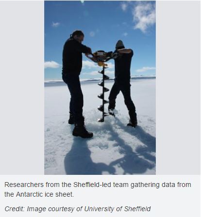
"Climate change jigsaw puzzle: Antarctic pieces missing"
"A shift in westerly winds, which has led to climate impacts in Australia and the Southern Ocean, is human-induced, new research suggests. To date, limited data on Antarctic climate has meant that it’s been difficult to disentangle changes caused by human activity from natural fluctuations."
_____________________________________________________________________
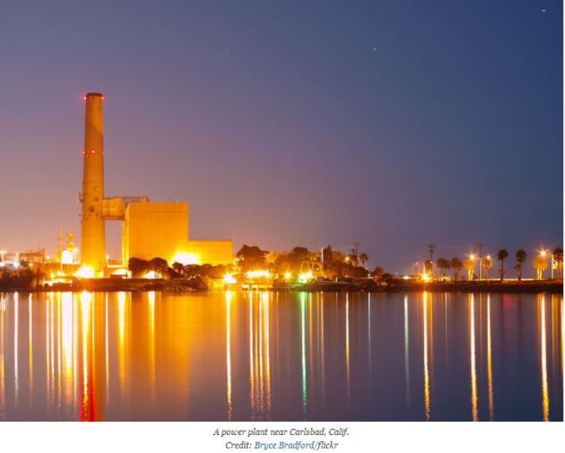
"Appeals Court Mulls Challenge to Clean Power Plan"
"Six hours and 42 minutes. That’s how long the legal challenge to the Obama administration’s Clean Power Plan was argued before a federal appeals court on Tuesday — more than double the time the court allotted for the hearing. The Environmental Protection Agency’s most important greenhouse gas emissions regulation is being challenged by a group of 24 states led by West Virginia with support from the fossil fuel industry. The challenge was heard before 10 of the 11 judges for the U.S. Court of Appeals for the District of Columbia Circuit. U.S. Supreme Court nominee Merrick Garland recused himself."
______________________________________________
Thanks for checking in and don't forget to follow me on Twitter @TNelsonWX

No comments:
Post a Comment