69 F. average high in St. Cloud on September 20.
72 F. high on September 20, 2015.
September 21, 2005: An unusually intense late season severe weather event affects parts of central Minnesota and west central Wisconsin during the late afternoon and evening hours. Baseball-sized hail, damaging thunderstorm winds, and tornadoes result from several supercell thunderstorms. The most widespread damage occurs across the northern and eastern portions of the Twin Cities. Three tornadoes rake across parts of Anoka and northern Hennepin counties, including an F2, but the tornado damage is overshadowed by the widespread extreme wind damage associated with the rear flank downdraft of the supercell. In addition to the severe weather, many locations received substantial amounts of rain. Many streets and underpasses in the northern Twin Cities metro area were flooded Wednesday night, where radar precipitation estimates were in excess of 3 inches.
September 21, 1994: 1/2 inch hail in Blue Earth County results in $6 million in crop damages.
September 21, 1924: Very strong winds occur in Duluth, with a peak gust of 64 mph.
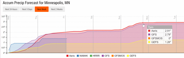
2 to 4 Inches of Rain by Sunday? Flash Flood Risk
At yesterday's Association of Minnesota Emergency Managers I asked what keeps these professionals up at night.
The answers surprised me.
From Beltrami County: high winds impacting our forests. The Bemidji area experienced 4 separate storms packing 80-100 mph winds in July. From Ramsey County: ice. A major freezing rain event could paralyze the metro with power outages lasting days, even weeks.
Dan Luna, heading up the Twin Cities National Weather Service, worries about a 1965 Fridley-like tornado outbreak. "If an EF-4 tornado hits the metro and we do everything right - the warnings are accurate - will the public do the right thing?" Luna asked.
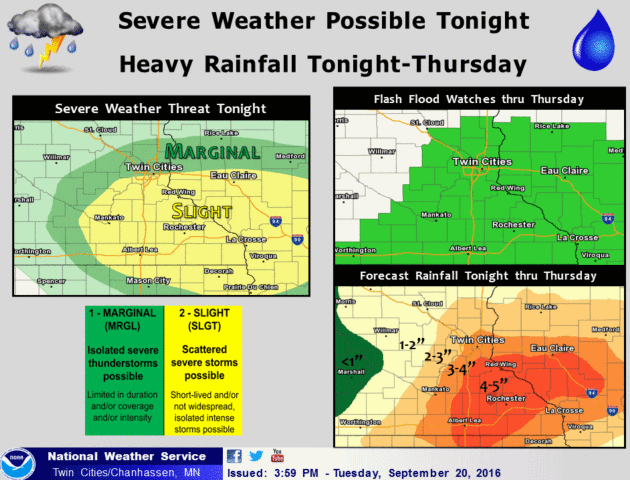
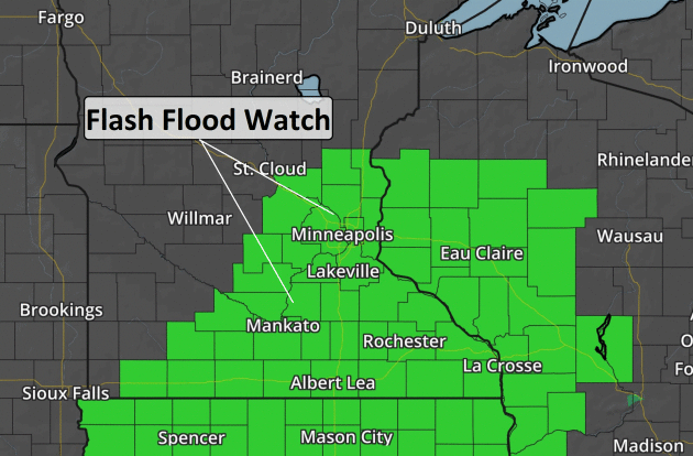
Roving gangs of thunderstorms may squeeze out 2-3 inches of additional rain by Thursday night; as much as 3-6 inches south/east of MSP. The result: an elevated risk of urban and river flooding, and that's why a Flash Flood Watch is posted until Thursday evening.
Yes, it's a little unnerving tracking flooding storms in late September, when we should be watching the leaves change color.
Some of this moisture is from Tropical Storm Paine, which hit Baja California. Paine, as in Paine in the ... Doppler.
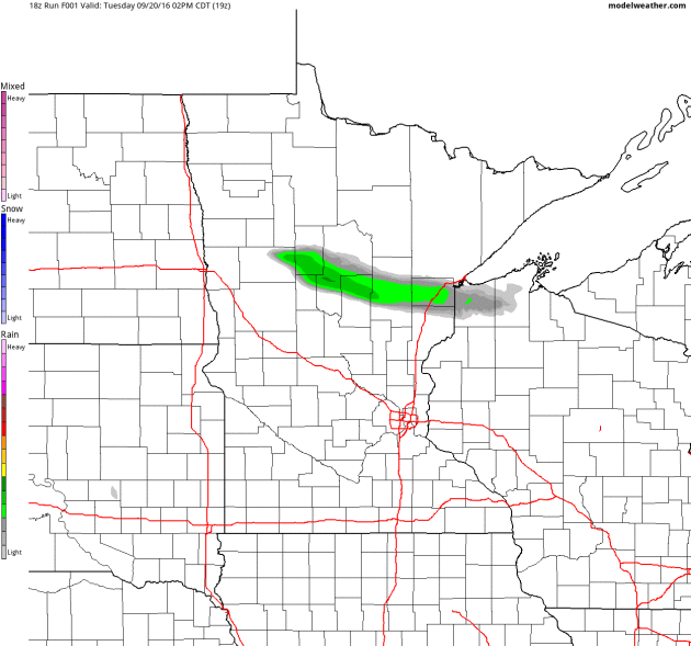
4km NAM Future Radar courtesy of NOAA and AerisWeather.
- Potential Impacts: Flooded roads, rising rivers, urban flash flooding.
- Timing: Southern Minnesota tonight, central/southern Minnesota and western Wisconsin Wednesday through Wednesday evening, southeastern Minnesota and Wisconsin Thursday.
- Amounts: Widespread 2 to 4 inches, locally 6+ inches - especially in the Moderate Risk area for flash flooding shown below.
- Forecast Confidence: High for potential impacts and timing. Moderate for location of heaviest rain/flood risk and amounts.
FLOOD WATCH
NATIONAL WEATHER SERVICE TWIN CITIES/CHANHASSEN MN
700 PM CDT TUE SEP 20 2016

...MULTIPLE ROUNDS OF HEAVY RAINFALL WILL BRING AN INCREASING
RISK OF FLOODING THROUGH THURSDAY...

.A FLASH FLOOD WATCH REMAINS IN EFFECT FOR MUCH OF EASTERN AND
SOUTHERN MINNESOTA AS WELL AS WEST CENTRAL WISCONSIN FOR TONIGHT
THROUGH THURSDAY. THE WATCH AREA IS ALONG AND SOUTH OF A LINE FROM
SPRINGFIELD TO APPLE VALLEY TO EAU CLAIRE.

RAINFALL AMOUNTS ARE FORECAST TO RANGE FROM 2 TO 5 INCHES ACROSS
SOUTH CENTRAL MINNESOTA TO PORTIONS OF WEST CENTRAL WISCONSIN
ALONG AND SOUTH OF I-94. TWO TO 3 INCHES SHOULD FALL FURTHER
NORTH ACROSS CENTRAL MINNESOTA AND THE REST OF WEST CENTRAL
WISCONSIN. LOCALLY HIGHER AMOUNTS ARE LIKELY...PARTICULARLY ACROSS
SOUTHERN MINNESOTA.

CONFIDENCE WITH THE HEAVY RAINFALL POTENTIAL IS FAIRLY HIGH. THE
PATTERN FOR MIDWEEK CLOSELY MIMICS SEVERAL HIGH END RAINFALL
EVENTS IN THE PAST...INCLUDING SEPTEMBER 23 2010 WHERE RAINFALL
TOTALS OF 5 TO 8 INCHES FELL ACROSS ALL OF SOUTHERN MINNESOTA.
MAJOR FLOODING RESULTED.
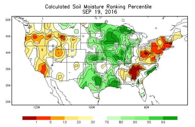

- A period of very wet weather is setting up tonight through Thursday across parts of the upper Midwest. The target of heaviest rain currently is from southern Minnesota and west-central Wisconsin, but the axis could still shift slightly.
- At least 2-5” of rain will fall across portions of Minnesota and Wisconsin between tonight-Thursday along a stalled frontal boundary, with isolated higher amounts possible.
- This will lead to the potential of flash flooding in the region as well as rising lake and river levels.


Because of the uncertainty in the placement of the front, local weather service offices are holding off on issuing Flash Flood Watches at this moment. However, I would expect watches to be issued later today across southern Minnesota and western Wisconsin.


Summary. A warm front will be lifting northward tonight across the upper Midwest before stalling out across portions of southern Minnesota and central Wisconsin. With a very moisture-rich environment, rounds of heavy rain are expected along and near that frontal boundary, with at least 2-5” of rain expected. Isolated 6”+ are possible, especially over southeast Minnesota. Due to the expected excessive rain amounts, flash flooding can be expected across this region, especially on Wednesday. Facilities across these areas that normally experience problems during flash flood scenarios should be on alert for issues over the next few days.
D.J. Kayser, Meteorologist, AerisWeather

The Standoff Between Big Oil and Big Corn. The New York Times reports: "A
decade ago, lawmakers in Washington tried to address a trifecta of
thorny challenges with one simple fix that has turned out to be anything
but easy to assess. The problems: an overreliance on foreign oil, rising greenhouse gas emissions and tepid economic growth. The solution: the Renewable Fuel Standard,
commonly known as the ethanol mandate. Enacted in 2005 and expanded two
years later, the legislation required that refiners blend an increasing
amount of biofuel into the gasoline that powers most American cars..."

Photo credit: "Cambodian land rights activists shout slogans during a protest in front of the Phnom Penh municipal court on Aug. 22 to demand the release of two prominent activists who were sentenced to six days in jail." (Tang Chhin Sothy/AFP).


Toyota Is Using Sewage Sludge to Power Its New Electric Car. Interesting, but I think I'll pass. Here's an excerpt at Quartz: "...But
Toyota thinks it may have found a solution. For unlimited clean energy,
it’s turning to one of the dirtiest places there is: the toilet. In
Fukuoka, Japan, the automaker is converting human waste into hydrogen to
fuel the Mirai. The process is pretty simple. At a wastewater treatment
plant, like the Fukuoka City Central Water Processing Plant, sewage is
separated into liquid and solid waste. The solid waste, called sewage
sludge, is exactly what it sounds like: a foul-smelling, brown lump.
Most sewage sludge is thrown in landfills..."
Photo credit: "Highest of tech; powered by human waste." (Reuters/Gary Cameron)
Bank of America Pledges To Go "Carbon Neutral" by 2020. To save the Earth, or because it's good PR? Perhaps, but more important to the bottom line, shareholders and employees they're doing it to become more resilient - and save money. Details at Business Green.

How To Raise Trillions for Green Investments. Former Treasury Secretary Henry Paulson has an Op-Ed at The New York Times: "...The
good news is that there is a global abundance of private capital. To
unlock these riches, governments must create conditions that encourage
private investment in clean technologies and sustainable development.
With smart, well-designed and coordinated policies, financing models and
instruments like bonds and incentive programs, countries have the
potential to solve some of the planet’s most pressing environmental
challenges while still maintaining economic growth. That is why it is
essential for world leaders meeting in New York this week for Climate Week to stay focused on building an international consensus around “green finance...” (Illustration credit: Mikel Jaso).
Mendota Heights Makes Changes to Solar System Ordinance. Lillie Suburban Newspapers has the story: "Residents of Mendota Heights who wish to use alternative energy systems will now have fewer steps to go through for their roof-mounted solar energy units. At the Sept. 6 meeting, the Mendota Heights City Council approved amendments to the current ordinance governing the installation of solar panels. Nolan Wall said the council adopted an ordinance in September 2015, which created standards for alternative energy systems. “The intent with that ordinance was to ensure the same standards are applied to each solar energy system,” Wall said. Ultimately, this was to encourage sustainable practices that did not adversely impact the community..."


1. Utah
2. Minnesota
3. North Dakota
4. Hawaii
5. Colorado


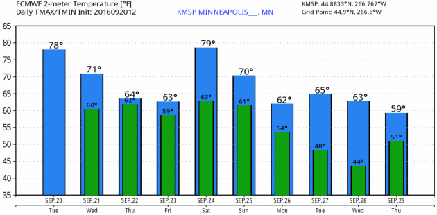
TODAY: Flash Flood Watch. Heavy showers and T-storms. Winds: E 10-15. High: 73
WEDNESDAY NIGHT: T-storms, locally heavy rain with a flash flood risk. Low: 62
THURSDAY: Rain, heavy at times. Lingering flood risk. Winds: NE 8-13. High: 69
FRIDAY: More showers and T-storms. Winds: E 10-20. Wake-up: 58. High: 66
SATURDAY: Some warm, sticky sun, T-storms late. Winds: SE 10-20. Wake-up: 62. High: near 80
SUNDAY: Showers, storms taper, PM clearing possible. Winds: W 8-13. Wake-up: 63. High: 72
MONDAY: Sunny and dry. It's a miracle. Wake-up: 56. High: 71
TUESDAY: Plenty of sun, still very pleasant. Wake-up: 52. High: 72
Climate Stories...

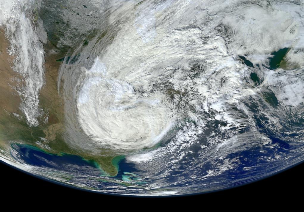
Climate Disruption is Fueling Stronger Storms. Friend and colleague Jeff Masters is staring at the same weather maps I am; here's an excerpt of an interview with PRI, Public Radio International: “I don't recognize the climate anymore,” says Jeff Masters, the director of meteorology for Weather Underground. “I look at the weather maps in the morning, sometimes afraid of what I'm going to see. It's just gotten so insane. The climate of the 20th century is gone. The climate I knew is not here anymore. We're in an entirely new climate regime, and it is extremely intense.” Climate scientists have been reluctant to attribute any one storm to the effects of climate disruption, but this may soon start to change. After historic rains fell on parts of Louisiana — an estimated 7.1 trillion gallons, three times as much as Hurricane Katrina — NOAA published a report which said that climate change made the storm at least 40 percent more likely today than a hundred years ago..."
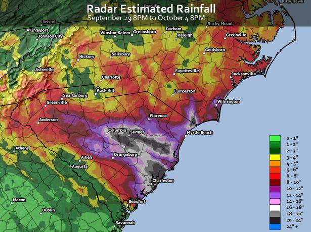

Photo credit: Friends of Cooper Island.

Graphic credit: "Policy experts talked climate change at the National Press Club Thursday." Visual by Georgetown Climate Center.
Graphic credit: "A figure from the withdrawn study, arguing that the model accurately predicts planetary temperatures." (Courtesy of Ned Nikolov).
No comments:
Post a Comment