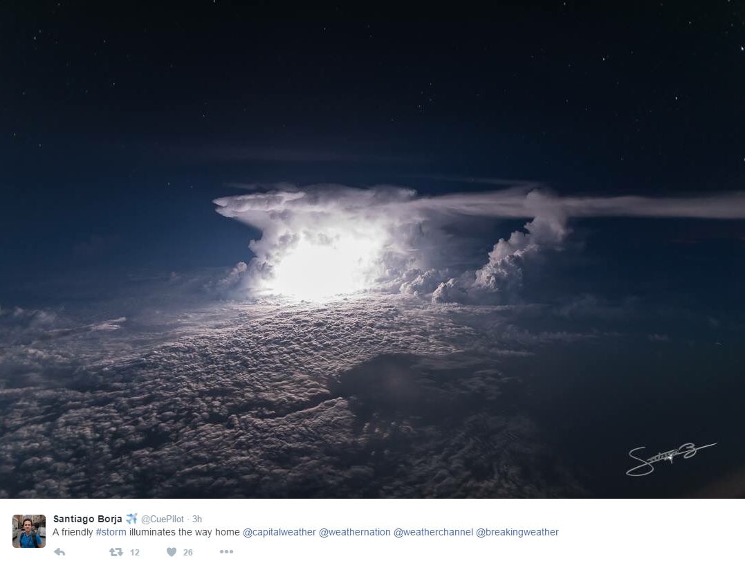
Friendly Storm From the Air
What an unreal picture from @CuePilot who is an airplane pilot and photographer based in Ecuador! He recently snapped this picture on his way home! WOW!
Windy Monday
Here's the visible satellite loop from Monday with wind gusts as well. First, note that widespread cloud cover and scattered rain showers enveloped much of northern Minnesota and Wisconsin for much of the day. Also note how many and how widespread the double digit wind gusts were yesterday.
Here's a list of all the tropical storm force wind gusts that were recorded on Monday!

_____________________________________
_____________________________________
What's Happening At Hazeltine?
After several rounds of heavy rain over the past couple/few weeks, it appears that the weather will calm down just in time for one of the biggest golf events in the world! The big stage goes to Hazeltine National Golf Club located in Chaska, MN. It has been a pleasure watching and following Chris Tritabaugh @CT_turf and his other crew members on twitter as he as his amazing crew have prepared for the Ryder Cup event this week. This is a picture that Chris posted on Monday as the sun was popping out after a very wet week last week.

Here's the crew taking care of the heavy rain last week. Note that Minneapolis airport alone has seen 5.43" of rain so far this month, which is 2.83" above average!

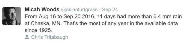
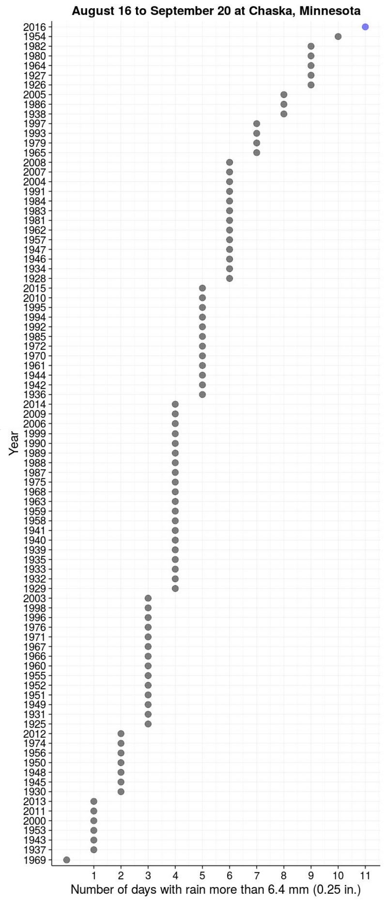
A Very Wet Stretch of Weather Leading up to Ryder Cup in Chaska
Take a look at this nugget from Micah Woods @asianturfgrass who found that from August 16th to September 20th 2016, 11 days had more than 0.25" of rain at Chaska, MN. According to his findings, that is the most of any year on record since 1925!
_____________________________
A Wet September
Here's a snippet from Mark Seeley's WeatherTalk from Friday, September 23rd, which helps describe how much rainfall we've seen this month and so far this year in some places.
_____________________________________
A Wet September
Here's a snippet from Mark Seeley's WeatherTalk from Friday, September 23rd, which helps describe how much rainfall we've seen this month and so far this year in some places.
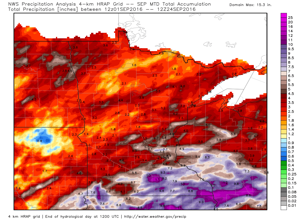
"This wet September continues a trend toward above normal precipitation. Some climate stations in Minnesota have already received over 40 inches of precipitation for the year. Further at least ten climate stations are on a pace to set a new record wet year, including St James with 40.59 inches (2nd wettest year in history), and Waseca with 48.68 inches (2nd wettest year in history), and over three months to go in 2016! It is also likely that the all-time state record wettest single year, 53.52 inches at St Francis (Anoka County) in 1991 will be broken before the end of this year."
(Image below shows estimated rainfall since September 1st)
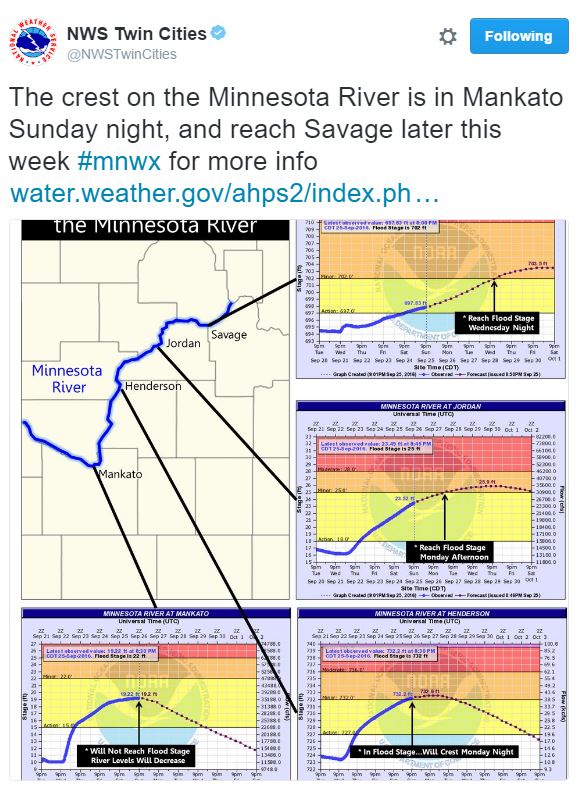
River Flooding Continues
Thanks to heavy rainfall last week, river flooding is still a big problem. Note that flood warnings continue along the Minnesota River as the river is expected to crest through the week ahead.
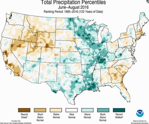
Wettest Meteorological Summer Record so Far (For Some)
According to NOAA, some locations across the central part of the country saw its wettest June through August (Meteorological Summer) on record. Note that some of these locations include parts of Minnesota, western Wisconsin and northeast Iowa.
_____________________________________
Signs of Fall Closer to Home
Slowly, but surely signs of fall are beginning to pop up. A few more trees and bushes are beginning to turn color and over the few weeks, we will be inundated with brilliant colors everywhere!
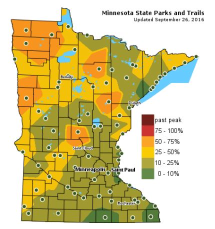
Fall Color Update
The latest update from the MN DNR shows that we are well on our way in the fall color department with some 50% to 75% color being reported across parts of Central and Northwestern Minnesota. Note that only 10% to 25% color can be found across the Twin Cities; the average peak there is generally late September to mid October.
___________________________________________
Wind-whipped PM showers possible later Tuesday; Sunny and better by Thursday
I feel a little disheveled after yesterday's tropical storm force wind gusts blew into town. Thank goodness we weren't deeper into the fall color season or we'd have leaves blowing all over the place. That reminds me, where did I put my rake? I am going to need it soon.
A large area of low pressure centered over Ontario is responsible for this windy nonsense. While wind gusts won't be quite as strong as they were Monday, we'll still have a nagging breeze to combat as you meander about outdoors. The low clouds surrounding the storm system will also make an appearance again Tuesday with passing showers that will likely be present during the afternoon hours.
Winds taper a bit and the sun slowly peeks out on Wednesday, but temperatures will still require an extra layer as you head out the door.
I am happy to report that the extended forecast suggests an extended period of sunny, dry and mild weather Thursday through Sunday; good news for the Ryder Cup. Props to Hazeltine for handling all the rain last week, the course looks amazing!
___________________________________________________
Extended Weather Outlook
MONDAY NIGHT: Mostly clear and a little breezy. Winds: 10-15. Low: 47
TUESDAY: Low clouds return with a few wind-whipped showers. Winds: WNW 10-20. High: 60.
TUESDAY NIGHT: Showers end early. Winds: NNW 10. Low: 47
WEDNESDAY: More sun and not as windy. Winds: N 5-15. High: 62
THURSDAY: Mostly sunny. Nice, quiet day. Winds: ESE 5-10. Wake-up: 48. High: 68.
FRIDAY: Bright sun, a touch warmer. Winds: ESE 5-10. Wake-up: 49. High: 70.
SATURDAY: Mostly sunny, a few high clouds. Winds: ESE 5-10. Wake-up: 52. High: 70.
SUNDAY: Filtered sun, still looks dry. Winds: SE 5-15. Wake-up: 51. High: 70.
MONDAY: Increasing clouds. Stray storms late. Winds: SE 10-20. Wake-up: 51. High: 71
_______________________________
_______________________________
This Day in Weather History
September 27th
1942: Minneapolis has a high temperature of only 40 degrees.September 27th
1898: A heat wave produces highs of 91 degrees at Beardsley and 90 at Moorhead.
________________________________
Average High/Low for Minneapolis
September 27th
Average High: 67F (Record: 88F set in 1987)
Average Low: 47F (Record: 29F set in 1991)
_________________________________
Average Low: 47F (Record: 29F set in 1991)
_________________________________
Sunrise/Sunset Times for Minneapolis
September 27th
September 27th
Sunrise: 7:07am
Sunset: 7:00pm
Sunset: 7:00pm
*Daylight Lost Since Yesterday: ~3mins & 6sec
*Daylight Lost Since Summer Solstice: ~3hours and 44mins
__________________________________
*Daylight Lost Since Summer Solstice: ~3hours and 44mins
__________________________________
Moon Phase for September 26th
2.7 Days Before New Moon
2.7 Days Before New Moon

___________________________________
Weather Outlook Tuesday
Tuesday will be another chilly day with highs across much of the state struggling to get to 60F. With gusty winds continuing, it'll feel even cooler than the actual high; very reminiscent of October!
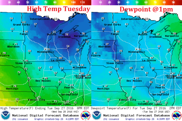
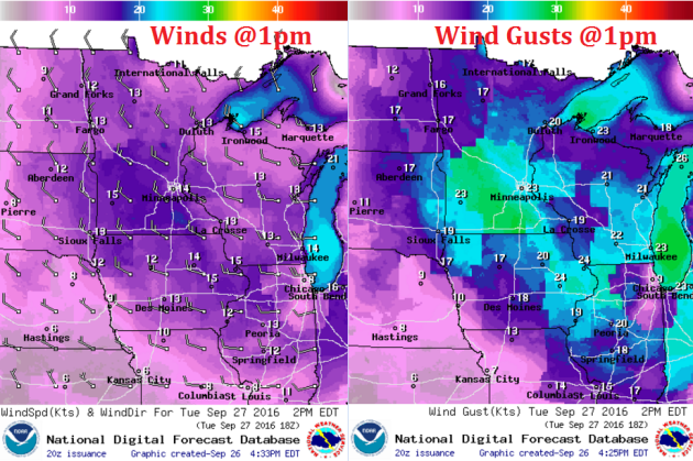
Weather Outlook Tuesday
Winds on Tuesday will once again be quite breezy. Not as bad as Monday was, but it'll still be breezy with gusts up to 20 to 25 mph.
Weather Outlook Tuesday
The large area of low pressure responsible for the gusty winds across the region on Monday will begin sagging south into the Great Lakes region on Tuesday. Wrap around clouds and showers will be found across eastern Minnesota and most of Wisconsin.
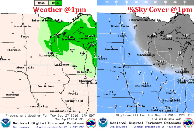
Simulated Radar
The simulated radar from Monday to Wednesday shows wrap around showers across northern Minnesota drifting south through the region PM Tuesday through early Wednesday. Note that most locations won't see much in terms of accumulation.
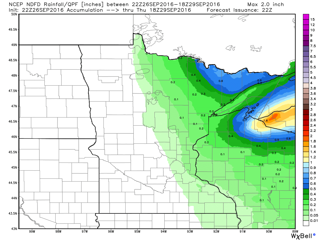
Rainfall Potential
Additional rainfall looks heaviest across the northeastern part of the state and into northern Wisconsin. Some locations may see up to 0.5" or more, while locations closer to the Twin Cities will see much lighter amounts.
_________________________________________
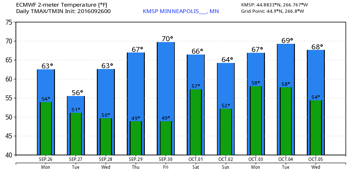
Extended Weather Outlook
The extended temperature outlook over the next 10 days suggests temperatures dropping back down to below average levels through the middle part of next week in the wake of the cold front that moved through PM Saturday/AM Sunday. Slowly, temperatures climb to near average levels by the end of the week and into the first part of October!
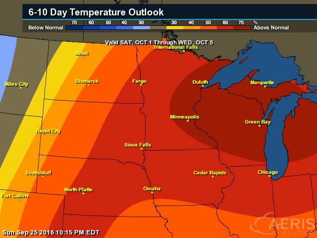
6 to 10 Day Temp Outlook
According to NOAA's Climate Prediction Center, warmer than average temperatures look to sneak back into the Upper Midwest as we get into early October. However, temperatures over the next couple of days look a littler cooler and could require some longer sleeves.
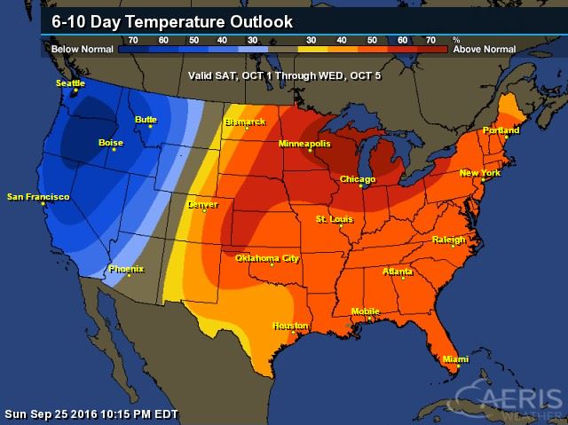
6 to 10 Day Temp Outlook
Here's the national temperature outlook from October 1st - 5th, which shows warmer than average conditions across the eastern two-thirds of the nation with cooler than average temperatures returning to places along the West Coast.
__________________________________________
National Weather Outlook
A large area of low pressure will slowly slide through the Great Lakes on Tuesday and Wednesday with colder temperatures, low clouds and spotty showers. The storm seems to almost stall in the Ohio Valley, which will prolong heavier rainfall potential across the East Coast.
Precipitation Outlook
After a notably wet week across the Central U.S. last week, there appears to be an extended period of dry weather. Heavier rainfall looks to move into parts of the Northeast where they could use the rain. Some spots there could see 2" to 4" of rain or more through the end of the week.
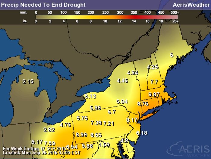
Precipitation Needed to end Drought in the Northeast
The good news is that the rain will be much needed in the Northeast as some locations need nearly 5" to 9" or more to end the drought.
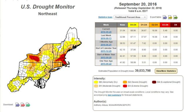
Northeast Drought Monitor
According to the U.S. Drought Monitor, nearly 69% of the region is considered to be abnormally dry, while 16% of the region is in a severe drought and 5% is in an extreme drought, including Boston, MA
__________________________________________
Tracking the Tropics
The National Hurricane Center is keeping a close eye on this particular wave of energy as it drifts closer to the Caribbean. As of PM Monday, it has a high probability of tropical formation within the next 5 day.
Watching the Tropics
Some of the latest model guidance suggests that this system will gain tropical storm strength within the next couple of days, while some also suggests that this storm could become a hurricane! Stay tuned...
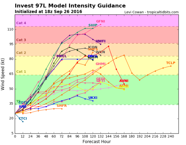
Watching the Tropics
Here's a host of different models and solutions, which show a range in its path from just north of South America to east of the East Coast.
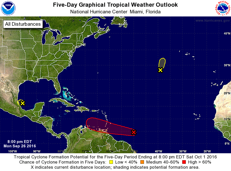
Atlantic 5 Day Outlook
According to NOAA's NHC, the 5 day outlook suggests a HIGH chance of tropical formation with a wave of energy drifting closer to the Caribbean. With the continued northwest track, this storm is worth watching... Stay tuned.
___________________________________________
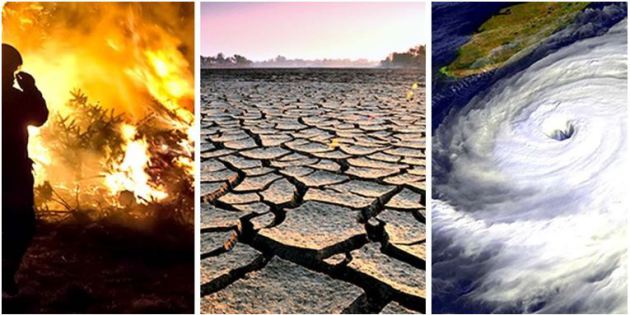
"Earth Could Reach Critical Climate Threshold in a Decade, Scientists Warn"
"Speaking at a University of Oxford conference this week, led by leading UK climate researcher Richard Betts, scientists said global greenhouse gas emissions are not likely to slow down quickly enough to avoid passing the 1.5°C target. The goal of limiting global warming to 1.5°C was agreed to in the landmark Paris agreementnegotiated by 195 nations last year. But the planet is continuing to experience unprecedented heat month after month, setting 2016 on track to be the hottest year ever recorded. In fact, the scientists said, Earth is currently on a trajectory to hit at least 2.7°C in global temperature rise. Pete Smith, a plant and soil scientist at the University of Aberdeen in Scotland, said mass lifestyle change must be undertaken to combat rising temperatures, such as developing more sustainable diets, reducing food waste and red meat intake, and importing fewer greenhouse gas-heavy vegetables. "There are lots of behavioral changes required, not just by the government ... but by us," he said. He also warned that controversial geoengineering techniques such as sunlight blocking could become the norm in some countries. The warning came the same day that Oil Change International released a report that found we have 17 years left to get off fossil fuels, or else face unprecedented and irreversible climate catastrophe."
Thanks for checking in and don't forget to follow me on Twitter @TNelsonWX

Did you know you can shorten your urls with LinkShrink and make cash for every visitor to your short urls.
ReplyDelete