
Fall Color Update
According to the MN DNR, much of the state is now past peak in the fall color department. There are only a few pockets of peak color left across the southern part of the state.

___________________________________________________________________________
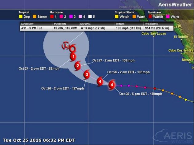
Here's a look at Hurricane Seymour in the Eastern Pacific from Tuesday evening, which was a major category 4 storm with winds sustained at 130mph
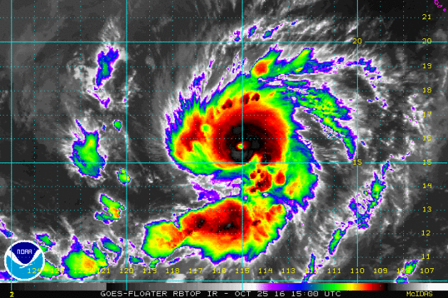
The latest forecast track from NOAA's HPC suggests that Seymour will weaken over the next few days as it drifts northwest.
Temps will remain quite chilly across the Northeast over the next several days as the trough of low pressure continues to cycle down colder Canadian.
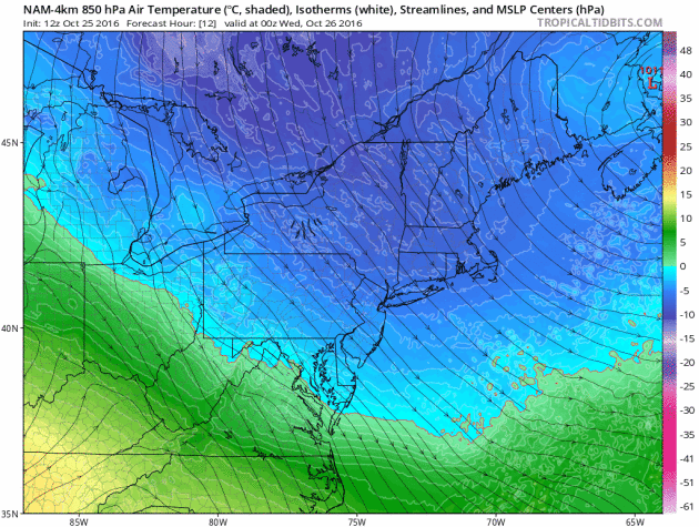
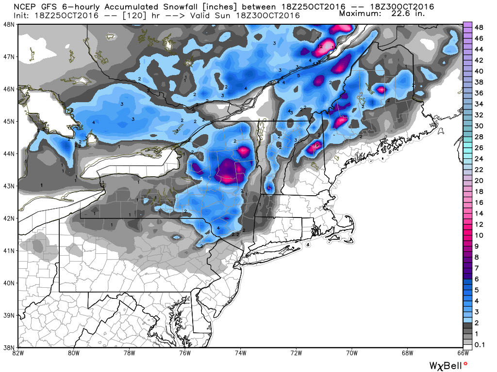
Lingering cold air in the Northeast will set the stage for additional snowfall as another storm system moves in from the west. It appears that the heaviest will be found across the far north and in the highest elevations.
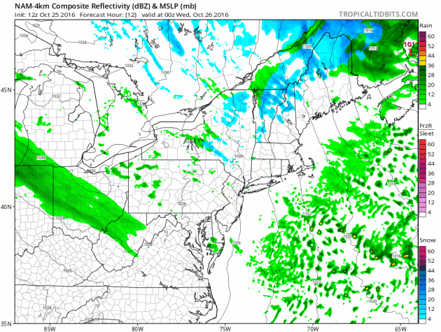
As our next storm system moves in from the west, snowfall accumulations will begin to tally up. Here's a look at how much snowfall could be possible through the weekend. Keep in mind that the heaviest will be found in the highest elevations.
 _____________________________________________________________________________
AM Puddles, Slow Clearing Wednesday. Mild By Friday
The pitter-patter of an October rain lulls us to sleep Tuesday night. Waking up to puddles Wednesday morning, it's hard not to think about how wet it's been this year.
Prior to Tuesday's rain, the Twin Cities was 7 inches above normal precipitation since January 1st. I've noticed several muddy ruts in farmer fields, but they're getting the job done. According to the USDA, 55% of the corn and 95% of the soybeans in Minnesota have been harvested. Thanks to wet conditions this fall, harvests have been running up to 1 week behind the five-year average.
The good news is that after last night's dose of heavier rains across southern Minnesota, we should dry out for a few days. The mercury tips the 60 degree mark by Friday, which will be nearly 10 degrees.
We cool back down on Saturday, close to October norms, but the temperature roller coaster continues into early next week. The 2016 Halloween preview looks mild with a few showers. BOO!
According to the Climate Prediction Center, we stay warmer than average into early November.
___________________________________________________
Extended Weather Outlook
TUESDAY NIGHT: Scattered showers. Winds: ESE 10-15. Low: 42.
WEDNESDAY: AM showers and puddles. Lingering PM clouds. Winds: NNE 5-10. High: 49
WEDNESDAY NIGHT: Mostly cloudy and quiet. Winds:NE 5. Low: 39
THURSDAY: Drier with more sun. A little warmer. Winds: S 5-10. High: 56
FRIDAY: Partly sunny, mild and breezy. Winds: WSW 10-20. Wake-up: 46. High: 63.
SATURDAY: Cooler breeze. Few showers. Winds: N 5-15. Wake-up: 48. High: 55.
SUNDAY: Chilly start. Lukewarm afternoon sun. Winds: SE 5-10. Wake-up: 39. High: 55.
Halloween Monday: Spotty Halloween showers? BOO! Winds: WSW 10-15. Wake-up: 45. High: 58.
TUESDAY: Mild start to November. Winds: SW 5-10. Wake-up: 47. High: 56.
_______________________________
_______________________________
This Day in Weather History
October 26th
1996: A severe weather outbreak combined with a blizzard occurred across the upper Midwest. Intense low pressure tracking into Minnesota produced blizzard conditions over portions of South Dakota, while further east in Minnesota, unseasonably mild temperatures developed. Temperatures climbed to near 70, with dew points in the 50s. 1 to 1 3/4 inch hail and strong winds were reported in Lac Qui Parle, Yellow Medicine, Chippewa, and Swift Counties. These storms produced 12 tornadoes; the strongest of which received F2 ratings. Southwest of Alexandria in Douglas County, an F2 tornado with a 9 mile track destroyed several homes. One woman sustained broken bones and internal injuries when a portion of her house, with her inside, was launched 200 feet onto the interstate. This tornado also pushed over a 500 pound fuel tank. Tornadoes also touched down in Swift, Kandiyohi, Pope, Stearns, and Isanti Counties.October 26th
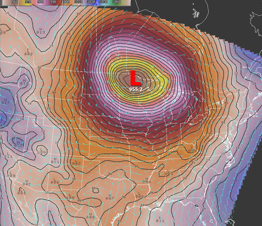
2010: The lowest pressure on record for Minnesota occurs in the town of Bigfork, with a reading of 28.21 inches of mercury (955.30 mb). Very strong winds were widespread throughout the state, with peak gusts of 65 mph recorded at both Georgeville (Stearns County) and Mehurin Township (Lac Qui Parle County).
See more from the Duluth National Weather Service HERE:
 ________________________________
Average High/Low for Minneapolis
October 26th
Average High: 53F (Record: 83F set in 1955)
Average Low: 36F (Record: 16F set in 1962)
_________________________________
Average Low: 36F (Record: 16F set in 1962)
_________________________________
Sunrise/Sunset Times for Minneapolis
October 26th
October 26th
Sunrise: 7:44am
Sunset: 6:09pm
Sunset: 6:09pm
*Daylight Lost Since Yesterday: ~2mins & 53sec
*Daylight Lost Since Summer Solstice: ~5hours and 12mins
______________________________________________________________________
*Daylight Lost Since Summer Solstice: ~5hours and 12mins
______________________________________________________________________
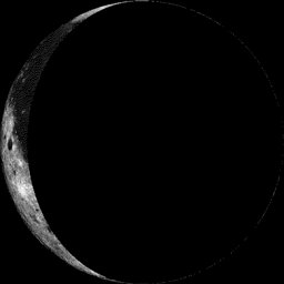
Moon Phase for October 25th at Midnight
3.5 Days After Last Quarter
3.5 Days After Last Quarter
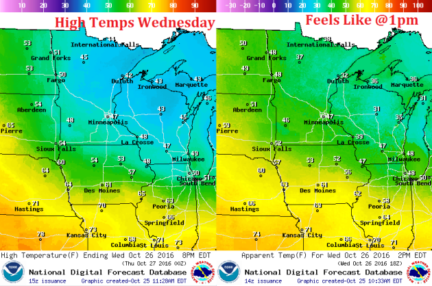
Weather Outlook Wednesday
High temperatures on Wednesday will be quite chilly across the region in the wake of the storm system that brought decent rainfall tallies across the region. Most locations won't make it out of the 40s.
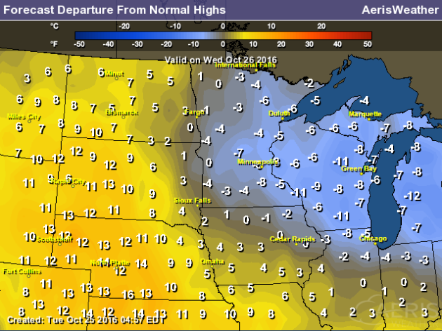
High Temperatures From Average Wednesday
Here's a look at high temps from average on Wednesday, which shows that much of Minnesota and Wisconsin will be below average.
Weather Outlook Wednesday
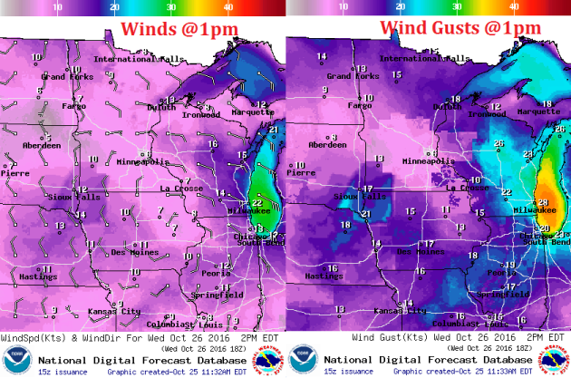
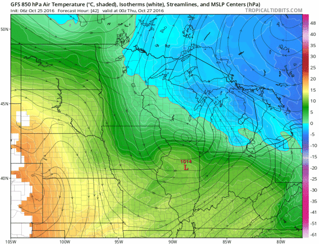
As the storm system moves east of the region, winds will slowly turn to the north allowing colder air to settle of the border. Note that winds don't appear to be too strong on Wednesday.
Weather Outlook Wednesday
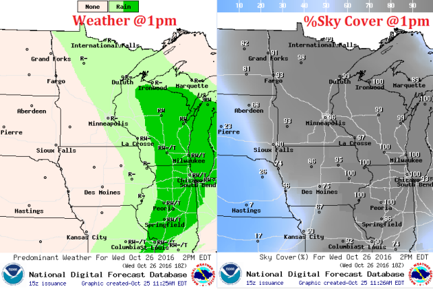
While the heaviest rainfall looks to push east of the region by PM Wednesday, light spits and cloudier skies will remain.
___________________________________________________________
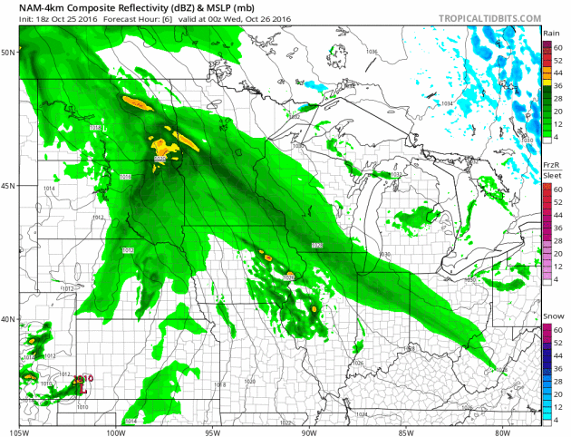
Simulated Radar
Scattered showers (some heavy at times) will continue to roll through the region late Tuesday - AM Wednesday with lighter showers possible across the Arrowhead and northern Wisconsin through PM Wednesday.
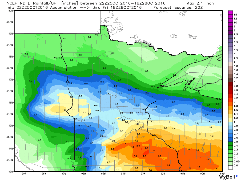
Rainfall Potential
Rainfall will add up through early Wednesday with total amounts reaching 1" or more across the southern half of the state. Some locations in southeastern Minnesota could see tallies near 2".
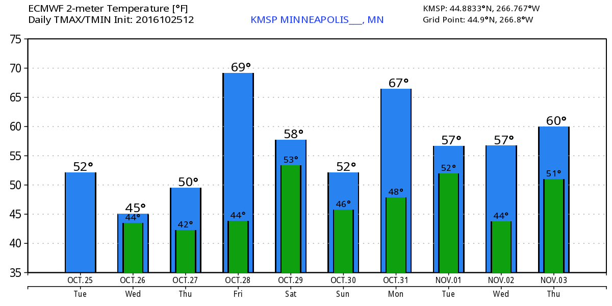
Temperature Roller Coaster
Temperatures by late week will warm up fairly quickly with high temps on Friday reaching the 60s across the southern part of the state, but a cold front will sweep through and knock temps back to near average on Saturday.
________________________________________
Extended Weather Outlook
The extended temperature outlook over the next 10 days suggests a gradual cooling trend through midweek as we bottom out in the 40s on Wednesday. However, note that temperatures look to rebound back into the 60s, by Friday!
Warm Temperatures Return to Midwest
According to NOAA's CPC, the 6 to 10 day temperature outlook suggests warmer than average temperatures continuing across much of the Upper Midwest as we head into the early part of November. It even looks like a fairly mild Halloween this year... stay tuned!
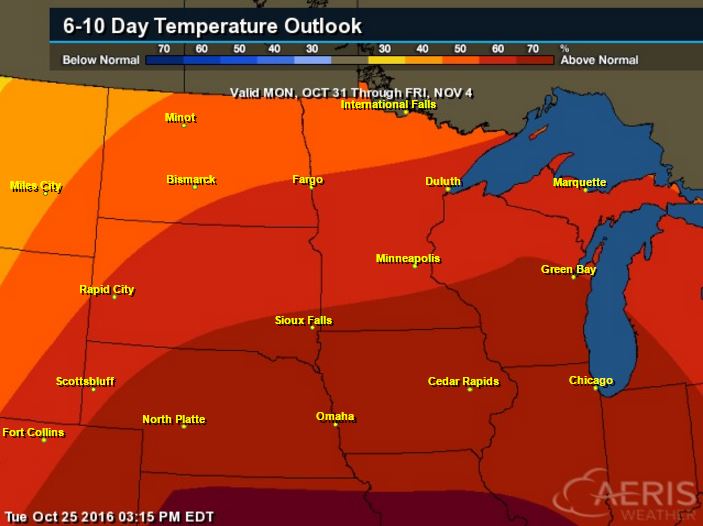
Here's the national temperature outlook from October 31st - November 4th, which shows warmer than average conditions across much of the nation.

__________________________________________
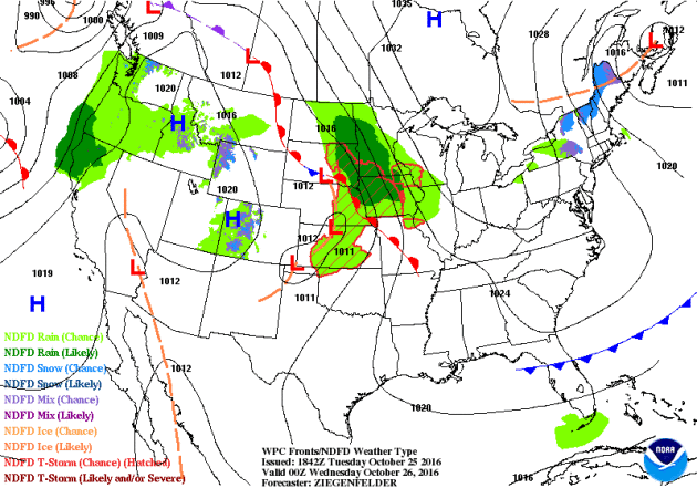
National Weather Outlook
A storm system moving through the Midwest will move into the Northeast later this week with scattered snow showers across the higher elevations. Meanwhile, heavier rain and wind will continue in the Western U.S. through the end of the week.
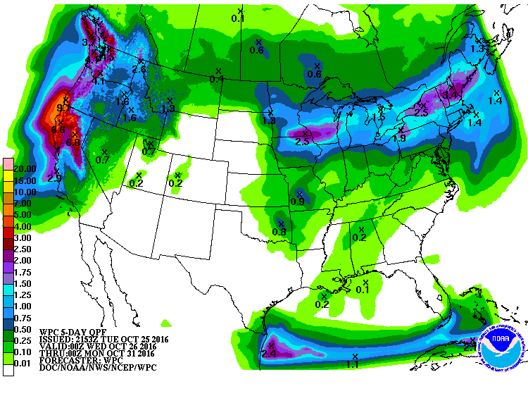
Precipitation Outlook
According to NOAA's WPC, heavier rainfall will be found from parts of the Upper Midwest to the Northeast. The heaviest rainfall will be found along the West Coast with some 3" to 6"+ rainfall tallies there.
 ______________________________________________
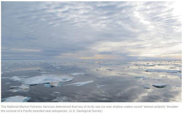
"Species may be listed as threatened based on climate change projections, court says"
"Federal authorities may list a species as “threatened” based on climate models that show habitat loss in the coming decades, an appeals court decided Monday. The state of Alaska, oil company groups and Alaskan natives had challenged a decision by the federal government to list a sea ice seal subspecies as threatened and deserving of protection. The challengers maintained the subspecies’ population was currently healthy and the climate projections were speculative. A three-judge panel of the San Francisco-based U.S. 9th Circuit Court of Appeals disagreed. The ruling would allow government protection of all sorts of wildlife likely to be affected by climate change in the decades ahead."
See more from LATimes HERE:
____________________________________________________________________
____________________________________________________________________
_____________________________________________________________________
Thanks for checking in and don't forget to follow me on Twitter @TNelsonWX
No comments:
Post a Comment