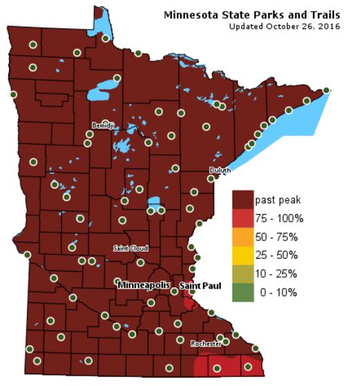
Fall Color Update
According to the MN DNR, much of the state is now past peak in the fall color department. There are only a few pockets of peak color left across the southeastern part of the state.
___________________________________________________________________________
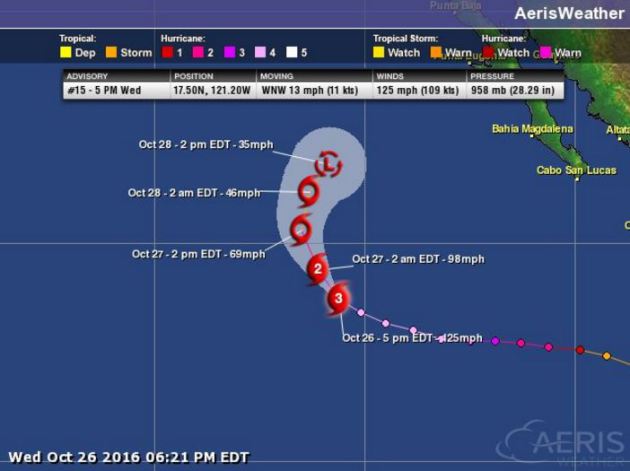
Here's a look at Hurricane Seymour in the Eastern Pacific from early PM Wednesday, which showed the storm going from a category 4 hurricane with winds sustained at 150mph to a category 3 storm with winds sustained at 125mph.

The latest forecast track from NOAA's HPC suggests that Seymour will weaken over the next few days as it drifts north.
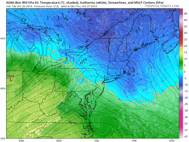
Cold air continues to linger in the Northeast through Friday, which will keep the threat for additional snowfall in place through the end of the week before we warm up this weekend.
More Snow in the Northeast
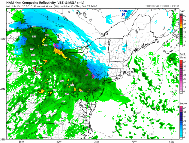
As our next storm system moves in from the west, snowfall accumulations will begin to tally up. Here's a look at how much snowfall could be possible through Friday. Keep in mind that the heaviest will be found in the highest elevations.

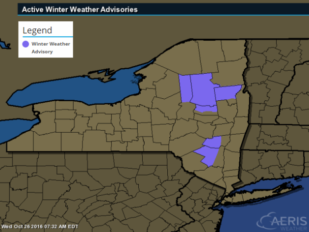
Winter Weather Advisory
...WINTER WEATHER ADVISORY REMAINS IN EFFECT THRU MIDNIGHT EDT THURSDAY NIGHT...
* LOCATIONS...SOUTHWEST ADIRONDACKS.
* ACCUMULATIONS...3 TO 7 INCHES...WITH LOCALLY HIGHER AMOUNTS POSSIBLE FOR ELEVATIONS ABOVE 2000 FEET.
* IMPACTS...SNOW COVERED ROADWAYS.
* WINDS...SOUTHEAST 15 TO 25 MPH.
_____________________________________________________________________________Drying Out. Warm October Winds on Friday
Wednesday's dank and dreary weather was a reminder that cloudier times are on the way. Whether we like it or not, slate gray will likely be Mother Nature's sky color of choice as we round out 2016. Note that November and December tend to be the 2 cloudiest months of the year averaging 18 days each month with cloudy skies.
The transition to colder weather can be somewhat volatile late in the fall. As air masses become more extreme and clash, they can whip up newsworthy storms like that of the 1991 Halloween Blizzard and the 1940 Armistice Day Blizzard. With that said, look for more wind driven and potentially more potent storm systems to develop over the next several weeks.
We dry out a little Thursday with a few peeks of sun. Mild winds develop on Friday in advance of another storm system that will track across southern Canada, which will allow temperatures to warm to near 70 degrees across the southern part of the state!
Halloween is also looking mild, but could feature blustery winds and a few light rain showers.
___________________________________________________
Extended Weather Outlook
WEDNESDAY NIGHT: Mostly cloudy and quiet. Winds:NE 5. Low: 39
THURSDAY: Lingering clouds. Warmer. Winds: S 5-10. High: 55
THURSDAY NIGHT: Mostly cloudy. Winds: SSE 5-10. Low: 47
FRIDAY: Partly sunny, mild and breezy. Winds: WSW 10-15. High: 69.
SATURDAY: A few chilly PM rain showers. Winds: NNE 5-10. Wake-up: 47. High: 54.
SUNDAY: Sun returns. Nothing rough. Winds: SE 5-15. Wake-up: 40. High: 56.
Halloween Monday: Blustery Halloween. Few showers. Winds: WSW 10-20. Wake-up: 46. High: 61.
TUESDAY: Gradual clearing. Not as breezy. Winds: WSW 5-10. Wake-up: 46. High: 55.
WEDNESDAY: Dry start. Showers develop late. Winds: NE 5-15. Wake-up: 42. High: 54.
_______________________________
_______________________________
This Day in Weather History
October 27th
1943: Residents would describe this event as 'one of the worst fogs in the Twin Cities in memory'. A very dense area of fog blanketed the area. In the thickest fog, street lights could not be seen 25 yards away. Drivers refused to cross unmarked railroad crossings and traffic was brought to a standstill.October 27th
1931: An intense area of low pressure moves into the Duluth area. The barometer falls to 29.02 inches.
________________________________
Average High/Low for Minneapolis
October 27th
Average High: 53F (Record: 74F set in 1948)
Average Low: 36F (Record: 13F set in 1997)
_________________________________
Average Low: 36F (Record: 13F set in 1997)
_________________________________
Sunrise/Sunset Times for Minneapolis
October 27th
October 27th
Sunrise: 7:45am
Sunset: 6:08pm
Sunset: 6:08pm
*Daylight Lost Since Yesterday: ~2mins & 52sec
*Daylight Lost Since Summer Solstice: ~5hours and 15mins
______________________________________________________________________
*Daylight Lost Since Summer Solstice: ~5hours and 15mins
______________________________________________________________________
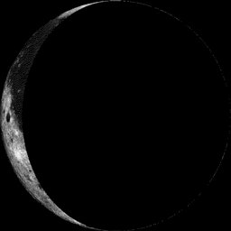
Moon Phase for October 26th at Midnight
3.5 Days After Last Quarter
3.5 Days After Last Quarter
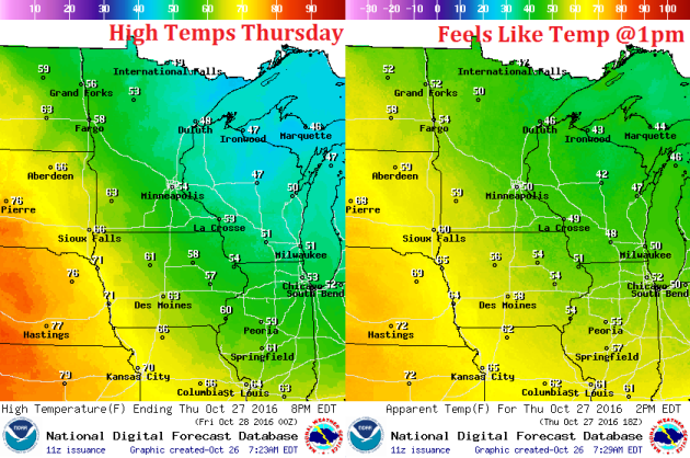
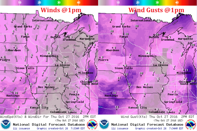
Weather Outlook Thursday
High temperatures on Thursday will be warmer than what we saw on Wednesday, except for locations closer to the Great Lakes. However, note that some 60s will be starting to move into the southwestern part of the state! This is the milder weather that will be moving in by Friday.
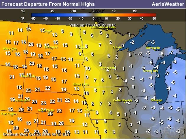
High Temperatures From Average Thursday
High temps from average on Thursday will start warming to above average levels once again across the western part of the state. This warmer weather will continue streaming into the region through Friday, where much of Friday looks to be 10F to 15F above average!
Weather Outlook Thursday
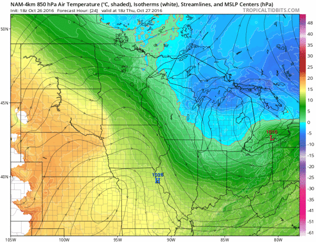
As our midweek soggy storm system pushes east, a southerly wind will start to develop on Thursday, which will help to warm temperatures through the end of the week.
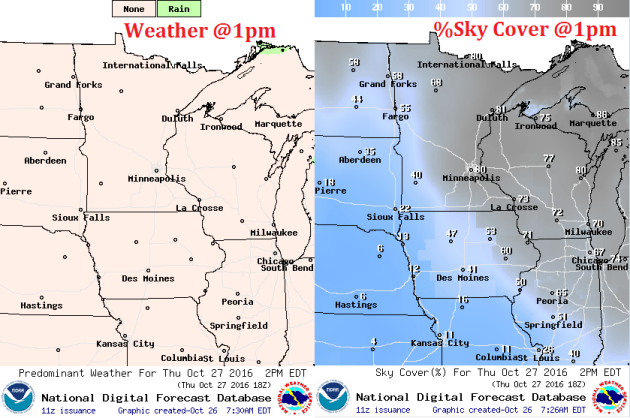
Weather Outlook Thursday
Our wet weather from earlier this week will have subsided, but clouds look to linger into Thursday with much of the state seeing mostly cloudy skies. However, note that parts of western Minnesota will start breaking out into more sun later in the day.
___________________________________________________________
Simulated Radar
The soggy weather that moved through midweek is long gone by Thursday. Drier weather will be in place for most of us through the end of the weekend, but a fast moving storm will race across southern Canada, which may bring a few light showers to the northern part of the state on Friday.
.gif)
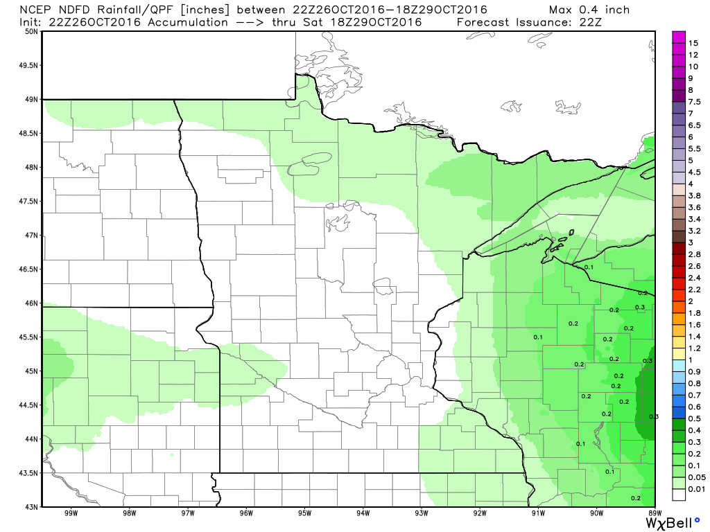
Rainfall Potential
Any additional light rainfall tallies that we see through the end of the week will be found along the international border. Most of us will stay dry.
Temperature Roller Coaster
After a chilly Wednesday, we warm up quickly through the end of the week with the warmest day moving in on Friday. Take a look at how warm the colors get as we slide into Friday.
Extended Weather Outlook
The extended temperature outlook over the next 10 days shows temperatures warming rather quickly by the end of the week with highs approaching 70F by Friday! We'll cool down to near normal levels this weekend, but readings remain quite mild through early November.

Warm Temperatures Return to Midwest
According to NOAA's CPC, the 6 to 10 day temperature outlook suggests warmer than average temperatures continuing across much of the Upper Midwest as we head into the early part of November. It even looks like a fairly mild Halloween this year... stay tuned!
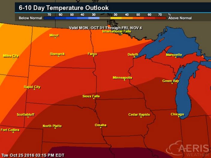
Here's the national temperature outlook from October 31st - November 4th, which shows warmer than average conditions across much of the nation.

__________________________________________
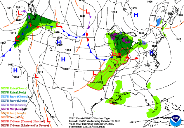
National Weather Outlook
The system that moved through the Midwest midweek will continue moving toward the Northeast through the end of the week with some accumulating snow potential through AM Friday. Meanwhile, heavier rain continues across the West Coast.
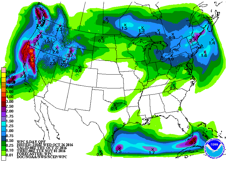
Precipitation Outlook
According to NOAA's WPC, heavier rainfall will push into parts of the Northeast through the end of the week, while heavy moisture continues along the West Coast.
 ______________________________________________
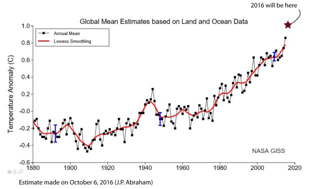
"The atmosphere is being radicalized' by climate change"
At Climate Progress, Joe Romm summarized the various ways in which global warming makes hurricanes like Matthew more intense:
Hotter sea surface and upper ocean temperatures fuel hurricanes, leading to more of the strongest (Category 4 and 5) storms.Hotter ocean temperatures also cause more rapid intensification of hurricanes, and the most intense storms are those that undergo rapid intensification.
Global warming causes sea level rise, which creates larger storm surges and thus worse flooding.
Global warming also adds more water vapor to the atmosphere, which causes more intense rainfall and exacerbates flooding.
In short, global warming made Hurricane Matthew and its impacts more severe, and will lead to more such devastating hurricanes in the future.
See more from TheGuardian HERE:
_____________________________________________________________________Thanks for checking in and don't forget to follow me on Twitter @TNelsonWX

No comments:
Post a Comment