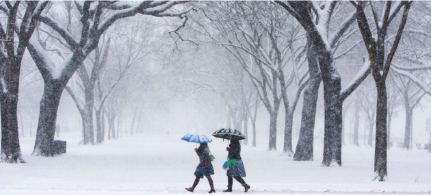
"U.S. Winter Outlook predicts warmer, drier South and cooler, wetter North"
"Forecasters at NOAA’s Climate Prediction Center issued the U.S. Winter Outlook today, saying that La Nina is expected to influence winter conditions this year. The Climate Prediction Center issued a La Nina watch this month, predicting the climate phenomenon is likely to develop in late fall or early winter. La Nina favors drier, warmer winters in the southern U.S and wetter, cooler conditions in the northern U.S. If La Nina conditions materialize, forecasters say it should be weak and potentially short-lived."
See more from NOAA HERE:
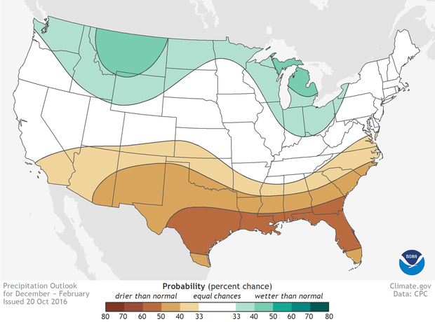
The 2016 U.S. Winter Outlook (December through February):
Precipitation
*Wetter than normal conditions are most likely in the northern Rockies, around the Great Lakes, in Hawaii and in western Alaska
*Drier than normal conditions are most likely across the entire southern U.S. and southern Alaska.
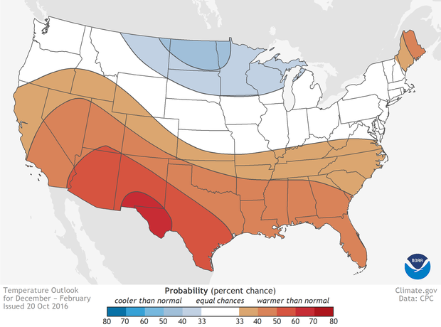
 Temperature
*Warmer than normal conditions are most likely across the southern U.S., extending northward through the central Rockies, in Hawaii, in western and northern Alaska and in northern New England.
*Cooler conditions are most likely across the northern tier from Montana to western Michigan.
*The rest of the country falls into the “equal chance” category, meaning that there is not a strong enough climate signal in these areas to shift the odds, so they have an equal chance for above-, near-, or below-normal temperatures and/or precipitation.
 _____________________________________________________________________________________
"Forecasters at NOAA’s Climate Prediction Center issued the U.S. Winter Outlook today, saying that La Nina is expected to influence winter conditions this year. The Climate Prediction Center issued a La Nina watch this month, predicting the climate phenomenon is likely to develop in late fall or early winter. La Nina favors drier, warmer winters in the southern U.S and wetter, cooler conditions in the northern U.S. If La Nina conditions materialize, forecasters say it should be weak and potentially short-lived."
See more from NOAA HERE:
The 2016 U.S. Winter Outlook (December through February):
Precipitation
*Wetter than normal conditions are most likely in the northern Rockies, around the Great Lakes, in Hawaii and in western Alaska
*Drier than normal conditions are most likely across the entire southern U.S. and southern Alaska.
*Warmer than normal conditions are most likely across the southern U.S., extending northward through the central Rockies, in Hawaii, in western and northern Alaska and in northern New England.
*Cooler conditions are most likely across the northern tier from Montana to western Michigan.
*The rest of the country falls into the “equal chance” category, meaning that there is not a strong enough climate signal in these areas to shift the odds, so they have an equal chance for above-, near-, or below-normal temperatures and/or precipitation.
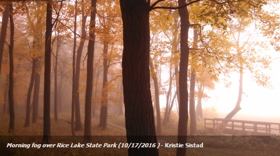
(Image above courtesy Kristie Sistad via MN DNR)
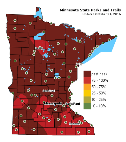
Fall Color Update
Colors
are fading fast across the state with many locations already reporting
past peak conditions. There are still a few spots across the southern
part of the state that are currently peaking! This is certainly the
weekend to get out and do a little leaf peeping!
Breezy Sunday. Cool Rain Arrives Tuesday
I
spent the last week in sunny Arizona visiting family. My parents told
me the "snowbirds" will be flocking by the dozens over the next several
weeks. I can see how snow-free roads in the winter would be enticing,
but I'm not ready to give up Minnesota winters just yet. Hey, there
aren't many places where you can ice fish and where hockey skates at the
same time!
After a beautiful Saturday, a weak storm system will push through the region prompting a bit of a breeze Sunday. There will be a noticeable nip to the air. Clouds and a few showers will be found in far northern Minnesota, while most of us stay dry through Monday. A cool rain arrives late Tuesday with some 1 to nearly 2 inch rain amounts possible across southern Minnesota through midweek.
By the way, the metro has not yet seen an official frost this fall. The average first 32 degree temp at the MSP Airport is October 8th. The coldest so far is 36 degrees. The last time we dipped to 32 degrees or colder was back on April 12th; 27 degrees. I'm still picking fresh tomatoes!
___________________________________________________
Extended Weather Outlook
SATURDAY NIGHT: Mostly clear, cool and quiet. Winds: ESE 5. Low: 44
SUNDAY: Cooler breeze. Few showers north. Winds: WNW 10-20. High: 58
SUNDAY NIGHT: Clear, chilly and quiet. Winds: NNW 5. Low: 40.
MONDAY: Chilly start, filtered PM sunshine. Winds: ESE 5-10. High: 56
TUESDAY: PM showers develop, heavier in southern Minnesota. Winds: ESE 10-20. Wake-up: 41. High: 53
WEDNESDAY: Scattered showers early. Winds: ENE 5-15. Wake-up: 41. High: 51
THURSDAY: More sun, feeling warmer. Winds: WSW 5. Wake-up: 38. High: 54
FRIDAY: Breezy. Increasing clouds with showers up north. Winds: E 5-10. Wake-up: 38. High: 56.
SATURDAY: Brisk sunshine, grab a jacket. Winds: NNE 5-15. Wake-up: 45. High: 48.
_______________________________
_______________________________
This Day in Weather History
October 23rd
1899: An unseasonably warm day occurs in the Twin Cities, with a high of 82.October 23rd
________________________________
Average High/Low for Minneapolis
October 23rd
Average High: 55F (Record: 82F set in 1899)
Average Low: 37F (Record: 17F set in 1936)
_________________________________
Average Low: 37F (Record: 17F set in 1936)
_________________________________
Sunrise/Sunset Times for Minneapolis
October 23rd
October 23rd
Sunrise: 7:40am
Sunset: 6:14pm
Sunset: 6:14pm
*Daylight Lost Since Yesterday: ~2mins & 56sec
*Daylight Lost Since Summer Solstice: ~5hours and 3mins
______________________________________________________________________
*Daylight Lost Since Summer Solstice: ~5hours and 3mins
______________________________________________________________________
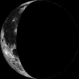
Moon Phase for October 23rd at Midnight
1.5 Days After Last Quarter
1.5 Days After Last Quarter
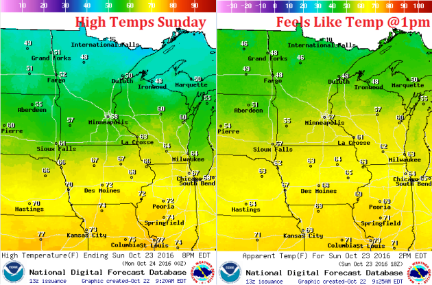
Weather Outlook Sunday
High
temperatures on Sunday will be cooler than what we had on Saturday.
Temperatures across the southern part of the state may sneak up into the
lower 60s once again, but most locations will be in the 40s and 50s.
High Temperatures From Average Saturday
High
temperatures on Saturday were nearly 5F to 10F above average, but the
passage of a cool front will allow temps to drop to more average levels
for mid/late October. Note that a few locations up north will even be a
little below average.

Weather Outlook Sunday
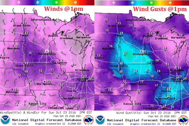
A
weak storm system will slowly push through the region on Sunday, which
in turn will prompt stronger winds across the state. Note that sustained
winds by midday will be around 10mph to 15mph with wind gusts
approaching 20mph to 25mph across the southern part of the state.
Weather Outlook Sunday
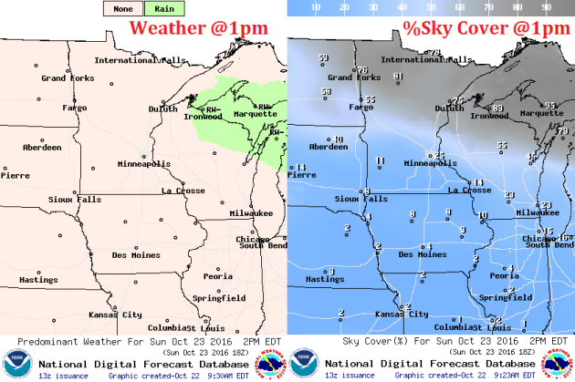
As
the weak storm system moves through the region, clouds and light spits
of rain will trickle across the northern part of Minnesota and
Wisconsin, while sunnier skies will be found to the south. Clouds and
light rain showers will help to keep temps in the 40s up north!
___________________________________________________________
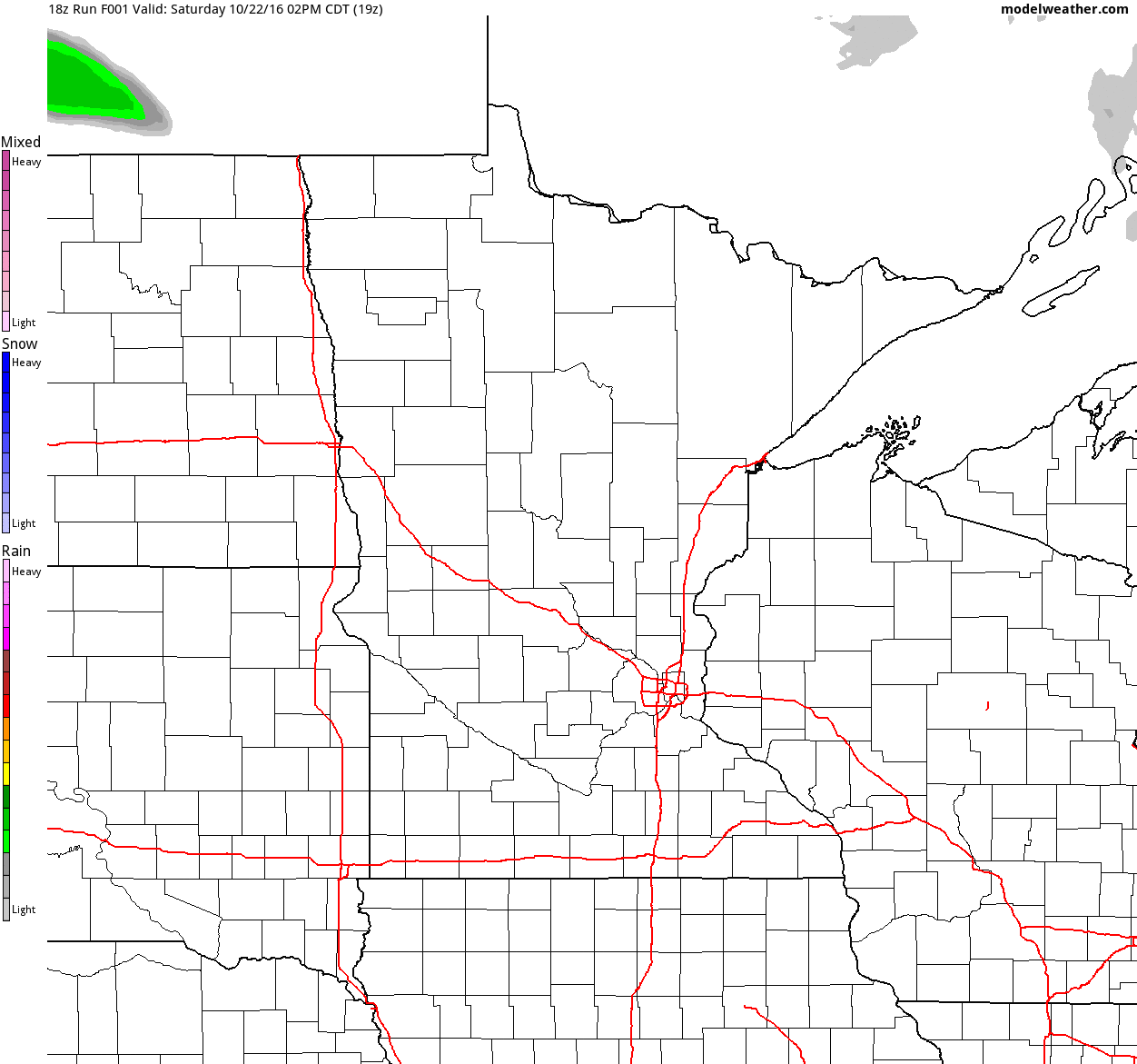
Simulated Radar
The
simulated radar from Saturday to Tuesday shows a few lingering showers
across the northern half as we head through Sunday, but amounts should
be very light. The next batch of rain won't come in until PM Tuesday.
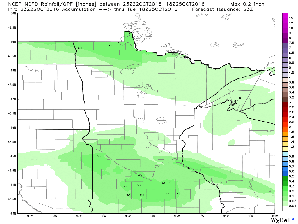
Rainfall Potential
Rainfall
potential through Monday shows mostly dry conditions across much of the
state, however, there could be some light tallies across the far north.
The next batch of rain will start to move in across the southern half
of the state PM Tuesday.
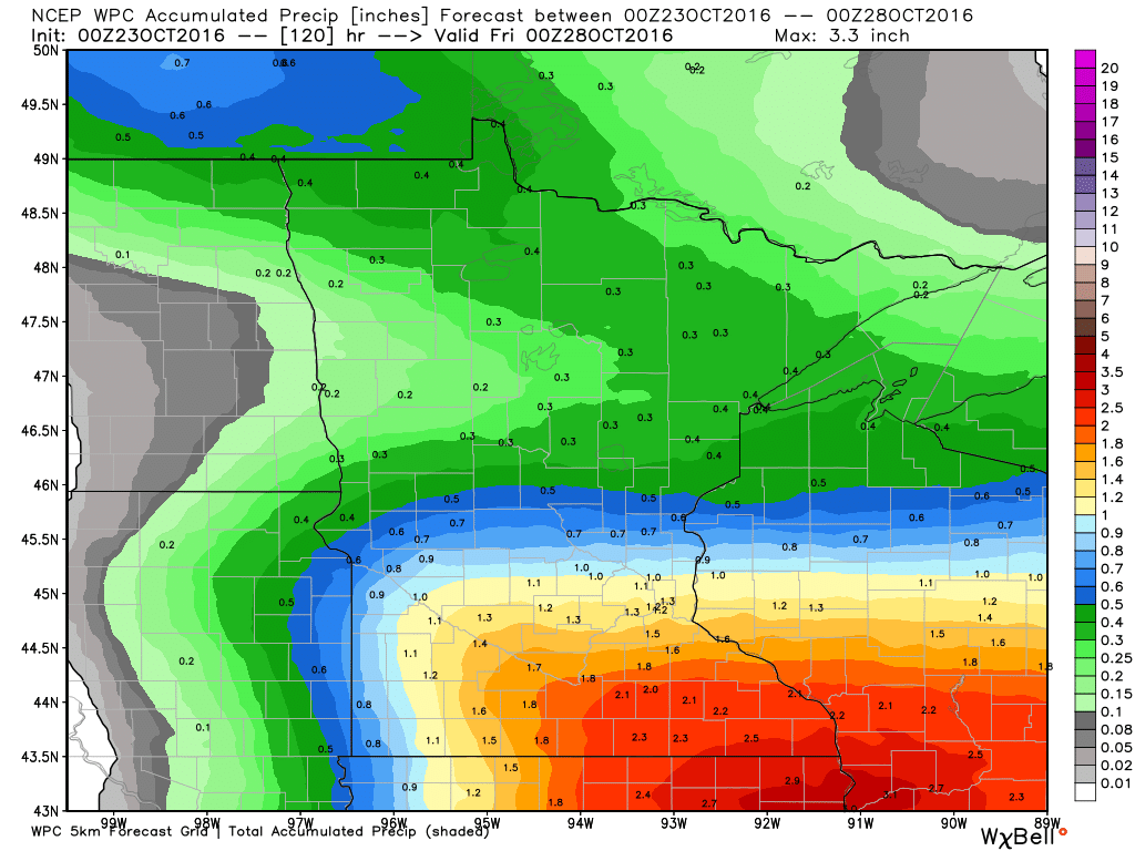
5 Day Rainfall Outlook
While
the rest of the weekend look mostly dry for most of the region, the
extended forecast is calling for some fairly decent accumulations.
According to NOAA's WPC, the 5 day rainfall forecast suggests some 1" to
2"+ rainfall tallies across the southern part of the state, most of
which will arrive Tuesday - Wednesday.
 _________________________________________
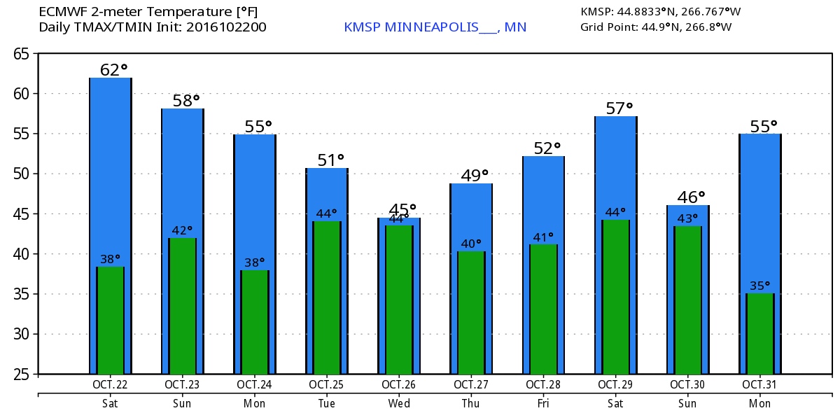
Extended Weather Outlook
The
extended temperature outlook over the next 10 days suggests a gradual
cooling trend over the next few days before bottoming out in the mid 40s
mid week. As we approach next weekend, temperatures look to rebound
back into 50s, which will be close to average once again.
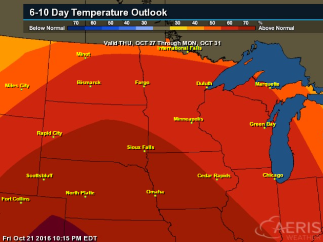
Warm Temperatures Return to Midwest
According
to NOAA's CPC, the 6 to 10 day temperature outlook suggests warmer than
average temperatures continuing across much of the Upper Midwest as we
approach the end of the month. It may be a mild Halloween this year...
stay tuned!
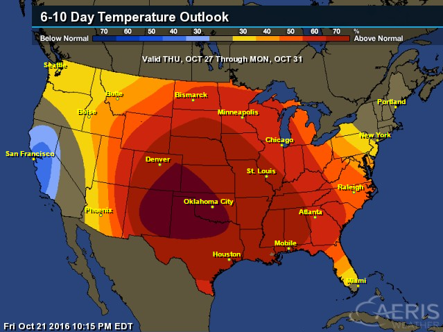
Here's
the national temperature outlook from October 27th - 31st, which shows
warmer than average conditions across much of the nation.
__________________________________________
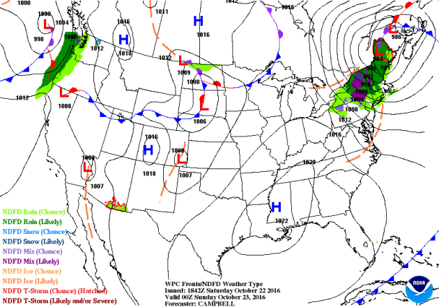
National Weather Outlook
A
large storm system in the Northern New England will continue to bring
heavier rain and lingering snow showers to parts of the Northeast
through the rest of the weekend. Meanwhile, an area of high pressure
will settle into the Upper Midwest early this week with more sun and
cool temps. Another storm system will settle into the Pacific Northwest
with more heavy wind and rain.
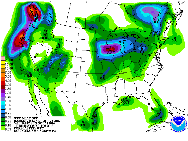
Precipitation Outlook
According
to NOAA's WPC, the next surge of heavy moisture along the West Coast
could bring some locations nearly 3" to 6"+ rainfall along the coast,
which could lead to some flooding. Also note the blob of heavier
precipitation in the Midwest, where some spots could see up to 2"+ rain
through midweek.
 _______________________________________________
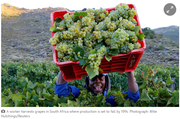
"Global wine production expected to fall by 5% due to 'climatic events'"
"South
America, particularly Argentina and Chile, likely to see biggest
decline, which may concern fans of wines such as malbec. Global wine
production is expected to fall by 5% in 2016 because of “climatic
events” causing steep drops in production in most of the southern
hemisphere, particularly Chile and Argentina. The International
Organisation of Vine and Wine (OIV) has estimated that output will reach
259.5m hectolitres (mhl) this year, making 2016 one of the lowest
production years in the past two decades. While the amount of wine
produced should meet consumer demand, the figures are a reminder of how
global warming and natural climate variability are having aprofound
effect on wine, and perhaps where it will be grown in future."
Thanks for checking in and don't forget to follow me on Twitter @TNelsonWX

No comments:
Post a Comment