First Snowfall of the Season for the Northeast
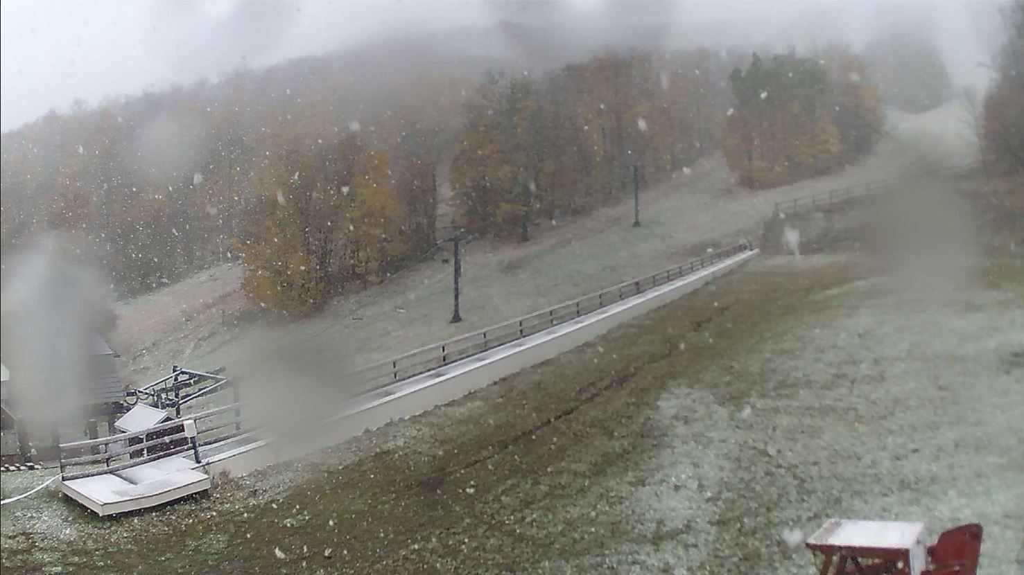
Snow was flying for the first time this season across parts of the Northeast this weekend. This was the view from Plattekill Mountain in New York on Saturday.
See the latest webcam from Plattekill Mountain HERE:
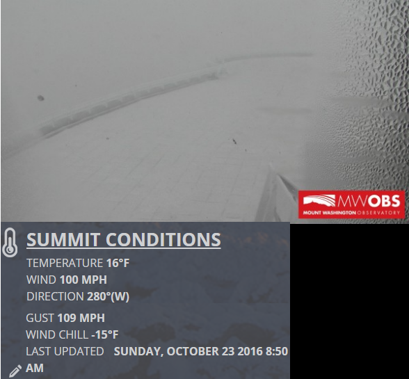
Mount Washington Observatory
While light snow was falling across some of the lower elevations in the Northeast this weekend, it was a whiteout at Mount Washington Observatory in New Hampshire at near 6,300ft. At approximately 9am EDT, the winds were gusting to near 110mph with a wind chilly of -15F !!
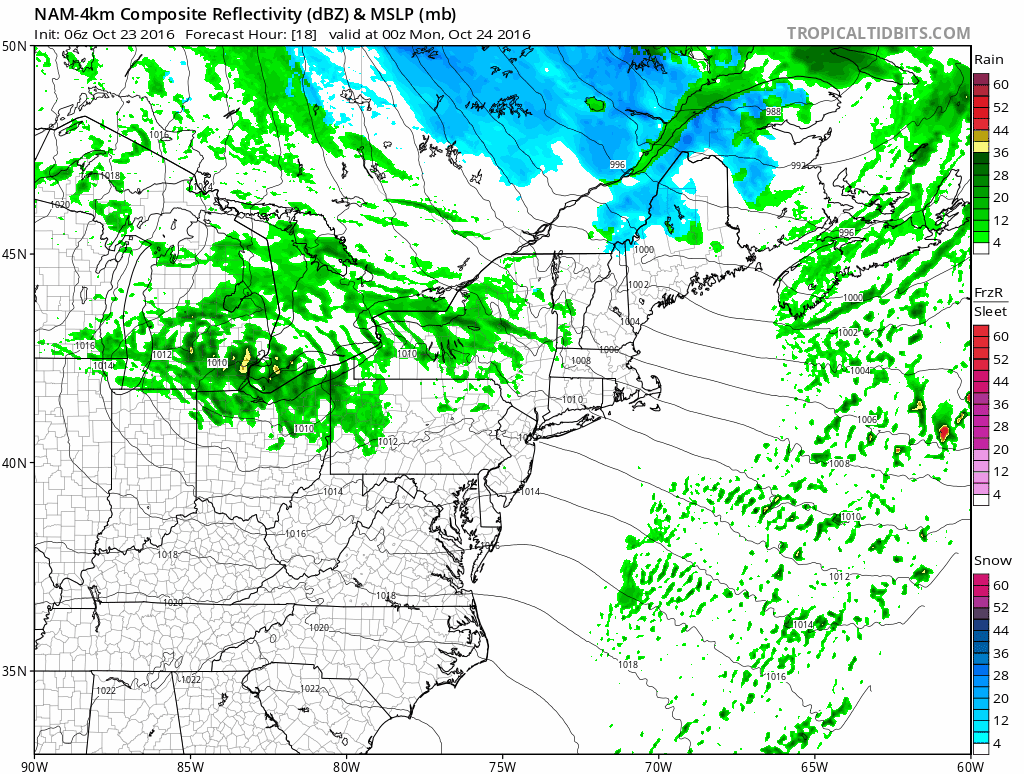
 Lingering Snowfall in the Northeast
A large storm system swirling in eastern Canada will continue to keep scattered rain and snow showers in the forecast through the early week time frame. Some of the heaviest snowfall accumulations will be found across the far north and in the highest elevations.
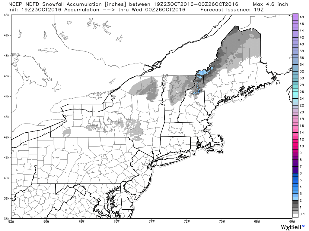
Additional Snowfall
Much of the snow from the weekend has tapered, but there still may be some additional snowfall through the early part of the week across the far north and high elevations.
_____________________________________________________________________________
Snow was flying for the first time this season across parts of the Northeast this weekend. This was the view from Plattekill Mountain in New York on Saturday.
See the latest webcam from Plattekill Mountain HERE:
Mount Washington Observatory
While light snow was falling across some of the lower elevations in the Northeast this weekend, it was a whiteout at Mount Washington Observatory in New Hampshire at near 6,300ft. At approximately 9am EDT, the winds were gusting to near 110mph with a wind chilly of -15F !!
A large storm system swirling in eastern Canada will continue to keep scattered rain and snow showers in the forecast through the early week time frame. Some of the heaviest snowfall accumulations will be found across the far north and in the highest elevations.
Additional Snowfall
Much of the snow from the weekend has tapered, but there still may be some additional snowfall through the early part of the week across the far north and high elevations.
_____________________________________________________________________________
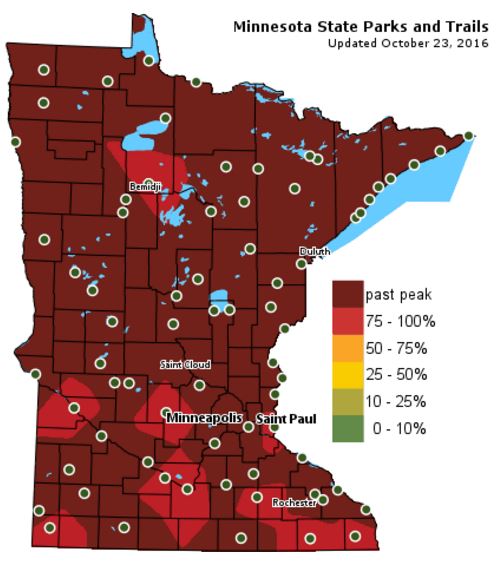
Fall Color Update
Colors are fading fast across the state with many locations already reporting past peak conditions. There are still a few spots across the southern part of the state that are currently peaking! This is certainly the weekend to get out and do a little leaf peeping!
Dry Monday - Heavier Rain in Southern MN TuesdayI feel like my wardrobe is in flux. I'm not sure what to wear from day to day. Chilly mornings, breezy winds, cloudy skies, afternoon sun, everything feels different in the fall.
Mother Nature will have us guessing again this week. Bright afternoon sun returns Monday, but a chilly rain moves in late Tuesday through Wednesday. I could see a few locations across southern Minnesota with 1 to near 2 inch rainfall tallies by midweek!
Drier weather settles in late week before another front plows south of the border late Friday. Temps take another hit this weekend with highs on Saturday struggling to make it into the 50s. I could see a few morning flurries across the northern part of the state again. The Twin Cities might even be close to their first official frost Sunday morning as temperatures fall into the low and mid 30s.
The extended forecast continues to call for warmer than average temps through the end of the month. No Halloween blizzards brewing. No significant cold snaps in sight.
Keep enjoying this mild Fall!
___________________________________________________
Extended Weather Outlook
SUNDAY NIGHT: Cloudy, then gradual clearing. Winds: NNW 5-10. Low: 37.
MONDAY: Chilly start, filtered PM sunshine. Winds: ESE 5-10. High: 55
MONDAY NIGHT: Increasing clouds. Winds: E 5. Low: 40.
TUESDAY: PM showers develop, heavier in southern Minnesota. Winds: ESE 10-15. High: 52
WEDNESDAY: Mostly cloudy with light spits. Winds: ENE 5-10. Wake-up: 42. High: 50
THURSDAY: Sun returns, a little warmer. Winds: SSW 5-10. Wake-up: 40. High: 56
FRIDAY: Winds pick up. Clouds increase late. Winds: W 10-20. Wake-up: 45. High: 60.
SATURDAY: Chilly. AM flurries up north? Winds: N 5-10. Wake-up: 40. High: 49.
SUNDAY: Nippy start. More PM Sun. Winds: S 10-15. Wake-up: 32. High: 52.
_______________________________
_______________________________
This Day in Weather History
October 24th
1922: A powerful low pressure system over Minnesota brings 55 mph winds to Collegeville.October 24th
________________________________
Average High/Low for Minneapolis
October 24th
Average High: 54F (Record: 80F set in 1989)
Average Low: 37F (Record: 15F set in 1887)
_________________________________
Average Low: 37F (Record: 15F set in 1887)
_________________________________
Sunrise/Sunset Times for Minneapolis
October 24th
October 24th
Sunrise: 7:41am
Sunset: 6:12pm
Sunset: 6:12pm
*Daylight Lost Since Yesterday: ~2mins & 55sec
*Daylight Lost Since Summer Solstice: ~5hours and 6mins
______________________________________________________________________
*Daylight Lost Since Summer Solstice: ~5hours and 6mins
______________________________________________________________________
Moon Phase for October 24th at Midnight
2.5 Days After Last Quarter
2.5 Days After Last Quarter
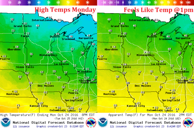
Weather Outlook Monday
High temperatures on Monday will be near average once again with highs in the 50s south and highs in the 40s north. Winds won't be quite as bothersome as they were on Sunday, but it they will help make it feel just a little cooler.
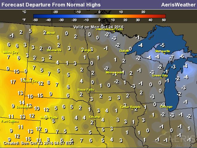
High Temperatures From Average Monday
High temperatures on Monday will be pretty close to where we should be at this time of the year across much of the Upper Midwest. Note that there appears to be quite a bit of warming across the Front Range of the Rockies and parts of the Plains, but this warmth won't make much of a push in our direction. We may see a little warming by Friday, but it will be short lived.
Weather Outlook Monday
An area of high pressure will settle in on Monday, which will help to keep winds much lighter than they were on Sunday. However, winds across the Dakotas will be much stronger.
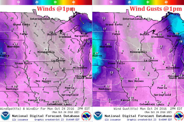
Weather Outlook Monday
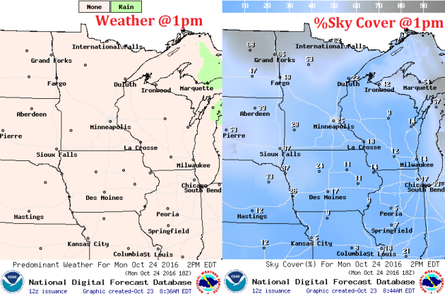
After a cloudier Sunday, bright sun returns on Monday. There will be some lingering cloud cover across the international border, but much of the region will enjoy some well deserved vitamin D.
___________________________________________________________
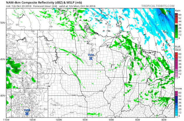
PM Tuesday - Wednesday Rain Potential
Here's our next storm system that will move through parts of the Midwest PM Tuesday - Wednesday. Note that the center of the storm looks to stay well south of Minnesota, which may help to limit heavy rain chances across the northern half of the state. The heaviest rain will likely be found across extreme southern Minnesota, northern Iowa and into southern Wisconsin.
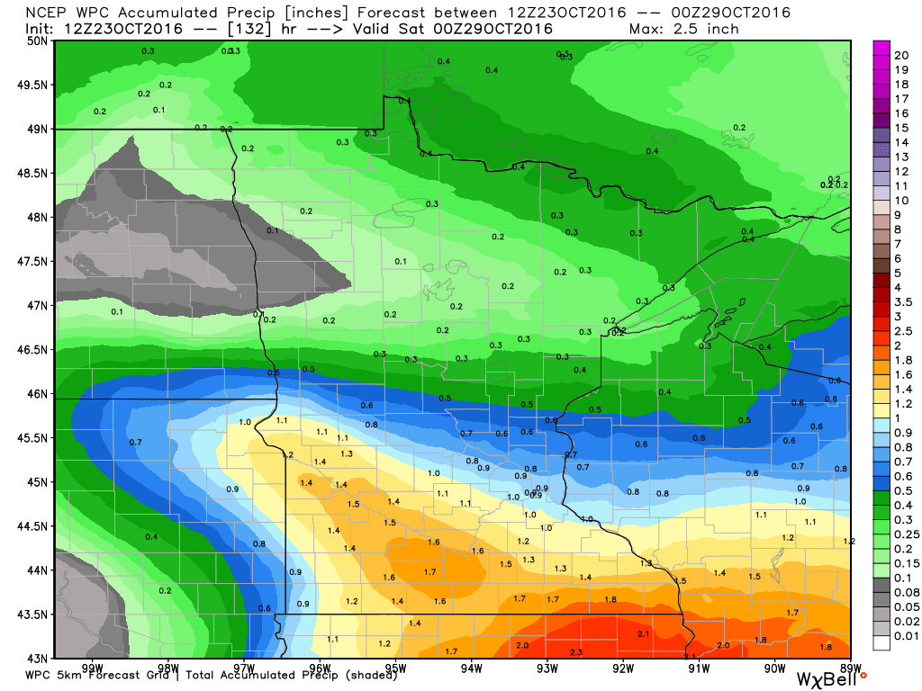
Rainfall Potential
The next batch of rain will start to move in across the southern half of the state PM Tuesday. Through PM Tuesday, some spots along the Minnesota River Valley could already be near 0.50" of rain.
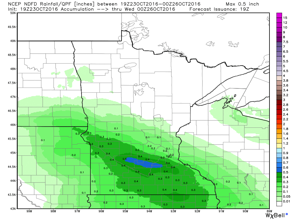
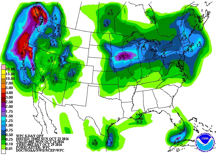
5 Day Rainfall Outlook
According to NOAA's WPC, the 5 day rainfall forecast suggests some 1" to 2"+ rainfall tallies across the southern part of the state, most of which will arrive Tuesday - Wednesday.
 _________________________________________
Extended Weather Outlook
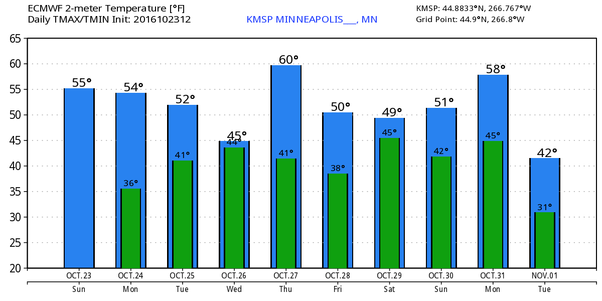
The extended temperature outlook over the next 10 days suggests a gradual cooling trend over the next few days before bottoming out in the mid 40s mid week. As we approach next weekend, temperatures look to rebound back into 50s, which will be close to average once again.
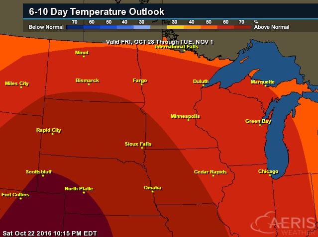
Warm Temperatures Return to Midwest
According to NOAA's CPC, the 6 to 10 day temperature outlook suggests warmer than average temperatures continuing across much of the Upper Midwest as we approach the end of the month. It may be a mild Halloween this year... stay tuned!
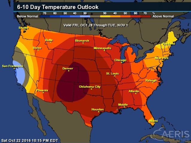
Here's the national temperature outlook from October 28th - November 1st, which shows warmer than average conditions across much of the nation.
__________________________________________
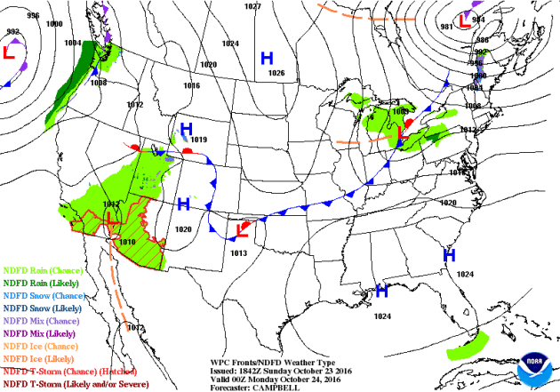
National Weather Outlook
A large storm system in the Northern New England will continue to bring lingering rain and snow showers to parts of the Northeast through the rest of the weekend. Meanwhile, an area of high pressure will settle into the Upper Midwest early this week with more sun and cool temps. Another storm system will settle into the Pacific Northwest with more heavy wind and rain.
Precipitation Outlook
According to NOAA's WPC, the next surge of heavy moisture along the West Coast could bring some locations nearly 3" to 6"+ rainfall along the coast, which could lead to some flooding. Also note the blob of heavier precipitation in the Midwest, where some spots could see up to 2"+ rain through midweek.
 ______________________________________________
"Climate change is shifting areas of skin disease concern"
"Reuters - Climate change is bringing certain skin diseases and other illnesses to regions where they were rarely seen before, according to a recent research review. Dermatologists should keep these changing patterns of skin diseases in mind when making diagnoses, say the authors, who analyzed specific disease shifts in North America. As the planet warms, many bacteria, viruses, fungi and parasites can survive in areas where they haven't been found before, the review team writes. In the U.S., for example, the incidence of the tick-borne Lyme disease increased from an estimated 10,000 cases in 1995 to 30,000 in 2013, and the area where it occurs keeps expanding from New England north into Canada as the ticks find their preferred habitat expanding. "In places like Canada, now there are ticks that carry Lyme disease farther north than doctors would ever expect to see that," Dr. Misha Rosenbach of the University of Pennsylvania in Philadelphia told Reuters Health said in a phone interview."See more from FoxNews.com HERE:

Thanks for checking in and don't forget to follow me on Twitter @TNelsonWX

No comments:
Post a Comment