40 F. maximum temperature yesterday at KSTC.
33 F. average high on November 26.
35 F. high on November 26, 2015.
November 27, 2005: In the early morning a home in Mower County is hit by lightning and burned to the ground, but no one is injured.
November 27, 1994:
A low pressure system produces the first winter storm of the season for
Minnesota. By the early morning hours of the 28th, a swath of snow in
excess of 6 inches had blanketed much of southwest through central into
northeast Minnesota. Snowfall of 6 inches or more occurred south of a
line from Gunflint Lake in Cook County to near Ortonville in Big Stone
County, and along and north of a line from near Blue Earth in Faribault
County to Red Wing in Goodhue County. The snow closed the
Minneapolis-St. Paul International Airport for a short time on the 27th,
and contributed to hundreds of accidents and at least three fatalities.
In addition, the build-up of ice and snow in combination with strong
winds resulted in numerous downed power lines in southeast Minnesota.
November 27, 1985: Extreme cold hits northern Minnesota. A low of 30 below zero is reported at Crookston.
November 27, 1971: Heavy snow falls in southwest Minnesota, with Redwood Falls receiving a foot.
 Exclusive Winter Outlook: "Colder With Some Snow"
My
11th grade advanced placement English teacher had good advice. "Use
action words. And when in doubt, mumble. Better yet, obfuscate."
I've been doing a lot of mumbling and random hand-waving in recent weeks when asked about the winter to come.
Weather
researcher Judah Cohen tracks Siberian snowcover in October to gauge
how tough winters will be in the U.S. Based on the rate of Russian snow
he predicts a weakened polar vortex capable of lobbing arctic air
southward; coldest conditions east of the Rockies. Not as cold as 3
winters ago - but close. NOAA is studying Cohen's research but it
doesn't factor Siberian snowcover into its winter outlook.
I suspect it
will be colder and snowier than last winter as freakish warming of the
arctic throws the jet stream off the rails, again.
Rain arrives
tonight with puddles lingering into
Monday
as showers taper. A coating of light snow is possible the latter half
of the week, but no headline-grabbing storms are brewing into next week.
Enjoy 40s, because the first half of December will be a poignant
reminder that we live (way) 'up north.
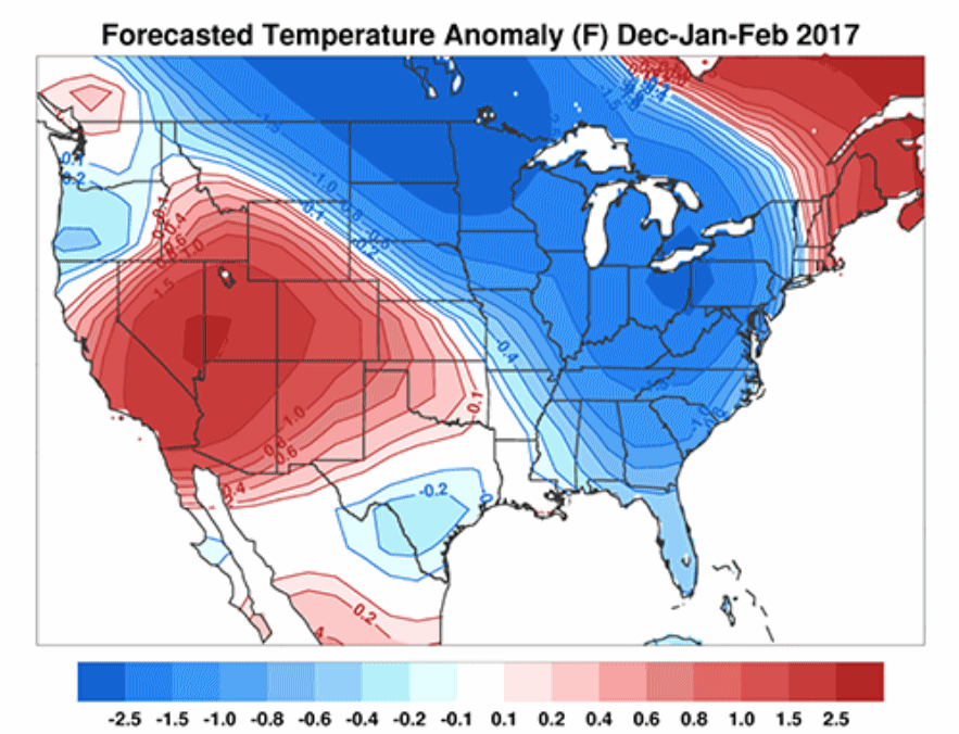
Map credit above: "
Predicted
winter surface temperature anomalies for the United States Dec-Jan-Feb
2016/17 in degrees Fahrenheit. The model is forecasting colder than
normal temperatures for much of the Eastern United States with warmer
than normal temperatures for the Western United States. The model uses
October Siberian snow cover, sea level pressure anomalies, predicted El
Niño/Southern Oscillation anomalies, observed September Arctic sea ice
anomalies, and the predicted winter value of the Pacific Decadal
Oscillation. October Siberian snow cover advanced at an above normal
rate during the entire month. This is an indication of an increased
probability of a weakened polar vortex or a sudden stratospheric warming
and a predominantly negative Arctic Oscillation during the winter, and
cold temperatures, especially east of the Mississippi. This is the most
recent forecast using the full monthly values for snow cover and sea
level pressure anomalies." Forecast date: November 14, 2016.
Credit: Judah Cohen. More information at
The National Science Foundation.
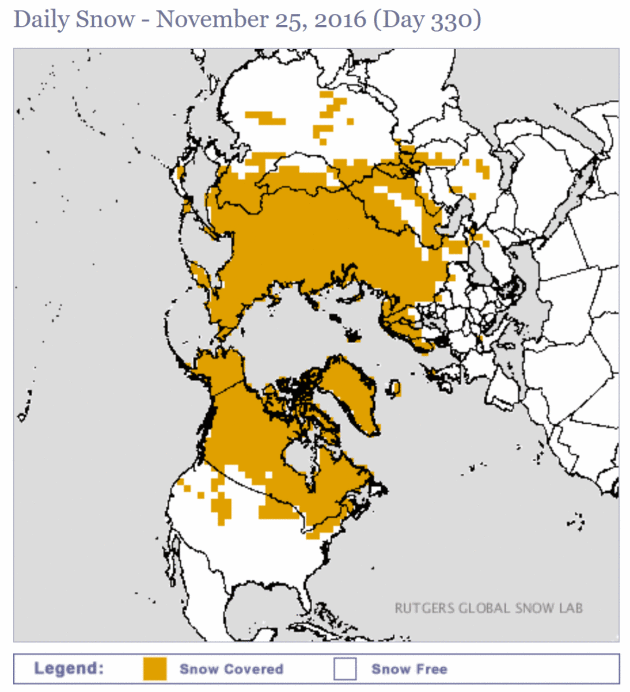
From Russia, With Snow. How Siberian Weather Predicts U.S. Winter.
USA TODAY has an article with more detail on how Judah Cohen uses Russian snowcover to predict the winter to come: "...
Here's
how: Snow reflects about 70% to 80% of the sun's warmth back into
space, while a bare ground reflects only 20%. October is when Siberia
and the entire Eurasian region sees its greatest expansion of snow
cover, sometimes increasing as much as six million square miles, larger
than the total land area of the U.S., including Alaska. Just how
snow-covered Siberia gets in fall helps Cohen formulate his forecast
because that icy cold air over the region will slowly slosh into Europe
and eventually into North America by mid-winter. Essentially, more snow
in Siberia equates to colder air and the potential for more snow than
normal in the U.S..." (Map credit: Rutgers
Global Snow Lab).
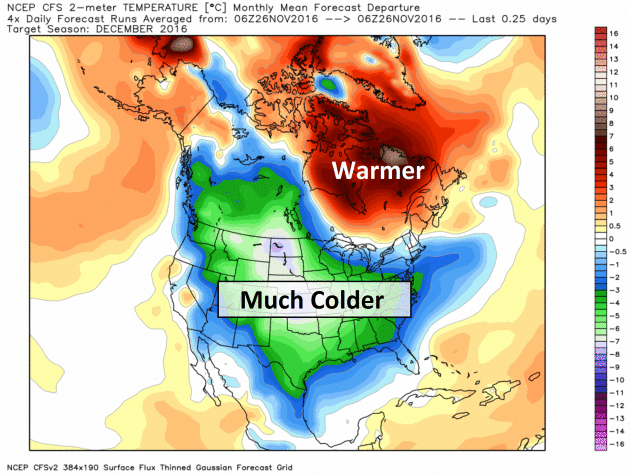
On-Again, Off-Again (Frigid) December?
NOAA's CFSv2 climate model keeps flip-flopping between mild and cold
solutions for December; the latest outlook calls for 8-12F colder than
average for much of the USA. Map: WeatherBell.
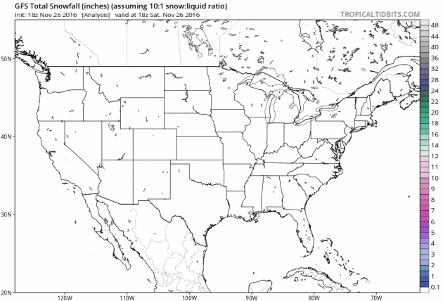
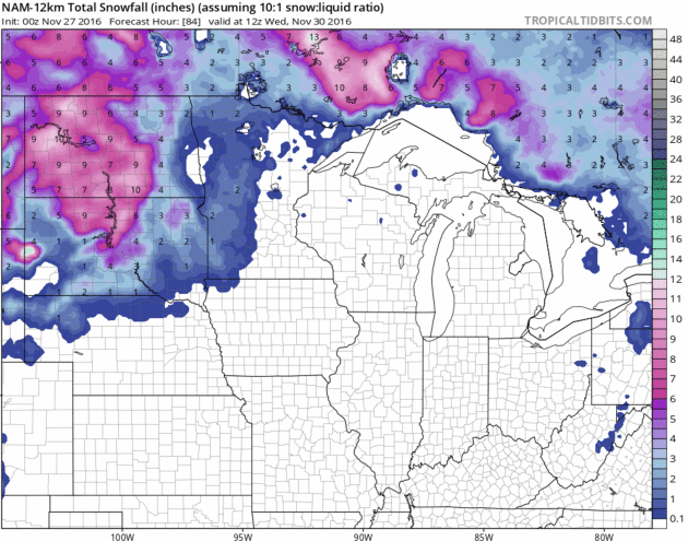
10-Day Snowfall.
Plowable (3"+) snowfalls are likely across northern New England, North
Dakota, the Panhandle of Texas and much of New Mexico, as well as over
western mountains, where the maps are definitely looking like winter.
240-hour GFS snowfall product: TropicalTidbits.com
Warm Enough For Rain.
The vast majority of the next storm tonight and Monday falls in liquid
form across Minnesota; an inch or two of slushy accumulation for the
western third of Minnesota by midweek. More significant 5-9" amounts are
predicted across the Dakotas.
Still Above Average.
The crazy-warmth of early November is history, but temperatures run
above average the next 10 days; peaking Monday as a strong storm pulls
mild air into Minnesota. We cool back down to average the latter half of
next week. MSP predicted highs/lows from ECMWF courtesy of WeatherBell.
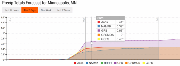
Soaking Rain Overnight.
NOAA models print out anywhere from .32" to .68" for the Twin Cities
tonight into Monday morning. Had the mercury been 10-15F colder that
would have translated into 4-8" snow.
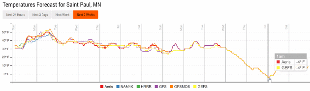
First Subzero for MSP?
Confidence levels are low, but GFS ensembles predict the first subzero
low Friday morning, December 9. Something to look forward to. Source:
Aeris Enterprise.
Mid-December: Cold, Not Frigid.
By the second week of December GFS guidance is hinting at more of a
"modified-zonal" west-to-east wind patttern for the USA; the coldest air
bottled up over Canada. It will be interesting to see if polar vortex
winds really do relax (consistently), allowing a flow of bitter air into
January and early February. The jury is still out.
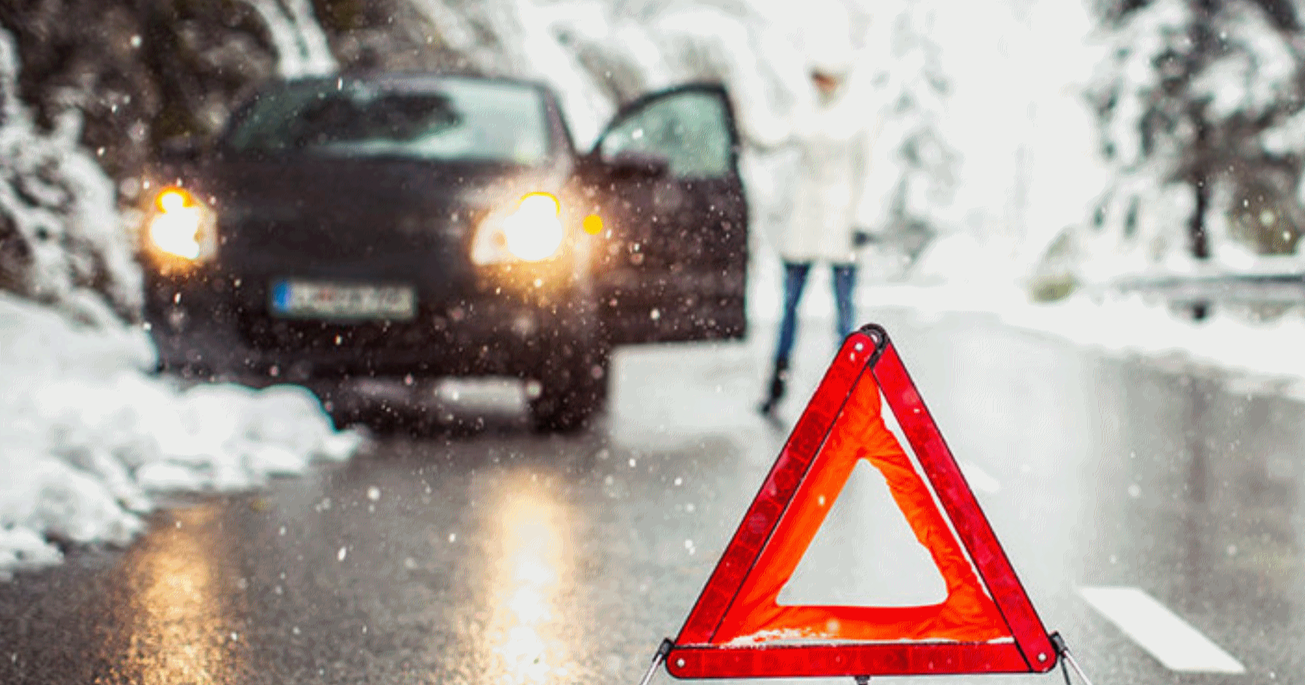 Winter Weather Accident Statistics
.
For me the most important lesson in all of this is to force myself to
slow down. Many of us still drive way too fast for conditions. Here's an
excerpt from
thezebra.com: "
According
to the Federal Highway Administration, 70 percent of the nation’s roads
are located in snowy regions—in other words, anywhere that receives
more than five inches of snowfall each year, on average. In addition,
nearly 70 percent of the U.S. population lives in these snowy regions.
In other words? A lot of us have to deal with winter storms. And about 70 percent of the accidental deaths that occur in the wintertime happen in automobiles.
Other Sobering Stats (from the folks at SafeWinterRoads.org:
- Over
1,300 people are killed and more than 116,800 people are injured in
vehicle crashes on snowy, slushy or icy pavement annually.
- Every year, nearly 900 people are killed and nearly 76,000 people are injured in vehicle crashes during snowfall or sleet..."
 November Nuggets
. Here are a few factoids regarding the abnormally mild start to November across the USA, courtesy of
Planalytics: "
Nationally, it was the warmest 3rd week of November in 55+ years. Cooler temperatures were focused in the South Atlantic region. Despite the late week snowstorm, the third week of November recorded the least snow and rain since 2012..."
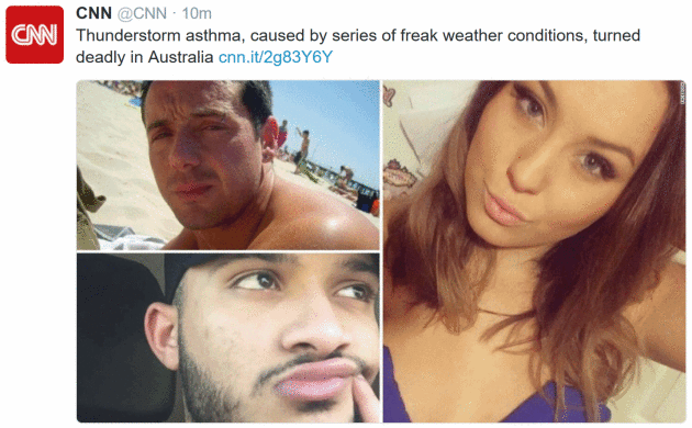
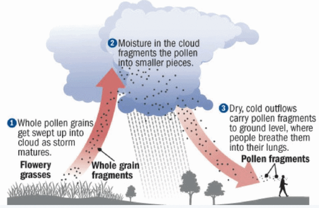
Australia's Bizarre Outbreak: "What Is Thunderstorm Asthma?" This is the first I heard of this phenomenona, explained at Live Science: "...It's
thought that these outbreaks occur because, during thunderstorms,
pollen grains rapidly absorb water and rupture, leading to the release
of hundreds of small particles into the air, ASCIA says. These particles
can penetrate deep into people's lungs and trigger asthma attacks,
ASCIA says. Some outbreaks of thunderstorm asthma have also been linked
with increased levels of fungal spores in the air. It's also thought
that gusty winds in thunderstorms help to spread pollen particles and
other allergy-inducing substances. A 2008 study
that looked at emergency room visits in Atlanta over a 10-year period
found that there were 3 percent more visits for asthma on days following
thunderstorms. The link between asthma visits and thunderstorms was
strongest when the wind gusts during the storm were intermediate to
high, the study found..."
 Enlightening
. Thanks to Vasin Lee and Shutterstock.com for passing this one along.
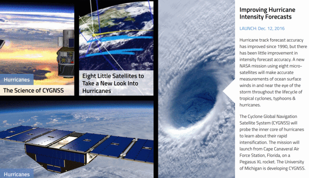
Improving Hurricane Intensity Forecasts. Launch is set for December 12. Here's more detail and clarity on what the mission entails from
NASA: "
Hurricane
track forecast accuracy has improved since 1990, but there has been
little improvement in intensity forecast accuracy. A new NASA mission
using eight micro-satellites will make accurate measurements of ocean
surface winds in and near the eye of the storm throughout the lifecycle
of tropical cyclones, typhoons & hurricanes. The Cyclone Global
Navigation Satellite System (CYGNSS) will probe the inner core of
hurricanes to learn about their rapid intensification. The mission will
launch from Cape Canaveral Air Force Station, Florida, on a Pegasus XL
rocket. The University of Michigan is developing CYGNSS..."
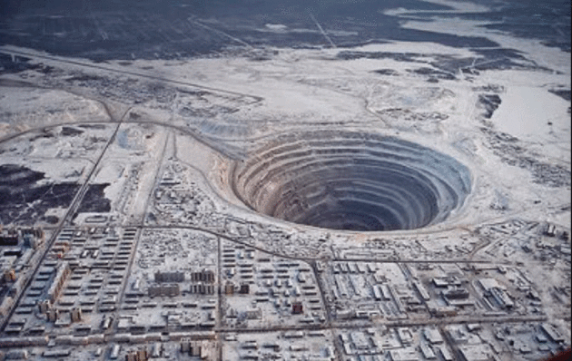
Russian Scientists May Have Found Geological Evidence of "Noah's Flood". I'm skeptical, but who knows - maybe it's real? Here's an excerpt from
Nature World News: "
New
scientific evidence may disprove all that we know about the earth and
its layers. We have been taught since childhood that the earth becomes
denser as a measuring point comes nearer the core. However, what Russian
scientists have discovered may prove this otherwise. The Kola
Borehole is a very lengthy drill hole, where samples of soil as deep as
12 kilometers into the earth's crust have been collected. According to
experts, the soil will become denser as the drill goes deeper into the
earth; however, they found interesting evidence that may change what we
all have believed in..."
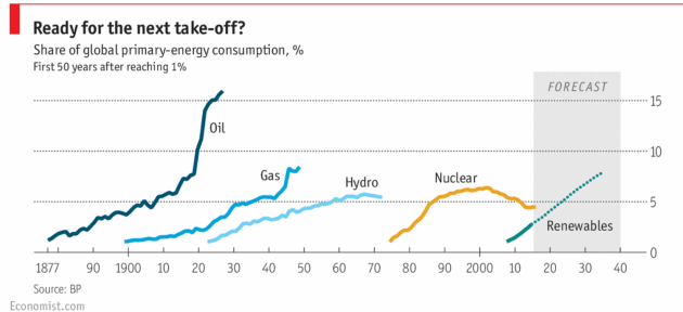
The Future of Oil. The Economist takes a look at a possible inflection point for fossil fuels; here's a clip: "...
Yet
the transition from horse power to horsepower, a term coined by Eric
Morris of Clemson University, South Carolina, is a useful parable for
our time. A hundred years ago oil was seen as an environmental saviour.
Now its products are increasingly cast in the same light as horse manure
was then: a menace to public health and the environment. For all its
staying power, oil may be facing its Model T moment. The danger is not
an imminent collapse in demand but the start of a shift in investment
strategies away from finding new sources of oil to finding alternatives
to it. The immediate catalyst is the global response to climate change.
An agreement in Paris last year that offers a 50/50 chance of keeping
global warming to less than 2ºC above pre-industrial levels, and perhaps
limiting it to 1.5ºC, was seen by some as a declaration of war against
fossil fuels..."
Pressure Mounts to Reform Our Throwaway Clothing Culture.
What does sustainable capitalism look like? How can we have everything
we want, but put exponentially less strain on Earth's operating system?
Here's an excerpt from
Yale Environment 360: "...
Eileen
Fisher, the founder of the apparel company that bears her name, has
called the clothing industry “the second largest polluter in the world,
second only to oil,” a claim that can’t be verified because reliable
data on fashion’s global footprint is scarce. But there’s no doubt that
vast amounts of water, energy, and chemicals are required to manufacture
clothes — up to 200 tons of water, for example, to make a ton of
fabric, according to the Natural Resources Defense Council.
In places where environmental regulation is lax, chemicals are
routinely discharged into rivers and streams without treatment. The
textile industry has long been one of China’s biggest polluters, and it
has fouled rivers and ruined farmland in India, Cambodia, and
Bangladesh, as well..."
Illustration credit: Luisa Rivera for Yale E360.
Hot Tech Gifts.
The New York Times highlights a few gift ideas for the techno-geek in your life: "
It
is often daunting to sort through the newest technology products to
find something fitting for your gadget-savvy family and friends. Fret
not: Here are some of the most useful and entertaining tech gifts of the
year..."
SUNDAY: Mild with increasing clouds. Showers by late afternoon or evening. Winds: SE 8-13.
High: 47
SUNDAY NIGHT: Rain, heavy at times. Low: 45MONDAY: Showers linger, wet roads. Winds: S 10-20. High: 50 (early, then falling)
TUESDAY: Light rain/snow mix. Winds: SW 10-15. Wake-up: 36. High: near 40
WEDNESDAY: Coating of light snow possible. Winds: NW 10-20. Wake-up: 33. High: 38
THURSDAY: Clouds linger, more flurries - slick spots. Winds: NW 10-20. Wake-up: 30. High: 37
FRIDAY: Chilly holding pattern, more flakes. Winds: NW 10-15. Wake-up: 30. High: 38
SATURDAY: Peeks of sun, flurries hang on - seasonably chilly. Winds: W 8-13. Wake-up: 29. High: 37
Climate Stories...
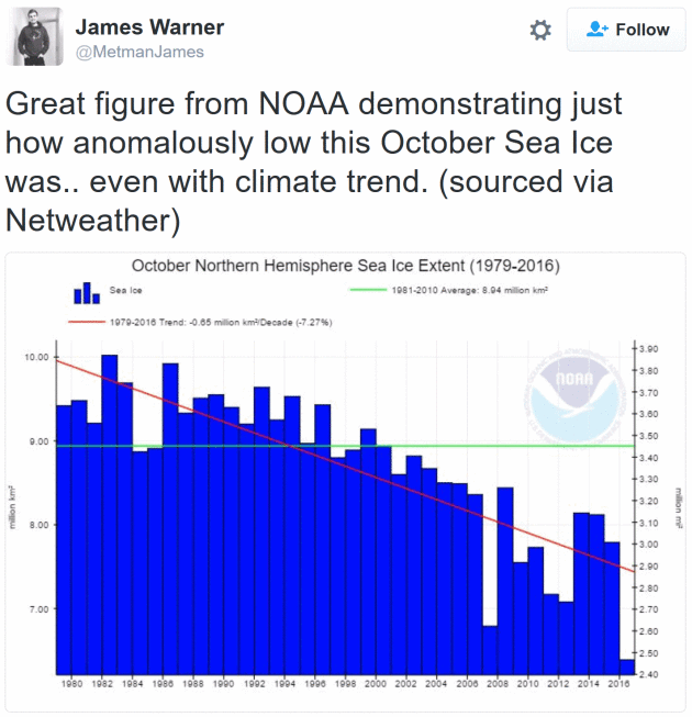
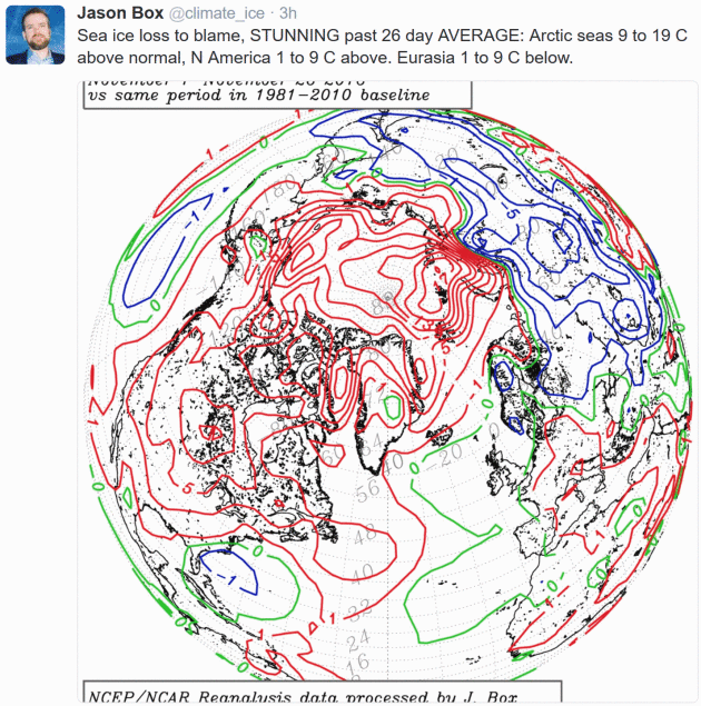
Arctic Ice Melt Could Trigger Uncontrollable Climate Change at Global Level. Are we close to a tipping point in the Arctic? Here's an excerpt from
The Guardian: "
Arctic
scientists have warned that the increasingly rapid melting of the ice
cap risks triggering 19 “tipping points” in the region that could have
catastrophic consequences around the globe. The Arctic Resilience Report
found that the effects of Arctic warming could be felt as far away as
the Indian Ocean, in a stark warning that changes in the region could
cause uncontrollable climate change at a global level. Temperatures in
the Arctic are currently about 20C above what would be expected for the time of year, which scientists describe as “off the charts”. Sea ice is at the lowest extent ever recorded for the time of year..."
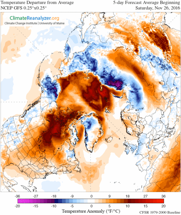
5-Day Predicted Temperature Anomalies:
Climate Reanalyzer.
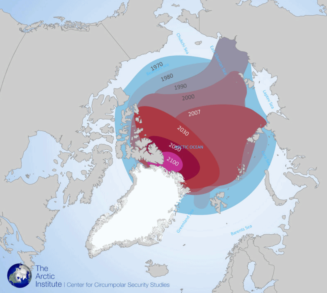 Full Speed Ahead: Shipping Plans Grow As Arctic Ice Fades
. Here's an excerpt of a head-shaking article at
Yale Environment 360: "...
Russia
is farther ahead than any other country in exploiting Arctic shipping
opportunities. It has more icebreakers by far than any other nation — 40
— and more Arctic ports. (Canada and the United States have no
significant ports on the Arctic Ocean.) To further boost the development
of new shipping routes, Russia’s State Commission on Development of the
Arctic Regions convened in Moscow last April to establish a single
company that will oversee all logistical operations in the Arctic region
and coordinate the activities of various levels of government..."
Map credit: "
Past and projected summer sea ice decline in the Arctic" The Arctic Institute.
West Antarctic Is In Huge Trouble. But Now Scientists Say The Problem May Date Back to 1945. Chris Mooney has the story at
The Washington Post: "
Science
likes to surprise us. That’s the extraordinary, mind-opening thing
about it. It’s possible that is now happening with one of the most
stunning stories yet in the climate change saga — the finding that the
enormous glaciers of West Antarctica appear to be retreating in an “unstoppable” way.
It’s a process which, if it continues, could ultimately turn the West
Antarctic ice sheet into an area of wide open ocean and raise global sea
levels by 10 feet. It has long been assumed that this destabilization
of West Antarctica was caused by human-induced climate change. However,
a new study published in the journal Nature Wednesday may have just made that story considerably more complicated..."
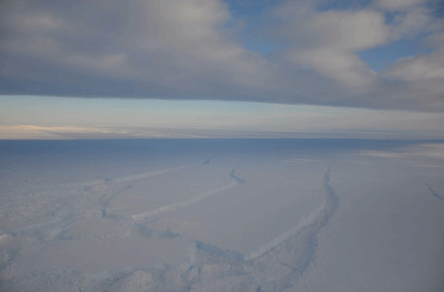
Photo credit: "
Crevasses on Pine Island Glacier." (J Smith.)
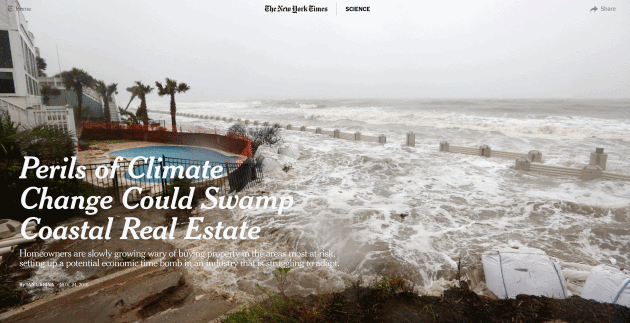
Perils of Climate Change Could Swamp Coastal Real Estate. Here's a link and excerpt from
The New York Times: "
Real
estate agents looking to sell coastal properties usually focus on one
thing: how close the home is to the water’s edge. But buyers are
increasingly asking instead how far back it is from the waterline. How
many feet above sea level? Is it fortified against storm surges? Does it
have emergency power and sump pumps? Rising sea levels are changing the
way people think about waterfront real estate. Though demand remains
strong and developers continue to build near the water in many coastal
cities, homeowners across the nation are slowly growing wary of buying
property in areas most vulnerable to the effects of climate change..."
Photo credit: "Waves crashing over an experimental sea wall built to protect homes during high tide in Isle of Palms, S.C., last year." Credit Mic Smith/Associated Press.
2016 Breaking Records In All The Wrong Places. CleanEnergy Footprints
has a rundown on some of the most jaw-dropping weather of 2016; events
that may have been amplified and magnified by a warmer, wetter climate,
according to WMO (World Meteorological Organization): "...
Numerous
extreme weather events caused catastrophic impacts to people around the
world, including Hurricane Matthew and Typhoon Lionrock; major floods in
the Yangtze basin, Sri Lanka, and the Niger River basin; extreme heat
waves in Southern and Northern Africa and the Middle East; the Alberta
wildfire; and Southern African drought. Together these extreme weather
events killed at least 1,000 people, destroyed or severely crippled
thousands of people’s homes and livelihoods, caused tens of billions of
dollars worth of damage, and are expected to contribute to millions of
people’s famine and displacement. A separate WMO report
released last week showed that of 79 studies about extreme weather
events published by the Bulletin of the American Meteorological Society
between 2011 and 2014, more than half found that human-induced climate
change contributed to the extreme event in question..."
Meteorologist Tells Christians: Climate Change Is Real. More on our outreach to conservatives and evangelicals at
Opposing Views: "...
David
Konisky of Georgetown University and Matthew Arbuckle of the University
of Cincinnati studied the "religiosity" of Catholics, Protestants and
Jews, and how their faith affected their environmental views. Konisky
and Arbuckle wrote in their study, "Individuals that affiliate with an
Evangelical Protestant church, all else equal, are less likely than both
Mainline and Protestant churches to be worried about climate change."
The study also found that Christians who believe the Bible is the
literal word of God "are less likely to express high degrees of concern
about the environment..."
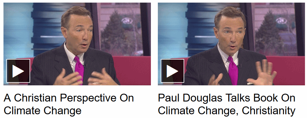 Meteorologist Paul Douglas Hopes To Bridge Christian Climate Change Debate
. My thanks to Jean Hopfensperger at
The Star Tribune for the review: "
The
book, entitled “Caring for Creation: An Evangelical’s Guide to Climate
Change and a Healthy Environment,” hit the bookstores this month. It is
co-authored by the Rev. Mitch Hescox, president of the Evangelical
Environmental Network. “I figured if people didn’t want to hear from
scientists, maybe they’d listen to a minister and a meteorologist,” said
Douglas. The book constructs the debate around evangelical values: It
is the “personal responsibility” of Christians to protect God’s
creation. It is “pro-life” because it is protecting children from
illnesses from autism to asthma, as well as protecting all life on Earth..."


It's really amazing article !!! Here it is so discussed about it. Thanks for sharing the complete details about this. If you want to know about asthma, you can visit this site https://dailylifedose.com/asthma-symptoms-causes-cure/
ReplyDelete