Active Weather Continues...
Here's the weather outlook from Friday to Friday of next week. Quiet weather looks to continue through the early week time frame, but a storm system arrives late Sunday through early next week. Heavier rain will change to snow by the middle part of the week.
.gif)
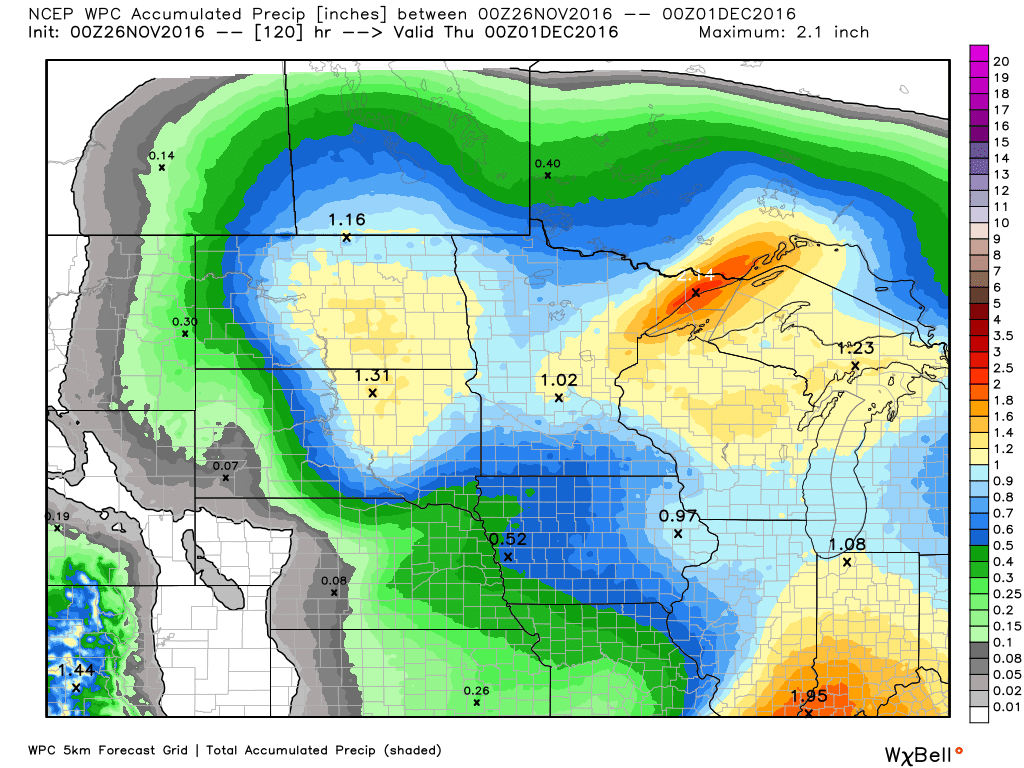
5 Day Precipitation Outlook
Here's the 5 day precipitation outlook thru thru the middle part of next week. Note that many locations will see up to 1" of liquid through then.
5 Day Snowfall Potential
As our next storm system moves into the region, cold air on the western side of the storm will help to produce snow across the Dakotas. Note that the heaviest looks to fall over North Dakota with some 6"+ tallies possible. Meanwhile, much of Minnesota will see lighter

______________________________________________________________________________
"October extinguished itself in a rush of howling winds and driving rain and November arrived, cold as frozen iron, with hard frosts every morning and icy draughts that bit at exposed hands and faces" wrote J.K. Rowling, in "Harry Potter and the Order of the Phoenix".
November is a dark, cruel month. Many find it hard to be thankful for emboldened cold fronts, long shadows and a sun that is AWOL much of the time. Then again we're counting down to holidays, more time with family, less yard work and fewer mosquitoes.
We get to remove one layer of clothing Saturday as the mercury pushes into the 40s. Rain arrives late Sunday and Sunday night, tapering to showers Monday. It should be cold enough for a snowy coating the middle of next week. I don't see a snow day, not yet. But NOAA's GFS model does try and spin up a more formidable storm late next week.
After 3 Septembers in a row the atmosphere was primed for a little payback. No record cold is brewing, nothing I'd qualify as frigid. Just a reminder that we live in a distant southern suburb of Winnipeg, Manitoba. It's true.
___________________________________________________
Extended Weather Outlook
FRIDAY NIGHT: Patchy cloudy with patchy fog developing. Winds: SW 5. Low: 27
SATURDAY: Peeks of sun, a bit milder. Winds: SE 7-12. High: 40.
SATURDAY NIGHT: Partly cloudy and quiet. Winds: ESE 5. Low: 30.
SUNDAY: Clouds increase, rain likely Sunday evening and night. Winds: SE 10-15. High: 47
MONDAY: Showery rains, turning colder. Winds: SE 10-20. Wake-up: 42. High: 46, then falling
TUESDAY: Light mix, a little slush. Winds: W 10-15. Wake-up: 36. High: 41
WEDNESDAY: Flurries linger, light coating. Winds: W 10-15. Wake-up: 30. High: 36
THURSDAY: More flurries, feels like November. Wake-up: 28. High: 35.
FRIDAY: Rare sunshine sighting? Chilly. Wake-up: NW 7-12. Wake-up: 27. High: 37.
_______________________________
_______________________________
This Day in Weather History
November 26th
2001: A strong low pressure system develops in Colorado on the 25th, reached eastern Iowa during the evening of the 26th, then moved into eastern Wisconsin late on the 27th. It produced a wide swath of heavy snow across much of central Minnesota into West Central Wisconsin. Storm total snowfall of 8 inches or more was common, with a large area exceeding 20 inches. Specifically, Willmar picked up 30.4 inches, New London saw 28.5 inches, Collegeville had 23.4 inches, Litchfield and Granite Falls received 22 inches, and Milan had 20 inches. A convective snow band set up across this area on the 27th and remained nearly stationary for over 12 hours, resulting in the extreme storm totals. From 8 am on the 26th to 8 am on the 27th, Willmar received 21 of its 30.4 inches, setting a record for most snowfall in Willmar in a 24 hour period. The heavy wet snow downed numerous power lines, and at one point, at least 20,000 customers were without power in the Minneapolis-St. Paul metropolitan area. Over one thousand traffic accidents were noted across the entire area. Most were minor, but one accident claimed two lives when a car spun out and collided with a semi near Mora.November 26th
1995: A narrow band of five to eight inches of snow falls from west central Minnesota around Canby and Granite Falls to east central Minnesota. This included much of the Twin Cities metro area.
1965: A snowstorm develops across northern Minnesota. 14.7 inches of snow fell at Duluth, along with 13.6 inches at Grand Rapids.
1896: A severe Thanksgiving day ice storm develops over southwest and central Minnesota. 1.42 inches of freezing rain falls at Bird Island, and 1.20 inches of freezing rain falls at Montevideo. The ice causes a great deal of damage to trees and shrubs.
________________________________
Average High/Low for Minneapolis
November 26th
Average High: 35F (Record: 62F set in 1914)
Average Low: 20F (Record: -16F set in 1977)
Average Low: 20F (Record: -16F set in 1977)
Record Snowfall: 5.9" set in 2001
_________________________________
_________________________________
Sunrise/Sunset Times for Minneapolis
November 26th
November 26th
Sunrise: 7:25am
Sunset: 4:35pm
Sunset: 4:35pm
*Length of Day: ~9hours & 9mins
*Daylight Lost Since Yesterday: ~1mins & 48sec
*Daylight Lost Since Summer Solstice: ~6hours and 26mins
______________________________________________________________________
*Daylight Lost Since Yesterday: ~1mins & 48sec
*Daylight Lost Since Summer Solstice: ~6hours and 26mins
______________________________________________________________________
Moon Phase for November 25th at Midnight
3.2 Days Before New Moon
3.2 Days Before New Moon

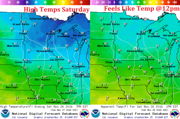
Weather Outlook Saturday
High temps on Saturday will warm up quite a bit across the region with highs across the state of MN in the 30s and 40s nearly 5F to 15F above average.
High Temperatures From Average Saturday
Here's a look at high temperatures from average on Saturday, which shows MUCH warmer than average conditions across much of the Upper Midwest. Note that the warmest readings will be across the Central and High Plains, where readings there will be nearly 10F to 20F above average.

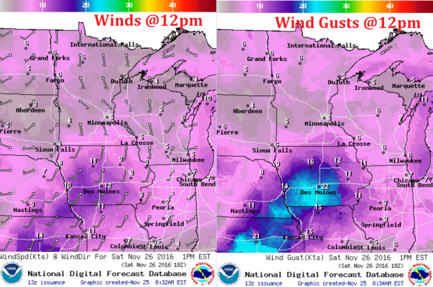
Weather Outlook Saturday
Winds on Saturday will be light once again. Note that the wind direction will be more southerly, which will help to keep warmer than average temperatures in place through the day.
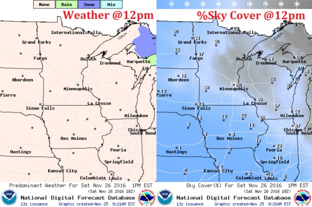
Weather Outlook Saturday
Weather conditions on Saturday look very quiet. No precipitation is expected and it appears that we may even sneak in some sunshine across the regions, especially later in the day.
___________________________________________________________
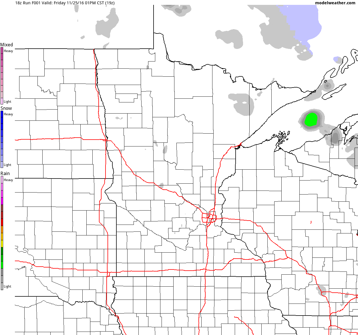
Simulated Radar
The simulated radar from Friday to Monday shows mostly quiet weather across much of the region through the early half of the weekend, but rain moves in late Sunday through Monday. Keep in mind that some of the rain could be heavier at times across the region.
_______________________________________
Extended Weather Outlook
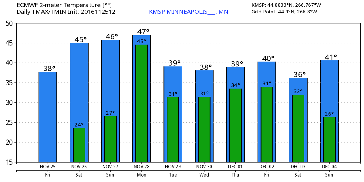
The temperature outlook for Minneapolis into the early part of December shows a warm up into the mid/upper 40s this weekend and Monday before temperatures return to near normal levels for much of next week.
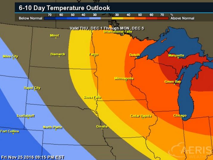
Warm Temperatures Return to Midwest
According to NOAA's CPC, the 6 to 10 day temperature outlook suggests warmer than average temperatures across much of the Upper Midwest and Great Lakes as we head into the first few days of December.
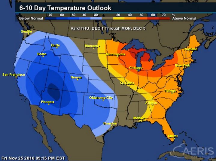
Here's the national temperature outlook from December 1st - 5th, which shows warmer than average temperatures across the eastern half of the country. Note that the Western US looks to be cooler than average, which would indicate another storm system brewing. Keep in mind that with the progressive weather pattern that we're in now, these warmer and cooler than average temperature predictions could be briefly lived as storm systems move across the country.
 __________________________________________
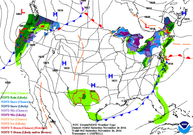
National Weather Outlook
The weather across the nation remains quite active with another fairly sizeable storm moving into the Western US. Heavy rainfall will be possible as this storm system slides across the nation. There will also be heavier snowfall potential in some locations.
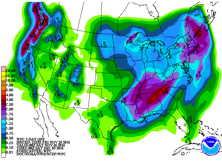
Precipitation Outlook
According to NOAA's WPC, our next storm system will be responsible for heavier moisture across the eastern half of the country with some spots seeing nearly 2" to 4"+ rainfall thru next weekend. This will help ease the drought in the Southeast. There will also be continued heavy moisture across the Western US.
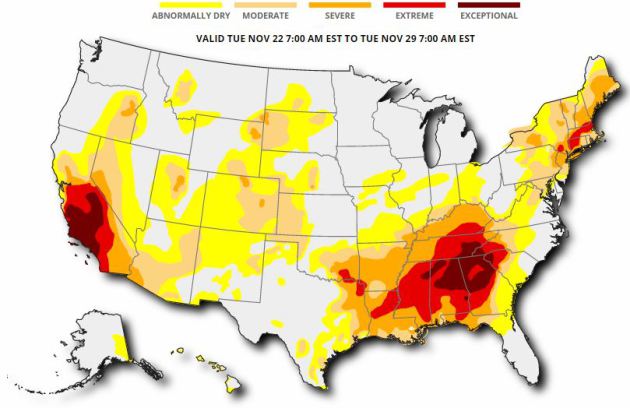
Drought Update
According to the US Drought Monitor, 55% of the nation of considered to be abnormally dry, while 17% of the country is in a severe drought, 8% is in an extreme drought and nearly 3% is in an exceptional drought. This is a little worse than it was a week ago. The good news is that we've recently gotten into a more active pattern, so hopefully we'll see some improvement in drought conditions across parts of the nation.
National Snowfall Outlook
Here's the potential snowfall through the end of the month and into early December, which shows that snowfall potential looks to be increasing across more of the US. This is certainly a change from what we had through the first half of November. Note that some of the heaviest snow looks to be found in the higher elevations out west.
_____________________________________________________________________________
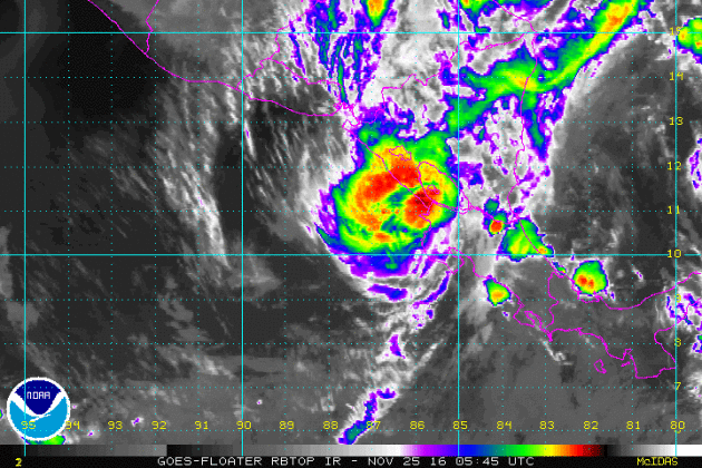
Otto in the Atlantic Basin
Here's a look at Otto in the Atlantic Basin from PM Friday as it moved east of Central America. Otto was a Category 2 Hurricane earlier this week making it the latest hurricane to develop in the western Caribbean on record, breaking the old record set by Martha in 1969. It was also the FIRST hurricane to ever make landfall in Costa Rica since records began!
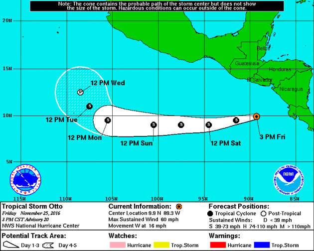
 Tracking Otto
Here's the official track for Otto, which suggests that it will continue to push west through the Eastern Pacific as a Tropical Storm through early next week.
Tracking Otto
Here's the official track for Otto, which suggests that it will continue to push west through the Eastern Pacific as a Tropical Storm through early next week.
 _____________________________________________________
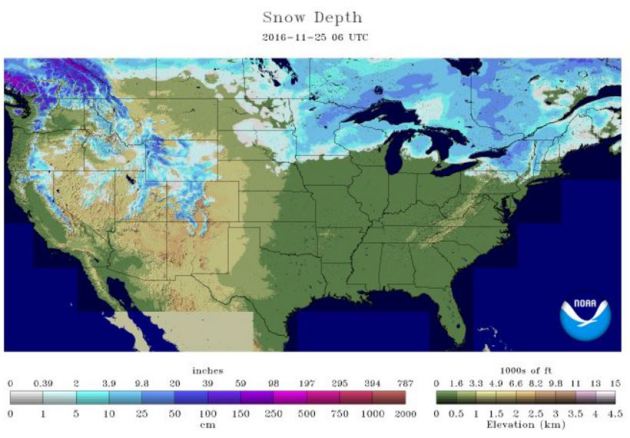
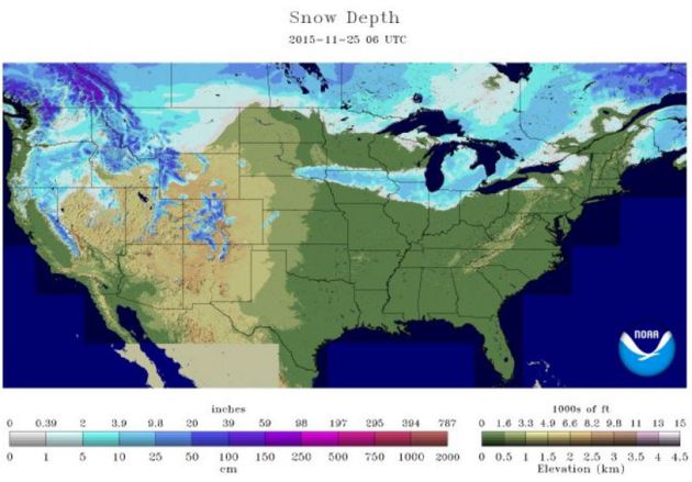
National Snow Cover
_____________________________________________________
National Snow Cover
According to NOAA's NOHRSC, 20.5% of the nation was covered up in snow as of November 25th. Last year at this time, there was 21.2%
_________________________________________________________________________
According to NOAA's NOHRSC, 20.5% of the nation was covered up in snow as of November 25th. Last year at this time, there was 21.2%
_________________________________________________________________________
"Scientists warn increasingly rapid melting could trigger polar ‘tipping points’ with catastrophic consequences felt as far away as the Indian Ocean"
"Arctic scientists have warned that the increasingly rapid melting of the ice cap risks triggering 19 “tipping points” in the region that could have catastrophic consequences around the globe.The Arctic Resilience Report found that the effects of Arctic warming could be felt as far away as the Indian Ocean, in a stark warning that changes in the region could cause uncontrollable climate change at a global level.Temperatures in the Arctic are currently about 20C above what would be expected for the time of year, which scientists describe as “off the charts”. Sea ice is at the lowest extent ever recorded for the time of year. “The warning signals are getting louder,” said Marcus Carson of the Stockholm Environment Institute and one of the lead authors of the report. “[These developments] also make the potential for triggering [tipping points] and feedback loops much larger.”"
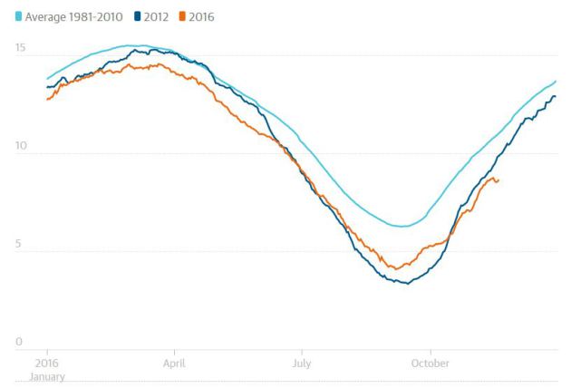
"Arctic sea ice extent shrank to its second lowest record this year, and is unusually low this winter"
(Guardian graphic | Source: National Snow & Ice Data Center)
____________________________________________________________________________
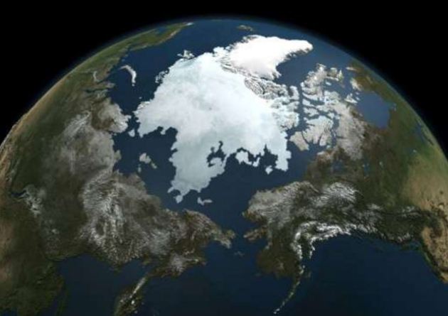
"Overheated Arctic sign of climate change 'vicious circle'"
Freakishly high temperatures in the Arctic driven by heat-packed oceans and northward winds have been reinforced by a "vicious circle" of climate change, scientists said Thursday. Air above the Polar ice cap has been 9-12 degrees Celsius (16.2 to 21.6 degrees Fahrenheit) above average during the last four weeks, according the data from the Danish Meteorological Institute (DMI), which tracks hourly changes in Arctic weather. And during several days last week, temperatures above the North Pole were a balmy zero degrees Celsius (32 degrees Fahrenheit), a full 20C (36F) above the levels typical for mid-November, said Martin Stendel, a DMI climate researcher based in Copenhagen. "This is by far the highest recorded" in the era of satellite data, starting in 1979, he told AFP. "What we are observing is very unusual." At this time of year, open Arctic ocean exposed by sea ice melted away in summer should be freezing again, with thousands of square kilometres icing over every day. But that has not been happening, at least not at the same pace, said Stendel. "Not only was the ice not growing as it would normally, there was further melting due to warm air coming in," he explained by phone. The US National Snow and Ice Data Center reported that sea ice extent in October was the lowest on record, some 6.4 million square kilometres (2.5 million square miles).
(Ice cover at the top of the globe shrank to its smallest area in 2016—some 4.14 million sq km (1.6 million sq miles)—on September 16)
 _____________________________________________________________________________
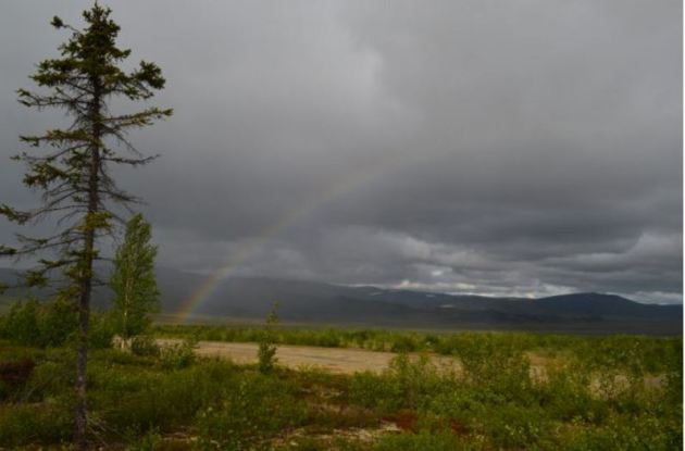
"Signs of climate change at Arctic tree line"
"Near the Arctic Circle, in northern Alaska, is where forests give way to tundra. Researchers are looking at how the warming climate might affect the ecology of this northern boundary. In northern Alaska’s Brooks Range, the earth as most of us know it comes to an end. From Fairbanks, the northernmost city on the North American road grid, drive up the graveled Dalton Highway. Unpeopled boreal forest stretches in all directions. About 200 miles on, you pass the arctic circle, beyond which the sun never sets in midsummer, nor rises in midwinter. Eventually, the trees thin out, and look scrawnier. The rolling landscape rises into big mountains, and you are threading through the bare, razor-edged peaks of the Brooks. Midway through the mountains, scattered spruces cling only to valley bottoms; further upslope is tundra, covered only with low-lying plants. At about 320 miles from Fairbanks, you pass the last little trees. Beyond lie the barren lands of the North Slope, ending at the industrial arctic-coast hamlet of Deadhorse and the oil fields of Prudhoe Bay—the only reason this road is here at all."
(Near the arctic circle in northern Alaska, forests begin giving way to tundra. as cold air, frozen soils and lack of sunlight squeeze out trees. Researchers are investigating how warming climate may affect the ecology of this boundary. Photo via Kevin Krajick)
___________________________________________________________________
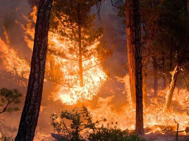
"Wildfires tear across drought-stricken parts of Peru"
"Wildfires have torn through more than 22,000 hectares (54,363 acres) of forest, protected areas and farmland in drought-stricken parts of Peru as the Andean country suffers one of its driest periods in years, authorities said on Thursday. The spate of wildfires in the past week were likely started by accident after peasant farmers burned fields to prepare them for planting, said Edgar Ortega with Peru's Civil Defense Institute. Strong winds fanned the flames that quickly crossed the Andean regions of Cajamarca and Lambayeque in northern Peru, which are experiencing prolonged droughts, Ortega said. Fires have been contained in five nature reserves, including the Laquipampa Wildlife Refuge that is home to the protected spectacled bear, the inspiration for the Paddington Bear character in English children's literature, said Cecilia Cabello with Peru's protected areas agency Sernanp. The charred remains of spectacled bears and other wildlife have been found in some areas, said Cabello."
(Image credit: NOAA)
__________________________________________________________________________
"'We are in shock': historic Bolivia drought hammers homes and crops"
"Teodora Cauna de Quispe hasn’t had water at her house in Bolivia’s capital, La Paz, for two weeks. “We can’t wash ourselves or our clothes,” she said. “Every so often there is a bit of muddy water that spurts out of the tap on my patio.” A tanker has delivered water only once, and Teodora – who, like many of her neighbors, works as a maid in a wealthy neighborhood nearby – has been forced to buy expensive bottled water for her family to drink. This week, President Evo Morales declared a national emergency, after the combined impact of the El Niño weather cycle, poor water management and climate change helped cause the country’s worst drought in 25 years. Water rationing is in effect for the first time ever in La Paz, where the three main reservoirs that provide the city’s water are almost dry. The semi-arid highlands surrounding the capital rely almost entirely on replenishment by rainfall. Five other cities face severe water shortages. Bread, a key staple here, is increasingly scarce and many hospitals are working at half capacity, suspending non-emergency surgeries and dialysis. In the poor neighborhoods of southern Sucre, taps have run dry for three weeks."
See more from the Guardian HERE:
See more from the Guardian HERE:
(Demonstrators holding buckets protest amid the drought, in the center of La Paz. Photograph: David Mercado/Reuters)

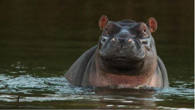
"Drought forces cull of Kruger hippos and buffaloes"
"Officials at South Africa’s biggest national park have defended the culling of hippos and buffaloes amid a devastating drought that has left millions of people in need of help. Critics claim that human intervention denies the ecosystem the shocks it needs to remain healthy in the long term, but staff at the Kruger National Park say that allowing the carcasses of animals to rot while villages in the region struggle to find enough food cannot be justified. Meat from culled animals can be distributed to locals. William Mabasa, a spokesman, said: “The drought is unprecedented, with an estimated 22 million persons in southern Africa in need of some assistance. South African National Parks cannot remain oblivious to this.”"
(Hippopotamuses are gathering at the few remaining natural water sources in Kruger National ParkCAMERON SPENCER/GETTY IMAGES)
"Elon Musk's SpaceX to Launch NASA's $112-Million Ocean-Surveying Satellite"
"Despite its recent anomaly, the explosion of a Falcon 9 rocket, Elon Musk's SpaceX still landed a deal with NASA to launch an innovative Ocean-Surveying satellite. This means SpaceX is still one of the top commercial space flight service companies out there. The project is under NASA's Earth science satellite program that is expected to launch within the next five years. SpaceX will launch the Surface Water and Ocean Topography spacecraft or SWOT. SWOT is designed to scan the Earth's ocean and will perform the first global survey of the planet's surface water. A SpaceX Falcon 9 rocket will deliver the satellite payload to space with the original launch date set for April 2021 from the launch pad in Vandenberg Air Force Base in California. The signed agreement intensifies SpaceX and NASA affiliation to launch another "critical" space mission. Aside from SWOT, SpaceX also launched several projects for the agency including Jason-3, another ocean monitoring satellite that was sent to space last January. In 2017, SpaceX is also set to launch the Transiting Exoplanet Survey Satellite (TESS). TESS is capable of detecting small planets or exoplanets near bright stars outside the Solar System. "We're excited to carry this critical science payload into orbit for NASA, the nation, and the international community," Gwynne Shotwell, SpaceX president said in a statement. "We appreciate NASA's partnership and confidence in SpaceX as a launch provider," Shotwell added. The project costs a total of $112 million. Some say its an increase from SpaceX Falcon 9 service labeled at only $62 million. This project also costs more than previous NASA-SpaceX collaboration like the Jason-3 satellite mission that was valued at $82 million and the TESS satellite at $87 million."
{Elon Musk's SpaceX landed on another NASA mission to launch the latest Ocean surveying satellite using a Falcon 9 rocket. (Photo : NASA via Getty Images)}

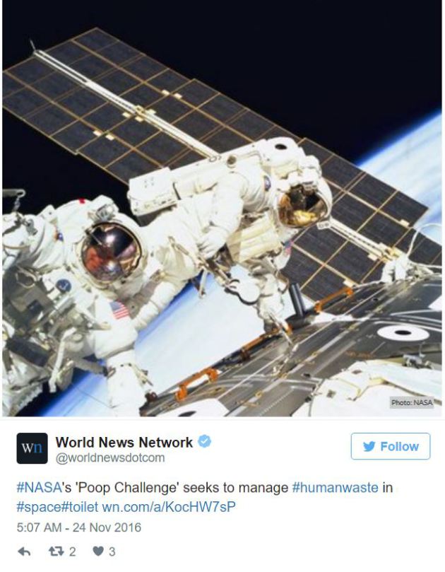
"NASA Asks Public to Help Solve Its Space S**t Problem"
All zipped up in a spacesuit and in full view of the entire crew, what's an astronaut to do, when they need to take a poo? NASA has launched a contest for investors to solve this uncomfortable issue, with a US$30,000 award promised to the one who can help the space agency solve this very human problem.
Technology has come a long way; rockets are sent into space, man has walked on the moon — several times — and so much has been achieved in the world engineering and science, that it seems strange we can not solve the pooing in space conundrum.
Technology has come a long way; rockets are sent into space, man has walked on the moon — several times — and so much has been achieved in the world engineering and science, that it seems strange we can not solve the pooing in space conundrum.

No comments:
Post a Comment