Minnesota Deer Opener Weather
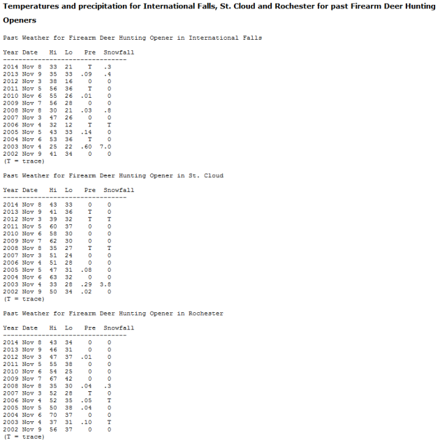
The Minnesota Climatology Office has put together some past Deer Opener Weather. For more information, click here. Check out the weather for the Deer Opener this year below!
______________________________
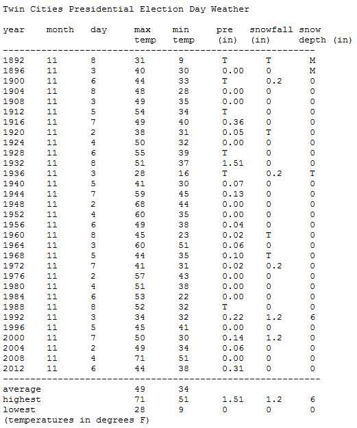
Twin Cities Election Day Weather
Tuesday is Election Day! The Minnesota Climatology Office
put together some past Presidential Election Day Weather for the Twin
Cities. The warmest was back in 2008 with a high of 71. Highs this year
will be in the upper 50s with mainly sunny skies. Here's a quick look at
past Presidential Election Day Weather for the Twin Cities:
______________________________
Recent Warm Temperatures Delaying Fall Fertilizer Application
______________________________
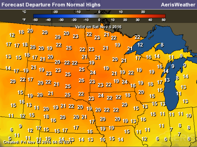
Near Record Warmth For The Deer Opener
By D.J. Kayser, filling in for Paul Douglas
70s in November? Can that happen? Or did we go through a change in latitude that I somehow missed?
Our warm stretch of weather continues again today as highs climb toward 70 with some passing clouds. We could even make a run toward the record of 71, set back in 2001. This will also be the warmest Minnesota Deer Opener in recent history. Most recently it was 67 back in 2004 and 64 in 2009 in the metro.
Hitting 70 in November is certainly rare, but it has happened before. Through 2015, the Twin Cities has hit 70 or higher 31 times, and we even did it twice last year (on November 2nd and 3rd). Temperatures today won't be approaching the warmest November temperature, however – that was 77, set in 1999 and 1933.
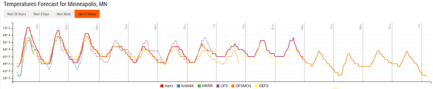
Warm weather, though not quite as warm as today, will stick around as we head into next week. Highs will remain above average for this time of year through at least next Friday before a potential cool down works in for the middle of the month.
Enjoy the warmth. The other shoe has to drop at some point... I think.
______________________________
Extended Forecast for Minneapolis
SATURDAY: A few passing clouds. High 69. Low 47. Chance of precipitation 0%. Wind S 3-5 mph.
SUNDAY: Some PM clouds. Warm weather continues. High 67. Low 48. Chance of precipitation 0%. Wind S 5-10 mph.
MONDAY: A touch cooler with afternoon showers. High 60. Low 44. Chance of precipitation 30%. Wind SW 5-10 mph.
TUESDAY: Gradually clearing skies. High 58. Low 42. Chance of precipitation 0%. Wind NW 3-7 mph.
WEDNESDAY: Above average weather continues. High 60. Low 45. Chance of precipitation 0%. Wind SE 3-7 mph.
THURSDAY: Perfect November day. High 58. Low 46. Chance of precipitation 0%. WInd SW 5-10 mph.
FRIDAY: Mix of clouds and sun. High 57. Low 41. Chance of precipitation 0%. Wind NE 5-10 mph.
______________________________
Climate Stat Pack From November 4th (through 7 PM)
High Friday: 68
Low Friday Morning: 41
Precipitation: 0.00"
Rainfall since January 1st: 35.20" (+7.29" above average)
______________________________
This Day in Weather History
November 5th
1941: A snowstorm hits southern Minnesota, with the heaviest snow at Fairmont.November 5th
______________________________
Average Temperatures & Precipitation for Minneapolis
November 5th
November 5th
Average High: 48F (Record: 71F set in 2001)
Average Low: 32F (Record: 3F set in 1951)
Average Precipitation: 0.07" (Record: 0.93" set in 1948)
Average Snow: 0.2" (Record: 4.2" in 1959)
______________________________
Average Low: 32F (Record: 3F set in 1951)
Average Precipitation: 0.07" (Record: 0.93" set in 1948)
Average Snow: 0.2" (Record: 4.2" in 1959)
______________________________
Sunrise/Sunset Times for Minneapolis
November 5th
Sunrise: 7:58 AMNovember 5th
Sunset: 5:55 PM
*Length Of Day: 9 hours, 57 minutes and 19 seconds
*Daylight Lost Since Yesterday: ~2 minutes and 40 second
*Next Sunrise That Is BEFORE 7 AM: November 6th (6:59 am) (Due to time shift "fall back" that occurs that morning)
*Next Sunset That Is At/Before 5 PM: November 6th (4:54 pm) (Due to time shift "fall back" that occurs that morning)
______________________________
Minnesota Weather Outlook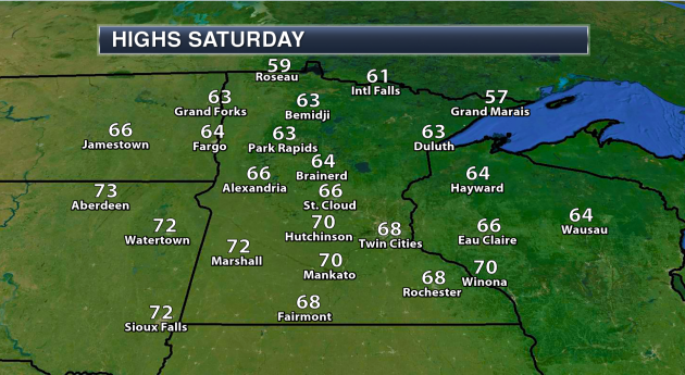
______________________________
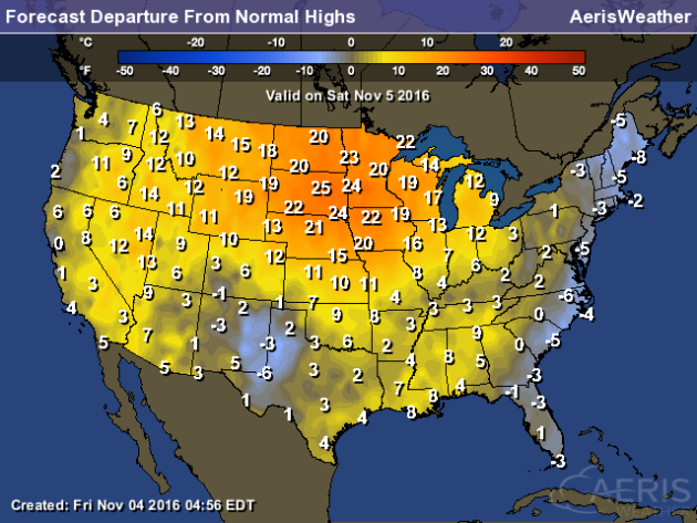
National Weather Stories
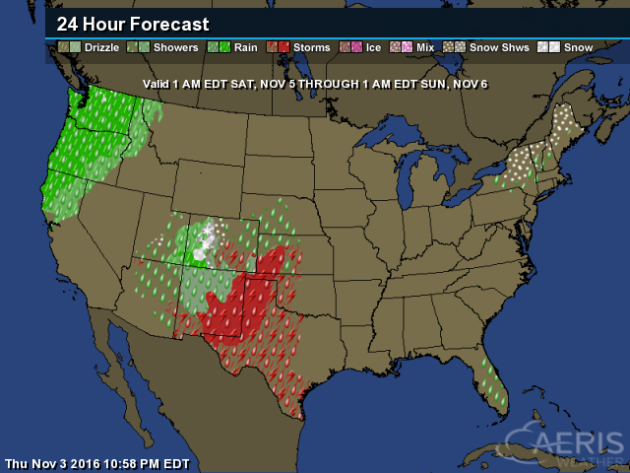
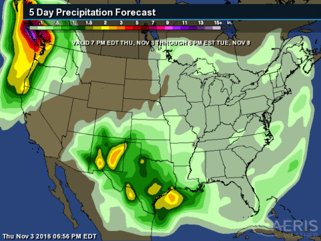
Some
locations in the Northwest already saw their wettest October on record
last month, and Saturday will bring much of the same to the region with
more rainfall. Meanwhile, storms are possible across parts of the
central and southern Plains/Rockies, with some snow possible in parts of
the Colorado Rockies where 3-6" will be possible for areas like
Telluride. Some rain and snow will be possible across New England, with a
dusting up to two inches of snow likely for parts of northern New
Hampshire and Vermont as well as western Maine.
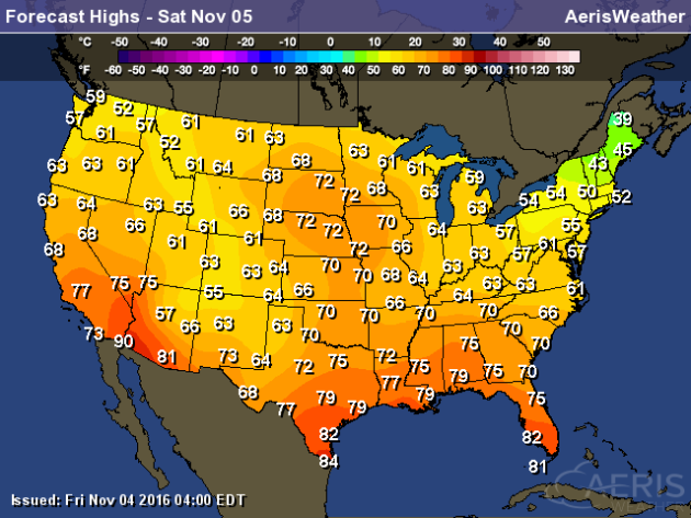
The
coolest weather Saturday will be in New England, with highs only making
it into the 30s and 40s in spots. Across the rest of the country,
warmth continues, with 70s as far north as parts of South Dakota and
Minnesota.
Election Day Forecast

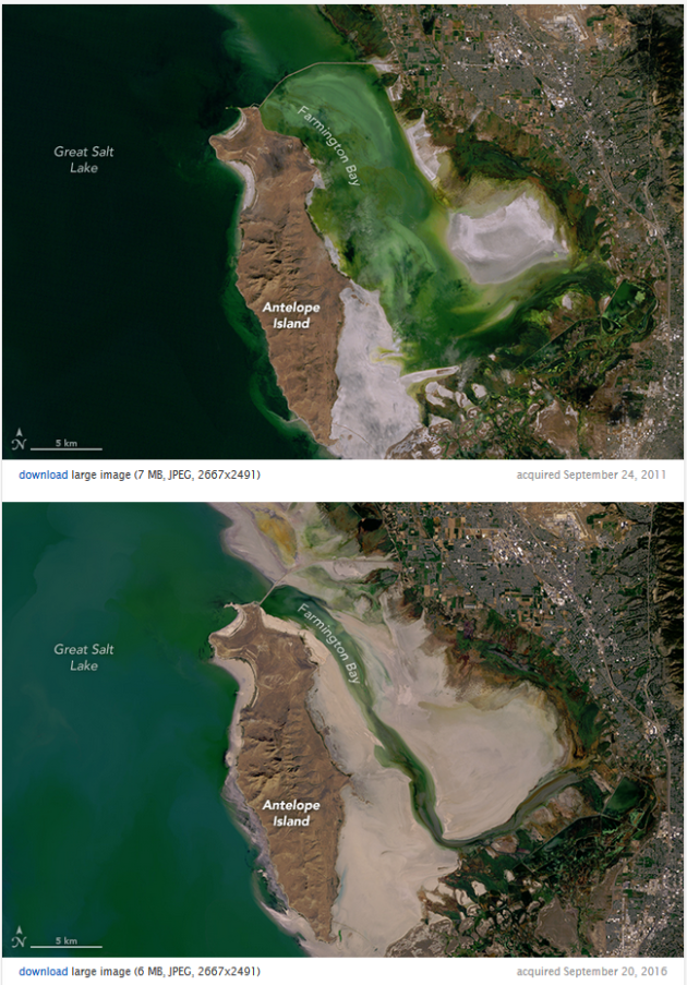
The Great Salt Lake Is Drying Up
______________________________
Thanks for checking in and have a great Saturday! Don't forget to follow me on Twitter (@dkayserwx) and like me on Facebook (Meteorologist D.J. Kayser)!
- D.J. Kayser

No comments:
Post a Comment