35 F. average high on November 21.
27 F. high on November 21, 2015.
November 22, 1996: Heavy snowfall accumulates over the same areas that were hit two days earlier. Four to seven inches of snowfall are reported across the area. Heavier snowfall occurred during the daylight hours of the 23rd. Snowfall totals of six inches were reported in the Twin Cities, Chanhassen, Stewart, St. James and Redwood Falls.
November 22, 1970: Gale-driven snow falls across Minnesota. 45 mph winds are reported over Rochester and Duluth.
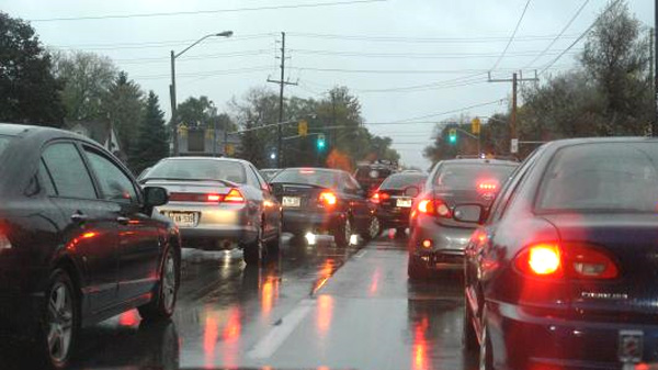
Weather Goes From Minnesota Nice to Minnesota Ice
Over the years I've learned a few things the hard way. The timing of a storm is obviously critical. So is the surface temperature. We tend to get hung up on snow amounts ("Hey Paul, where's that 4 inches you promised me!") when air temperature often determines how bad rush hour will be.
Colder storms tend to be more dangerous. Snow falling at 15F compresses into ice, and chemicals take time to melt this dangerous, slippery crust. In fact an inch at 17F can be far more hazardous to drive on than 6 inches of slush at 33F.
A layer of mild air aloft may result in a mixed bag of snow, sleet (ice pellets), even freezing rain - the most dangerous form of wintry precipitation. MnDOT-treated freeways may stay wet and slushy during the daylight hours today, but I expect roads to become icier everywhere tonight with a changeover back to snow. 2-4 inches falls by Wednesday in the metro with more over central Minnesota.
Light snow brushes southern Minnesota Thursday night; ECMWF guidance hints at a few more inches of slush Sunday night as rain changes back to snow.
Dig out the parkas - December looks good and cold.
Winter Weather Advisory.
No watches or warnings, but the local Twin Cities office of the
National Weather Service has issued a Winter Weather Advisory for much
of the state, including the immediate MSP metro. Details:
WINTER WEATHER ADVISORY REMAINS IN EFFECT FROM 2 PM TUESDAY TO 6 AM CST WEDNESDAY...

* EXPECT WET SNOW TO DEVELOP AROUND 2 PM TUESDAY AND THEN DIMINISH AROUND 6 AM WEDNESDAY.

* THE HEAVIEST SNOWFALL RATES WILL OCCUR BETWEEN 6 PM TUESDAY AND MIDNIGHT WEDNESDAY.

* TOTAL WET SNOW ACCUMULATIONS OF 2 TO 5 INCHES ARE EXPECTED.

* LOOK FOR REDUCED VISIBILITIES AT TIMES.

* PLAN ON SLIPPERY ROAD CONDITIONS.
Wednesday Travel Weather. Models print out showers from the Great Lakes and Ohio Valley to the Gulf Coast. No major problems getting hom on Wednesday. Map: Aeris AMP.
Thursday Travel Weather. Heavy rain pushes into the Pacific Northwest, otherwise relatively dry, quiet weather prevails on Thanksgiving Day with pleasant temperatures over the southern half of the USA.
Instant Winter. Reports of serious, lake effect snows for upstate New York and much of New England:
A Raw Thanksgiving Parade. Conditions are ripe for rain showers in New York City Thursday - not a steady, heavy rain, but it will definitely look and feel like late November.
Animation credit: "Changes in the concentration of Arctic sea ice between Nov. 12 and 19, 2016 are seen in this animation of satellite data. The North Pole is at the center. Areas with 100 percent coverage of ice are depicted in white. Lighter to darker blue tones are indicative of decreasing concentrations. And areas with no ice are in gray. Ice actually decreased within the area circled in red in the first frame of the animation." (Data: University of Bremen. Images: Polar View. Animation: Tom Yulsman).
Graphic credit: "The normalized value of global sea ice area as of November 17, 2016, was so far from any other total in the 37-year record that it represented a departure of about 8 standard deviations below the average! Image credit: Wipneus, using data from National Snow and Ice Data Center." (NSIDC was not involved in producing this image.)
U.S. Launches Revolutionary Weather Satellite. The Washington Post has more clarity and background on what makes GOES-R a massive step forward for the science of meteorology: "...The “camera” instrument on GOES-R — called the Advanced — doubles the resolution of the current NOAA satellites. It can scan the whole hemisphere in five minutes, and if there’s a particularly dangerous weather pattern approaching, forecasters can scan a smaller region over the United States every 30 seconds. Sudden bursts of lightning could mean thunderstorms are becoming severe. So, GOES-R has a lightning mapper to continuously monitor and transmit all of the lightning strikes across North America and the surrounding oceans..."
Image credit: "Schematic of GOES-R with instruments labeled." (NOAA/NASA).
What's It Like To Fly Into The Eye of a Hurricane? Here's an excerpt of a fascinating chronology of a Hurricane Hunter flight into "Matthew", courtesy of NOAA AOML: "...We
started bouncing up and down at a much faster rate, much like a very
intense wooden roller coaster, as I tried to contain my stomach from
getting too upset. As we pounded through the eyewall and made it into
the eye, what I saw and experienced was truly breathtaking; thick white
clouds above and below as far as the eye could see as blue skies and
ocean attempted to pierce through, the turbulence experienced just
moments prior was quickly winding down, and a sense of calmness
surrounded us as we entered the eye of Hurricane Matthew. I was so taken
aback by the magnitude of what I was seeing that I almost forgot to do
my job and immediately started taking pictures and videos of the eye..."
Photo credit: "The eyewall of Hurricane Matthew as the aircraft was making a pass through." Image credit: NOAA.
Photo credit: "A stand of pine-beetle killed lodgepole pines on the White River National Forest." @bberwyn photo.
Earthquakes: Reckoning With The Big One in California - And It Just Got Bigger. Here's a good summary of a recent study at The Wall Street Journal: "...For years, scientists believed the mighty San Andreas—the 800-mile-long fault running the length of California where the Pacific and North American plates meet—could only rupture in isolated sections. But a recent study by federal, state and academic researchers showed that much of the fault could unzip all at once, unleashing a rare, singular catastrophe. Now, insurers have used that research to come up with a new analysis of the damage that could be caused by statewide break of the San Andreas..."
Photo credit above: "A 6.7-magnitude earthquake struck the Northridge suburb of Los Angeles in 1994, causing 57 deaths and $20 billion in property damage. Researchers say a statewide quake above 8.0 could cause $289 billion in damage just to homes alone." Photo: AP.


Major
Hurricane Joaquin is shown at the far eastern periphery of the GOES
West (GOES-15) satellite’s full disk extent, taken at 1200Z on October
1, 2015. Credit: NOAA
Read more at: http://phys.org/news/2016-11-noaa-goes-r-satellite.html#jCp
Read more at: http://phys.org/news/2016-11-noaa-goes-r-satellite.html#jCp
Major
Hurricane Joaquin is shown at the far eastern periphery of the GOES
West (GOES-15) satellite’s full disk extent, taken at 1200Z on October
1, 2015. Credit: NOAA
Read more at: http://phys.org/news/2016-11-noaa-goes-r-satellite.html#
Read more at: http://phys.org/news/2016-11-noaa-goes-r-satellite.html#
Quit Social Media, Your Career May Depend On It. Are we distracting ourselves to death? Here's an excerpt from an interesting essay at The New York Times: "...The
idea that if you engage in enough of this low-value activity, it will
somehow add up to something of high value in your career is the same
dubious alchemy that forms the core of most snake oil and flimflam in
business. Professional success is hard, but it’s not complicated. The
foundation to achievement and fulfillment, almost without exception,
requires that you hone a useful craft and then apply it to things that
people care about. This is a philosophy perhaps best summarized by the
advice Steve Martin used to give aspiring entertainers: “Be so good they
can’t ignore you.” If you do that, the rest will work itself out,
regardless of the size of your Instagram following..."

How Social Media Broke Democracy.
We are lost in our social media news consumption bubbles, and this
makes it harder to empathize with others? Here's an excerpt of a
thought-provoking essay from Tobias Rose-Stockwell at Medium: "...Facebook has stated that their mission is to make the world a more open and connected place. And they have, by anyone’s measure, connected more humans than any company in history.
With this success, they have also created a tool that has allowed us to
become more insulated in our own ideological bubbles than we ever have
been before. Because of this lack of pluralism, we are systematically losing our ability to empathize.
This is what we now see in the wider world — from Brexit to Trump to
hyper-nationalistic movements worldwide. People globally no longer have
the same incentives to find a shared understanding. This is not just
dissatisfaction with globalization or the status quo. This is how we are changing our society by not seeing each other..."
Image credit: Wall Street Journal's Blue Feed, Red Feed. Check out the different in tone, style and "facts" for the same topic.
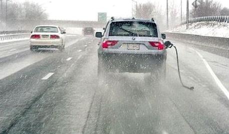
Photo credit: "Minnesota's winter snuck up on us. Then whacked us in the face." Ethan Gibbs.

TODAY: Weather Advisory. Mix of snow and ice. Roads become increasingly slushy by late afternoon Winds: SE 10-15. High: 33
TUESDAY NIGHT: Mix changes back to all snow. Low: 30
WEDNESDAY: Snow tapers to flurries. 2-5" totals in the STC metro. Winds: NW 7-12. High: 35
THANKSGIVING DAY: Mostly cloudy, nighttime flurries? Winds: W 5-10. Wake-up: 29. high: near 40
BLACK FRIDAY: Good shopping weather. Peeks of sun. Winds: SW 5-10. Wake-up: 28. High: 41
SATURDAY: Fading sun, nicer day of the weekend. Winds: S 8-13. Wake-up: 30. High: 44
SUNDAY: Rain changes to wet snow late. Winds: NE 10-20. Wake-up: 33. High: 45 (falling late)
MONDAY: Flurries taper, some clearing late. Winds: NW 10-20. Wake-up: 32. High: 36
Climate Stories
Paul Douglas Lays Out a Faith-Based Approach to Climate Change. My thanks to Esme Murphy and WCCO-TV for inviting me to come to the station Sunday and discuss ways to reach out to evangelicals and conservatives; to try and tell the climate story in ways that resonate with their lives and spirituality. Here's an excerpt from CBS Minnesota: "Douglas, who was a guest on WCCO Sunday Morning, said his book in an attempt to reframe the discussion about climate change into something beyond just the science, which he describes as undeniable. “You can pile on the science, but at some point, people tune out the science,” Douglas said. “But if you frame this under the guise of clean energy, energy freedom, energy security…it’s framing the story in a way that resonates and appeals to peoples’ faith.” Douglas says that Christians, as stewards of the Earth, have a moral obligation to do something about climate change and the threat it poses to the world..."
* The complete 5 minute interview on WCCO-TV is here.
Graphic credit: "This figure shows the percentage of daily temperature records set at weather stations across the contiguous 48 states by decade. Record highs (red) are compared with record lows (blue)." (U.S. EPA from Meehl et al., 2009)

Photo credit: Pascal Sittler/REA/Redux. "Rex Tillerson, CEO of ExxonMobil, at the World Gas Conference, Paris, June 2015."
No comments:
Post a Comment