"AAA: 48.7 Million Americans to Travel this Thanksgiving"
"1 million more travelers than last year will take to the highways, skies and seas"
"AAA projects that 48.7 million Americans will journey 50 miles or more from home this Thanksgiving, an increase of one million travelers compared with last year. This represents a 1.9 percent increase over 2015, and the most Thanksgiving travelers since 2007. The Thanksgiving holiday travel period is defined as Wednesday, Nov. 23, to Sunday, Nov. 27."
See more from Newsroom.AAA.com HERE:
 Thanksgiving Holiday Travel
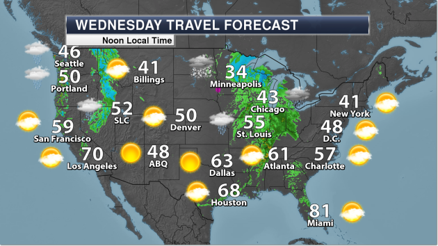
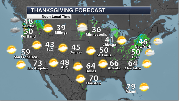
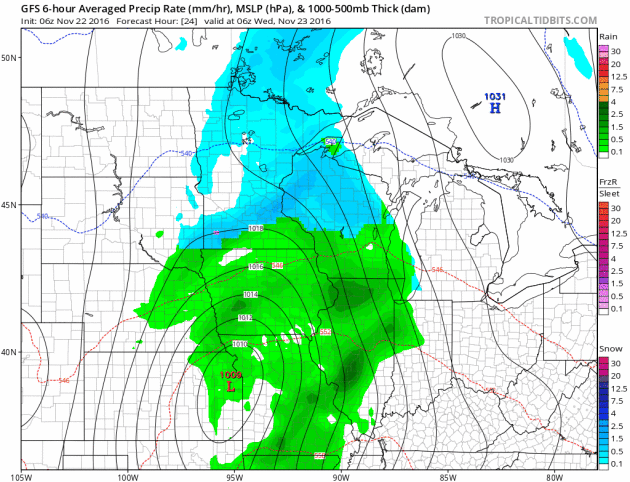
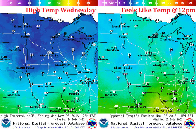
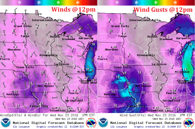
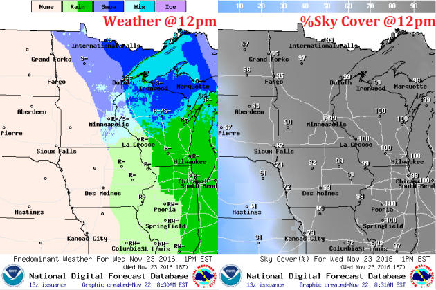
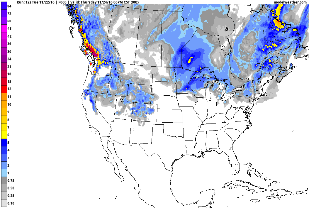
A storm system moving through the eastern half of the country on Wednesday and Thursday will make for soggy traveling conditions for many Americans as they travel along highways and airport hubs. The images below suggest weather conditions and temperatures around midday on Wednesday and Thanksgiving Day Thursday.
 _______________________________________________
Visible Satellite PM Monday
_______________________________________________
Visible Satellite PM Monday
Here's an interesting visible satellite loop from PM Monday, which showed the fresh snow from the storm system late last week across Minnesota. You can see the snow (stationary) vs clouds (moving) pretty clearly in the loop below. Note that the clouds moving in PM Monday were from the same storm system that brought us wintry precipitation and accumulating snow on Tuesday!
.gif)
 ______________________________________________________
Active Weather Continues...
______________________________________________________
Active Weather Continues...
"1 million more travelers than last year will take to the highways, skies and seas"
"AAA projects that 48.7 million Americans will journey 50 miles or more from home this Thanksgiving, an increase of one million travelers compared with last year. This represents a 1.9 percent increase over 2015, and the most Thanksgiving travelers since 2007. The Thanksgiving holiday travel period is defined as Wednesday, Nov. 23, to Sunday, Nov. 27."
See more from Newsroom.AAA.com HERE:
A storm system moving through the eastern half of the country on Wednesday and Thursday will make for soggy traveling conditions for many Americans as they travel along highways and airport hubs. The images below suggest weather conditions and temperatures around midday on Wednesday and Thanksgiving Day Thursday.
Here's an interesting visible satellite loop from PM Monday, which showed the fresh snow from the storm system late last week across Minnesota. You can see the snow (stationary) vs clouds (moving) pretty clearly in the loop below. Note that the clouds moving in PM Monday were from the same storm system that brought us wintry precipitation and accumulating snow on Tuesday!
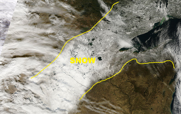
Here's a higher resolution visible satellite image of the snow across parts of the Upper Midwest from the winter storm late last week. Also note that you can see several large lakes below as they are not yet frozen and show up black in the image below.
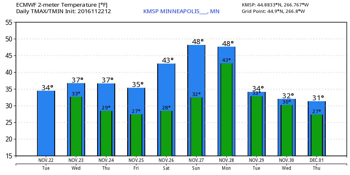
Here's the weather outlook from Wednesday to Wednesday of next week. Note our first storm system from Tuesday to AM Wednesday that brought us wintry precipitation and accumulating snow with another brief shot of light snow on Thursday before another (potentially) larger storm moves in during the early part of next week.
______________________________________________________________________________
"Silently, like thoughts that come and go, the snowflakes fall, each one a gem" wrote William Hamilton Gibson. Snow would be even nicer if we could somehow keep it off the roads.
An estimated 70 percent of America's roads are located in snowy areas. And 70 percent of accidental deaths that occur in the wintertime take place in automobiles.
According to SafeWinterRoads.org over 1,300 people are killed, another 117,000 injured in vehicle crashes on snowy, slushy or icy pavement, annually. 24 percent of weather-related vehicle crashes occur on snowy, slushy or icy pavement. Front-wheel and AWD helps to lower the risk but people still drive too fast for the conditions.
Be careful out there; a few inches of slush falls before snow tapers to flurries. A burst of flurries arrives late in late on Thanksgiving but I don't see any travel hassles Friday into much of Sunday.
For the next storm temperatures aloft may be mild enough for rain from Sunday night into Monday, ending as slush Tuesday.
I still see a cold start to December, and odds favor more snow and cold than last winter.
___________________________________________________
Extended Weather Outlook
TUESDAY NIGHT: Mix changes back to all snow. 1" to 3" possible. Winds: ESE 5-10. Low: 32
WEDNESDAY: Light rain/snow mix ends early afternoon. Winds: NW 5-10. High: 36
WEDNESDAY NIGHT: Mostly cloudy and quiet. Winds: WNW 5. Low: 30.
THANKSGIVING DAY: Mostly cloudy, nighttime flurries. Winds: W 5-10. High: 39
BLACK FRIDAY: Peeks of sun, dry at the mall. Winds: W 5-10. Wake-up: 29. High: 38
SATURDAY:Partly sunny and milder. Winds: S 8-13. Wake-up: 28. High: 44.
SUNDAY: Clouds increase, rain at night. Winds: S 8-13. Wake-up:33. High: 48.
MONDAY: Cold rain, possibly heavy at times. Winds: SE 10-20. Wake-up: 43. High: 47
TUESDAY: Light snow tapers. A little slush?. Winds: NW 10-20. Wake-up: 32. High: 36.
_______________________________
_______________________________
This Day in Weather History
November 23rd
2003: New London and Little Falls both receive 9 inches of new snow.November 23rd
1983: Heavy snowfall accumulates over most of central Minnesota with snowfall totals from 4 inches to almost 1 foot. Minneapolis received 11.4 inches of snow, while Farmington had 11 inches.
1954: Very strong winds over Minnesota lead to considerable damage in downtown Wadena.
________________________________
Average High/Low for Minneapolis
November 23rd
Average High: 37F (Record: 55F set in 1905)
Average Low: 22F (Record: -6F set in 1898)
Average Low: 22F (Record: -6F set in 1898)
Record Snowfall: 11.4" set in 1983
_________________________________
_________________________________
Sunrise/Sunset Times for Minneapolis
November 23rd
November 23rd
Sunrise: 7:21am
Sunset: 4:37pm
Sunset: 4:37pm
*Daylight Lost Since Yesterday: ~1mins & 58sec
*Daylight Lost Since Summer Solstice: ~6hours and 20mins
______________________________________________________________________
*Daylight Lost Since Summer Solstice: ~6hours and 20mins
______________________________________________________________________
Moon Phase for November 3rd at Midnight
2.9 Days After Last Quarter
2.9 Days After Last Quarter
Weather Outlook Wednesday
After a VERY warm start to the month, we've now seemed to settle into a more normal routine for mid/late November. Temperatures have been running a little closer to average and we've also been dealing with waves of wintry precip. High temps on Wednesday will once again be pretty closer to normal for this time of the year.
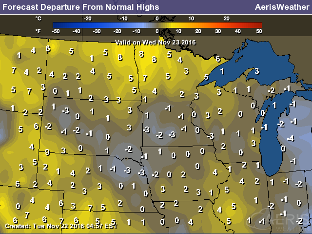
High Temperatures From Average Wednesday
Here's a look at high temperatures from average on Wednesday, which suggests near normal temps across much of the state. However, note that some areas in the northern part of the state will be warming to near 5F - 10F above average levels.
Weather Outlook Wednesday
As our storm system slides through the region, winds on Wednesday won't be too big of an issue. They certainly won't be as strong as they were last last week as our first major winter storm of the season plowed through the region on Friday.
Weather Outlook Wednesday
Much of the wintry precip will wrap up on Wednesday. Note that the heaviest precipitation by midday Wednesday will be pushing into the Arrowhead of MN and northern Wisconsin. Clouds look to persist across the Upper Midwest throughout much of the day Wednesday.
___________________________________________________________
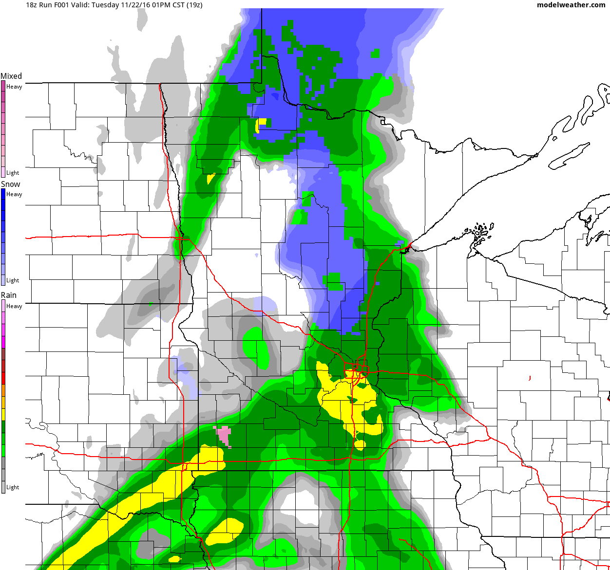
Simulated Radar
The simulated radar from Tuesday to Friday shows the heaviest precipitation from our weak storm system wrapping up by AM Wednesday with lingering light precipitation staying with us through Thanksgiving Day Thursday.
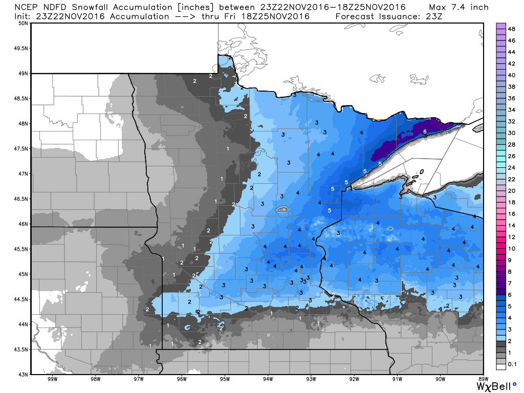
Snowfall Potential
Here's a look a the snowfall potential through midday Friday, which shows accumulating snow up to 2" to 4" possible across parts of central and northeastern MN into northern WI, much of which will come in PM Tuesday - AM Wednesday.
 _______________________________________
Extended Weather Outlook
The temperature outlook for Minneapolis through the end of the month suggests near average temperatures through Friday. Note that there appears to be a brief warming trend into the 40s this weekend before we drop back to average or slightly below average temps by next week.
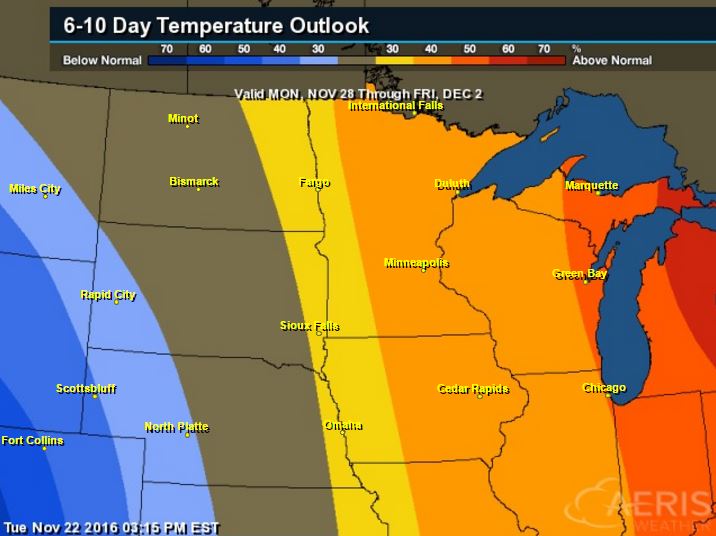
Warm Temperatures Return to Midwest
According to NOAA's CPC, the 6 to 10 day temperature outlook suggests warmer than average temperatures across much of the Upper Midwest and Great Lakes as we approach the end of the month.
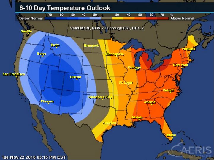
Here's the national temperature outlook from November 28th - December 2nd, which shows warmer than average temperatures across the eastern half of the country. Note that the Western US looks to be cooler than average, which would indicate another storm system brewing. Keep in mind that with the progressive weather pattern that we're in now, these warmer and cooler than average temperature predictions could be briefly lived as storm systems move across the country.
__________________________________________
National Weather Outlook
Our more active weather patter is certainly more evident now as several storm systems work across the nation through the end of the week. The first of which will bring a wintry mix and accumulating snow across parts of the Upper Midwest, the Great Lakes and the Northeast. The next system will bring heavier rain along the West Coast and snow to the high elevations in the Northwest.
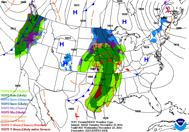
Precipitation Outlook
According to NOAA's WPC, heavy moisture will continue along the West Coast, mainly from northern California to Oregon and Washington. Scattered showers and storms could lead to heavier pockets of rain in the Deep South.
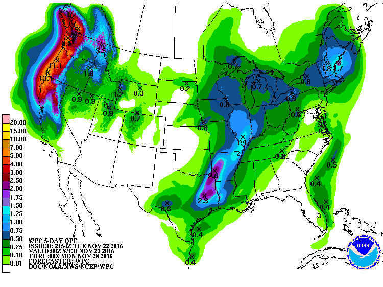
National Snowfall Outlook
Here's the potential snowfall through Saturday which shows heavier snow starting to move in along the high elevations in the Western US.
 _____________________________________________________________________________
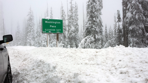
"North Cascades Highway waiting game is over"
"Twice a year we play a waiting game involving - arguably - the most beautiful stretch of highway in Washington. That waiting game is over for 2016. The State Route 20 North Cascades Highway is closed for the winter. After temporarily closing the highway on Friday, Nov. 18 due to increased avalanche risk, we reevaluated the conditions on Monday morning and, combined with a forecast of increasingly rough weather later this week, decided to call it a season. The pass opened on April 22 after about a month of work by our crews clearing the roadway. This year's closing is almost a week later than in 2015, when we closed it on Nov. 16."
(The SR 20 North Cascades Highway closed for the winter on Monday, Nov. 21.)
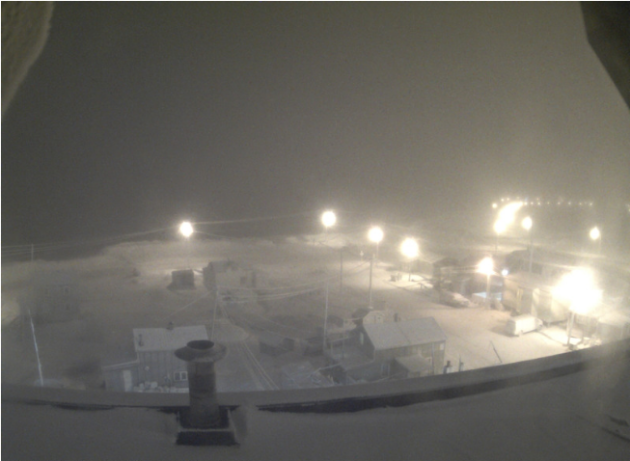
___________________________________________________________________________"In Barrow, Alaska, the Sun Just Set for the Final Time"
"The northernmost city in the U.S. is changing its name."
"On Friday, November 18th, the sun set for the final time in Barrow, Alaska, as the city plunges into polar darkness for the next two months and, in December, formally changes its name to Utqiaġvik, according to Alaska Dispatch News. The next dawn in Utqiaġvik will be January 22, 2017, the first sunlight under its new name, an Inupiaq word that the wider area of Barrow has long gone by. The city of around 4,300 was incorporated in 1958 and originally took its name from nearby Point Barrow, named by a Royal Navy officer in 1825. The city is the northernmost in the U.S. and each year spends a couple of months in darkness, owing to its position hundreds of miles north of the Arctic Circle, and about 2,000 miles northwest of Seattle. Residents recently voted to permanently change the town’s name to honor indigenous peoples and the area’s roots."
See more from AtlasObscura.com HERE:
(Barrow, Alaska in darkness on Monday. UNIVERSITY OF ALASKA-FAIRBANKS)
___________________________________________________________________________
"Trump to Cut NASA's Climate Change Budget, Shift Focus to the Moon"
"Now that President-elect Donald Trump is meeting with his transition committee, NASA is more than ever, prepared to welcome the new leader. However, speculations are circulating saying that Trump threatens to decrease the agency's climate change budget to shift focus on the moon and the solar system.Reports say that Donald Trump will cut NASA's budget to fund missions that will send humans on the edge of the Solar System and to the moon. Although it may sound appealing, that the new leader is actually interested in deep space explorations, it is despondent to hear that the president-elect might still think climate change is a hoax due to this move."
President-elect Donald Trump will reported slash NASA's climate change budget to fuel deep space missions to the edge of the Solar System and to send humans to the moon.
(Photo : Drew Angerer/Getty Images)
(Photo : Drew Angerer/Getty Images)

___________________________________________________________________________
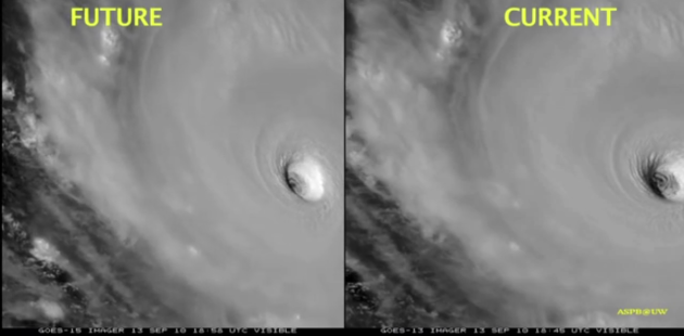
"How Nasa's super satellite will 'revolutionise' weather forecasts: Animation reveals the stunning details it sees on Earth"
"The new GOES-R satellite will track US weather as never before and launched on Saturday eveningA GIF shows a comparison between the current technology and what the latest imaging will look likeSatellite will provide better warning of floods and turbulence and will help tracking volcanic ash cloudsNasa launched the mission this month, which will see a further three next generation weather satellites launched, keeping the GOES network operational until 2036"
___________________________________________________________________________
"BRAZIL’S FAST BEAN PLANTING MEANS MORE 2017 CORN"
"Brazil farmers are experiencing their fastest soybean planting season in history because of favorable weather. But this also means that the country’s second corn crop, planted in the winter right after soybeans are harvested in the center-western part of the country, may well be huge and create pressure for the corn market until the middle of 2017. In recent weeks, INTL FCStone warned observers that soybean planting already reached 30% of expected area, while the usual time to reach this percentage was by the second week of November — a clear indication to make room to plant more corn in the second corn crop in the ideal window for the winter. As of Monday, according to the latest national estimate made by AgRural, soybean planting has reached 73% of the area with a delay in southern states, where corn is just harvested in the summer."
See more from Agriculture.com HERE:
___________________________________________________________________________"NASA plans to set fires in space"
"The National Aeronautics and Space Administration is collecting data on fire safety by setting fires in space. In their second round of experiments, NASA is igniting nine different samples aboard their spacecraft, the Cygnus cargo vehicle, as it orbits Earth. The samples include a cotton-fiberglass blend called Nomex, which is the same acrylic glass used for spacecraft windows. The experiment, called Saffire-II, launched in October 2016 and NASA says the mission will help “develop deep space habitation capabilities,” as well as “validate important habitation-related systems and operations in low-Earth orbit.” Saffire-II is the second of a three-part experiment and aims to build on the data collected during the previous fire safety experiment, Saffire-I. NASA partnered with the European Space agency and began igniting test samples on Monday around 7:15 pm Eastern Time. Saffire-I investigated “large-scale flame spread and material flammability limits in long duration microgravity,” according to NASA’s website. Before this experiment, the largest fire experiment ever conducted in space was about the size of an index card."
See more from TheBlaze.com HERE:
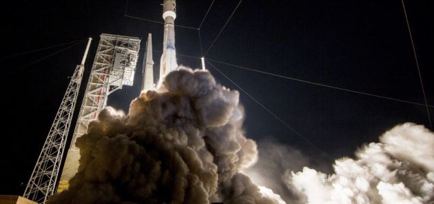
"This photo provided by United Launch Alliance shows a United Launch Alliance (ULA) Atlas V rocket carrying GOES-R spacecraft for NASA and NOAA lifting off from Space Launch Complex-41 at 6:42 p.m. EST at Cape Canaveral Air Force Station, Fla., Saturday, Nov. 19, 2016. The most advanced weather satellite ever built rocketed into space Saturday night, part of an $11 billion effort to revolutionize forecasting and save lives. (United Launch Alliance via AP)"
 ____________________________________________________________________________
"Brazil farmers are experiencing their fastest soybean planting season in history because of favorable weather. But this also means that the country’s second corn crop, planted in the winter right after soybeans are harvested in the center-western part of the country, may well be huge and create pressure for the corn market until the middle of 2017. In recent weeks, INTL FCStone warned observers that soybean planting already reached 30% of expected area, while the usual time to reach this percentage was by the second week of November — a clear indication to make room to plant more corn in the second corn crop in the ideal window for the winter. As of Monday, according to the latest national estimate made by AgRural, soybean planting has reached 73% of the area with a delay in southern states, where corn is just harvested in the summer."
See more from Agriculture.com HERE:
___________________________________________________________________________"NASA plans to set fires in space"
"The National Aeronautics and Space Administration is collecting data on fire safety by setting fires in space. In their second round of experiments, NASA is igniting nine different samples aboard their spacecraft, the Cygnus cargo vehicle, as it orbits Earth. The samples include a cotton-fiberglass blend called Nomex, which is the same acrylic glass used for spacecraft windows. The experiment, called Saffire-II, launched in October 2016 and NASA says the mission will help “develop deep space habitation capabilities,” as well as “validate important habitation-related systems and operations in low-Earth orbit.” Saffire-II is the second of a three-part experiment and aims to build on the data collected during the previous fire safety experiment, Saffire-I. NASA partnered with the European Space agency and began igniting test samples on Monday around 7:15 pm Eastern Time. Saffire-I investigated “large-scale flame spread and material flammability limits in long duration microgravity,” according to NASA’s website. Before this experiment, the largest fire experiment ever conducted in space was about the size of an index card."
See more from TheBlaze.com HERE:
"This photo provided by United Launch Alliance shows a United Launch Alliance (ULA) Atlas V rocket carrying GOES-R spacecraft for NASA and NOAA lifting off from Space Launch Complex-41 at 6:42 p.m. EST at Cape Canaveral Air Force Station, Fla., Saturday, Nov. 19, 2016. The most advanced weather satellite ever built rocketed into space Saturday night, part of an $11 billion effort to revolutionize forecasting and save lives. (United Launch Alliance via AP)"

No comments:
Post a Comment